
#dlharbour – Say what you like about the Dun Laoghaire Harbour Company (and most people do), but it would seem that their corporate heart, however small, is in the right place comments W M Nixon. Apparently, they've decided to do away with the contentious new library.
The artist's impression (it first appeared on Afloat.ie last Thursday April 16th at 12.53) of how Dun Laoghaire might look if the Harbour Company plans were implemented around a new Cruise Liner berth in the middle of the harbour certainly puts the most favourable visual spin on the proposals.
But this fantasy harbour inevitably drew so much attention to the immediate waterfront and in-harbour developments that nobody seems to have noticed the complete disappearance of the library, intrusive and all as it is.
For there it is – gone. In its place is the attractive green tree-girt space which so enhanced the area in times past, and gave a bit of class to the Royal Marine Hotel overlooking all in its proper role as the last relic of ould dacency.
We can only assume the Harbour Company plans to re-use the library in horizontal form as the basic component for its new liner pier, which makes a lot of economic sense. It certainly may win over those disgruntled taxpayers who were prepared to pay €2 million simply to have it demolished. Better instead to have the library gently lowered, and then moved the few hundred yards into the harbour to become a pier.
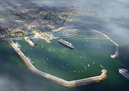
The complete picture in which everyone's fantasies can be fulfilled
The mock-up showing one liner already in Dun Laoghaire with another one, Heaven help us, apparently heading into port at high speed to join her, is a masterpiece of the good old soft-focus technique...Sailing and boating are shown as continuing merrily in all parts of the harbour (right in the way of that incoming liner), while the Naval Vessel seems to have acquired an entirely new alongside facility down the East Pier, as the new swimming pool barge (which seems to have got even larger than expected) has taken over the time-honoured Naval/Guest of Honour berth off the National Yacht Club.
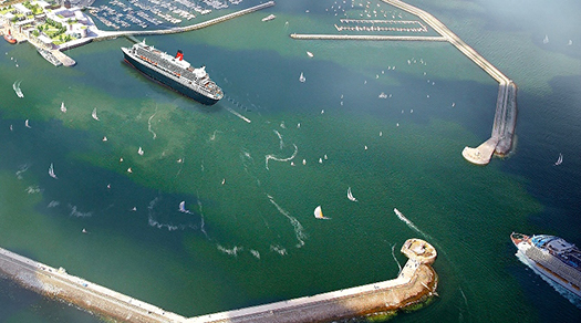
Are they planning a raft-up of cruise liners? A Cunarder already berthed is about to be disturbed by the arrival of one of the new breed of apartment-block cruise liners, which is heading into the entrance at a fine old speed despite the presence of tiny sailing boats between her and the new berth.
As for the Carlisle Pier, it has been glamorized beyond recognition, and it seems to have reinvented itself as a Tall Ships venue. We'll allow anything on the Carlisle Pier so long as it prevents the creation of that gloom-laden notion, an Irish Diaspora Centre. Those who think that the focal point of a harbour devoted to sport and recreation should have at its core a Visitor Centre devoted to the sad topic of enforced economic emigration really do need to have their collective heads examined.
By utilising the view from the northeast, the main computer-generated image enhances the apparent distance between the berthed liner and the harbour mouth, making the outer part of the harbour seem much more spacious than it really will be if a liner is in port. And as a final touch, a Cunarder seems to have been used to fill the role of the visiting ship - they are much more handsome vessels than the usual run of cruise liners, and the one shown is certainly smaller than the latest batch of floating apartment blocks.
So how would it do if they fitted this little machine into the proposed new berth? The freshly-out-of-the-box Anthem of the Seas is 347.1 metres in length, which means she is slightly longer than a third of a kilometre – she's longer than the London Shard is tall. Thus she chimes in at 1,139ft in old money, making her only a couple of hundred feet less than a quarter of a mile from bow to stern.
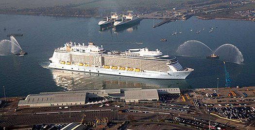
Anthem of the Seas. Almost a quarter of a mile long. 5,000 passengers. 3,000 crew. Yet they still need robotic bar-tenders. Grotesque. Bizarre.......
The Anthem carries 5,000 passengers, plus 3,000 crew and staff, and those on-board guests of a thirsty disposition – which seems to include the majority of cruise liner passengers – will be delighted to hear that the vessel's many gizmos include robotic bar-tenders.
It simply boggles the mind to imagine what Dun Laoghaire would look like at high water with the likes of the Anthem of the Seas plumb in the middle of the handsome harbour. "Grotesque and bizarre" may be better known in another context in Ireland, but in this case, they certainly deserve another couple of laps.
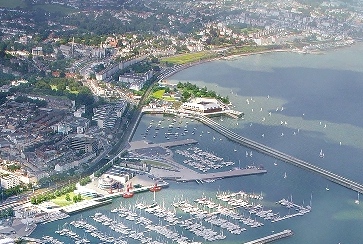
The southwest corner of the harbour could be transformed with a marina in the Coal Harbour, and a new Venice Lido-style development in Seapoint Bay.
So busy have we been looking at the possible spatial re-arrangement of the middle of the harbour that only obsessives like me will have looked into every corner of this fantasy Dun Laoghaire. So to make another point, we've also focused in on the southwest area, where it seems that there's going to be a new marina in the Coal Harbour (they already have the access bridge with the pontoon for landing passengers from cruise liners anchored off) and beyond it that not entirely un-scruffy southwest corner of the harbour seems to have been transformed with a Lido-style development worthy of Venice outside the harbour apparently serving a new public dinghy club which will sail between the West Pier and Seapoint, thereby removing troublesome and undisciplined little sailboats from within the harbour at a stroke.
In summertime, it would seem attractive enough. But a very important part of Dun Laoghaire is the sailing school element, which is at its peak in summer but functions virtually on a year-round basis. When sailing school activity is at its busiest, Dun Laoghaire becomes the old granite pond where it's safe to sail. All the little boats pootling about on it are under constant observation, and when the wind gets up and you get into a spot of bother, the worst that will happen to you is that you'll end up against a pier wall with a loss of dignity, rather than being blown out into the open waters of Dublin Bay and beyond, as can so easily happen in the waters off Seapoint.
But not to worry. We have just come by the schedule for cruise liner visits to Dun Laoghaire in 2015. They would of course have to anchor off, but even so in winter they head south – Anthem of the Seas will spend our winters in Australia and New Zealand. The schedule for this year shows that the first vessel – the 3,900-passenger Splendida – will be arriving on May 11th, and she'll also be the last biggie, on 29th August. After that the only caller is the 2,500-passenger tiddler called the Mein Schiff, and she's arrives on 18th September.
Presumably the season will be a little longer with an in-port berth, but even so it's unlikely there'll be any vessel of significance taking up Dun Laoghaire Harbour between the end of September and the beginning of April. So who's for winter sailing, then?
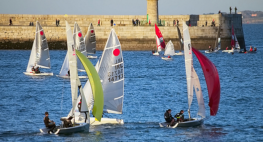 The old granite pond functioning very well as a racing area and training water. This is Dun Laoghaire during sailing's off season - will it become the only in-harbour sailing season?


