


#HistoricBoats - A team of scientists aboard the Marine Institute's research vessel Celtic Voyager has revealed detailed images of World War I shipwrecks in the Irish Sea.
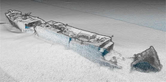
The team, led by Dr Ruth Plets of the School of Environmental Sciences at Ulster University, set out to capture the highest resolution acoustic data possible of WWI shipwrecks lost in the Irish Sea, using a new multi-beam system (EM2040) on board the RV Celtic Voyager to get the best data ever acquired over these wrecks.
"We were able to capture the most detailed images of the entirety of the wrecks ever," said Dr Plets. "Some of the wrecks, which are too deep to be dived on, have not been seen in 100 years. So this is the first time we can examine what has happened to them, during sinking and in the intervening 100 years, and try to predict their future preservation state."
Among the shipwrecks surveyed were the SS Chirripo, which sank in 1917 off Black Head in Co Antrim after she struck a mine; the SS Polwell, which was torpedoed in 1918 northeast of Lambay Island; and the RMS Leinster, which sank in 1918 after being torpedoed off Howth Head, killing over over 500 people - the single greatest loss of live in the Irish Sea.
Marine Institute chief executive Dr Peter Heffernan welcomed the achievements of the survey, supported by the competitive ship-time programme, saying: "The multidisciplinary team is making an important contribution to understanding and protecting our maritime heritage and to our ability to manage our marine resource wisely."
Explaining how the survey was carried out, Dr Plets added: "We moved away from traditional survey strategies by slowing the vessel right down to allow us to get many more data points over the wreck, with millions of sounding per wreck."
"The detail is amazing as we can see things such as handrails, masts, the hawse pipe – where the anchor was stored – and hatches. Some of the vessels have split into sections, and we can even see details of the internal structure. With the visibility conditions in the Irish Sea, no diver or underwater camera could ever get such a great overview of these wrecks."
As well as acoustic imaging, the team collected samples from around the wreck to see what its potential impact is on the seabed ecology. Sediment samples were also taken for chemical analysis to determine if these wrecks cause a concern for pollution.
The project is carried out to coincide with WWI centenary commemorations, noted Dr Plets. "We often forget the battles that were fought in our seas; more emphasis is put on the battles that went on in the trenches. However, at least 2,000 Irishmen lost their lives at sea, but unlike on land, there is no tangible monument or place to commemorate because of the location on the bottom of the sea.
"In the Republic of Ireland there is a blanket protection of all wrecks older than 100 years, so all these will become protected over the next few years. To manage and protect these sites for future generations, we need to know their current preservation state and understand the processes that are affecting the sites."
The next step for the team is to use the data collected to create 3D models which can be used for archaeological research, heritage management and dissemination of these otherwise inaccessible sites to the wider public.
"There is so much data, it will take us many months if not years, to work it all up," said Dr Plets. "Some of the wrecks are in a very dynamic environment and we are planning to survey these vessels again next year to see if there is a change, especially after the winter storms. That will give the heritage managers a better idea if any intervention measures need to be taken to protect them.
"These data could well signal a new era in the field of maritime archaeology. We hope it will inspire a new generation of marine scientists, archaeologists and historians to become involved. Above all, we want to make the general public, young and old, aware of the presence of such wrecks, often located only miles off their local beach."
The research survey was supported by the Marine Institute, through its Ship-Time Programme, funded under the Marine Research Sub-Programme by the Government.
The diverse team included maritime archaeologists Rory McNeary from the Northern Ireland Department of the Environment and Kieran Westley from the University of Southampton; geologists Rory Quinn and Ruth Plets, both Ulster University; biologists Annika Clements from Agri-Food and Biosciences Institute and Chris McGonigle from Ulster University; Ulster University marine science student Mekayla Dale; and hydrographer Fabio Sacchetti from the Marine Institute who works on Ireland's national seabed mapping programme INFOMAR, run jointly with the Geological Survey of Ireland.
The team blogged about the seven-day survey at Scientists@Sea.


 is expected to be among the starters of the second ISORA Viking Marine Irish Coastal Race off Dun Laoghaire Harbour this Saturday morning")


 taking the treasured double - “provisional” first in line honours and first in Leg four IRC handicap ranking")


 Michael Murphy Schull Harbour Sailing Club (SHSC), Eric Coogan Heineken Ireland, Mark Murphy, Commodore SHSC, Jack Allen SHSC, Carmel O'Regan SHSC, Cornelious Ndlovu, Schull Harbour Hotel Operations Manager and Derval Murphy SHSC")


