Menu

Ireland's sailing, boating & maritime magazine

Inland afloat headers


Displaying items by tag: record

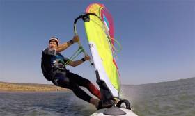
#SpeedRecord - Oisín van Gelderen has released an extended video of his Irish speed sailing record-setting run in the south of France last spring.

As previously reported on Afloat.ie, the windsurfer took to the lagoon at La Palme in the Occitanie region on 6 April 2017, after many days of waiting for the right conditions.

His new outright Irish speed sailing record of 42.16 knots over 500 metres was later ratified by the World Speed Sailing Record Council (WSSR), smashing the late John Kenny’s then longstanding record.

“All along it was my goal to try and break the 50 knot barrier (even as a VMax peak), and push my 500m speed (and the Irish record) up as close to 50 as I could,” he told Afloat.ie.

“Unfortunately the conditions didn't allow (wind not strong enough or at the wrong angle), and although the speed I set in La Palme broke my late friend John Kenny’s previous WSSRC 500m Irish Record by a couple of knots, ironically my own GPS Speeds are much faster.

Van Gelderen added: “I have national GPS Records too by GPS - which is much cheaper to do as I can concentrate on chasing the wind and finding the perfect location such as BunBeg in Donegal, or the Dungarvan Speed Strip at Abbeyside.

“But WSSRC 500m ratified speeds are still considered the ‘official’ national/world records.”

Afloat’s sailor of the month for September 2010 said that the current season has so far not been conducive to GPS speed sailing in Ireland.

“We have had plenty of wind, but never at the right angle - when the tide is also correct to give the right conditions.

“So for me the chase continues. and I will enter the two other WSSRC events this year – one again in the south of France at Le Rouet beach, and the second in Luderitz, Namibia."

Van Gelderen said he has tried to get to Namibia’s Skeleton Coast, where Paul Larsen set the outright record on Vestas Sailrocket 2 in 2012, for a number of years.

“It’s the ultimate course,” he says of the Luderitz Speed Challenge, “where all the world records and top 40 fastest speeds in the world come from.”

Afloat.ie wishes Oisín the best of luck in his efforts to make a mark for Ireland on the world speed sailing stage.

Published in Surfing

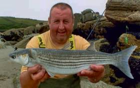
#Angling - Dublin angler Ian Mulligan has broken the golden grey mullet record, which was established as recently as 2014.

The new record, weighing 1.29 kg, was caught at Rosscarbery, Co Cork on 4 July 2017 and was recently ratified by the Irish Specimen Fish Committee (ISFC), which has just published its annual report for 2017.

The ISFC, which is supported by Inland Fisheries Ireland, is an independent voluntary body which verifies and records the capture of large fish caught on rod by anglers in freshwater and marine waters.

As well as the new record, detailed information on 422 specimen fish (large fish) taken by anglers from venues throughout Ireland in 2017, comprising many different species, is detailed in the report.

The main species were smaller shark species like smooth hound and spurdog and carp, the latter of which dominated freshwater. All fish were caught, weighed, measured and released.

The Irish Specimen Fish Committee Report 2017 is available to download HERE. Hard copies of the report are available from Inland Fisheries Ireland offices nationally.

Meanwhile, the ISFC Awards Day, when anglers will be presented with their awards and certificates, will be held on Saturday 17 February in conjunction with the Irish Angling Show in Dublin.

Published in Angling
Tagged under

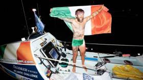
#Rowing: Gavan Hennigan traversed the finish line in the Talisker Whisky Atlantic Challenge tonight and marked himself out as a record breaker. The 35-year-old Galway man took 49 days to complete the row from La Gomera in the Canaries to Antigua in the West Indies. He became the fastest Irishman to row across the Atlantic, less than half the time taken by Sean McGowan (118 days) on this route in 2010; he also beat the record set by Irish-born Briton Tom McClean, who rowed across the North Atlantic in 55 days in 1987.

 Hennigan (35) won an exciting battle with the three-man American Oarsmen to take third of the 12 boats in the race. The American crew pushed hard over the final week and almost caught the Irishman. Though they covered impressive distances each day, Hennigan matched and even outpaced them.

 The crew which won, Latitude 35, set a new world record. It had a four-man crew, as did the second boat to finish, Row for James.

 Taking their places behind Hennigan are a four, three trios, two pairs and three solos.

 Hennigan is not the fastest man to row solo across the Atlantic, as stated in one media outlet. In 2013, Charlie Pitcher became the fastest solo rower to cross the Atlantic in an open class boat: he crossed from La Gomera to Barbados in 35 days and 33 minutes. The statistics are available on oceanrowing.com.


 What a wonderful achievement by Gavan Hennigan. When he said he thought he could complete the race in 50 days, I thought it was hugely ambitious for a first-timer. And then he beat it! Amazing.

 You might be able to confirm something for me. Is he now the fastest solo rower over the La Gomera to Antigua course? And do you know where he ranks in the list of solo rowers to cross the Atlantic?

 He told me you were a key part of the team he had ‘on land’. Well done to all!

 Yours,

 Liam Gorman, Rowing Correspondent, The Irish Times

 00353 (0)86 8051830

Published in Rowing

#Rowing: After 5,000 kilometres of rowing, Gavan Hennigan is in a race to the line in the Talisker Whisky Atlantic Challenge. The three men of American Oarsmen are finishing fast, hoping to take third from the Irishman in the row from the Canary Islands to the West Indies. The American boat has been hitting remarkable numbers (93 nautical miles per day/172 km) but Hennigan retains a slight lead as the crews dash to the finish in English Harbour in Antigua. Both crews should finish late on Wednesday night or early on Thursday.

 The race started on December 14th in the Canary Islands. Hennigan (35) is set for a new Irish record for a solo oarsman rowing across an ocean. The crew which won, Latitude 35, set a new world record. It had a four-man crew, as did the second boat to finish, Row for James.   

Published in Rowing

#RecordWave - Nineteen metres is the height of what’s being called the world’s largest wave, recorded recently off the North West Coast of Ireland.

Independent.ie reports on the record-breaking swell detected by a weather buoy in the North Atlantic between Ireland and Iceland, following what the World Meteorological Organization’s (WMO) Commission for Climatology described as a “very strong” cold front that passed through at more than 80km per hour.

WMO Assistant Secretary-General Wenjian Zhang said: ”This is the first time we have ever measured a wave of 19 metres. It is a remarkable record.”

The new measurement beats the previous record of 18.275 metres recorded in the North Atlantic nine years ago.

But while the news is causing gasps around the internet, for some it only confirms what’s long been known — that Ireland is on the doorstep of a big wave paradise.

Indeed, Ireland’s North West is no stranger to monster swells, with the giant surf offshore from Mullaghmore in Co Sligo a well-kept secret among the big wave surfing fraternity.

Published in Coastal Notes

#Rowing - Four intrepid British women were rescued from the Mid Atlantic in the early hours of this morning (Sunday 14 February) after capsizing during a rowing record attempt for charity.

As the Guardian reports, Gemma Chalk, Clare Lanyon, Jane McIntosh and Olivia Wilson were aiming to break the women's rowing speed record from the Canary Islands to Barbados when they lost their oars and GPS system after a series of capsizes some 400 nautical miles off Cape Verde.

But the women were able to get in contact with the UK Coastguard by satellite phone and activate an emergency beacon to direct passing vessels to their location – and they were finally picked up by a Canada-bound bulk carrier that diverted course to go to their aid.

“This shows you how important it is to be prepared for your voyage and have several means of contacting the coastguard or raising an alarm, even if you are not in UK waters," said UK Coastguard duty controller Ian Guy.

The Guardian has more on the story HERE.

Published in Rowing
Tagged under

#Kayaking - It hasn't been the best summer for long-distance kayaking in Ireland, what with Manx duo Keirron Tastagh and George Shaw being forced to abandon their round-Ireland effort three weeks ago.

And that's not to mention exhaustion getting the better of pizza-oven maker Hendrik Lepel on the first leg of his voyage from Kinsale to Germany.

But two expeditions currently under way may have better chances as the weather improves.

The42.ie brings news of Jon Hynes and Sean Cahill's "once in a lifetime" kayaking trip round Ireland, which began on 16 June near the former's Kinsale home.

Taking a clockwise route around the island of Ireland, as of yesterday (Tuesday 30 June) the pair were taking shelter in Broadhaven Bay, Co Mayo awaiting a break in the weather to proceed to Donegal and on to the north coast and the half-way mark.

“It's definitely the pinnacle of expedition kayaking when you’re trying to get around Ireland in this type of weather!" said Hynes, who can boast of some 60 years of kayaking experience between him and Cahill.

However, ahead of them is an even more elite kayaker in the form of Waterford man Mick O'Meara, who as of yesterday was just four days shy of setting a brand new speed record for a solo circumnavigation of Ireland, as The Irish Times reports.

If O'Meara - a multiple-time Liffey Descent winner – reaches his hometown of Tramore by this Friday 3 July, he will have shaven two days off the record set by Jeff Allen and Harry Whelan on the 1,200km voyage in 2011.

Published in Kayaking

#roundirelandspeedrecord – With arguably the hardest part of the 700–mile journey already over, the northabout Oman Sail Trimaran is 75–miles off the Sligo/Mayo coast and on target to break the Round Ireland Speed Sailing record of one day and 20 hours. Having covered 300 nautical miles in 19–hours, the fastest part of this voyage is yet to come.
The six man crew were heading in a southerly direction (190 degrees) just before noon, expecting to crack sheets and accelerate down the west coast in some forecasted big winds, ready to reach estimated speeds of over 30–knots before the Fastnet rock.  

Published in Offshore

#omansail – The Oman Sail Trimaran crossed the Dublin Bay start line and headed northabout just after 6pm this evening in its latest bid to break the twenty–year Round Ireland Speed Record held by the late American adventurer Steve Fossett. French skipper Sidney Gavignet at the helm of the 70–footer cleared the Kish lighthouse start line, flying a hull and producing a cloud of spray as one of the fastest boats in the world reached full speed. Gavignet must beat a 44–hour record and be back on Dublin Bay just after lunch on Wednesday. 

Winds on Dublin bay were at 18–knots and gusting to over 25 this evening presenting ideal conditions for this professional crew. Onboard are Alex Pella from Spain and Jean Baptiste Levaillant together with three Omani sailors and skipper Gavignet.

The southerly direction of the Dublin Bay breeze produced lumpy, one metre waves, giving Irish World Speed Sailing Commissioner Chris Moore a difficult berth for officiating the record bid from the Dublin Bay Sailing Club starting vessel located just off the Burford bank.

Having arrived from France only this morning, Gavignet took only the briefest pitstop at the National Yacht Club in Dun Laoghaire Harbour before heading back out to sea for what amounts to his third attempt at the Round Ireland speed record in recent years. Gavignet tried to break the record previously in 2013 but was beaten back by strong winds in the Irish Sea. By starting this evening he has made good on a promise to return and make a record attempt.

With potentially only one night at sea, which must be helpful for record-breaking, the current forecast suggests there's just a chance of some nor'east before they get to the South Rock, and there's a chance also of a flat spot on Tuesday evening. But either way it's a good forecast for Oman who must average 16–knots to be in with a chance.

Last season, the trimaran crossed the finish line of the 2014 Sevenstar Round Britain and Ireland Race off the Royal Yacht Squadron in Cowes in August with an elapsed time of three days, 03 hours, 32 minutes, 36 seconds breaking the previous World Record for a multihull held by Banque Populaire 5 in 2011, by 16 minutes, 38 seconds.

Within minutes of crossing the line this evening, the 70–foot colourful vessel had cleared the capital's waters and disappeared into the mist of the Irish Sea. Her six man crew recognising there are over 700–miles between them and a record that has stood the test of time since 1993. In September 1993, Fossett, (sailing with Con Murphy, Cathy MacAleavey, David Scully and Brian Thompson) put the Kish astern again after 44 hours 42 minutes and 20 seconds an average of 15.84 knots. It's a record which has stood for over 19 years but wiill it still be standing on Wednesday?  Sources close to the crew say they are confident of knocking up to ten hours off the record time and are expecting to be home by Wednesday morning. 


Published in News Update

#englishchannelsailing – The San Francisco-based Lending Club report that its CEO Renaud Laplanche and co-skipper Ryan Breymaier established a new world speed sailing record across the English Channel.

The sailors went from the Royal Yacht Squadron Cowes, Isle of Wight to Dinard, France, in 5 hours, 15 minutes, subject to ratification by the World Speed Sailing Record Council, aboard their 105-foot offshore trimaran Lending Club 2 at an average speed of 26.36 knots.

Other crewmembers included Jan Majer, Stanislas Delbarre, Olivier Laplanche, navigator Boris Herrmann, French racing veterans Jean-Baptiste Le Vaillant and Roland Jourdain, and OBR Quin Bisset. Shore-based weather routing was provided by Wouter Verbraak.

The previous record of 5 hours, 23 minutes was established by skipper Brian Thompson, Irish navigator Adrienne Cahalan and the crew of Maiden II, a 110-foot catamaran, in September 2002 at an average speed of 25.6 knots.

Published in Offshore
Page 1 of 3

General Information on using Waterways Ireland inland navigations

Safety on the Water

All users of the navigations are strongly recommended to make themselves aware of safety on the water for whatever activity they are involved in and to read the advice offered by the various governing bodies and by:

The Dept. of Transport, Ireland: www.gov.ie/transport and The Maritime and Coastguard Agency, UK, The RNLI – Water Safety Ireland for information in terms of drowning prevention and water safety.

Registration of Vessels

All vessels using the Shannon Navigation, which includes the Shannon-Erne Waterways and the Erne System must be registered with Waterways Ireland. Only open undecked boats with an engine of 15 horsepower or less on the Shannon Navigation, and vessels of 10 horsepower or less on the Erne System, are exempt. Registration is free of charge.

Craft registration should be completed online at: https://www.waterwaysireland.org/online-services/craft-registration

Permits for use of the Grand and Royal Canals and the Barrow Navigation

All vessels using the Grand and Royal Canals and the Barrow Navigation must display appropriate valid Permit(s) i.e A Combined Mooring and Passage Permit (€126) and if not intending to move every five days, an Extended Mooring Permit (€152).

Permit applications should be completed online at: https://www.waterwaysireland.org/online-services/canal-permits

Passage on the Royal and Grand Canals – Dublin Area

For boat passage through the locks east of Lock 12 into / out of Dublin on either the Royal or Grand Canals, Masters are requested to contact the Waterways Ireland Eastern Regional Office (M-F 9.30am-4.30pm) on tel: +353(0)1 868 0148 or email [email protected] prior to making passage in order to plan the necessary lock-keeping assistance arrangements.

On the Grand Canal a minimum of two days notice prior to the planned passage should be given, masters should note that with the exception of pre-arranged events, a maximum of 2 boats per day will be taken through the locks, travelling either east or west.

Movements in or out of the city will be organised by prior arrangement to take place as a single movement in one day. Boaters will be facilitated to travel the system if their passage is considered to be safe by Waterways Ireland and they have the valid permit(s) for mooring and passage.

Newcomen Lifting Bridge

On the Royal Canal two weeks’ notice of bridge passage (Newcomen Lifting Bridge) is required for the pre-set lift date, and lock assistance will then also be arranged. A minimum of 2 boats is required for a bridge lift to go ahead.

Waterways Ireland Eastern Regional Office (Tel: +353(0)1 868 0148 or [email protected] ) is the point of contact for the bridge lift.

A maximum number of boats passing will be implemented to keep to the times given above for the planned lifts (16 for the Sat / Sun lifts & 8 for the weekday lifts). Priority will be given on a first come first served basis.

On day of lift, boaters and passengers must follow guidance from Waterways Ireland staff about sequence of passage under bridge & through Lock 1, and must remain within signed and designated areas.

Events Held on the Waterways

All organised events taking place on the waterways must have the prior approval of Waterways Ireland. This is a twelve week process and application forms must be accompanied with the appropriate insurance, signed indemnity and risk assessment. The application should be completed on the Waterways Ireland events page at :

https://www.waterwaysireland.org/online-services/event-approval

Time Limits on Mooring in Public Harbours

On the Shannon Navigation and the Shannon-Erne Waterway craft may berth in public harbours for five consecutive days or a total of seven days in any one month.

On the Erne System, revised Bye Laws state that: No master or owner shall permit a vessel, boat or any floating or sunken object to remain moored at or in the vicinity of any public mooring, including mooring at any other public mooring within 3 kilometres of that location, for more than 3 consecutive days and shall not moor at that same mooring or any other public mooring within 3 kilometres of that location within the following 3 consecutive days without prior permission by an authorised official.

Winter Mooring on the Shannon Navigation and Shannon Erne Waterway

Winter mooring may be availed of by owners during the period 1 Nov to 31 Mar by prior arrangement and payment of a charge of €63.50 per craft. Craft not availing of Winter Mooring must continue to comply with the “5 Day Rule”. Winter Mooring applications should be completed online at : https://www.waterwaysireland.org/online-services/winter-moorings-booking

Owners should be aware that electricity supply and water supply to public moorings is disconnected for the winter months. This is to protect against frost damage, to reduce running costs and to minimise maintenance requirements during the winter months.

Vessel owners are advised that advance purchasing of electricity on the power bollards leading up to the disconnection date should be minimal. Electricity credit existing on the bollards will not be recoverable after the winter decommissioning date. Both services will be reinstated prior to the commencement of the next boating season.

Smart Cards

Waterways Ireland smart cards are used to operate locks on the Shannon Erne Waterway, to access the service blocks, to use the pump-outs along the navigations, to avail of electrical power at Waterways Ireland jetties.

Berthing in Public Harbours

Masters are reminded of the following:

  • Equip their vessel with mooring lines of appropriate length and strength and only secure their craft to mooring bollards and cleats provided for this purpose.
  • Ensure the available berth is suitable to the length of your vessel, do not overhang the mooring especially on finger moorings on floating pontoon moorings.
  • Ensure mooring lines, electric cables and fresh water hoses do not create a trip hazard on public jetties for others users.
  • Carry sufficient fenders to prevent damage to your own vessel, other vessels and WI property.
  • Allow sufficient space between your vessel and the vessel ahead /astern (c.1m) for fire safety purposes and /or to recover somebody from the water.
  • Do not berth more than two vessels side by side and ensure there is safe access/egress at all times between vessels and onto the harbour itself.
  • Do not berth in such a way to prevent use of harbour safety ladders, slipways or pump-outs.
  • Do not allow the bow of your vessel to overhang the walkway of a floating mooring thus creating a hazard for others with an overhanging anchor or bow fendering.
  • Animals are not allowed to be loose or stray at any time.
  • Harbour and jetty infrastructure such as railings, power pedestals, fresh water taps, electric light poles, safety bollards, ladders etc are not designed for the purpose of mooring craft , they will not bear the strain of a vessel and will be damaged.
  • At Carrybridge on the Erne System, Masters of vessels are not permitted to use stern on mooring. Masters of vessels must use the mooring fingers for mooring of vessels and for embarkation / disembarkation from vessels.

Passenger Vessel Berths

Masters of vessels should not berth on passenger vessel berths where it is indicated that an arrival is imminent. Passenger vessels plying the navigations generally only occupy the berths to embark and disembark passengers and rarely remain on the berths for extended periods or overnight.

Lock Lead-in Jetties

Lead-in jetties adjacent to the upstream and downstream gates at lock chambers are solely for the purpose of craft waiting to use the lock and should not be used for long term berthing.

Vessel Wake

Vessel wake, that is, the wave generated by the passage of the boat through the water, can sometimes be large, powerful and destructive depending on the hull shape and engine power of the vessel. This wake can be detrimental to other users of the navigation when it strikes their craft or inundates the shoreline or riverbank. Masters are requested to frequently look behind and check the effect of their wake / wash particularly when passing moored vessels, on entering harbours and approaching jetties and to be aware of people pursuing other activities such as fishing on the riverbank.

Speed Restriction

A vessel or boat shall not be navigated on the Shannon Navigation at a speed in excess of 5 kph when within 200 metres of a bridge, quay, jetty or wharf, when in a harbour or canal or when passing within 100 metres of a moored vessel or boat.

Vessels navigating the Shannon-Erne Waterway should observe the general 5 kph speed limit which applies along the waterway. This is necessary in order to prevent damage to the banks caused by excessive wash from vessels.

Vessels navigating the Erne System should observe the statutory 5kt / 6mph / 10kph speed limit areas.

A craft on the Royal and Grand canals shall not be navigated at a speed in excess of 6km per hour.

A craft on the Barrow Navigation shall not be navigated at a speed in excess of 11km per hour except as necessary for safe navigation in conditions of fast flow.

Bank Erosion

Narrow sections of all the navigations are particularly prone to bank erosion due to the large wash generated by some craft. Masters are requested to be vigilant and to slow down to a speed sufficient to maintain steerage when they observe the wash of their craft inundating the river banks.

Unusual Waterborne Activity

Unusual waterborne vessels may be encountered from time to time, such as, hovercraft or amphibious aircraft / seaplanes. Masters of such craft are reminded to apply the normal “Rule of the Road” when they meet conventional craft on the water and to allow extra room to manoeuvre in the interest of safety.

Sailing Activity

Mariners will encounter large numbers of sailing dinghies from late June to August in the vicinity of Lough Derg, Lough Ree and Lower Lough Erne. Sailing courses are marked by yellow buoys to suit weather conditions on the day. Vessels should proceed at slow speed and with due caution and observe the rules of navigation when passing these fleets, as many of the participants are junior sailors under training.

Rowing

Mariners should expect to meet canoes and vessels under oars on any part of the navigations, but more so in the vicinity of Athlone, Carrick-on-Shannon, Coleraine, Enniskillen and Limerick. Masters are reminded to proceed at slow speed and especially to reduce their wash to a minimum when passing these craft as they can be easily upset and swamped due to their very low freeboard and always be prepared to give way in any given traffic situation.

Canoeing

Canoeing is an adventure sport and participants are strongly recommended to seek the advice of the sport’s governing bodies i.e Canoeing Ireland and the Canoe Association of Northern Ireland, before venturing onto the navigations.

Persons in charge of canoes are reminded of the inherent danger to these craft associated with operating close to weirs, sluice gates, locks and other infrastructure particularly when rivers are in flood and large volumes of water are moving through the navigations due to general flood conditions or very heavy localised precipitation e.g. turbulent and broken water, stopper waves. Shooting weirs is prohibited without prior permission of Waterways Ireland.

Canoeists should check with lockkeepers prior entering a lock to ensure passage is done in a safe manner. Portage is required at all unmanned locks.

Canoe Trail Network – "Blueways"

Masters of powered craft are reminded that a canoe trail network is being developed across all navigations and to expect more organised canoeing along these trails necessitating slow speed and minimum wash when encountering canoeists, rowing boats etc

Rockingham and Drummans Island Canals – Lough Key

It is expected that work on Rockingham and Drummans Island Canals on Lough Key will be completed in 2021. Access to these canals will be for non-powered craft only, eg canoes, kayaks, rowing boats.

Fast Powerboats and Personal Watercraft (Jet Skis)

Masters of Fast Powerboats (speed greater than 17kts) and Personal Watercraft (i.e.Jet Skis) are reminded of the inherent dangers associated with high speed on the water and especially in the confines of small bays and narrow sections of the navigations. Keeping a proper look-out, making early alterations to course and /or reducing speed will avoid conflict with slower vessels using the navigation. Personal Watercraft are not permitted to be used on the canals.

Towing Waterskiers, Wakeboarders, Doughnuts etc

Masters of vessels engaged in any of these activities are reminded of the manoeuvring constraints imposed upon their vessel by the tow and of the added responsibilities that they have to the person(s) being towed. These activities should be conducted in areas which are clear of conflicting traffic. It is highly recommended that a person additional to the master be carried to act as a “look-out” to keep the tow under observation at all times.

Prohibition on Swimming

Swimming in the navigable channel, particularly at bridges, is dangerous and is prohibited due to the risk of being run over by a vessel underway in the navigation.

Age Restrictions on operating of powered craft

In the Republic of Ireland, Statutory Instrument 921 of 2005 provides the legal requirements regarding the minimum age for operating of powered craft. The Statutory Instrument contains the following requirements:

- The master or owner of a personal watercraft or a fast power craft shall take all reasonable steps to ensure that a person who has not attained the age of 16 years does not operate or control the craft

- The master or owner of a pleasure craft powered by an engine with a rating of more than 5 horse power or 3.7 kilowatts shall take all reasonable steps to ensure that a person who has not attained the age of 12 years does not operate or control the craft.

Lifejackets and Personal Flotation Devices (PFDs)

Lifejackets and PFD’s are the single most important items of personal protective equipment to be used on a vessel and should be worn especially when the vessel is being manoeuvred such as entering / departing a lock, anchoring, coming alongside or departing a jetty or quayside.

In the Republic of Ireland, Statutory Instrument 921 of 2005 provides the legal requirements regarding the wearing of Personal Flotation Devices. The Statutory Instrument contains the following requirements:

- The master or owner of a pleasure craft (other than a personal watercraft) shall ensure, that there are, at all times on board the craft, sufficient suitable personal flotation devices for each person on board.

- A person on a pleasure craft (other than a personal watercraft) of less than 7 metres length overall shall wear a suitable personal flotation device while on board an open craft or while on the deck of decked craft, other than when the craft is made fast to the shore or at anchor.

- The master or owner of a pleasure craft (other than a personal watercraft) shall take all reasonable steps to ensure that a person who has not attained the age of 16 years complies with paragraph above.

- The master or owner of a pleasure craft (other than a personal watercraft), shall take all reasonable steps to ensure that a person who has not attained the age of 16 years wears a suitable personal flotation device while on board an open craft or while on the deck of a decked craft other than when it is made fast to the shore or at anchor.

- The master or owner of a pleasure craft (other than a personal watercraft) shall take all reasonable steps to ensure that a person wears a suitable personal flotation device, at all times while – (a) being towed by the craft, (b) on board a vessel or object of any kind which is being towed by the craft.

Further information is available at: http://www.irishstatutebook.ie/eli/2005/si/921/made/en/print

Firing Range Danger Area – Lough Ree

The attention of mariners is drawn to the Irish Defence Forces Firing Range situated in the vicinity of buoys No’s 2 and 3, on Lough Ree on the Shannon Navigation. This range is used regularly for live firing exercises, throughout the year, all boats and vessels should stay clear of the area marked with yellow buoys showing a yellow "X" topmark and displaying the word "Danger".

Shannon Navigation, Portumna Swing Bridge Tolls

No attempt should be made by Masters’ of vessels to pay the bridge toll while making way through the bridge opening. Payment will only be taken by the Collector from Masters when they are secured alongside the jetties north and south of the bridge.

Navigating from Killaloe to Limerick on the Shannon Navigation

The navigation from Killaloe to Limerick involves passage through Ardnacrusha locks, the associated headrace and tailrace and the Abbey River into Limerick City. Careful passage planning is required to undertake this voyage. Considerations include: lock passage at Ardnacrusha, water flow in the navigation, airdraft under bridges on Abbey River in Limerick, state of tide in Limerick

Users are advised to contact the ESB Ardnacrusha hydroelectric power station (00353 (0)87 9970131) 48 hours in advance of commencing their journey to book passage through the locks at Ardnacrusha. It is NOT advised to undertake a voyage if more than one turbine is operating (20MW), due to the increased velocity of flow in the navigation channel, which can be dangerous. To ascertain automatically in real time how many turbines are running, users can phone +353 (0)87 6477229.

For safety reasons the ESB has advised that only powered craft with a capacity in excess of 5 knots are allowed to enter Ardnacrusha Headrace and Tailrace Canals.

Passage through Sarsfield Lock should be booked on +353-87-7972998, on the day prior to travel and it should be noted also that transit is not possible two hours either side of low water.

A Hydrographic survey in 2020 of the navigation channel revealed that the approach from Shannon Bridge to Sarsfield Lock and the Dock area has silted up. Masters of vessels and water users are advised to navigate to the Lock from Shannon bridge on a rising tide one or two hours before High Tide.

Lower Bann Navigation

The attention of all users is drawn to the “Users Code for the Lower Bann”, in particular to that section covering “Flow in the River” outlining the dangers for users both on the banks and in the navigation, associated with high flow rates when the river is in spate. Canoeists should consult and carry a copy of the “Lower Bann Canoe Trail” guide issued by the Canoe Association of Northern Ireland. Users should also contact the DfI Rivers Coleraine, who is responsible for regulating the flow rates on the river, for advisory information on the flow rates to be expected on any given day.

DfI Rivers Coleraine. Tel: 0044 28 7034 2357 Email: [email protected]

Lower Bann Navigation – Newferry – No wake zone

A No Wake Zone exists on the Lower Bann Navigation at Newferry. Masters of vessels are requested to proceed at a slow speed and create no wake while passing the jetties and slipways at Newferry.

Overhead Power Lines (OHPL) and Air draft

All Masters must be aware of the dangers associated with overhead power lines, in particular sailing vessels and workboats with cranes or large air drafts. Voyage planning is a necessity in order to identify the location of overhead lines crossing the navigation.

Overhead power line heights on the River Shannon are maintained at 12.6metres (40 feet) from Normal Summer level for that section of navigation, masters of vessels with a large air draft should proceed with caution and make additional allowances when water levels are high.

If a vessel or its equipment comes into contact with an OHPL the operator should NOT attempt to move the vessel or equipment. The conductor may still be alive or re-energise automatically. Maintain a safe distance and prevent third parties from approaching due to risk of arcing. Contact the emergency services for assistance.

Anglers are also reminded that a minimum ground distance of 30 metres should be maintained from overhead power lines when using a rod and line.

Submarine Cables and Pipes

Masters of vessels are reminded not to anchor their vessels in the vicinity of submarine cables or pipes in case they foul their anchor or damage the cables or pipes. Look to the river banks for signage indicating their presence.

Water Levels - Precautions

Low Water Levels:

When water levels fall below normal summer levels masters should be aware of:

Navigation

To reduce the risk of grounding masters should navigate on or near the centreline of the channel, avoid short cutting in dog-legged channels and navigating too close to navigation markers.

Proceeding at a slow speed will also reduce “squat” effect i.e. where the vessel tends to sit lower in the water as a consequence of higher speed.

Slipways

Reduced slipway length available under the water surface and the possibility of launching trailers dropping off the end of the concrete apron.

More slipway surface susceptible to weed growth requiring care while engaged in launching boats, from slipping and sliding on the slope. Note also that launching vehicles may not be able to get sufficient traction on the slipway once the craft is launched to get up the incline.

Bank Erosion

Very dry riverbanks are more susceptible to erosion from vessel wash.

Lock Share

Maximising on the number of vessels in a lock will ensure that the total volume of water moving downstream is decreased. Lock cycles should be used for vessels travelling each way.

High Water Levels:

When water levels rise above normal summer level masters should be aware of:

Navigation

Navigation marks will have reduced height above the water level or may disappear underwater altogether making the navigable channel difficult to discern.

In narrow sections of the navigations water levels will tend to rise more quickly than in main streams and air draft at bridges will likewise be reduced.

There will also be increased flow rates particularly in the vicinity of navigation infrastructure such as bridges, weirs, locks etc where extra care in manoeuvring vessels will be required.

Harbours and Jetties

Due care is required in harbours and at slipways when levels are at or near the same level as the harbour walkways' as the edge will be difficult to discern especially in reduced light conditions. It is advised that Personal Flotation Devices be worn if tending to craft in a harbour in these conditions.

Slipways

Slipways should only be used for the purpose of launching and recovering of water craft or other objects from the water. Before using a slipway it should be examined to ensure that the surface has sufficient traction/grip for the intended purpose such as launching a craft from a trailer using a vehicle, that there is sufficient depth of water on the slipway to float the craft off the trailer before the concrete apron ends and that the wheels of the trailer do not drop off the edge of the slipway. That life-saving appliances are available in the vicinity, that the vehicle is roadworthy and capable of coping with the weight of the trailer and boat on the incline. It is recommended that slipway operations are conducted by two persons.

Caution to be Used in Reliance upon Aids to Navigation

The aids to navigation depicted on the navigation guides comprise a system of fixed and floating aids to navigation. Prudent mariners will not rely solely on any single aid to navigation, particularly a floating aid to navigation. With respect to buoys, the buoy symbol is used to indicate the approximate position of the buoy body and the ground tackle which secures it to the lake or river bed. The approximate position is used because of the practical limitations in positioning and maintaining buoys in precise geographical locations. These limitations include, but are not limited to, prevailing atmospheric and lake/river conditions, the slope of and the material making up the lake/river bed, the fact that the buoys are moored to varying lengths of chain, and the fact that the buoy body and/or ground tackle positions are not under continuous surveillance. Due to the forces of nature, the position of the buoy body can be expected to shift inside and outside the charted symbol.

Buoys and perches are also moved out of position or pulled over by those mariners who use them to moor up to instead of anchoring. To this end, mariners should always monitor their passage by relating buoy/perch positions with the published navigation guide. Furthermore, a vessel attempting to pass close by always risks collision with a yawing buoy or with the obstruction that the buoy or beacon/perch marks.

Masters of Vessels are requested to use the most up to date Navigation guides when navigating on the Inland Waterways.

Information taken from Special Marine Notice No 1 of 2023