Menu

Ireland's sailing, boating & maritime magazine

Displaying items by tag: Marine Geology Research Group

Marine scientists from University College Cork have discovered plastic at the bottom of a deep submarine canyon while investigating cold-water coral habitats.

UCC’s Marine Geology Research Group has been investigating cold-water coral habitats in the Porcupine Bank Canyon, some 320km due west of Dingle, on a research expedition led by UCC’s Dr Aaron Lim on board the Marine Institute’s RV Celtic Explorer.

The team had recovered eight novel monitoring stations, called ‘landers’, worth €450,000 and deployed between 700m and 2500m water depth by the Marine Institute’s Remotely Operated Vehicle (ROV) Holland 1 earlier this summer.

The monitoring stations record the speed, temperatures and direction of the currents around these habitats as well as trapping samples of the food, sediments and microplastic being deposited around the corals, to understand conditions and how the corals are coping with changing oceans.

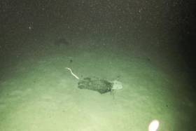
The researchers found plastic in the bottom of one canyon at 2,125m water depth — as deep as ten Eiffel Towers stacked on top of one another.

The reach of human plastic waste is now confirmed as this deep, even 320km offshore.

“It’s always sad to see plastic rubbish in these otherwise pristine habitats. It’s quite incredible that our plastic waste can get this far out and so deep in the oceans,” said Professor Andy Wheeler of UCC, who has pioneered research on cold-water coral mounds offshore of Ireland over the past 20 years.

“I don’t think people think about this when that dump their rubbish. We’re also trying to see if microplastics are being fed to the corals from above. We’ve just got the samples; let’s hope we're wrong.”

“ROV
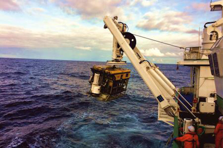
ROV Holland 1 recovering one of the monitoring stations | Photo: UCC

The Porcupine Bank Canyon is teeming with a whole range of cold-water coral habitats, just on Ireland’s doorstep, says Dr Lim.

“The environment is much more dynamic than we thought, with two of the monitoring stations knocked over by the currents; food supply for the coral is variable but the corals are doing okay.

“Some of these habitats have existed for millions of years and have grown so large they resemble hills made of coral, called coral mounds.

“This is the first time eight of these monitoring stations have been deployed and collected using the ROV Holland 1. It will provide scientists with an insight into the processes affecting these cold-water coral habitats, food sources and the impact of microplastics.”

Dr Lim said Ireland’s cold-water coral reefs are found in the cold, dark ocean at water depths of 600m to 1,000m along our continental margin.

“Not only is this expedition vital for understanding these habitats and our impact upon them, it also acts as a baseline to start monitoring how our deep-water habitats here are changing,” he added.

The team has a research agenda which will see them return to the canyon and other habitats alike for a number of years, to monitor the changes in the environment around these habitats. The monitoring stations will be brought back to UCC for detailed analyses.

This research survey is carried out with the support of the Marine Institute, funded under the Marine Research Programme 2014-2020 by the Government to support and promote the Atlantic Ocean Research Alliance, which facilitates common research and knowledge exchange for us to provide healthy, resilient oceans for our future generations.

The survey has also received funding from Science Foundation Ireland, Geological Survey Ireland and UCC.

Published in Marine Science

Marine Protected Areas (MPAs) - FAQS

Marine protected areas (MPAs) are geographically defined maritime areas where human activities are managed to protect important natural or cultural resources. In addition to conserving marine species and habitats, MPAs can support maritime economic activity and reduce the effects of climate change and ocean acidification.

MPAs can be found across a range of marine habitats, from the open ocean to coastal areas, intertidal zones, bays and estuaries. Marine protected areas are defined areas where human activities are managed to protect important natural or cultural resources.

The world's first MPA is said to have been the Fort Jefferson National Monument in Florida, North America, which covered 18,850 hectares of sea and 35 hectares of coastal land. This location was designated in 1935, but the main drive for MPAs came much later. The current global movement can be traced to the first World Congress on National Parks in 1962, and initiation in 1976 of a process to deliver exclusive rights to sovereign states over waters up to 200 nautical miles out then began to provide new focus

The Rio ‘Earth Summit’ on climate change in 1992 saw a global MPA area target of 10% by the 2010 deadline. When this was not met, an “Aichi target 11” was set requiring 10% coverage by 2020. There has been repeated efforts since then to tighten up MPA requirements.

Marae Moana is a multiple-use marine protected area created on July 13th 2017 by the government of the Cook islands in the south Pacific, north- east of New Zealand. The area extends across over 1.9 million square kilometres. However, In September 2019, Jacqueline Evans, a prominent marine biologist and Goldman environmental award winner who was openly critical of the government's plans for seabed mining, was replaced as director of the park by the Cook Islands prime minister’s office. The move attracted local media criticism, as Evans was responsible for developing the Marae Moana policy and the Marae Moana Act, She had worked on raising funding for the park, expanding policy and regulations and developing a plan that designates permitted areas for industrial activities.

Criteria for identifying and selecting MPAs depends on the overall objective or direction of the programme identified by the coastal state. For example, if the objective is to safeguard ecological habitats, the criteria will emphasise habitat diversity and the unique nature of the particular area.

Permanence of MPAs can vary internationally. Some are established under legislative action or under a different regulatory mechanism to exist permanently into the future. Others are intended to last only a few months or years.

Yes, Ireland has MPA cover in about 2.13 per cent of our waters. Although much of Ireland’s marine environment is regarded as in “generally good condition”, according to an expert group report for Government published in January 2021, it says that biodiversity loss and ecosystem degradation are of “wide concern due to increasing pressures such as overexploitation, habitat loss, pollution, and climate change”.

The Government has set a target of 30 per cent MPA coverage by 2030, and moves are already being made in that direction. However, environmentalists are dubious, pointing out that a previous target of ten per cent by 2020 was not met.

Conservation and sustainable management of the marine environment has been mandated by a number of international agreements and legal obligations, as an expert group report to government has pointed out. There are specific requirements for area-based protection in the EU Marine Strategy Framework Directive (MSFD), the OSPAR Convention, the UN Convention on Biological Diversity and the UN Sustainable Development Goals. 

Yes, the Marine Strategy Framework directive (2008/56/EC) required member states to put measures in place to achieve or maintain good environmental status in their waters by 2020. Under the directive a coherent and representative network of MPAs had to be created by 2016.

Ireland was about halfway up the EU table in designating protected areas under existing habitats and bird directives in a comparison published by the European Commission in 2009. However, the Fair Seas campaign, an environmental coalition formed in 2022, points out that Ireland is “lagging behind “ even our closest neighbours, such as Scotland which has 37 per cent. The Fair Seas campaign wants at least 10 per cent of Irish waters to be designated as “fully protected” by 2025, and “at least” 30 per cent by 2030.

Nearly a quarter of Britain’s territorial waters are covered by MPAs, set up to protect vital ecosystems and species. However, a conservation NGO, Oceana, said that analysis of fishing vessel tracking data published in The Guardian in October 2020 found that more than 97% of British MPAs created to safeguard ocean habitats, are being dredged and bottom trawled. 

There’s the rub. Currently, there is no definition of an MPA in Irish law, and environment protections under the Wildlife Acts only apply to the foreshore.

Current protection in marine areas beyond 12 nautical miles is limited to measures taken under the EU Birds and Habitats Directives or the OSPAR Convention. This means that habitats and species that are not listed in the EU Directives, but which may be locally, nationally or internationally important, cannot currently be afforded the necessary protection

Yes. In late March 2022, Minister for Housing Darragh O’Brien said that the Government had begun developing “stand-alone legislation” to enable identification, designation and management of MPAs to meet Ireland’s national and international commitments.

Yes. Environmental groups are not happy, as they have pointed out that legislation on marine planning took precedence over legislation on MPAs, due to the push to develop offshore renewable energy.

No, but some activities may be banned or restricted. Extraction is the main activity affected as in oil and gas activities; mining; dumping; and bottom trawling

The Government’s expert group report noted that MPA designations are likely to have the greatest influence on the “capture fisheries, marine tourism and aquaculture sectors”. It said research suggests that the net impacts on fisheries could ultimately be either positive or negative and will depend on the type of fishery involved and a wide array of other factors.

The same report noted that marine tourism and recreation sector can substantially benefit from MPA designation. However, it said that the “magnitude of the benefits” will depend to a large extent on the location of the MPA sites within the network and the management measures put in place.

© Afloat 2022