


Displaying items by tag: marine warning
Yellow Warning For Small Craft As Storm Barbara Approaches
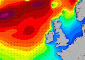
#Weather - Met Éireann has announced a Status Yellow small craft warning for strong gales in effect today (Wednesday 21 December) ahead of Storm Barbara’s expected arrival at the weekend.
Southwest winds will reach Force 8 at times this evening and tonight on coasts from Slyne Head to Rossan Point to Fair Head.
That’s before the deep Atlantic depression, the second winter storm of the current season, tracks eastwards well to the north of Scotland, bringing wet and windy weather across Ireland — and the risk of stormy conditions in the coastal counties of Connacht and Ulster.
Achill Island Coast Guard advises mariners and residents in these areas to expect at least an Status Orange weather warning this Friday, as the projected Force 10 winds are forecast to last up to 24 hours, according to the Connacht Telegraph.
Warning Over Dangers Of Open Water Swimming
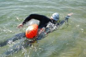
#Swimming - Waterways Ireland advises anyone engaged in open water swimming training of the inherent dangers attached to this activity in locations where there is boating traffic.
A swimmer in the water wearing high visibility head gear will always remain a very small target to see to the master of a powered craft, particularly if:
- The water surface is choppy.
- There is strong glare reflected from the water surface.
- There is difficulty in sighting due to slanting sunshine in early morning or late evening.
- Visibility is poor due to fog, mist or rain.
Swimmers should risk assess their swimming location prior to entering the water, for boat traffic, entry and exit locations, availability of life saving appliances, weather and water conditions.
The presence of a safety boat or kayak will always give enhanced safety and security.
Possible Debris In Irish EEZ From Soyuz Launch

#MarineNotice - The Department of Transport, Tourism and Sport (DTTAS) has been advised by the Government of France about the planned launch of the rocket Soyuz VS15 from Kourou Spaceport in French Guyana on or around next Tuesday 24 May.
Following the launch, some elements of the launcher may land in the Atlantic Ocean around 356km off the Irish coast within the Exclusive Economic Zone (EEZ) of Ireland.
Any shipping within the affected area during the launch period is hereby advised to be alert to the general maritime safety risk in the area.
Co-ordinates and a map of the affected area are included in Marine Notice No 23 of 2016, a PDF of which is available to read or download HERE.
Howth Coast Guard Warns Walkers Over Waves On East Pier
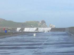
#WaterSafety - Howth Coast Guard has advised walkers to avoid the harbour's East Pier today (Sunday 10 April) due to the danger of breaking waves.
It comes as Met Éireann issues a Status Yellow weather warning for most of the country over strong winds, heavy rainfall and high spring tides with the moon at perigee.
Cork is the worst hit by the current deluge with many parts of the city hit by flooding this morning, as The Irish Times reports.
Gale warnings and small craft warnings are currently in effect around the coast, as easterly gales are expected to surpass Force 6 from Erris Head to Fair Head to Wicklow Head.
Coast Guard unit at scene. More reports coming in of other coastal areas being exposed to waves breaking endangering the...
Posted by Howth Coast Guard on Sunday, 10 April 2016
Marine Notice: Emergency Cable Repair On Approach To Dublin Port
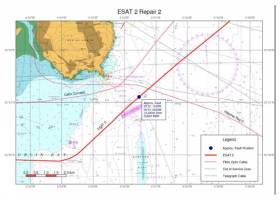
#MarineNotice - The latest Marine Notice from the Department of Transport, Tourism and Sport advises that Global Marine Systems Ltd has been contracted to undertake an emergency repair to the ESAT2 submarine fibre optic telecommunications cable in the Irish Sea within Irish Territorial Waters on the approach to Dublin Port.
The CS Wave Sentinel (Callsign MZBC8) is scheduled to arrive on site tomorrow (Monday 22 February) to commence works. The weather is currently being monitored and this timing could change depending on local conditions.
The repair works will last for approximately five days depending upon weather and other operational conditions.
The vessel will be limited in manoeuvrability and other vessels should give the vessel and its equipment, including cable buoys, a wide berth. It will be listening on VHF Channel 16 during the project.
Full details are included in Marine Notice No 6 of 2016, a PDF of which is available to read or download HERE.
#Weather - Following last week's weather warning ahead of Storm Abigail, which brought gusts of up to 120km/h in north-west counties, Met Éireann has issued another Status Orange alert for all coastal waters.
Southwest gales to strong gales will develop today (Tuesday 17 November) on Irish coastal waters from Belfast Lough to Roche’s Point to Erris Head and on the Irish Sea, reaching storm Force 10 for a time in parts.
Southwest mean winds will reach speeds of 65 to 80 km/h with gusts of up to 130 km/h this afternoon in Munster, Leinster, Galway and Roscommon, moving eastwards in the evening.
Met Éireann adds that there is a risk those limits could be exceeded for a short period, especially in exposed western coastal areas.
According to TheJournal.ie, Clare and Limerick councils are advising the public to avoid travel and stay indoors until the worst of the storm passes late this evening.
Debris Warning For Irish Sea Over Soyuz Rocket Launch
#MarineNotice - Mariners in the waters of Ireland's Exclusive Economic Zone are advised to keep watch for debris that may fall into the sea after a pending Soyuz rocket launch between today 11 September and Monday 21 September.
Marine Notice No 42 of 2015 has co-ordinates of the area where parts are expected to fall following the launch of the Soyuz VS12 space rocket from Kourou Spaceport in French Guyana.
Status Red Weather Warning Issued For West Coast
#Weather - Met Éireann has issued a Status Red weather warning for coastal and mountain areas in the west as winds are predicted to gust as high as 150km/h.
High onshore seas are also expected with the warning for exposed areas in Donegal, Sligo, Mayo, Galway, Clare, Limerick and Kerry that remains in place till tomorrow lunchtime.
Marine Notice: Live Surface To Air Firing Practices At Gormanston Ranges

#MarineNotice - The latest Marine Notice from the Department of Transport, Tourism and Sport advises that the Defence Forces will conduct live surface to air firing practices at Gormanston Ranges on 4 and 5 November 2014 between 10am and 2.30pm each day.
The danger area comprises the lands of Gormanston Aerodrome and the Air and Sea areas contained within a radius of 3 nautical miles centred on Gormanston Aerodrome, with an additional area contained within a segment centred on Gormanston Aerodrome and bearing of 015 degrees true, through Mosney Railway Station and 106 degrees true, through Gormanston Railway Station seawards for a distance of 10 nautical miles.
For the periods while the range is active, the sea zone within the danger area is excluded to all vessels. A Naval Service patrol vessel will enforce the exclusion zone ‘D1’, which is indicated on British Admiralty Chart No 44.
All vessels are advised that they are required to remain outside of the exclusion zone while the range is active. Vessels are also are recommended to carefully monitor the Radio Navigation Warnings that will be broadcast during the firing period.
#MarineNotice - The latest Marine Notice from the Department of Transport, Tourism and Sport (DTTAS) advises that a geophysical cable route survey will begin off the Irish coast at Killala Bay on Wednesday 21 May.
TE SubCom is scheduled to carry out the survey, which involving multibeam echo-sounder bathymetry, side-scan sonar, magnetometer and sub-bottom profiling at Killala Bay heading north to the 12nm limit.
The survey will last for approximately 1 week, weather permitting, and will be carried out by the vessel RV Ridley Thomas (Call sign V7JK2).
The vessel will be towing survey equipment up to 200m astern and will be restricted in its ability to manoeuvre whilst carrying out the survey. The RV Ridley Thomas and any assisting project vessels will be listening on VHF Channel 16 throughout the project.
All vessels, particularly those engaged in fishing, are requested to give the RV Ridley Thomas and its towed equipment a wide berth and keep a sharp lookout in the relevant areas.
Co-ordinates for the survey areas and further details are included in Marine Notice No 30 of 2014, a PDF of which is available to read or download HERE.


 is teaming up with BG Freight Line (BGFL) and Peel Ports in Liverpool and Dublin Port to provide a new service to significantly improve transit times in both directions between Ireland and North America. This first ‘eastbound’ sailing for this new integrated service will be operated by combination container/ro-ro (conro) Atlantic Sun (above photo), sailing New York, May 10, Baltimore, May 13, Norfolk, May 14, Halifax, May 16, connecting in Liverpool with JSP Anna, arriving Dublin, May 26 and Belfast, May 27.")


, at the sod-turning event for the new Deep Water Quay Development at the Rossaveal Fishery Harbour Centre. (Forbairt Ché Dhomhain, Lárionad Chuan Iascaigh Ros An Mhíl) in February")

