Displaying items by tag: Cyanobacteria
Experts Say Years Before Impact of Toxic Algal Blooms on Lough Neagh is Fully Understood
Warning signage is being removed from locations around Lough Neagh following this past summer’s blooms of toxic blue-green algae.
But as BBC News reports, it could be years before the ecological impact on the lough is fully understood.
Ulster Angling Federation chair Gary Houston claimed that the collapse of the Lough Neagh fly, attributed to the cyanobacteria blooms, has had a knock-on effect on all other species in the area — most notably its native trout and eels.
A spokesperson for the Northern Ireland Environment Agency (NIEA) said the fly species was not previously monitored as it was “commonplace and not a protected feature” but confirmed they are “a key trophic (food) component of the Lough Neagh ecosystem”.
“We’ve been damaging the ecosystem in Lough Neagh now for 60 years or so and we’ve been doing it knowingly for 50 years, but we’ve got away without the acute impacts [until now],” said Dr Adam Mellor of the Agri-Food and Biosciences Institution (AFBI).
All parties acknowledge that the current crisis is the result of multiple factors over decades — including climate change, changes in agriculture and the presence of invasive species — and some believe it could take just as long to turn it around.
BBC News has much more on the story HERE.
Lough Neagh Pollution Crisis is End Result of ‘Decades of Neglect’
Lough Neagh “isn’t just dying, it’s been killed” by a combination of human-made factors, one conservationist has declared as the crisis around toxic blooms of blue-green algae continues.
Speaking to The Irish Times, Friends of the Earth NI director James Orr says the situation “has literally blown people’s trust in the health of the lough out of the water”.
As previously reported on Afloat.ie, the lough — which is the source of nearly half of Northern Ireland’s drinking water — is in crisis due at least in part to the affects of pollution from untreated wastewater and agricultural run-off, as anglers and other groups have claimed.
Similar blooms of cyanobacteria have been recorded across the region, such as on the Lower Bann — which has lost at least one long-standing watersport business to the “unsustainable” situation — and with the latest confirmed at Lough Ross in Crossmaglen.
The issue prompted protestors to hold a ‘wake’ for Lough Neagh last weekend, as others lamented the collapse of the lough’s renowned eel fishery and even the Catholic and Anglican archbishops of Armagh were moved to call for immediate government intervention to help reverse “an environmental disaster”.
In recent days the SDLP has made a renewed bid to recall the Stormont assembly to address the crisis — the lack of a functioning devolved government in Northern Ireland since February 2022 being cited as one of a combination of factors that’s led to the current state of affairs.
Peter Harper of the Lough Neagh Partnership tells The Irish Times that other salient factors include the impact of the invasive Zebra mussel as well as climate change, which has raised the temperature at the bottom of the lough by one degree, in turn contributing to wetter weather that feeds the cycle of pollution from farmland and an overwhelmed sewage system.
“The lough’s in crisis,” says Ciara Laverty of the Lough Neagh Partnership. “The ecology’s changing, unless we do something drastic about it now. Decades of neglect have led us to this point.”
The Irish Times has more on the story HERE.
Blue-Green Algae Threat Returns To Killarney Lake

Kerry County Council is once again warning pet owners to be vigilant around Lough Leane in Killarney after the detection of blue-green algae, as RTÉ News reports.
Samples taken in recent days show the presence of the algae, which has the potential to form a scum that’s toxic to animals.
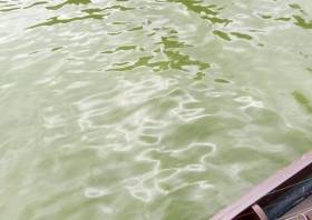
Last July pet owners were advised to be vigilant over the presence of Cyanobacteria which has turned the waterway a soupy pea-green colour.
A previous outbreak in 2016 was connected with a number of dog deaths.
RTÉ News has more on the story HERE.
Toxic ‘Algae’ Threatens Wildlife In Killarney Lake
#Toxic - Pet owners have been advised to be vigilant over an outbreak of toxic blue-green ‘algae’ in a Killarney lake, as The Irish Times reports.
Lough Leane has been signposted by Kerry County Council over the presence of Cyanobacteria that has turned the waters a soupy pea-green colour.
A number of dogs died after exposure to the bacteria during a previous bloom on the lake shore in 2016.
Suspected similar cases have also been reported at Lough Mask as well as waterways further east, including Ballymore Eustace on the River Liffey.
Meanwhile, scientists at the Galway-Mayo Institute of Technology are preparing to use drones to test the water quality of lakes on the West Coast.
GMIT’s Marine and Freshwater Research Centre has secured €132,000 in funding from the EPA for the scheme that will allow for real-time feedback of camera images and data.
Licensed drone pilots will work with lake biologists and water scientists on the two-year project, part of Ireland’s mandate under the EU’s Water Framework Directive.
The Irish Times has more on this story HERE.


