Menu

Ireland's sailing, boating & maritime magazine

Dublin Bay Boating News and Information

Displaying items by tag: Stormont

Three Sinn Féin MLAs have brought a motion to the newly restored Stormont Assembly for action to save Lough Neagh from its pollution crisis, as The Irish Times reports.

MLA for North Antrim, Philip McGuigan described the situation on the lough as an “ecological catastrophe”.

“The work of saving Lough Neagh and repairing the damage to its ecology and environment and that of its tributaries and surrounding land must be a top priority for the Executive in the time ahead,” he told the Assembly on Tuesday (13 February).

The motion comes on the heels of last summer’s spate of toxic blue-green algae blooms, which caused the deaths of numerous pets and was blamed for the collapse of the lough’s renowned native eel fishery.

Untreated wastewater and agricultural run-off — not to mention climate change, invasive species such as the zebra mussel, and political inaction due to the collapse of the Northern Ireland Executive — have been singled out as reasons behind the current crisis.

The Irish Times has more on the story HERE.

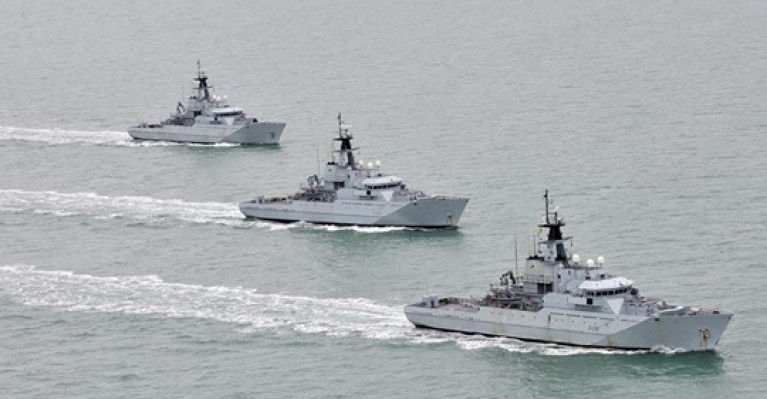
The UK's Royal Navy will only deploy vessels to protect fishing waters surrounding Northern Ireland if requested to do so by the Stormont Executive, the British Government has said.

It was revealed the UK had "run live exercises" that involve scrambling "naval vessels to respond to threats of illegal fishing in our soon-to-be sovereign waters" as part of efforts to prepare for a no-deal Brexit.

The Ministry of Defence (MoD) confirmed that four Royal Navy gunboats have been placed on stand-by to guard British waters from EU trawlers if there is no agreement as Afloat reported yesterday.

Reports also suggest that UK Government ministers are considering beefing up Navy powers in legislation to authorise them to board and arrest fishermen found to be contravening post-Brexit rules.

However, the MoD told the Belfast Telegraph that gunships will only be deployed around Northern Ireland if requested to do so.

More details from the newspaper here.

Published in Fishing

#Angling - The use of prawns and shrimp as bait in salmon angling could be banned in Northern Ireland under proposed restrictions on salmon and sea trout fishing, as Farming Life reports.

Aside from the bait regulations, Stormont is also putting forward a ban on commercial salmon netting and the introduction of a catch-and-release scheme for sport anglers in an effort to reverse dwindling salmon numbers in Ulster's inland waterways.

The moves come following an earlier voluntary ban on offshore salmon fishing in an effort to bolster wild salmon stocks which were last year feared to be "around dodo levels".

Similar restrictions were proposed this year for the River Suir - although anglers in Enniscorthy won support from Inland Fisheries Ireland last year in their call to lift a shrimp bait ban on their downstream fishery on the River Slaney.

Ulster Angling Federation chair Jim Haughey has urged angling club officials across Northern Ireland to study the consultation document published by the Department of Culture, Arts and Leisure with a view to making informed submissions on the proposed changes.

Farming Life has much more on the story HERE.

Published in Angling
Hundreds of schoolchildren protested at Stormont last week to call for new laws to protect Northern Ireland's coastal waters, the Belfast Telegraph reports.
The group handed a petition with 4,000 signatures to Environment Minister Alex Attwood urging the introduction of a Marine Bill which would provide special marine conservation zones and restrict harmful maritime activities.
At present, Northern Ireland is the only part of the UK with no legal safeguards for the protection of its coastline.
The Northern Ireland Marine Task Force, which is heading the campaign, says "over-reaching legislation" is needed to preserve the North's marine wildlife and plantlife habitats.
The Belfast Telegraph has more in the story HERE.

Hundreds of schoolchildren protested at Stormont last week to call for new laws to protect Northern Ireland's coastal waters, the Belfast Telegraph reports.

The group handed a petition with 4,000 signatures to Environment Minister Alex Attwood urging the introduction of a Marine Bill which would provide special marine conservation zones and restrict harmful maritime activities.

At present, Northern Ireland is the only part of the UK with no legal safeguards for the protection of its coastline.

The Northern Ireland Marine Task Force, which is heading the campaign, says "over-reaching legislation" is needed to preserve the North's marine wildlife and plantlife habitats.

The Belfast Telegraph has more in the story HERE.

Published in Coastal Notes

Dublin Bay

Dublin Bay on the east coast of Ireland stretches over seven kilometres, from Howth Head on its northern tip to Dalkey Island in the south. It's a place most Dubliners simply take for granted, and one of the capital's least visited places. But there's more going on out there than you'd imagine.

The biggest boating centre is at Dun Laoghaire Harbour on the Bay's south shore that is home to over 1,500 pleasure craft, four waterfront yacht clubs and Ireland's largest marina.

The bay is rather shallow with many sandbanks and rocky outcrops, and was notorious in the past for shipwrecks, especially when the wind was from the east. Until modern times, many ships and their passengers were lost along the treacherous coastline from Howth to Dun Laoghaire, less than a kilometre from shore.

The Bay is a C-shaped inlet of the Irish Sea and is about 10 kilometres wide along its north-south base, and 7 km in length to its apex at the centre of the city of Dublin; stretching from Howth Head in the north to Dalkey Point in the south. North Bull Island is situated in the northwest part of the bay, where one of two major inshore sandbanks lie, and features a 5 km long sandy beach, Dollymount Strand, fronting an internationally recognised wildfowl reserve. Many of the rivers of Dublin reach the Irish Sea at Dublin Bay: the River Liffey, with the River Dodder flow received less than 1 km inland, River Tolka, and various smaller rivers and streams.

Dublin Bay FAQs

There are approximately ten beaches and bathing spots around Dublin Bay: Dollymount Strand; Forty Foot Bathing Place; Half Moon bathing spot; Merrion Strand; Bull Wall; Sandycove Beach; Sandymount Strand; Seapoint; Shelley Banks; Sutton, Burrow Beach

There are slipways on the north side of Dublin Bay at Clontarf, Sutton and on the southside at Dun Laoghaire Harbour, and in Dalkey at Coliemore and Bulloch Harbours.

Dublin Bay is administered by a number of Government Departments, three local authorities and several statutory agencies. Dublin Port Company is in charge of navigation on the Bay.

Dublin Bay is approximately 70 sq kilometres or 7,000 hectares. The Bay is about 10 kilometres wide along its north-south base, and seven km in length east-west to its peak at the centre of the city of Dublin; stretching from Howth Head in the north to Dalkey Point in the south.

Dun Laoghaire Harbour on the southside of the Bay has an East and West Pier, each one kilometre long; this is one of the largest human-made harbours in the world. There also piers or walls at the entrance to the River Liffey at Dublin city known as the Great North and South Walls. Other harbours on the Bay include Bulloch Harbour and Coliemore Harbours both at Dalkey.

There are two marinas on Dublin Bay. Ireland's largest marina with over 800 berths is on the southern shore at Dun Laoghaire Harbour. The other is at Poolbeg Yacht and Boat Club on the River Liffey close to Dublin City.

Car and passenger Ferries operate from Dublin Port to the UK, Isle of Man and France. A passenger ferry operates from Dun Laoghaire Harbour to Howth as well as providing tourist voyages around the bay.

Dublin Bay has two Islands. Bull Island at Clontarf and Dalkey Island on the southern shore of the Bay.

The River Liffey flows through Dublin city and into the Bay. Its tributaries include the River Dodder, the River Poddle and the River Camac.

Dollymount, Burrow and Seapoint beaches

Approximately 1,500 boats from small dinghies to motorboats to ocean-going yachts. The vast majority, over 1,000, are moored at Dun Laoghaire Harbour which is Ireland's boating capital.

In 1981, UNESCO recognised the importance of Dublin Bay by designating North Bull Island as a Biosphere because of its rare and internationally important habitats and species of wildlife. To support sustainable development, UNESCO’s concept of a Biosphere has evolved to include not just areas of ecological value but also the areas around them and the communities that live and work within these areas. There have since been additional international and national designations, covering much of Dublin Bay, to ensure the protection of its water quality and biodiversity. To fulfil these broader management aims for the ecosystem, the Biosphere was expanded in 2015. The Biosphere now covers Dublin Bay, reflecting its significant environmental, economic, cultural and tourism importance, and extends to over 300km² to include the bay, the shore and nearby residential areas.

On the Southside at Dun Laoghaire, there is the National Yacht Club, Royal St. George Yacht Club, Royal Irish Yacht Club and Dun Laoghaire Motor Yacht Club as well as Dublin Bay Sailing Club. In the city centre, there is Poolbeg Yacht and Boat Club. On the Northside of Dublin, there is Clontarf Yacht and Boat Club and Sutton Dinghy Club. While not on Dublin Bay, Howth Yacht Club is the major north Dublin Sailing centre.

© Afloat 2020