


Displaying items by tag: Blueway

#barrowblueway – Waterways Ireland in partnership with Carlow, Kilkenny, Kildare and Laois County Councils and LEADER Companies is proposing to develop a Barrow Blueway, a 112km long shared-use trail for local people and visitors to enjoy along the route of the Barrow Way-Marked Way.
Following on from a number of studies and reports commissioned by various authorities including Waterways Ireland, the Local Authorities, LEADER Partnership Companies and Fáilte Ireland a series of interventions and programmes have been agreed and are being implemented by the agencies both collectively and individually. One such initiative is the Barrow Blueway.
The Barrow River and Barrow Line of the Grand Canal are waterway corridors of National and International importance and spectacular recreation and leisure amenities. Both the river and canal support a myriad of sustainable activities and sustain a rich and diverse built and natural heritage. It is the intention of Waterways Ireland to develop the existing trackway along the Barrow Line of the Grand Canal and Barrow River as a 112km Blueway. The Blueway would support a myriad of recreation activities, help grow and develop business along the length of the Barrow Blueway. The proposal entails the upgrading of the existing trackway to allow a multi use shared leisure route connecting Lowtown in Co. Kildare to St. Mullins in Co. Carlow, travelling through Lowtown, Rathangan, Monasterevin, Athy, Carlow, Leighlinbridge, Bagenalstown, Goresbridge, Graiguenamanagh and St Mullins.
Éanna Rowe, Head of Marketing & Communications, Waterways Ireland confirmed "Waterways Ireland is delighted to have progressed the Barrow Blueway proposal to the point where we now have meaningful information to share. We look forward to the Public Information Evenings where local businesses, activity providers, clubs, associations and all interested parties can come and view the proposals, examine design options and engage with our staff. We welcome all feedback and indeed will consider it as plans are finalised for this exciting new recreation and tourism initiative. "
The project is currently at design stage with tailored surface finishes to be employed to ensure a durable and fit for purpose trail in accordance with National Trails Office Guidance. This surfacing will not only improve accessibility but provide a more robust surface that will be able to better withstand footfall and traffic. Whilst it is proposed to employ a compacted stone and dust surface, a reinforced grass solution may be used in sensitive locations as guided by environmental requirements to preserve the grassy surface so valued by many people.
Carlow County Council Spokesman stated " In the context of progressing the economic and social development of the county, Carlow County Council is open to exploring and considering all recreational and tourism products, which may have a positive impact for the county, region and country, being mindful of the importance of its obligation to protect and enhance the environment and quality of life for all who live in, work in or visit the county".
Environmental studies have been commissioned including an Appropriate Assessment, given the route is partly within an SAC, and an Environmental Impact Assessment. These reports will be informed by detailed ecological assessments commissioned by Waterways Ireland ensuring the design of the Blueway is led by the baseline ecology present along the corridor.
Kilkenny Director of Services John Mc Cormack stated "Kilkenny County Council is supportive of this initiative which will maximise the tourism and recreational potential of the River Barrow for the benefit of the local economies of Graiguenamanagh, Goresbridge and the South East region in general."
The Blueway brand which Waterways Ireland has developed in conjunction with the National Trails Office, Fáilte Ireland and Canoeing Ireland, will also be used to promote internationally, the special journeys which take place either on foot, bicycle or boat on shared use trails along Ireland's Inland Waterways. Walking, cycling and canoeing activities have been shown to be highly sustainable as people engage in low group numbers, all year round and require services and facilities similar to those readily available in the towns and villages along the Barrow Valley. The Barrow Blueway is ideally suited to belong to this brand and well- placed to add to the economic and social sustainability of its towns and villages.
Before progressing the project further, Waterways Ireland would like to invite interested parties from local communities, activity providers, accommodation and food establishments to view the designs, proposed route and take the opportunity to meet and speak to Waterways Ireland personnel and give feedback on the project.
join at the following locations
Carlow: 20th November 2-7pm in the Seven Oaks Hotel, Carlow
Killkenny: 21st November 2-7pm in the Scout Hall, Graiguenamanagh
Laois: 27th November 2-7pm in the Vicarstown Inn, Vicarstown
Kildare: 4th December 2-7pm in the Community Library, Athy.
If unable to come to any of the meetings, view the information online here and submit your feedback online.
Waterways Ireland is happy to receive feedback up until the 5th January 2015. At that point all the feedback submitted will be reviewed, appropriate amendments made and an application for planning permission submitted.
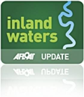
Walking the Shannon Blueway

#shannonblueway – Leitrim, Roscommon and Cavan have many kilometres of walking trails, looped, linear, long and short distance, all linked by one thing – the waterways. There are over 100km of water trails radiating from Carrick-on-Shannon which link these existing walking trails and to which Waterways Ireland has added National Loop Walking Trails along the Lough Allen Canal in partnership with Failte Ireland and Leitrim County Council.
There are three loops between Battlebridge and Drumhauver;
Battlebridge Drumleague loop 5km
Battlebridge Drumhauver loop 9km
Drumleague Drumhauver loop 4km
The Blueway builds on the huge potential provided by the existing waterway infrastructure. The potential is enhanced by the geography of the area offering hugely attractive rural towns and villages, such as Drumshanbo, Leitrim Village, Carrick-on-Shannon, Dromod and many others, closely located along the waterway that provide natural achievable looped trails, three heritage trails and access to the long distance routes of the Miners Way and the Leitrim Way. They are immensely attractive for short duration activity breaks.
The Blueway will enhance the choice available for visitor experience with the option of coming for an extended period to cruise the waterway or coming for a half day canoeing, cycling or walking break or any combination of activities. The new Shannon Blueway will offer a wide range of affordable pursuits in a safe family friendly environment.
The existing providers of commercial and recreation services in the region already recognise the significant opportunity the Shannon Blueway presents. Three new providers have opened in recent months.
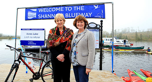
Shannon Blueway Launched with a Splash in Leitrim
#blueway – Minister Heather Humphreys TD, and actor & producer Carrie Crowley joined with over 300 walkers and paddlers to open the Shannon Blueway today in Drumshanbo, Co Leitrim.
As previously reported on Afloat.ie, the Shannon Blueway runs from Drumshanbo through Battlebridge and Leitrim Village to Carrick on Shannon. It includes 16.5km of water trail and over 10km of walking routes in three loops. The Shannon Blueway provides a range of recreational leisure activities such as walking, cycling, canoeing, fishing and cruising all linked by the waterways to local towns and villages.
Minister Heather Humphrey's stated "I am delighted to be launching this project here in Leitrim today. The Shannon Blueway has the potential to have a very positive impact on jobs and the regional economy. The Mayo Greenway, which is now in its 4th year of operation, has seen a jump in visitor numbers from 80,000 in 2011 to 300,000 in 2014. That means an extra €5 million was brought into the region. With the market for off road adventure tourism is growing here in Ireland and internationally, Leitrim is in a prime position to benefit from this trend.
The launch of the Blueway will allow local businesses can capitalise on an increase in demand for transport, equipment hire, accommodation and entertainment. I would like to commend Waterways Ireland for this initiative, which I have no doubt will have a very position impact on the region."
Carrie Crowley said "as a self-confessed blow-in to the area, the Shannon, the wonderful countryside and Leitrim people have provided me with a tranquil and inspirational place to work and home away from home .The only problem is, now our secret is out!"
The Shannon Blueway is the first of its kind in Ireland where a myriad of recreational activities have been developed and bundled together as a single or multiple visitor experience and tourism proposition. Waterways Ireland has, using the wonderful waterway assets, developed and built a canoe trail from Drumshanbo through Battlebridge and Leitrim Village to Carrick on Shannon. It has also developed a series of looped walks adjacent to the Lough Allen Canal with plans to expand those walks to Drumshanbo and Carrick on Shannon. At the same time Waterways Ireland is also developing a canoe trail from Leitrim Village along the 63km of the Shannon Erne Waterway with a walking and cycling trail also at an advanced stage of planning.
The Shannon Blueway is being delivered by Waterways Ireland in partnership of the National Trails Office, Canoeing Ireland, Leitrim County Council, Leitrim Tourism and Fáilte Ireland.
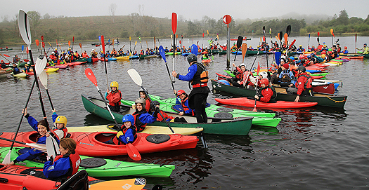
Minister Heather Humphreys TD, and WI Chief Executive Dawn Livingstone
Chief Executive Dawn Livingstone confirmed that partnership was the key to delivering the Shannon Blueway "Waterways Ireland has invested significantly in creating world beating facilities and services on the Shannon Navigation. Through our partnership with the National Trails Office, Canoeing Ireland, Leitrim Tourism and Leitrim County Council an outstanding multi-activity product has been built in the Shannon Blueway which is now being packaged by clubs and communities for their recreational activities and companies and organisations for domestic and international tourists. Partnership is key to delivering the future of the Shannon Blueway further into Leitrim, and indeed into Roscommon, Longford and Cavan."
The wider Shannon Blueway of which the Drumshanbo to Carrick on Shannon section is part, is at the heart of access to 100km of paddling area, 6 looped walks: 3 of which are on the canal towpath, two long distance walks and three heritage trails. The Shannon Blueway will ultimately provide access to 14 towns and services with each access point and town within an hours' paddling time.
300 paddlers joined the ShannonBlueway launch
Waterways Ireland and Leitrim Co Co will shortly be examining the possibility of providing a connection from the jetties at Acres Lake to the canal towpaths and also to complete the walking/cycling connection to Carrick-on-Shannon, and up the Shannon-Erne Waterway.
Waterways Ireland Blueway Canoe Trail Launch

#blueway – Waterways Ireland advises masters and owners that the Waterways Ireland Blueway launch event will take place on Sat 11th October a large fleet of canoeists will assemble at Drumshanbo Lock at 1130hrs and proceed to Acres Lake for 1200hrs for the formal launch of the Waterways Ireland Blueway Canoe Trail. Thereafter the fleet will proceed downstream towards Leitrim Village to arrive by 1500hrs.
Masters should proceed at slow speed when approaching this stretch of waterway during the event and note any directions issued by the organisers and safety marshals controlling the event. Masters are reminded to keep their wash low to avoid upsetting canoes and other low freeboard craft associated with the event.


 shipyard building hall in north Devon, England, where the vessel is to operate for the UK’s Royal Navy at the main base in Portsmouth.")

 with his best mate, getting into battle mood in the North African desert during World War II of 1939-45. Anyone who gets along well with a Jack Russell terrier, while looking so very like superstar actor Liam Neeson before Neeson was born, must have had some redeeming features - even if he was a danger to all when partying in a new kitchen")


 for the new skiff and builder Patsy Whelan Jnr.")


 with his exuberant crew as they celebrate being overall winners of Howth Wave 2024")
