


Displaying items by tag: TechWorks Marine
TechWorks Marine Completes Oceanographic Survey for Clogherhead Wind Park for ESB and Parkwind
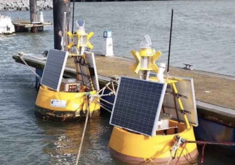
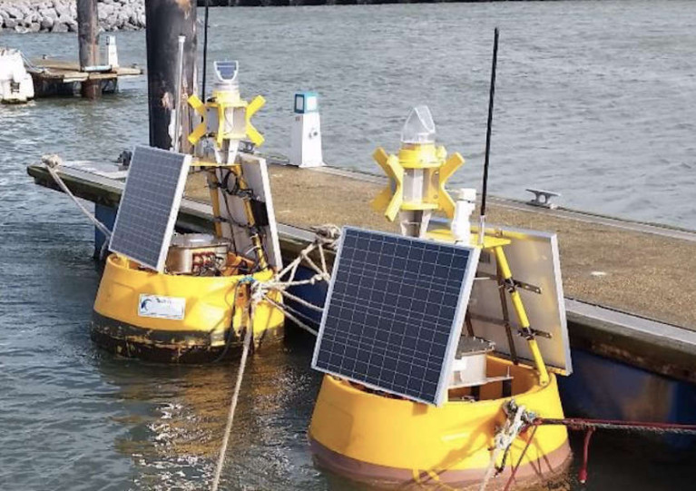
Metocean company TechWorks Marine has successfully completed a 12-month oceanographic campaign in the North Eastern Irish Sea for ESB and Parkwind at Clogherhead. The marine tech campaign involved the deployment of three metocean data buoys within the wind park area and along the export cable route, providing high-resolution data on sea state (currents and waves) and water quality.
The data collected in real-time was communicated using satellite and made available to clients through the secure CoastEye data platform. Additionally, Earth Observation satellite data was provided for some of the water quality parameters, which were validated by the metocean buoy measurements.
TechWorks Marine designed the metocean buoys to meet the clients' specific requirements, including the integration of all oceanographic sensors, vessel provision for deployment, servicing, and recovery, real-time ongoing data quality control, and the final data report, which included an intercomparison with an initial site model previously developed prior to the baseline survey.
Dr. Sinead McGlynn, Project Director at TechWorks Marine, expressed her delight in winning the contract through a competitive tender process. She emphasised the critical role of oceanographic surveys in the engineering design of offshore wind parks and expressed the company's eagerness to continue working on similar projects with ESB and Parkwind.
Mr. Conor Martin, Clogherhead Project Director, highlighted the significance of the Metocean survey in the development of the Clogherhead Offshore Wind Farm, emphasising the importance of the data in making informed decisions for the project's design and delivery.
The successful completion of the Metocean survey is a significant step in the development of the Clogherhead Offshore Wind Farm and comes at an exciting time for the Irish offshore wind energy sector.
Dublin's TechWorks Marine Secures Major Contract with European Space Agency to Advance Wind Energy Sector
TechWorks Marine, a leading marine data company based in Dublin has recently announced a significant contract worth €475,000 with the European Space Agency (ESA). The contract aims to expand the use of satellite data and products in Europe's renewable wind energy sector.
In light of Irish wind energy supplying a record 43% of all electricity in Ireland in March, TechWorks Marine says it is taking the lead on a project to identify the current information needs and best practices for utilizing satellite earth observation products in the wind energy sector. As a pioneer in earth observation products in Ireland, TechWorks Marine will collaborate with key stakeholders to establish how earth observation-derived information products can be effectively used in the wind industry's business processes. The project is of strategic importance to both Ireland and Europe and is expected to result in the development of a best practices guide for companies to identify suitable sites for new wind farms, gain a deeper scientific understanding of site conditions, and enable precise environmental compliance and monitoring activities.
Commenting on the project launch, Charlotte O’Kelly, Managing Director of TechWorks Marine, emphasised the company's extensive experience in the renewables sector and expressed the value of using satellite data to aid in both onshore and offshore site development throughout the entire life cycle of wind parks.
Furthermore, Dr. Zoltan Bartalis, Earth Observation Applications Engineer at the European Space Agency, acknowledged TechWorks Marine’s expertise in advocating for increased satellite data usage and emphasized the importance of consolidating the usage of satellite-based Earth Observation information for wind energy applications.
This project comes at a timely moment, as Dublin is set to host the Wind Europe Technology Workshop 2024 in early June. The event will bring together over 450 wind energy experts from across Europe to discuss the latest innovations and challenges within the sector.
With a solid track record in earth observation and marine data products, including eight contracts from the European Space Agency, TechWorks Marine continues to make significant strides in advancing the renewable energy sector.
Buoy Deployment for Metocean Survey of Proposed Clogherhead Offshore Wind Farm Site
Techworks Marine is deploying three surface buoys with single-point moorings for a metocean survey campaign at the site of the proposed Clogherhead Offshore Wind Farm.
It follows a geophysical survey campaign conducted by Alpha Marine this past summer, as previously reported on Afloat.ie.
These deployments are expected to be completed over a two-day period, at the next available weather window from Sunday 6 November, subject to weather and operational constraints.
Once deployed, the met ocean devices will remain on site for a period of up to 12 months.
The survey campaign will be undertaken within the proposed Clogherhead Offshore Wind Farm site, located some 10km from the Co Louth coast. Detailed coordinates and a map of the survey area are included in Marine Notice No 76 of 2022, attached below.
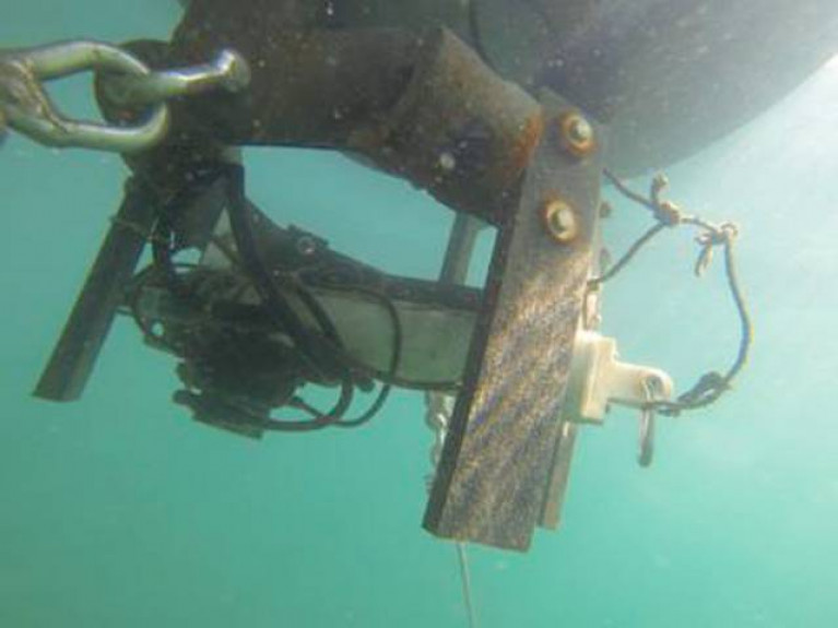
Three yellow buoys will be deployed, each with a hull diameter of 1.2m and a nominal freeboard of 0.7m. The buoys will display a St Andrew’s Cross day mark, and are fitted with a radar reflector and navigation light with a three nautical mile range, flashing a sequence of five flashes every 20 seconds.
Deployment operations will be conducted by the twin-hulled multi-cat work vessel MPV Skua (callsign 2GDE3).
During works, the vessel will be restricted in its ability to manoeuvre so all other vessels are requested to leave a wide berth during the deployment operations. Radio transmissions will be conducted with other seafarers to notify them of the operations.
TechWorks Marine Deploying Acoustic Doppler Current Profilers Off Kerry Coast for Irish Water Survey
TechWorks Marine plans to deploy four trawl-resistant bottom mounted acoustic Doppler current profilers (ADCP) frames in Castlemaine and Valentia off the coast of Co Kerry from this Monday 7 February.
Weather permitting, the Ocean Navigator (callsign EI018) will deploy the four trawl-resistant, bottom-mounted ADCPs frames — each of around one square metre in area — on the seabed for a minimum of one month and a maximum of two months, between this week and Monday 21 February.
They will be used to carry out water quality sampling surveys as well as vessel-mounted ADCP surveys at the same time as the deployments and these are tide and weather dependent and may cause a slight delay in the recovery of the seabed frames.
The ADCPs will be measuring currents through the water column at each location over the course of their month-long deployment. This data will be used to validate a hydrodynamic model being developed of the area for Irish Water.
There will be no surface marker during the extent of deployment so vessel traffic will not need to avoid the area but should be aware of its presence. Throughout operations, the Ocean Navigator will be displaying appropriate lights and shapes.
Details of the exact locations of the ADCP frames and other information for mariners are included in Marine Notice No 08 of 2022, which can be downloaded below.
TechWorks Marine has scheduled the deployment of three trawl-resistant acoustic Doppler current profilers (ADCPs) in Tralee Bay from next week.
The three bottom-mounted ADCP frames will be positioned on the seabed at various depths between Monday 1 and Saturday 13 November, weather depending.
If the deployment is delayed due to unsuitable conditions, then it will be carried out on the next viable tide and weather window.
Once deployed, the frames will be on the seabed for a minimum of one calendar month and a maximum of two months, weather permitting.
 Map showing the planned ADCP locations in Tralee Bay | Credit: TechWorks Marine
They are required to carry out water quality sampling surveys and vessel-mounted ADCP surveys at the same time as the deployments. As these are tide and weather dependent, they may cause a slight delay in the recovery of the seabed frames.
The frames will be deployed by the Whispering Hope (callsign EIAR8) which will be restricted in its ability to manoeuvre during this operation.
Vessels operating within this area are requested to keep their distance, maintaining a safety zone around the deployment vessel, and pass at minimum speed to reduce vessel wash.
Details of the exact locations of the ADCP frames and other information for mariners can be found in Marine Notice No 59 of 2021, which can be downloaded below.
Data Buoys for Oceanographic Monitoring of Fenit Harbour Set to Deploy in Tralee Bay
TechWorks Marine advises that it is set to deploy two marine monitoring buoys in Tralee Bay as part of environmental oceanographic monitoring for Fenit Harbour.
The DB 500 data buoys will be deployed tomorrow, Friday 26 March, weather depending, and will be in place until at least Friday 30 April, after which they will be retrieved by a chartered vessel.
A flat-bottomed aqua-cultural work barge named the Kerry Pearl will be deploying the buoys. During deployment and recovery, VHF Channels monitored will be Channel 14 (Fenit Harbour working channel) and Channel 16.
During the extent of deployment, vessel traffic will need to avoid the area.
Full details including exact location coordinates are included in Marine Notice No 14 of 2021, which can be downloaded below.
Techworks Marine Schedules Wave Buoy Deployment Off Wicklow
TechWorks Marine has scheduled the deployment of a wave buoy off the coast of Wicklow on Tuesday 8 December, weather allowing.
The buoy will be a yellow DB 500 and have a flashing light sequence of five flashes every 20 seconds, with a range of three nautical miles. The buoy will be marked with a St Andrew’s sross and radar reflector.
The wave buoy will be deployed at 53° 2' 35” N, -5° 41' 17” W by the the AMS Retriever (Callsign MEHI8) with an AIS system on board which has a provisional callsign of CWPW01.
If the deployment is delayed due to the weather, it will be carried out on the next viable tide and weather window. Once deployed, the wave buoy will remain on site for a minimum of six months.
Further details can be found in Marine Notice No 57 of 2020, a PDF of which is available to download below.
The Department of Transport, Tourism and Sport has been advised by TechWorks Marine that the lantern on the monitoring buoy in Killybegs Harbour has stopped working.
The buoy is part of environmental oceanographic monitoring for the Department of Agriculture, Food and the Marine in a project that began last September, and can be found at 54° 37.03' N, 008° 26.40' W.
The buoy is deployed on a dual mooring. Two small marker buoys indicate the locations of each of the buoy’s moorings. Vessel traffic will need to avoid this area.
The lantern will be repaired as soon as possible on the next viable tide and weather window. For further information contact TechWorks Marine at 01 236 5990.
Irish Firm Leads Satellite Coastal Research Project

#MARINE SCIENCE - An Irish marine science company will lead a new research project using satellites to monitor coastal outlets in Europe, as Silicon Republic reports.
TechWorks Marine, based in Dun Laoghaire, has won the contract to head up the European Space Agency's earth observation project in what is a first for any Irish company.
The business specialises in real-time marine data platforms, and in this project will be using its expertise to assist operators and developers of water treatment plants to help reduce their impact on the environment.
A main focus of the observation research will be the coastal effect of wastewater treatment in Donegal Bay.
TechWorks Marine MD Charlotte O'Kelly told Silicon Republic that improvements in sensor technology have prompted the development of satellite imagery of a high enough resolution to allow for close monitoring of coastal activity even from earth orbit.
Minister of State for Research and Innovation Sean Sherlock said the contract "clearly indicates that Irish SMEs have the capability and expertise to lead projects in this highly competitive sector".
Silicon Republic has much more on the story HERE.


 after conversion will be ready to meet future efficiency requirements when the works are due to be completed in 2025.")


 Bureau Veritas.")


 with his exuberant crew as they celebrate being overall winners of Howth Wave 2024")


