


Displaying items by tag: Donegal
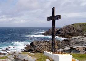
#MalinHead - The local man who died after a boat capsize off Malin Head in Donegal on Tuesday afternoon (17 July) lost his father in the same area four decades ago, it has emerged.
According to the Irish Independent, Gerry ‘Malin’ Doherty drowned close to where his father Paddy ‘Malin’ Doherty perished after slipping into the water from rocks in 1979.
Gerry Doherty and 16-year-old Thomas Weir died on Tuesday after Doherty’s 16ft cabin cruiser lost power and capsized less than 1,000 metres from shore.
Rescuers recovered a third individual in his late 40s — Dessie Keenan, a relative of Weir — who has since been released from hospital.
The Irish Independent has much more on the story HERE.
Two Dead After Fishing Boat Capsize Off Donegal
#Donegal - A man in his 60s and a teenage boy have died after the fishing boat they were on capsized off Malin Head in Donegal yesterday afternoon (Tuesday 17 July).
As Independent.ie reports, it’s believed the vessel got into difficulty just minutes after setting off from Malin Pier, with three on board, around midday.
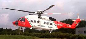
Tourists staying locally raised the alarm around 4pm after hearing cries for help, and a major search and rescue operation was launched immediately.
The teenager and a man in his 50s — both believed to be from Derry — were swiftly recovered, though the 16-year-old boy later died in hospital. The man in his 50s was also hospitalised and was said to be in a stable condition last night.
The body of the third person, a man in his 60s, was recovered on the shoreline before 6pm. He has been named locally as Gerry Doherty of nearby Carndonagh.
Independent.ie has more on the story HERE.
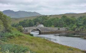
Tory Islanders Agree To New Passenger Ferry Deal
#IslandNews - Residents of Tory Island have voted in favour of a compromise proposal in their dispute with the State over a new ferry contract.
As previously noted on Afloat.ie, people living on the island off the Donegal coast feared the loss of their community with the planned introduction of a new ferry service that they argued was unsuitable for their needs.
But as The Irish Times reports, islanders have agreed in the majority to back a report presented to them on Friday (23 March) by mediator Pól Ó Gallchóir, and which also recommends a full departmental review of island transport around the Irish coast.
The revised proposal would see Tory Island get a new 12-passenger fast ferry alongside the 40-year-old Queen of Aran, the latter of which begins operation on the 15m route to the mainland next weekend.
Also recommended in the report is increasing the annual window for cargo runs and extending the HSE helicopter service over the winter months.
The Irish Times has more on the story HERE.
Arranmore Lifeboat Tows Crabbing Boat To Safety
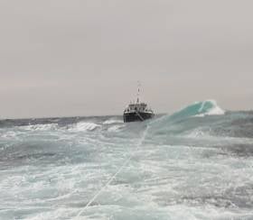
#RNLI - Arranmore RNLI was called to give assistance to a crabbing boat which got into difficulty off Arranmore on Tuesday (19 September).
The all-weather lifeboat was alerted at 4pm when the 60-tonne, 15m vessel with four crew on board suffered engine failure 35 miles northwest of Arranmore off the Donegal coast.
Weather conditions at the time were moderate with south, south east winds, Force 6-7 and a 3-4m swell.
When the lifeboat reached the crabbing boat, the crew secured a tow rope and the fishing vessel was towed to the safety of Burtonport harbour.
Arranmore RNLI coxswain Jimmy Early said: “This was a textbook rescue with favourable weather conditions and experienced fishermen who knew exactly what action to take in an emergency, they did all the right things to effect their rescue.”
#Marinas - Minister of State Joe McHugh will officially open the new €1.3 million Bunagee Marine Development on the Inishowen Peninsula tomorrow afternoon (Friday 9 June).
The new safe haven for coastal cruisers, including a breakwater and pontoons to accommodate 15 vessels, was developed by Donegal County Council as part of the major cross-border project Sail West.
It also forms part of a county-wide strategy to grow Donegal’s necklace of coastal tourism infrastructure and promote the county as a top marine destination in Europe, under the MalinWaters brand shared with Sligo, Northern Ireland’s maritime counties and Western Scotland.
Ahead of the marina's official opening, Donegal County Council Cathaoirleach Terence Slowey said: “We have a wonderful marine tourism product here in Donegal and the new Bunagee Marine Development is a great addition to our existing infrastructure.
“Situated close to the beautiful village of Culdaff, Bunagee is an ideal base that will give visitors the opportunity to explore the Inishowen Peninsula and the county.”
Minister McHugh will attend the official opening at Culdaff on Friday 9 June at 2.30pm.
The project was funded by the European Union’s INTERREG IVA Cross-border Programme managed by the Special EU Programmes Body. It was constructed by Deane Public Works, and Doran Consulting was awarded the contract as the consultant engineers.
Innovative Fish Counter Opens On Donegal’s River Lackagh
#Angling - Sean Kyne TD, Minister of State with responsibility for Inland Fisheries, has officially opened a new fish counter facility in the designated spring salmon fishery on the River Lackagh.
The project, which was devised and delivered by Inland Fisheries Ireland, was completed in recent months and will provide important data for the future management of spring salmon, grilse and sea trout stocks for the River Lackagh catchment, which incorporates Lough Beagh, situated in Glenveagh National Park.
This major infrastructural project, which was funded under IFI’s Salmon Conservation Fund, includes installation of a crump weir, Logie fish counter and access road to the Lackagh River at Creeslough, Co Donegal.
The counter will provide verifiable, accurate data on the size, duration and timing of fish migration through the fishery.
The River Lackagh counter project was developed by IFI in response to closure of the River Lackagh salmon fishery in 2007, when scientific advice indicated that salmon stocks had fallen to below their conservation limit.
The salmon fishery remained closed to enable fish stocks re-build until 2013 when electrofishing surveys confirmed that juvenile salmon stocks had recovered sufficiently to allow for the re-opening of the salmon fishery on a ‘catch and release’ basis.
IFI says the new counter will be a valuable addition to its national suite of index counters and represents the organisation’s first counter on the north Donegal coast.
Minister Kyne said he is “delighted to officially open this fish counter which will help protect fish stocks in the area. Angling is a valuable asset to local communities here in Donegal. This development will help us ensure the sustainability of fish populations for future generations.”
IFI chief executive added: “This fish counter provides real time data on fish stocks in the fishery and allows us to adapt to changing stock levels. This is crucial both from a conservation and economic viewpoint as this fishery contains valuable wild fish populations.
“I would like to acknowledge all our partners in this project who recognised the importance of this project and worked with us to delivery this facility for the local area.”
Angling in Ireland currently contributes €836 million to the Irish economy annually, supporting upwards of 11,000 jobs which are often in rural and peripheral communities.
IFI’s National Strategy for Angling Development aims to ensure the sustainable development of the natural angling resource in a conservation focused manner. If realised, the strategy could help increase the economic contribution of angling by €53 million annually and support 18,000 jobs.
IFI collaborated with several partners on the River Lackagh project including Donegal County Council, the National Parks and Wildlife Service (NPWS) and ESB Networks. IFI also acknowledges the assistance of Creeslough & District Angling Association, owners Hillary Keegan and John Coyle and service providers WD Buchanan & Co Ltd, H Harkin Plan Hire Ltd and Source Civil Ltd.
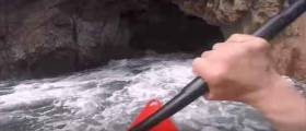
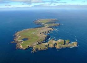
This is Umfin Island, which lives 3 km west of Gweedore, Donegal and is uninhabited except for a couple of thousand ground nesting sea birds. The short film shows Iain Miller paddling through a 300–metre sea cave tunnel which passes right through the middle of the island from the Atlantic to the Gweedore side. In the centre of the tunnel is a 30m section which is in complete darkness and is guarded at either end by a constriction or narrowing in the cave walls, these narrowings are very tidal.
Umphin (Umfin or Iompainn) Island is a small uninhabited island living on the sea ward side of Inishmeane and just to the North of the much better known Gola Island. The island sits approximately 3km from mainland Donegal and is normally surrounded by mildly tetchy seas. Umphin is home to a ground nesting colony of several thousand sea birds and sees very few visitors of the human kind. Access to the island is by boat or if you are feeling Olympic by swim. There is no regular ferry service to the island and leisurely sea kayak paddle is an excellent way to approach and visit the island.
On the landward (Donegal mainland) side of Umphin there is a perfect natural harbour and shelved landing beach between mainland Umphin and the outlaying Tornacolpagh Island. The channel between the islands provides a very shelter landing spot which at low tide allows you to walk between the island as the sea retreats.
The rest of the island's coastline is very exposed to every ripple of oncoming sea motion from all directions south west through to north and is effectively guarded by sea cliffs for most of it's circumference.
Fifty Years Of Irish Surfing Celebrated In Rossnowlagh Next Weekend
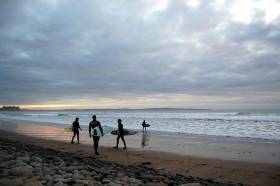
#Surfing - Fifty years of Irish surfing will be celebrated in Rossnowlagh this month, as the Donegal Democrat reports.
A gala dinner during the Rossnowlagh Intercounties next weekend (15-16 October) will mark five decades since the formation of what was then the Surf Club of Ireland by Kevin Cavey, who was influenced by images of surfing in a Reader’s Digest magazine.
Cavey himself inspired the legendary Britton clan in Rossnowlagh, and the family’s Sandhouse Hotel soon became a focal point for Irish wave-riding.
Fast-forward to today and Ireland, and the North West in particular, is among the world’s stop surfing destinations, producing world-class talent such as women’s surf pioneer Easkey Britton.
But the Irish Surfing Association’s golden jubilee dinner at the Sandhouse next Saturday 15 October is an opportunity to look back fondly at memories and happenings from Irish surfing’s earliest days. Irish Surfing has more HERE.
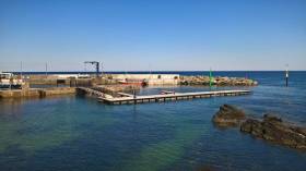
Minister Creed Launches €3m Small Craft Harbour & New Fishmeal Plant
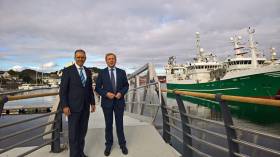
Minister for Agriculture, Food and the Marine Michael Creed TD today launched two new major marine projects in Killybegs, Co. Donegal. The first of these was the redevelopment of the United Fish Industries (UFI) fishmeal plant which has just been completed at a cost of €30million. The second was the new Killybegs Small Craft Harbour built at a cost of €2.9million as reported by Afloat.ie in March here.
Minister Creed said that “I was delighted to be here today to officially launch the redevelopment of the UFI fishmeal plant in Killybegs. This is a very significant investment by the company and is a major vote of confidence in Killybegs and the Irish seafood industry. The board of Pelagia, the parent company of UFI, have shown their serious long term commitment to seafood in Ireland and it was a pleasure to meet them here today to be able to congratulate them in person.”
Minster Creed also officiated at the launch of the new Killybegs Small Craft Harbour. Minster Creed said at the launch that “This new harbour, fully funded by the State, is a first class facility capable of accommodating 63 boats ranging up to 15 metres in length with one berth capable of accommodating larger vessels in excess of 20 metres long. This is great development for Killybegs Harbour and will complement the existing world class facilities in place for our large fishing vessels.”
During his visit to Killybegs, Minster Creed also had meetings with the Killybegs Fishermens Organisation, the Irish Fish Processors & Exporters Association and the Inver Traditional Herring Fishermen to discuss a range of fisheries issues.
Separately and accompanied by Minister of State Joe McHugh TD, Minister Creed met with a number of local farming representatives.
Body Recovered After Car Plunges Off Donegal Pier
#Kerrykeel - The body of a woman whose car went of a pier near Kerrykeel in Co Donegal yesterday has been recovered from the water, as Independent.ie reports.
A post-mortem was set to be carried out in Letterkenny General Hospital on the 36-year-old woman, who was last seen in Kerrykeel just minutes before the incident around 12.30pm.
It has since emerged that a local teenager attempted to rescue the woman from the car after it plunged off the pier, and was subsequently treated for shock.
Independent.ie has more on the story HERE.


 Michael Murphy Schull Harbour Sailing Club (SHSC), Eric Coogan Heineken Ireland, Mark Murphy, Commodore SHSC, Jack Allen SHSC, Carmel O'Regan SHSC, Cornelious Ndlovu, Schull Harbour Hotel Operations Manager and Derval Murphy SHSC")

