Menu

Ireland's sailing, boating & maritime magazine

Inland afloat headers


Displaying items by tag: Isle of Man

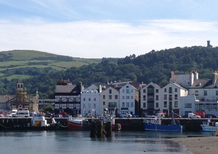
Ferry passenger numbers carried by Isle of Man Steam Packet Company for last year, were the highest for 16 years.

Figures from the operator which has routes between Douglas and Heysham, Belfast, Dublin and Liverpool, reveal more than 623,000 passengers were carried on board in 2023. In addition last year there were over 196,000 vehicles loaded on and off for onward transport.

Also last year, in August, the Steam Packet’s new flagship, Manxman entered service on the core Douglas-Heysham route in which traffic figures from the new ferry were also included for last year.

The Isle of Man-England route is the only year-round operated service of the company’s four route network which also connect Northern Ireland and the Republic.

Statistics also show the highest numbers seen by the Steam Packet took place in 2007, the year that marked the TT's 100th anniversary.

After the challenges faced during the Covid pandemic, the Manx Government owned company has since seen that the numbers reflect a "positive trend" forward.

There was a rise in 2023 of more than 27,000 passengers when compared to the previous year and an increase of more than 3,500 vehicles than in 2022.

The previous highest traffic figures were during that TT centenary year, when the Steam Packet carried 632,942 passengers and 197,745 vehicles.

More from BBC News also on Merseyside developments.

Published in Ferry

Dundalk is where a team of divers from the Isle of Man visited the Co. Louth port town so to bring the bell of the steam ship flagship, S.S. Dundalk back to a grateful town.

As EnergyFM reports, divers of Discover Diving based in Port, St. Mary, on the Manx south coast, were guests of honour of Dundalk’s Louth County Museum.

Artefacts of the Glasgow built flagship of the Dundalk and Newry Steam Packet Company were retrieved from the wreck. They consist the bell and its wrought-iron hanger, a porthole and a washbasin which were handed over to the county museum.

As Afloat previously reported, S.S. Dundalk during WWI was attacked on 14th October, 1918 by a German submarine during a return trip from Liverpool’s Collinwood Dock to Dundalk. The cargo ship's main trade was cattle, produce and also the carriage of passengers. 

The torpedo attack led to the sinking of the 234ft long merchant ship and claimed 21 people. Only 12 survived, some of which were brought to Douglas from the incident that took place just weeks before the end of World War 1 and of the crew, they mostly were local to the Dundalk area.

On the 100th anniversary of the sinking, a committee of descendants of the crew, travelled to the Isle of Man to unveil a memorial clock on the Castletown River waterfront. The clock is in memory to those who tragically lost their lives.

For more,Energy FM reports more on the return of the ship's bell.

Also in the centenary year, Afloat reported of a ceremony held on board the Isle of Man Steam Packet's Mannanan which saw the fast ferry take a special detour to the wreck site some 60 miles offshore.

On the 92nd anniversary, the Dundalk Sub Aqua Club divers carried out a commemorative dive to the wreck site. The divers laid a plaque of remembrance which Dundalk town council had sponsored.

Published in Historic Boats

Far Shore Merchants has announced its sponsorship of the Peggy Round Mann Yacht Race which takes place on 3rd-4th June 2022 over the extended Jubilee weekend holidays.

The 65 nautical mile circumnavigation of the Isle of Man, organised by the Isle of Man Yacht Club, will start as usual from Port St Mary at 7 am with competitors given a 30-hour time limit to complete the course. It is open to any ballasted sailing vessel and is well-known amongst the sailing community for its challenges of tricky tidal conditions as well as unpredictable weather.

This year’s event has been renamed Peggy Round Mann Yacht Race after Far Shore Merchant’s popular brand, Peggy Dark Rum. The rum itself was named in honour of the Isle of Man’s most famous and oldest surviving wooden yacht which sailed the Manx seas in the 18th Century and has been linked to tales of mystery and intrigue in its past life.

Doug Hey, Co-Founder and Managing Director of Far Shore Merchants, said “We are thrilled to support the Round Mann Yacht Race, one of the key events in the Island’s sailing calendar. With many of our products having a nautical theme, it seemed a great opportunity – and a very apt way – to help a local sailing organisation continue a long-held tradition.

“We are looking forward to seeing a good entry on the day and will be following the race as it progresses. We’ll also be very happy to share a well-deserved tot of Peggy Dark Rum with competitors in the bar at the end of the race!”

Commodore of the Isle of Man Yachting Club Phil Hardisty said, “We are very grateful to Far Shore Merchants for sponsoring our 40th-anniversary race and for bringing their PR and marketing experience to the event.

“The Peggy Round Mann Race is unusual in today’s era of competitions as it is more of an offshore “sprint” with its 30-hour time limit. Tidal and weather conditions usually ensure that there is much for teams to consider as they navigate their way around the Island so it is an exciting prospect for yachtsmen and women.

“With the event taking place in the middle of this year’s TT Fortnight, as well over the Jubilee Bank Holiday weekend, we are looking forward to increased numbers of both competitors and spectators.”

For more information and to enter for the Peggy 40th Anniversary Round Mann Yacht Race, go here

Published in Isle of Man
Tagged under

Howth Yacht Club’s Cruising Group has planned its first cruise of the year, sailing to Ardglass in Northern Ireland and the Isle of Man from Thursday 19 to Saturday 21 May.

The club advises all interested parties to contact Susan Kavanagh directly, as the Cruising Group is always happy to welcome new members into the fold.

Ahead of that, the group’s first armada of 2022 will be to Lambay Island this coming Saturday 7 May.

Early risers can get a head start by registering for the Darkness Into Light sunrise sail in aid of Pieta House. Boats will leave the harbour for Ireland’s Eye at 5am alongside the pier walk from The Light House, HYC’s new pergola.

If you would like to sail but don't have a boat, get in touch with Susan Kavanagh, who will be happy to find you a seat for this special cause.

Published in Howth YC

Despite plans for a significant multi-million-pound investment in marine leisure in the Isle of Man, plans for a marina in Ramsey to be known as the 'marina at the crossroads of the Irish Sea' have met with significant objections.

As regular Afloat readers will know, Ramsey Marina Limited (“RML”) opened registration for expressions of interest for berths at the proposed site in February.

"The beach is a marine conservation area, a very sandy much loved free communal beach and is subject to fierce waves in the autumn/ winter months. 65,000 signed a petition opposing the plans", Ramsey Resident Ruth Gale told Afloat. 

"I appreciate the benefits that added tourism could bring to the town but not at the cost of one of the nicest public beaches on the island", she said.

A petition to save Ramsey South Beach and the Marine Nature Reserve from destruction has raised 65,000 signatures.

The petition, entitled ’Stop the Destruction of the Ramsey Bay Marine Nature Reserve’ was launched by Facebook group ’South Beach Ramsey - Save the Bay’, after it was discovered the marina proposal was due to be re-launched last year.

The Ramsey Marina proposal would see full-scale dredging of Ramsey Bay, with reclaimed land used for the construction of a housing estate and marina on the public beach.

According to a 2019 DEFA survey, it is home to many important species of fish and aquatic plants, including eel grass, which thrives in the area and is 35 more times effective at carbon capture than rainforest trees.

The plans would see the beach between the historic Queen’s Pier and the Stone Pier given to private development.

Another resident, Josephine Sebastian told Afloat "the overwhelming majority of the residents of Ramsey do not want this marina.  RML are proposing to build this abomination on most of the beautiful shallow sandy bay called south beach.
It’s the wrong place…in every sense". 

The petition is here

Published in Isle of Man
Tagged under

Ramsey Marina Limited (“RML”) to be known as the 'marina at the crossroads of the Irish Sea' has opened registration for expressions of interest for berths at the proposed Ramsey Bay Marina on the Isle of Man.

It's a welcome development given the Isle of Man lies at the epicentre of significant multi-million-pound investment in marine leisure by the Governments of Scotland, Ireland, Wales and Northern Ireland yet in terms of marine leisure facilities, the Island is conspicuous by its lack of similar investment.

Promoters say Ramsey Bay Marina will be a 24/7 all-weather marina located immediately to the south of the entrance to the historic port of Ramsey on the Isle of Man. It will have 400 berths with a minimum depth of 3m. The berths for larger vessels, up to a maximum of 25m, will have between 5 and 6m depth. RML plans to keep 20% of the berths set aside for visitors.

Located at the crossroads of the northern Irish Sea, Ramsey is ideally suited for cruising the coasts of England, Scotland and Ireland. The Isle of Man itself (the only whole nation to become a UNESCO Biosphere) provides a lovely cruising ground for visiting yachts, with many ports under a day’s sail from Ramsey. In addition, Ramsey is an ideal “stopping off” point for those yachts transiting the Irish Sea.

The overall investment in building the marina will be in the region of £100m, which includes roughly £50m to build the marina itself and the other £50m to cover the cost of building the associated mixed use commercial/residential development.

Ramsey Marina will have full amenities and access to repair and maintenance facilities, as well as a wide range of shops offering everything from chandlery to local artisan foods.

Alongside the marina will be a mixed-use residential/commercial development. The residential units will range from 1 bedroom apartments to 3-4 bedroom townhouses. These will be ideal pieds-à-terres for yachtsmen who would like to keep their vessels in Ramsey on a permanent basis.

Berthing fees will be on a par with other similar marinas in the Irish Sea.

The overall investment in building the marina will be in the region of £100m, which includes roughly £50m to build the marina itself and the other £50m to cover the cost of building the associated mixed use commercial/residential development.The overall investment in building the marina will be in the region of £100m, which includes roughly £50m to build the marina itself and the other £50m to cover the cost of building the associated mixed use commercial/residential development.

RML is also planning to set up the Island’s “National Maritime Sports Centre” which will apply for full accreditation with the RYA, British Canoeing and others to provide courses catering for beginners through to professional qualifications. Similar to other centres it will offer accommodation.

The marina will host a range of bars and restaurants in addition to those already in the town of Ramsey. It will also include a boutique hotel that will showcase the Island’s local food, including its world-renowned shellfish.

Further details of the proposed marina can be found at www.ramseymarina.com.

To register an interest in a berth, download and complete the form from the website. Once completed please submit to: [email protected]. Respondents will receive a formal acknowledgement of receipt of the forms by RML. Priority will be given strictly on a “first come, first served” basis.

Published in Isle of Man
Tagged under

A man has been jailed for four weeks on the Isle of Man after breaking coronavirus rules by riding a jet ski from Scotland to the island.

As Sky News reports, 28-year-old Dale McLaughlan — who had never before used a personal water craft — embarked on difficult crossing in rough conditions last Friday (11 December) to visit his partner, whom he met on the island in the Irish Sea while working as a roofer in September.

It’s understood McLaughlan took the drastic measure after he was twice denied a visitor’s permit to the island, which has implemented strict access rules for non-residents to control the pandemic.

However, the move has cost McLaughlan dearly as local police confronted him at the weekend while he was on a night out.

“He was wholly inexperienced in operating a jet ski,” the Isle of Man’s deputy high bailiff said. “He deliberately attempted to avoid detection and circumvent the entry regulations in place to protect the Isle of Man.”

Sky News has more on the story HERE.

Published in Jetski
Tagged under

The Isle of Man Ship Registry, which is one of the world's leading flag states, is set to launch the first ever seafarer welfare app designed by a ship registry.

Director of the Isle of Man Ship Registry Cameron Mitchell said the app is in the final stages of development and is set go live later this month. It will be available for free to around 11,000 seafarers sailing on more than 400 vessels under the Isle of Man flag.

Cameron, who served as a marine engineer at sea for 17 years with shipping lines including Maersk and Farstad, said the introduction of the app is being accelerated to tackle the immense challenges facing seafarers caught in the coronavirus pandemic.

“Safety is a fundamental pillar of our ethos as a high-quality flag state,” he said. “Even before Covid we recognised that something had to be done that delivered tangible results to help seafarers in the wilderness of the sea. We recognised that while there is support for seafarers in port, through the many brilliant chaplaincies and seafarer charities, the ‘weak link’ is support while at sea. I raised it at the Red Ensign Group and with the seafarer charity ISWAN and it was clear to us that the problem of seafarer mental health was becoming more acute, with seafarers spending more time alone in their cabin than ever before. The app has many functions but a key one is to provide social activities to get seafarers interacting more on-board to combat that isolation.”

Cameron said the IOM team has produced the app with maritime training organisation Tapiit, which will live stream its support and training sessions via the app.

“The app provides structured welfare support for the seafarer from nutritional advice to live interactive support sessions for mental health and fitness,” he said. “The feedback we are receiving from ship owners, both clients and non-clients, is really positive. Ship owners want to find new better ways to help and protect seafarers and want to embrace digital innovation. We hope this app will be a step forward for the industry and make a positive difference to many thousands of seafarers sailing under the Isle of Man flag.”

Cameron said he was introduced to Tapiit through Merseyside cluster organisation Mersey Maritime and said it is doing a brilliant job producing an app that gives such a breadth of support and functionality.

Richard Turner, CEO of Tapiit, which has offices in Liverpool and the Isle of Man, said the functionality of the app will be ground-breaking and range of services and support greater than any app currently available to seafarers.

“The Tapiit team is very excited to develop this crew welfare app with Cameron and his team at the Isle of Man Ship Registry,” he said. “From my time working at Shell and setting up Tapiit mental health, in particular, has always been the key problem area we have sought to tackle, so we are very much on the same wavelength as the IOM. Cameron has been very specific about what the IOM wants and when it goes live it will be the most comprehensive crew welfare app in the world. We also have a number of large organisations partnering the app, who will be announced soon, and as a result will be able to offer support, through the app, to crew worldwide both on-board ship and in port. The app is designed to make seafarers lives easier and happier so it is not a one-off download, it can be so useful and supportive it can become part and parcel of what seafarers do each day.”

Isle of Man Ship Registry background

Based in Douglas on the Isle of Man, the Isle of Man Ship Registry is one of the most respected registries in the world, consistently appearing at the top of the Paris MoU White List which ranks registries by performance.

The Isle of Man Registry is a quality flag of choice, a bespoke choice, that offers reliability and quality of service. The Registry is a Category One member of Red Ensign Group and an International Registry.

The Registry is run by a team of professionals dedicated to providing the very best in service. Backed by sophisticated electronic systems, it is able to register ships quickly and efficiently to suit all time zones and has on-line systems to smooth the processes for clients. An ISO 9001 and 14000 certified organisation, the Registry operates efficiently and consistently to exceed the standards expected of a modern Flag State.

With its in-house technical expertise, the Registry provides advice and regulatory oversight for the ships and yachts on the register, in a pragmatic and commercially sensitive manner. This partnership working and service-culture is what attracts clients to register more of their ships in the Isle of Man. Its portfolio of clients includes many of the world’s blue-chip ship owners and prestigious super yachts.

With 24/7 response and a growing network of surveyors in key locations, the Ship Registry provides a swift response to allow owners and managers to keep their ships operating in a competitive global industry. Backed by a Government which strongly supports the maritime sector, the Registry is operated on a cost-neutral platform, allowing its fee structure to be extremely competitive.

The Isle of Man Ship Registry offers high quality and superb service at a low cost. The Registry combines all fees into one annual fee payment whereas some open registries charge for almost all additional services. At the Isle of Man Ship Registry there is no annual tonnage tax based on size of ship, no inspection fee, no consular fee, no casualty investigation fees and it offers a discount for multi ship fleets as well as fee incentives for environmentally friendly ships.

This combination of quality service and a competitive fee structure ensures clients receive great value.

Published in Ports & Shipping

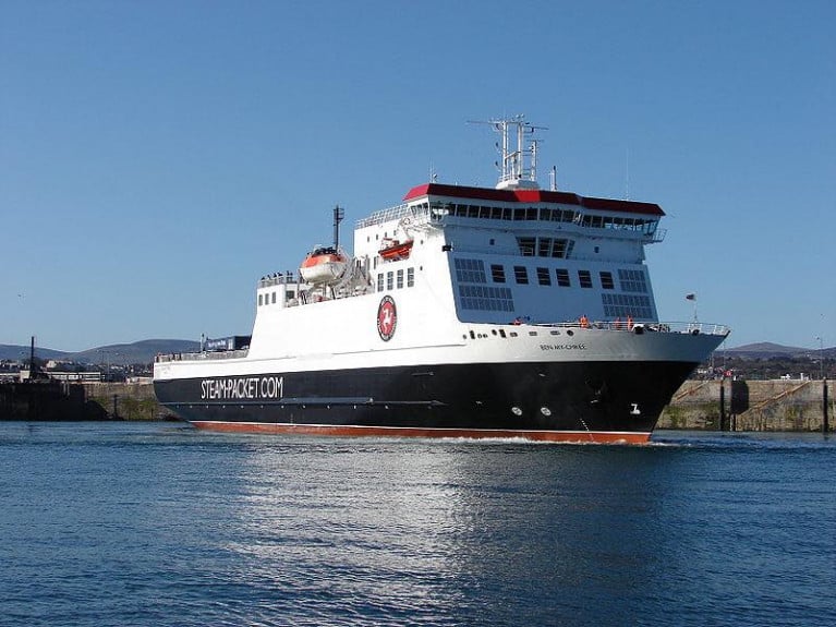
Ferry sailings to and from the Isle of Man have been updated as the Manx government announced it's easing travel restrictions.

As Manx Radio reported, Chief Minister Howard Quayle announced yesterday the Isle of Man is moving from stage five to four on its borders framework.

From Monday, 20 July, Manx residents can travel to the UK and beyond, as long as they self isolate for two weeks once they return.

The Isle of Man Steam Packet has therefore revised its schedule, running two daily sailings between Douglas and Heysham on the Ben-my-Chree on most dates from Friday, 24 July.

It will also provide a daily fast craft service to Liverpool on the Manannan from Fridays to Mondays, also starting from the 24 July.

Published in Ferry

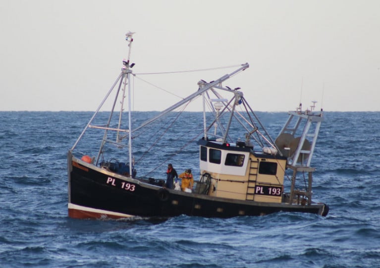
RNLI fishing safety manager Frankie Horne has urged the fishing community to avail of safety training that is on offer for their crews and to ensure that their safety equipment is up to date.

It comes after the skipper of a fishing vessel that sank late last year off the Isle of Man has attributed their rescue to the safety training the crew had undertaken previously and to their lifejackets, which were fitted with personal locator beacons (PLBs).

On the evening of 23 November last year, the fishing vessel Polaris suffered a catastrophic hull failure in the Irish Sea off the west coast of the Isle of Man.

The vessel sank so rapidly that the skipper only had time to send out a Mayday to the coastguard and other surrounding fishing boats before the vessel became submerged.

The coastguard immediately launched two RNLI lifeboats, from Port St Mary and Port Erin, and a rescue helicopter. However, it was a local fishing vessel, Lynn Marie, which arrived first on scene.

The skipper and a crew member from Polaris had been in the water for at least 15-20 minutes before help arrived.

The skipper of the Lynn Marie feared the worst on arriving at the scene as the Polaris had already gone below the water. The skipper stopped his engine to listen for the crew of the Polaris, which proved a wise decision as he heard two men in the water shouting. The Lynn Marie crew located them with a search light and recovered them from the water.

‘I can tell you that there is no doubt that the lifejackets saved our lives’

Commenting on the rescue, Horne said: “After speaking with Gordon Mills, the skipper of the Polaris, and the crew of Lynn Marie on their arrival at Peel, it was quite clear that this could have been a very different story had the crew of both vessels not acted so professionally.

“The crew had attended safety training and wore lifejackets fitted with personal locator beacons which had increased their chances of survival.”

Gordon Mills, skipper of Polaris, added: “At no time did I feel our lives were in danger due to our training and equipment.

“We had a policy of wearing lifejackets on the working deck since attending refresher training, where I was shown a film involving fishermen wearing their normal working clothes, being put through their paces in the RNLI Survival Centre Environmental Pool, both with and without lifejackets in cold water with wave movement whilst attempting to recover themselves.”

Mills added: “To see fishermen struggling in a controlled environment and only lasting a few minutes or in some cases a few seconds without the lifejacket makes you think about your own safety.

“I can tell you that there is no doubt that the lifejackets saved our lives. We wouldn’t have even been afloat for the crew of fishing vessel Lynn Marie to recover us from the water had we not been wearing them.

“I would encourage all fishermen to start wearing their lifejackets while on deck — you just never know when you might need it.”

Published in Fishing
Page 1 of 7

General Information on using Waterways Ireland inland navigations

Safety on the Water

All users of the navigations are strongly recommended to make themselves aware of safety on the water for whatever activity they are involved in and to read the advice offered by the various governing bodies and by:

The Dept. of Transport, Ireland: www.gov.ie/transport and The Maritime and Coastguard Agency, UK, The RNLI – Water Safety Ireland for information in terms of drowning prevention and water safety.

Registration of Vessels

All vessels using the Shannon Navigation, which includes the Shannon-Erne Waterways and the Erne System must be registered with Waterways Ireland. Only open undecked boats with an engine of 15 horsepower or less on the Shannon Navigation, and vessels of 10 horsepower or less on the Erne System, are exempt. Registration is free of charge.

Craft registration should be completed online at: https://www.waterwaysireland.org/online-services/craft-registration

Permits for use of the Grand and Royal Canals and the Barrow Navigation

All vessels using the Grand and Royal Canals and the Barrow Navigation must display appropriate valid Permit(s) i.e A Combined Mooring and Passage Permit (€126) and if not intending to move every five days, an Extended Mooring Permit (€152).

Permit applications should be completed online at: https://www.waterwaysireland.org/online-services/canal-permits

Passage on the Royal and Grand Canals – Dublin Area

For boat passage through the locks east of Lock 12 into / out of Dublin on either the Royal or Grand Canals, Masters are requested to contact the Waterways Ireland Eastern Regional Office (M-F 9.30am-4.30pm) on tel: +353(0)1 868 0148 or email [email protected] prior to making passage in order to plan the necessary lock-keeping assistance arrangements.

On the Grand Canal a minimum of two days notice prior to the planned passage should be given, masters should note that with the exception of pre-arranged events, a maximum of 2 boats per day will be taken through the locks, travelling either east or west.

Movements in or out of the city will be organised by prior arrangement to take place as a single movement in one day. Boaters will be facilitated to travel the system if their passage is considered to be safe by Waterways Ireland and they have the valid permit(s) for mooring and passage.

Newcomen Lifting Bridge

On the Royal Canal two weeks’ notice of bridge passage (Newcomen Lifting Bridge) is required for the pre-set lift date, and lock assistance will then also be arranged. A minimum of 2 boats is required for a bridge lift to go ahead.

Waterways Ireland Eastern Regional Office (Tel: +353(0)1 868 0148 or [email protected] ) is the point of contact for the bridge lift.

A maximum number of boats passing will be implemented to keep to the times given above for the planned lifts (16 for the Sat / Sun lifts & 8 for the weekday lifts). Priority will be given on a first come first served basis.

On day of lift, boaters and passengers must follow guidance from Waterways Ireland staff about sequence of passage under bridge & through Lock 1, and must remain within signed and designated areas.

Events Held on the Waterways

All organised events taking place on the waterways must have the prior approval of Waterways Ireland. This is a twelve week process and application forms must be accompanied with the appropriate insurance, signed indemnity and risk assessment. The application should be completed on the Waterways Ireland events page at :

https://www.waterwaysireland.org/online-services/event-approval

Time Limits on Mooring in Public Harbours

On the Shannon Navigation and the Shannon-Erne Waterway craft may berth in public harbours for five consecutive days or a total of seven days in any one month.

On the Erne System, revised Bye Laws state that: No master or owner shall permit a vessel, boat or any floating or sunken object to remain moored at or in the vicinity of any public mooring, including mooring at any other public mooring within 3 kilometres of that location, for more than 3 consecutive days and shall not moor at that same mooring or any other public mooring within 3 kilometres of that location within the following 3 consecutive days without prior permission by an authorised official.

Winter Mooring on the Shannon Navigation and Shannon Erne Waterway

Winter mooring may be availed of by owners during the period 1 Nov to 31 Mar by prior arrangement and payment of a charge of €63.50 per craft. Craft not availing of Winter Mooring must continue to comply with the “5 Day Rule”. Winter Mooring applications should be completed online at : https://www.waterwaysireland.org/online-services/winter-moorings-booking

Owners should be aware that electricity supply and water supply to public moorings is disconnected for the winter months. This is to protect against frost damage, to reduce running costs and to minimise maintenance requirements during the winter months.

Vessel owners are advised that advance purchasing of electricity on the power bollards leading up to the disconnection date should be minimal. Electricity credit existing on the bollards will not be recoverable after the winter decommissioning date. Both services will be reinstated prior to the commencement of the next boating season.

Smart Cards

Waterways Ireland smart cards are used to operate locks on the Shannon Erne Waterway, to access the service blocks, to use the pump-outs along the navigations, to avail of electrical power at Waterways Ireland jetties.

Berthing in Public Harbours

Masters are reminded of the following:

  • Equip their vessel with mooring lines of appropriate length and strength and only secure their craft to mooring bollards and cleats provided for this purpose.
  • Ensure the available berth is suitable to the length of your vessel, do not overhang the mooring especially on finger moorings on floating pontoon moorings.
  • Ensure mooring lines, electric cables and fresh water hoses do not create a trip hazard on public jetties for others users.
  • Carry sufficient fenders to prevent damage to your own vessel, other vessels and WI property.
  • Allow sufficient space between your vessel and the vessel ahead /astern (c.1m) for fire safety purposes and /or to recover somebody from the water.
  • Do not berth more than two vessels side by side and ensure there is safe access/egress at all times between vessels and onto the harbour itself.
  • Do not berth in such a way to prevent use of harbour safety ladders, slipways or pump-outs.
  • Do not allow the bow of your vessel to overhang the walkway of a floating mooring thus creating a hazard for others with an overhanging anchor or bow fendering.
  • Animals are not allowed to be loose or stray at any time.
  • Harbour and jetty infrastructure such as railings, power pedestals, fresh water taps, electric light poles, safety bollards, ladders etc are not designed for the purpose of mooring craft , they will not bear the strain of a vessel and will be damaged.
  • At Carrybridge on the Erne System, Masters of vessels are not permitted to use stern on mooring. Masters of vessels must use the mooring fingers for mooring of vessels and for embarkation / disembarkation from vessels.

Passenger Vessel Berths

Masters of vessels should not berth on passenger vessel berths where it is indicated that an arrival is imminent. Passenger vessels plying the navigations generally only occupy the berths to embark and disembark passengers and rarely remain on the berths for extended periods or overnight.

Lock Lead-in Jetties

Lead-in jetties adjacent to the upstream and downstream gates at lock chambers are solely for the purpose of craft waiting to use the lock and should not be used for long term berthing.

Vessel Wake

Vessel wake, that is, the wave generated by the passage of the boat through the water, can sometimes be large, powerful and destructive depending on the hull shape and engine power of the vessel. This wake can be detrimental to other users of the navigation when it strikes their craft or inundates the shoreline or riverbank. Masters are requested to frequently look behind and check the effect of their wake / wash particularly when passing moored vessels, on entering harbours and approaching jetties and to be aware of people pursuing other activities such as fishing on the riverbank.

Speed Restriction

A vessel or boat shall not be navigated on the Shannon Navigation at a speed in excess of 5 kph when within 200 metres of a bridge, quay, jetty or wharf, when in a harbour or canal or when passing within 100 metres of a moored vessel or boat.

Vessels navigating the Shannon-Erne Waterway should observe the general 5 kph speed limit which applies along the waterway. This is necessary in order to prevent damage to the banks caused by excessive wash from vessels.

Vessels navigating the Erne System should observe the statutory 5kt / 6mph / 10kph speed limit areas.

A craft on the Royal and Grand canals shall not be navigated at a speed in excess of 6km per hour.

A craft on the Barrow Navigation shall not be navigated at a speed in excess of 11km per hour except as necessary for safe navigation in conditions of fast flow.

Bank Erosion

Narrow sections of all the navigations are particularly prone to bank erosion due to the large wash generated by some craft. Masters are requested to be vigilant and to slow down to a speed sufficient to maintain steerage when they observe the wash of their craft inundating the river banks.

Unusual Waterborne Activity

Unusual waterborne vessels may be encountered from time to time, such as, hovercraft or amphibious aircraft / seaplanes. Masters of such craft are reminded to apply the normal “Rule of the Road” when they meet conventional craft on the water and to allow extra room to manoeuvre in the interest of safety.

Sailing Activity

Mariners will encounter large numbers of sailing dinghies from late June to August in the vicinity of Lough Derg, Lough Ree and Lower Lough Erne. Sailing courses are marked by yellow buoys to suit weather conditions on the day. Vessels should proceed at slow speed and with due caution and observe the rules of navigation when passing these fleets, as many of the participants are junior sailors under training.

Rowing

Mariners should expect to meet canoes and vessels under oars on any part of the navigations, but more so in the vicinity of Athlone, Carrick-on-Shannon, Coleraine, Enniskillen and Limerick. Masters are reminded to proceed at slow speed and especially to reduce their wash to a minimum when passing these craft as they can be easily upset and swamped due to their very low freeboard and always be prepared to give way in any given traffic situation.

Canoeing

Canoeing is an adventure sport and participants are strongly recommended to seek the advice of the sport’s governing bodies i.e Canoeing Ireland and the Canoe Association of Northern Ireland, before venturing onto the navigations.

Persons in charge of canoes are reminded of the inherent danger to these craft associated with operating close to weirs, sluice gates, locks and other infrastructure particularly when rivers are in flood and large volumes of water are moving through the navigations due to general flood conditions or very heavy localised precipitation e.g. turbulent and broken water, stopper waves. Shooting weirs is prohibited without prior permission of Waterways Ireland.

Canoeists should check with lockkeepers prior entering a lock to ensure passage is done in a safe manner. Portage is required at all unmanned locks.

Canoe Trail Network – "Blueways"

Masters of powered craft are reminded that a canoe trail network is being developed across all navigations and to expect more organised canoeing along these trails necessitating slow speed and minimum wash when encountering canoeists, rowing boats etc

Rockingham and Drummans Island Canals – Lough Key

It is expected that work on Rockingham and Drummans Island Canals on Lough Key will be completed in 2021. Access to these canals will be for non-powered craft only, eg canoes, kayaks, rowing boats.

Fast Powerboats and Personal Watercraft (Jet Skis)

Masters of Fast Powerboats (speed greater than 17kts) and Personal Watercraft (i.e.Jet Skis) are reminded of the inherent dangers associated with high speed on the water and especially in the confines of small bays and narrow sections of the navigations. Keeping a proper look-out, making early alterations to course and /or reducing speed will avoid conflict with slower vessels using the navigation. Personal Watercraft are not permitted to be used on the canals.

Towing Waterskiers, Wakeboarders, Doughnuts etc

Masters of vessels engaged in any of these activities are reminded of the manoeuvring constraints imposed upon their vessel by the tow and of the added responsibilities that they have to the person(s) being towed. These activities should be conducted in areas which are clear of conflicting traffic. It is highly recommended that a person additional to the master be carried to act as a “look-out” to keep the tow under observation at all times.

Prohibition on Swimming

Swimming in the navigable channel, particularly at bridges, is dangerous and is prohibited due to the risk of being run over by a vessel underway in the navigation.

Age Restrictions on operating of powered craft

In the Republic of Ireland, Statutory Instrument 921 of 2005 provides the legal requirements regarding the minimum age for operating of powered craft. The Statutory Instrument contains the following requirements:

- The master or owner of a personal watercraft or a fast power craft shall take all reasonable steps to ensure that a person who has not attained the age of 16 years does not operate or control the craft

- The master or owner of a pleasure craft powered by an engine with a rating of more than 5 horse power or 3.7 kilowatts shall take all reasonable steps to ensure that a person who has not attained the age of 12 years does not operate or control the craft.

Lifejackets and Personal Flotation Devices (PFDs)

Lifejackets and PFD’s are the single most important items of personal protective equipment to be used on a vessel and should be worn especially when the vessel is being manoeuvred such as entering / departing a lock, anchoring, coming alongside or departing a jetty or quayside.

In the Republic of Ireland, Statutory Instrument 921 of 2005 provides the legal requirements regarding the wearing of Personal Flotation Devices. The Statutory Instrument contains the following requirements:

- The master or owner of a pleasure craft (other than a personal watercraft) shall ensure, that there are, at all times on board the craft, sufficient suitable personal flotation devices for each person on board.

- A person on a pleasure craft (other than a personal watercraft) of less than 7 metres length overall shall wear a suitable personal flotation device while on board an open craft or while on the deck of decked craft, other than when the craft is made fast to the shore or at anchor.

- The master or owner of a pleasure craft (other than a personal watercraft) shall take all reasonable steps to ensure that a person who has not attained the age of 16 years complies with paragraph above.

- The master or owner of a pleasure craft (other than a personal watercraft), shall take all reasonable steps to ensure that a person who has not attained the age of 16 years wears a suitable personal flotation device while on board an open craft or while on the deck of a decked craft other than when it is made fast to the shore or at anchor.

- The master or owner of a pleasure craft (other than a personal watercraft) shall take all reasonable steps to ensure that a person wears a suitable personal flotation device, at all times while – (a) being towed by the craft, (b) on board a vessel or object of any kind which is being towed by the craft.

Further information is available at: http://www.irishstatutebook.ie/eli/2005/si/921/made/en/print

Firing Range Danger Area – Lough Ree

The attention of mariners is drawn to the Irish Defence Forces Firing Range situated in the vicinity of buoys No’s 2 and 3, on Lough Ree on the Shannon Navigation. This range is used regularly for live firing exercises, throughout the year, all boats and vessels should stay clear of the area marked with yellow buoys showing a yellow "X" topmark and displaying the word "Danger".

Shannon Navigation, Portumna Swing Bridge Tolls

No attempt should be made by Masters’ of vessels to pay the bridge toll while making way through the bridge opening. Payment will only be taken by the Collector from Masters when they are secured alongside the jetties north and south of the bridge.

Navigating from Killaloe to Limerick on the Shannon Navigation

The navigation from Killaloe to Limerick involves passage through Ardnacrusha locks, the associated headrace and tailrace and the Abbey River into Limerick City. Careful passage planning is required to undertake this voyage. Considerations include: lock passage at Ardnacrusha, water flow in the navigation, airdraft under bridges on Abbey River in Limerick, state of tide in Limerick

Users are advised to contact the ESB Ardnacrusha hydroelectric power station (00353 (0)87 9970131) 48 hours in advance of commencing their journey to book passage through the locks at Ardnacrusha. It is NOT advised to undertake a voyage if more than one turbine is operating (20MW), due to the increased velocity of flow in the navigation channel, which can be dangerous. To ascertain automatically in real time how many turbines are running, users can phone +353 (0)87 6477229.

For safety reasons the ESB has advised that only powered craft with a capacity in excess of 5 knots are allowed to enter Ardnacrusha Headrace and Tailrace Canals.

Passage through Sarsfield Lock should be booked on +353-87-7972998, on the day prior to travel and it should be noted also that transit is not possible two hours either side of low water.

A Hydrographic survey in 2020 of the navigation channel revealed that the approach from Shannon Bridge to Sarsfield Lock and the Dock area has silted up. Masters of vessels and water users are advised to navigate to the Lock from Shannon bridge on a rising tide one or two hours before High Tide.

Lower Bann Navigation

The attention of all users is drawn to the “Users Code for the Lower Bann”, in particular to that section covering “Flow in the River” outlining the dangers for users both on the banks and in the navigation, associated with high flow rates when the river is in spate. Canoeists should consult and carry a copy of the “Lower Bann Canoe Trail” guide issued by the Canoe Association of Northern Ireland. Users should also contact the DfI Rivers Coleraine, who is responsible for regulating the flow rates on the river, for advisory information on the flow rates to be expected on any given day.

DfI Rivers Coleraine. Tel: 0044 28 7034 2357 Email: [email protected]

Lower Bann Navigation – Newferry – No wake zone

A No Wake Zone exists on the Lower Bann Navigation at Newferry. Masters of vessels are requested to proceed at a slow speed and create no wake while passing the jetties and slipways at Newferry.

Overhead Power Lines (OHPL) and Air draft

All Masters must be aware of the dangers associated with overhead power lines, in particular sailing vessels and workboats with cranes or large air drafts. Voyage planning is a necessity in order to identify the location of overhead lines crossing the navigation.

Overhead power line heights on the River Shannon are maintained at 12.6metres (40 feet) from Normal Summer level for that section of navigation, masters of vessels with a large air draft should proceed with caution and make additional allowances when water levels are high.

If a vessel or its equipment comes into contact with an OHPL the operator should NOT attempt to move the vessel or equipment. The conductor may still be alive or re-energise automatically. Maintain a safe distance and prevent third parties from approaching due to risk of arcing. Contact the emergency services for assistance.

Anglers are also reminded that a minimum ground distance of 30 metres should be maintained from overhead power lines when using a rod and line.

Submarine Cables and Pipes

Masters of vessels are reminded not to anchor their vessels in the vicinity of submarine cables or pipes in case they foul their anchor or damage the cables or pipes. Look to the river banks for signage indicating their presence.

Water Levels - Precautions

Low Water Levels:

When water levels fall below normal summer levels masters should be aware of:

Navigation

To reduce the risk of grounding masters should navigate on or near the centreline of the channel, avoid short cutting in dog-legged channels and navigating too close to navigation markers.

Proceeding at a slow speed will also reduce “squat” effect i.e. where the vessel tends to sit lower in the water as a consequence of higher speed.

Slipways

Reduced slipway length available under the water surface and the possibility of launching trailers dropping off the end of the concrete apron.

More slipway surface susceptible to weed growth requiring care while engaged in launching boats, from slipping and sliding on the slope. Note also that launching vehicles may not be able to get sufficient traction on the slipway once the craft is launched to get up the incline.

Bank Erosion

Very dry riverbanks are more susceptible to erosion from vessel wash.

Lock Share

Maximising on the number of vessels in a lock will ensure that the total volume of water moving downstream is decreased. Lock cycles should be used for vessels travelling each way.

High Water Levels:

When water levels rise above normal summer level masters should be aware of:

Navigation

Navigation marks will have reduced height above the water level or may disappear underwater altogether making the navigable channel difficult to discern.

In narrow sections of the navigations water levels will tend to rise more quickly than in main streams and air draft at bridges will likewise be reduced.

There will also be increased flow rates particularly in the vicinity of navigation infrastructure such as bridges, weirs, locks etc where extra care in manoeuvring vessels will be required.

Harbours and Jetties

Due care is required in harbours and at slipways when levels are at or near the same level as the harbour walkways' as the edge will be difficult to discern especially in reduced light conditions. It is advised that Personal Flotation Devices be worn if tending to craft in a harbour in these conditions.

Slipways

Slipways should only be used for the purpose of launching and recovering of water craft or other objects from the water. Before using a slipway it should be examined to ensure that the surface has sufficient traction/grip for the intended purpose such as launching a craft from a trailer using a vehicle, that there is sufficient depth of water on the slipway to float the craft off the trailer before the concrete apron ends and that the wheels of the trailer do not drop off the edge of the slipway. That life-saving appliances are available in the vicinity, that the vehicle is roadworthy and capable of coping with the weight of the trailer and boat on the incline. It is recommended that slipway operations are conducted by two persons.

Caution to be Used in Reliance upon Aids to Navigation

The aids to navigation depicted on the navigation guides comprise a system of fixed and floating aids to navigation. Prudent mariners will not rely solely on any single aid to navigation, particularly a floating aid to navigation. With respect to buoys, the buoy symbol is used to indicate the approximate position of the buoy body and the ground tackle which secures it to the lake or river bed. The approximate position is used because of the practical limitations in positioning and maintaining buoys in precise geographical locations. These limitations include, but are not limited to, prevailing atmospheric and lake/river conditions, the slope of and the material making up the lake/river bed, the fact that the buoys are moored to varying lengths of chain, and the fact that the buoy body and/or ground tackle positions are not under continuous surveillance. Due to the forces of nature, the position of the buoy body can be expected to shift inside and outside the charted symbol.

Buoys and perches are also moved out of position or pulled over by those mariners who use them to moor up to instead of anchoring. To this end, mariners should always monitor their passage by relating buoy/perch positions with the published navigation guide. Furthermore, a vessel attempting to pass close by always risks collision with a yawing buoy or with the obstruction that the buoy or beacon/perch marks.

Masters of Vessels are requested to use the most up to date Navigation guides when navigating on the Inland Waterways.

Information taken from Special Marine Notice No 1 of 2023