Menu

Ireland's sailing, boating & maritime magazine

Inland afloat headers


Displaying items by tag: Strangford Lough

Portaferry Coastguard Rescue team was joined by the Bangor team for joint mud and water rescue training in Strangford Lough on Sunday, 28th February.

The Dorn at Ardkeen was the location for the mud training. The word Dorn, from the Gaelic word for narrow channel, refers to the channel which connects several sheltered bays to the Lough near Ardkeen on the eastern side of the Lough.

Cook Street Quay in Portaferry town was used for the water rescue training.

Mud rescue training in Strangford LoughMud rescue training in Strangford Lough

The Portaferry team said, "It is essential that we keep our skills up to the highest level possible, so when required to conduct a technical rescue, we provide a first-class service".

23rd February 2021

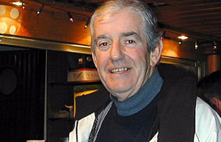
Brendan Sharvin 1925-2021

The death of Brendan Sharvin of Strangford village at the age of 95 has taken from among us a remarkable man who was a leading figure in the development of sailing and boating in the southern part of Strangford Lough, a very special man of enormous charm and ability who combined a lightning wit with genuine kindness.

Born into the family pub-grocery in the village near the quay – later it became the Cuan Bar, but everyone knew it as Sharvin's - he was a host and entertainer of world-class, a master joke and story-teller whose beautifully-timed and appropriate anecdotes well-matched anything that even the most humorous of his many customers could produce, such that he was renowned as the best raconteur in Lecale.

But there was a quietly serious side to him as well. He reckoned that continuing to develop the neighbourhood's recreational interaction with the sea was essential, and he was a leading light in encouraging racing with the local punts fitted with sails which made up in the initial "dinghy fleet" of the 1946-founded Strangford Sailing Club and was then active in the group which own-built a fleet of fourteen Wychcraft sailing dinghies in the late 1950s.

It's 1959, and the completion of Wychcraft sailing dinghy no 14 has to be marked with a celebratory stop outside Sharvin's, the beating heart of Strangford village.   Photo: Courtesy SSC  It's 1959, and the completion of Wychcraft sailing dinghy no 14 has to be marked with a celebratory stop outside Sharvin's, the beating heart of Strangford village. Photo: Courtesy SSC 

With the major up-grading of the car ferry across the Narrows to Portaferry, the boat-mooring space in Strangford Creek became much more restricted, and the Club – somewhat reluctantly – moved its operations base to the shores of Audley's Roads at nearby Castleward, where it now thrives.

But Brendan, having given many years to the family business, decided on a change of direction, and having sold the pub and stores, went to work in the Public Service in Downpatrick, eventually attaining a position of authority in the Housing Executive, which fitted well with his personal inclination for fulfilling a helpful role in society.

Strangford village, Brendan Sharvin's home for all of his long life.Strangford village, Brendan Sharvin's home for all of his long life

Yet although he continued to live in Strangford, working from Downpatrick altered his sailing focus, and he became involved with the sailing cruiser fleet at the Quoile Yacht Club in the southwest corner of Strangford Lough, which had been developing rapidly with new big-boat facilities immediately seaward of the 1957-constructed Quoile Barrier.

For many years he was a regular shipmate from QYC with Colin Crichton on a variety of boats, starting with a Fred Parker-designed 26ft Mystere and graduating through several craft on which the two longtime crewmates cruised almost every summer weekend, with the Isle of Man a favourite destination among many ports.

In time, however, Brendan moved on to his own boat, a twin-keeled Westerly, and at the same time his organisational ability and willingness for voluntary work had been noted, and he was steadily moving up the management and committee structure of Quoile YC.

Nevertheless, he'd been retired from the day job for some time when he became a popular QYC Commodore twenty-five years ago. But in Brendan Sharvin's case, "active retirement" was inadequate to describe his continuing enthusiasm and all-round involvement at the age of 70, and his style of running meetings made them events to be cherished.

A secret place. Quoile Yacht Club's base is a peaceful havenA secret place. Quoile Yacht Club's base is a peaceful haven

That a man with such a wide circle of friends and a noted public persona should also have a profoundly fulfilled family life was almost a surprise to some, but his long and happy marriage to Agnes was blessed with six children who in turn have made them grandparents and great-grandparents.

And while we mourn the loss of someone who was great company ashore and afloat, and an able man in a boat with it, equally we recall those precious moments of long ago when you might sail into Strangford village on a quiet midweek summer evening, knowing that as you ambled up the quay to Sharvin's, the sound of laughter would be heard from within before you'd gone through the open door. Our heartfelt condolences are with Brendan Sharvin's family and his many friends, he was indeed a lovely man.

WMN

Published in News Update
Tagged under

Bloodlands is a new crime thriller following DCI Tom Brannick, played by Co Antrim born actor James Nesbitt and filmed in Northern Ireland, principally in Strangford Lough.

It's a classic Jed Mercurio executive produced thriller written by Chris Brandon who having grown up in Strangford, knows the area well.

Strangford Lough from Old Norse Strangr Fjörðr, meaning "strong sea-inlet," is a stunning sea lough in east County Down. It is the largest inlet in the British Isles covering 150 sq km and reputedly has over 70 islands, one of which is a scene for the film. In 877 AD it was the scene of a battle between two groups of rival Vikings and now in Bloodlands the scene of an investigation into an assassin who has re-emerged after 20 years. A discovery on the Strangford Lough island helps him in the case.

Strangford Lough - a stunning sea lough in east County Down is the latest Northern Ireland location for film companiesStrangford Lough - a stunning sea lough in east County Down is the latest Northern Ireland location for film companies

The location according to The Telegraph, has been kept secret as the owners of the island fear an influx of visitors, as happened after the filming of Game of Thrones at various locations in Northern Ireland when official tours took fans to the location sites.

According to The Telegraph, Director Pete Travis said that a conscious decision to keep the location secret was made after the owners of the original island location pulled out as they were nervous about it attracting tourists. He also said that the logistics of getting the crew to the chosen island was difficult but the production hired two local men to transport them. On the last day, treacherous weather forced the entire crew to be evacuated at short notice.

Bloodlands, an HTM Television production co-owned by Jed Mercurio airs on BBC 1 at 9 pm on Sunday 21st February.

Published in Maritime TV
Tagged under

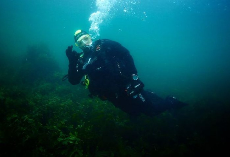
As part of the Northern Ireland Science Festival this year, the Centre for Environmental Data and Recording (CEDaR) is offering two Virtual Dives which will take you on an underwater journey above the seabed in Strangford Lough.

The dates are Thursday 18th and Thursday 25th February at 7 pm. Both are free online virtual experiences and are accessible for viewers with hearing loss.

Strangford Lough in County Down is almost landlocked and is the largest sea lough in the British Isles covering 150 sq km. Through the 8km long Narrows opening onto the Irish Sea at the southeastern end, 350 million litres of water flow twice a day.

The Lough supports diverse and colourful marine species communities for which it is designated as a Marine Conservation Zone, perfect for exploring. Queen's University Marine Biology Centre is located in Portaferry on Strangford Narrows.

To find out more click here

Published in Diving
Tagged under

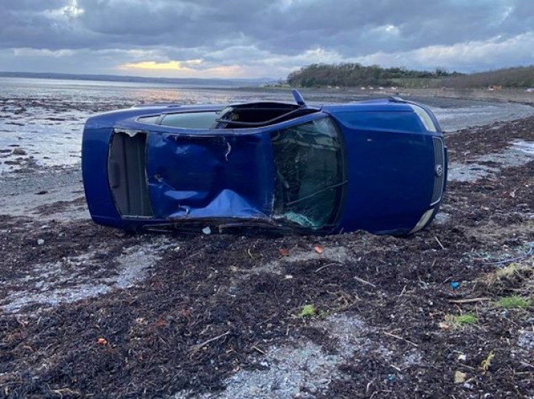
Belfast Coastguard Rescue Team responded yesterday (8th February) to reports of a car which had left the road near Newtownards Sailing Club, just a few miles outside the town on the loughshore road to Portaferry There were three people inside.

A coastal rescue officer from Portaferry was one of the first on the scene and had started casualty care before the arrival of a Rapid Response Vehicle (RRV) Paramedic. No serious injuries were reported.

PSNI and Coastguard personnel from Bangor helped with traffic management as well as checking that the vehicle was not leaking any fluids that could pollute the area. The team was free to stand down as recovery was arranged for the vehicle by the Police Service.

As reported in afloat.ie on 14th January, another vehicle left the same road a few miles farther south.

2nd February 2021

Tom Watson 1944-2021

Tommy Watson was a popular senior member of the Down Cruising Club, known to many sailors in its hospitable home on the Lightship Petrel, which is permanently moored alongside – complete with pontoons – in the hidden anchorage of Ballydorn near Whiterock on Strangford Lough.

He joined the club shortly after the ship – which had been saved by DCC from the breaker's yard - arrived from Irish Lights in Dublin in 1968. Tom readily and willingly became involved in DCC's can-do co-operative approach, with which it successfully faced the challenges of fully developing its characterful facilities. Always ready to undertake voluntary work, he progressed through the ranks to serve as Commodore, and was subsequently elected as President.

Down Cruising Club's ex-Lightship HQ has been in place at Ballydorn on Strangford Lough since 1968Down Cruising Club's ex-Lightship HQ has been in place at Ballydorn on Strangford Lough since 1968

He was to own many boats, which he personally maintained to a high standard. His first was an unfinished Aquamarine 4/21 which he completed at home, and after a few years, he progressed to a Sabre 27. He then joined Russell Murphy, another senior DCC member, in co-owning the Nicholson 36 "Daiquiri", a 1963 classic. The club ran a series of cruiser-races, and despite no prior experience, Tommy and Russell became increasingly keen and were anxious to perform better.

Thus they asked the well-known local skipper Dick Gomes to join them as helmsman and tactician, and such was their success that the club imposed a 10% "jockey penalty" on their handicap, which irked them somewhat even if the rest of the club thought it was a compliment to their developing skills and "Gomesie's" special genius. Their links with him didn't stop there, as they often cruised "Daiquiri" on the West Coast of Scotland in company with Dick and Deirdre Gomes in their classic yawl "Ain Mara".

“In 25 years partnership with Russell, after 10 good years with Daiquiri they bought a Moody 39, and then an even more gentlemanly Moody Eclipse 39. He loved the excitement of looking at boats, and then getting involved with them, with his final two being an LM 32 Deck Saloon, and then a Rival 32. Being one of DCC's most senior members with more than fifty club years eventually under his belt, he was a "Dornocrat", with his moorings right in the Dorn itself, rather than in one of the outer anchorages which were to be brought into use as the club's fleet expanded.

During his long sailing career, he also joined other crews on the Mediterranean and Caribbean and, rather less glamorously, crossing the North Sea from Norway. Often known as "Watty" he was a great shipmate and always popular aboard, and dependable with it.

Nicholson 36 DaquiriFor ten years, Tom Watson was co-owner of the classic Nich 36 Daiquiri

Tommy was passionate about Down Cruising Club, taking an active part in every area of the club, and about Strangford Lough generally. He was a member of Ringhaddy Cruising Club, and of Portaferry Sailing Club, and an enthusiastic supporter of the local RNLI Lifeboat station. This encouraged him to buy a holiday apartment in Portaferry. It was while staying there that he collapsed and died when out walking with his wife Laraine on the Shore Road on 21st January 2021.

Many expressions of sympathy have already been sent to Laraine and their daughter Suzanne. His excellent and helpful company will be greatly missed by the Down Cruising Club members, particularly at the traditional Sunday evening gatherings in the idiosyncratic bar on the Lightship after the pandemic has been moved on, at those quietly special occasions when Tommy Watson's company was much appreciated in times past.

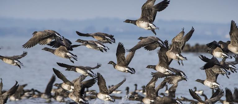
Strangford Lough is world-famous as the main arrival site for most of the migrating Canadian population (up to 80%) of pale-bellied Brent geese. Every autumn thousands of these birds leave their breeding grounds in eastern Canada and travel to Ireland to spend the winter. They leave Canada in late summer, travelling across Greenland, stopping off briefly in Iceland for a quick refuel before arriving in Ireland where they overwinter. Like their ancestors before them, most will arrive on the mudflats of Strangford to refuel on the nutritious eelgrass that grows in the intertidal sand and mudflats, although they will graze in the fields neighbouring the shore.

To protect these overwintering birds who arrive with their young, tired and hungry and in need of rest and food, the Strangford and Lecale Partnership has erected 'Share the Shore' panels in several sites around the Lough and at Killough Bay, (about 8km south-west of Downpatrick, on the County Down coast).

Strangford and Lecale Partnership has erected 'Share the Shore' panels in several sites around the Lough and at Killough Bay 'Share the Shore' panels are located in several sites around the Lough and at Killough Bay

The Share the Shore project out of a study in 2015/16 where the effects of dog walking on the bird population in Strangford Lough was monitored on a particular site – Greyabbey Bay on the east shore. From this study, it was concluded that a disturbance event affecting over-wintering birds occurs approximately once every hour. The data showed that most of this disruption is caused by dogs being walked off the lead and that excluding unknown and natural causes, off lead dogs cause the most severe response from the birds.

The birds have a small window to feed on the shore - as the tide goes out. Every time they are forced to take flight, they expend a great deal of energy and lose valuable feeding time. The panels give advice on dog walking to allow the birds to feed undisturbed.

The panels give advice on dog walking to allow the birds to feed undisturbedThe panels give advice on dog walking to allow the birds to feed undisturbed

The six panels are located in Kircubbin, Cunningburn and the Floodgates on the east side; at Island Hill and Whiterock on the western shore and at Killough on the coast.
The message is " Please take the time to consider the advice on these panels and always keep your dog on a lead!".

The Strangford and Lecale Partnership's aim is to conserve the magnificent natural and built heritage for future generations. They work with, and for, local people to achieve prosperity and social well-being, particularly through heritage, tourism, and sustainable outdoor recreation.

Published in Marine Wildlife

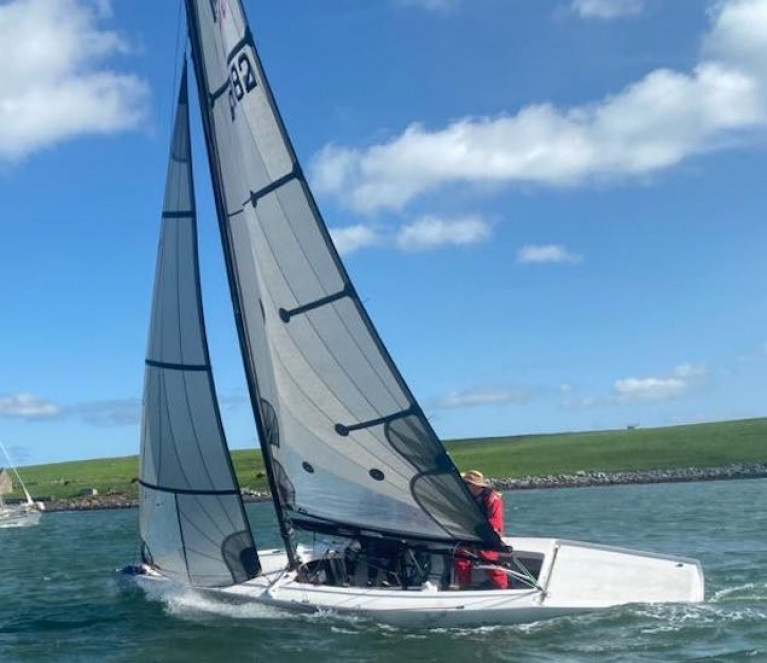
Last Sunday was the first day's racing for most of the RS Elites this year as a result of a Covid-19 hit 2020 season. Five boats made it onto Strangford Lough with the hope of another couple joining next weekend. 

Sailors were treated to a lively 20-knot easterly and sunshine. The first race started from the SLYC battery saw 4 boats in close contention upwind, there was a small misunderstanding about which was the correct windward mark which left a few boats reaching down to the laylines - Storm from RUYC led from Usain boat helmed by Richard Moore from RNIYC. Usain Boat had technical issues at the bear away stage and was overtaken by Illegal (SLYC)and Speedwell (RNIYC). Speedwell overtook Illegal on the 2nd beat whilst Storm maintained their lead.

Race 1

  1. Storm Stephen Polly
  2. Speedwell Ed Cody
  3. Illegal Phil Anderson

Royal Ulster and Royal North of Ireland Elites getting ready for their first outing of the year at Strangford LoughRoyal Ulster and Royal North of Ireland Elites getting ready for their first outing of the year at Strangford Lough

The second race was run in a calmer 10-15 knot shifty Easterly. Again, Storm pushed out in front, leading from Speedwell, and Merlin (SLYC). A 45-degree left-hand wind shift lead to this being more of a drag-race with few overtaking opportunities. All crew enjoyed the sunshine and being out on the water again

Race 2

  1. Storm Stephen Polly
  2. Speedwell Ed Cody
  3. Merlin  Angus McRoberts

Results here

Published in RS Sailing
Tagged under

The All Ireland Coast Watch survey for 2020 starts on Tuesday 15th September and Judith Caldwell of the Strangford Lough and Lecale Partnership is confident that there will be uptake around Strangford Lough and is keen to promote and encourage local people to take part. The project runs until 15th of October.

The SLLP is a conservation body which looks after the magnificent natural and built heritage of the Lough and Lecale, the latter an area of historic and geographic significance, bounded by the Quoile River, the Blackstaff River, the Irish Sea and Strangford Lough. SLLP operates within the Area of Outstanding Natural Beauty (AONB), bringing together stakeholders and local interest with representatives appointed by the Department of Agriculture, Environment and Rural Affairs.

The Coastwatch Survey is designed to give an overview of the state of the coast. It involves volunteers from all walks of life checking their chosen 500m stretch of coast (survey unit) once around low tide, and jotting observations down on the survey questionnaire while on the shore. This citizen science work can be augmented with water tests. Data is then collected and pooled to provide a snapshot of state in areas surveyed at that time.

More information can be found here

Published in Coastal Notes

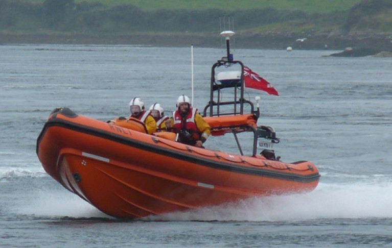
Portaferry RNLI rescued a kayaker who got into difficulty on Strangford Lough on Wednesday night (5 August).

The volunteer crew were on the scene with the inshore lifeboat just eight minutes after launch, following an alert from passers-by who heard the kayaker calling for help at Walter Rock in the Strangford Narrows.

Directed by those members of the public, the lifeboat reached the casualty who had been in the water for between 15 and 30 minutes, clinging to his upturned kayak.

He was taken onboard the lifeboat and made comfortable before being returned to shore and passed into the care of Portaferry Coastguard. The lifeboat crew then returned to the Narrows to recover the kayak.

Speaking after the callout, Portaferry RNLI press officer Jordan Conway said: “We would like to commend the members of the public who raised the alarm last night which ensured we reached the casualty in good time.

“As the summer season continues, we remind everyone planning a trip to sea to always respect the water.

“Always carry a means of calling for help and keep it within reach. Wear a personal flotation device and check the weather and tides.

“Tell someone where you are going and when you are due back and always wear appropriate clothing for the conditions and your trip.”

Published in RNLI Lifeboats
Page 4 of 11

General Information on using Waterways Ireland inland navigations

Safety on the Water

All users of the navigations are strongly recommended to make themselves aware of safety on the water for whatever activity they are involved in and to read the advice offered by the various governing bodies and by:

The Dept. of Transport, Ireland: www.gov.ie/transport and The Maritime and Coastguard Agency, UK, The RNLI – Water Safety Ireland for information in terms of drowning prevention and water safety.

Registration of Vessels

All vessels using the Shannon Navigation, which includes the Shannon-Erne Waterways and the Erne System must be registered with Waterways Ireland. Only open undecked boats with an engine of 15 horsepower or less on the Shannon Navigation, and vessels of 10 horsepower or less on the Erne System, are exempt. Registration is free of charge.

Craft registration should be completed online at: https://www.waterwaysireland.org/online-services/craft-registration

Permits for use of the Grand and Royal Canals and the Barrow Navigation

All vessels using the Grand and Royal Canals and the Barrow Navigation must display appropriate valid Permit(s) i.e A Combined Mooring and Passage Permit (€126) and if not intending to move every five days, an Extended Mooring Permit (€152).

Permit applications should be completed online at: https://www.waterwaysireland.org/online-services/canal-permits

Passage on the Royal and Grand Canals – Dublin Area

For boat passage through the locks east of Lock 12 into / out of Dublin on either the Royal or Grand Canals, Masters are requested to contact the Waterways Ireland Eastern Regional Office (M-F 9.30am-4.30pm) on tel: +353(0)1 868 0148 or email [email protected] prior to making passage in order to plan the necessary lock-keeping assistance arrangements.

On the Grand Canal a minimum of two days notice prior to the planned passage should be given, masters should note that with the exception of pre-arranged events, a maximum of 2 boats per day will be taken through the locks, travelling either east or west.

Movements in or out of the city will be organised by prior arrangement to take place as a single movement in one day. Boaters will be facilitated to travel the system if their passage is considered to be safe by Waterways Ireland and they have the valid permit(s) for mooring and passage.

Newcomen Lifting Bridge

On the Royal Canal two weeks’ notice of bridge passage (Newcomen Lifting Bridge) is required for the pre-set lift date, and lock assistance will then also be arranged. A minimum of 2 boats is required for a bridge lift to go ahead.

Waterways Ireland Eastern Regional Office (Tel: +353(0)1 868 0148 or [email protected] ) is the point of contact for the bridge lift.

A maximum number of boats passing will be implemented to keep to the times given above for the planned lifts (16 for the Sat / Sun lifts & 8 for the weekday lifts). Priority will be given on a first come first served basis.

On day of lift, boaters and passengers must follow guidance from Waterways Ireland staff about sequence of passage under bridge & through Lock 1, and must remain within signed and designated areas.

Events Held on the Waterways

All organised events taking place on the waterways must have the prior approval of Waterways Ireland. This is a twelve week process and application forms must be accompanied with the appropriate insurance, signed indemnity and risk assessment. The application should be completed on the Waterways Ireland events page at :

https://www.waterwaysireland.org/online-services/event-approval

Time Limits on Mooring in Public Harbours

On the Shannon Navigation and the Shannon-Erne Waterway craft may berth in public harbours for five consecutive days or a total of seven days in any one month.

On the Erne System, revised Bye Laws state that: No master or owner shall permit a vessel, boat or any floating or sunken object to remain moored at or in the vicinity of any public mooring, including mooring at any other public mooring within 3 kilometres of that location, for more than 3 consecutive days and shall not moor at that same mooring or any other public mooring within 3 kilometres of that location within the following 3 consecutive days without prior permission by an authorised official.

Winter Mooring on the Shannon Navigation and Shannon Erne Waterway

Winter mooring may be availed of by owners during the period 1 Nov to 31 Mar by prior arrangement and payment of a charge of €63.50 per craft. Craft not availing of Winter Mooring must continue to comply with the “5 Day Rule”. Winter Mooring applications should be completed online at : https://www.waterwaysireland.org/online-services/winter-moorings-booking

Owners should be aware that electricity supply and water supply to public moorings is disconnected for the winter months. This is to protect against frost damage, to reduce running costs and to minimise maintenance requirements during the winter months.

Vessel owners are advised that advance purchasing of electricity on the power bollards leading up to the disconnection date should be minimal. Electricity credit existing on the bollards will not be recoverable after the winter decommissioning date. Both services will be reinstated prior to the commencement of the next boating season.

Smart Cards

Waterways Ireland smart cards are used to operate locks on the Shannon Erne Waterway, to access the service blocks, to use the pump-outs along the navigations, to avail of electrical power at Waterways Ireland jetties.

Berthing in Public Harbours

Masters are reminded of the following:

  • Equip their vessel with mooring lines of appropriate length and strength and only secure their craft to mooring bollards and cleats provided for this purpose.
  • Ensure the available berth is suitable to the length of your vessel, do not overhang the mooring especially on finger moorings on floating pontoon moorings.
  • Ensure mooring lines, electric cables and fresh water hoses do not create a trip hazard on public jetties for others users.
  • Carry sufficient fenders to prevent damage to your own vessel, other vessels and WI property.
  • Allow sufficient space between your vessel and the vessel ahead /astern (c.1m) for fire safety purposes and /or to recover somebody from the water.
  • Do not berth more than two vessels side by side and ensure there is safe access/egress at all times between vessels and onto the harbour itself.
  • Do not berth in such a way to prevent use of harbour safety ladders, slipways or pump-outs.
  • Do not allow the bow of your vessel to overhang the walkway of a floating mooring thus creating a hazard for others with an overhanging anchor or bow fendering.
  • Animals are not allowed to be loose or stray at any time.
  • Harbour and jetty infrastructure such as railings, power pedestals, fresh water taps, electric light poles, safety bollards, ladders etc are not designed for the purpose of mooring craft , they will not bear the strain of a vessel and will be damaged.
  • At Carrybridge on the Erne System, Masters of vessels are not permitted to use stern on mooring. Masters of vessels must use the mooring fingers for mooring of vessels and for embarkation / disembarkation from vessels.

Passenger Vessel Berths

Masters of vessels should not berth on passenger vessel berths where it is indicated that an arrival is imminent. Passenger vessels plying the navigations generally only occupy the berths to embark and disembark passengers and rarely remain on the berths for extended periods or overnight.

Lock Lead-in Jetties

Lead-in jetties adjacent to the upstream and downstream gates at lock chambers are solely for the purpose of craft waiting to use the lock and should not be used for long term berthing.

Vessel Wake

Vessel wake, that is, the wave generated by the passage of the boat through the water, can sometimes be large, powerful and destructive depending on the hull shape and engine power of the vessel. This wake can be detrimental to other users of the navigation when it strikes their craft or inundates the shoreline or riverbank. Masters are requested to frequently look behind and check the effect of their wake / wash particularly when passing moored vessels, on entering harbours and approaching jetties and to be aware of people pursuing other activities such as fishing on the riverbank.

Speed Restriction

A vessel or boat shall not be navigated on the Shannon Navigation at a speed in excess of 5 kph when within 200 metres of a bridge, quay, jetty or wharf, when in a harbour or canal or when passing within 100 metres of a moored vessel or boat.

Vessels navigating the Shannon-Erne Waterway should observe the general 5 kph speed limit which applies along the waterway. This is necessary in order to prevent damage to the banks caused by excessive wash from vessels.

Vessels navigating the Erne System should observe the statutory 5kt / 6mph / 10kph speed limit areas.

A craft on the Royal and Grand canals shall not be navigated at a speed in excess of 6km per hour.

A craft on the Barrow Navigation shall not be navigated at a speed in excess of 11km per hour except as necessary for safe navigation in conditions of fast flow.

Bank Erosion

Narrow sections of all the navigations are particularly prone to bank erosion due to the large wash generated by some craft. Masters are requested to be vigilant and to slow down to a speed sufficient to maintain steerage when they observe the wash of their craft inundating the river banks.

Unusual Waterborne Activity

Unusual waterborne vessels may be encountered from time to time, such as, hovercraft or amphibious aircraft / seaplanes. Masters of such craft are reminded to apply the normal “Rule of the Road” when they meet conventional craft on the water and to allow extra room to manoeuvre in the interest of safety.

Sailing Activity

Mariners will encounter large numbers of sailing dinghies from late June to August in the vicinity of Lough Derg, Lough Ree and Lower Lough Erne. Sailing courses are marked by yellow buoys to suit weather conditions on the day. Vessels should proceed at slow speed and with due caution and observe the rules of navigation when passing these fleets, as many of the participants are junior sailors under training.

Rowing

Mariners should expect to meet canoes and vessels under oars on any part of the navigations, but more so in the vicinity of Athlone, Carrick-on-Shannon, Coleraine, Enniskillen and Limerick. Masters are reminded to proceed at slow speed and especially to reduce their wash to a minimum when passing these craft as they can be easily upset and swamped due to their very low freeboard and always be prepared to give way in any given traffic situation.

Canoeing

Canoeing is an adventure sport and participants are strongly recommended to seek the advice of the sport’s governing bodies i.e Canoeing Ireland and the Canoe Association of Northern Ireland, before venturing onto the navigations.

Persons in charge of canoes are reminded of the inherent danger to these craft associated with operating close to weirs, sluice gates, locks and other infrastructure particularly when rivers are in flood and large volumes of water are moving through the navigations due to general flood conditions or very heavy localised precipitation e.g. turbulent and broken water, stopper waves. Shooting weirs is prohibited without prior permission of Waterways Ireland.

Canoeists should check with lockkeepers prior entering a lock to ensure passage is done in a safe manner. Portage is required at all unmanned locks.

Canoe Trail Network – "Blueways"

Masters of powered craft are reminded that a canoe trail network is being developed across all navigations and to expect more organised canoeing along these trails necessitating slow speed and minimum wash when encountering canoeists, rowing boats etc

Rockingham and Drummans Island Canals – Lough Key

It is expected that work on Rockingham and Drummans Island Canals on Lough Key will be completed in 2021. Access to these canals will be for non-powered craft only, eg canoes, kayaks, rowing boats.

Fast Powerboats and Personal Watercraft (Jet Skis)

Masters of Fast Powerboats (speed greater than 17kts) and Personal Watercraft (i.e.Jet Skis) are reminded of the inherent dangers associated with high speed on the water and especially in the confines of small bays and narrow sections of the navigations. Keeping a proper look-out, making early alterations to course and /or reducing speed will avoid conflict with slower vessels using the navigation. Personal Watercraft are not permitted to be used on the canals.

Towing Waterskiers, Wakeboarders, Doughnuts etc

Masters of vessels engaged in any of these activities are reminded of the manoeuvring constraints imposed upon their vessel by the tow and of the added responsibilities that they have to the person(s) being towed. These activities should be conducted in areas which are clear of conflicting traffic. It is highly recommended that a person additional to the master be carried to act as a “look-out” to keep the tow under observation at all times.

Prohibition on Swimming

Swimming in the navigable channel, particularly at bridges, is dangerous and is prohibited due to the risk of being run over by a vessel underway in the navigation.

Age Restrictions on operating of powered craft

In the Republic of Ireland, Statutory Instrument 921 of 2005 provides the legal requirements regarding the minimum age for operating of powered craft. The Statutory Instrument contains the following requirements:

- The master or owner of a personal watercraft or a fast power craft shall take all reasonable steps to ensure that a person who has not attained the age of 16 years does not operate or control the craft

- The master or owner of a pleasure craft powered by an engine with a rating of more than 5 horse power or 3.7 kilowatts shall take all reasonable steps to ensure that a person who has not attained the age of 12 years does not operate or control the craft.

Lifejackets and Personal Flotation Devices (PFDs)

Lifejackets and PFD’s are the single most important items of personal protective equipment to be used on a vessel and should be worn especially when the vessel is being manoeuvred such as entering / departing a lock, anchoring, coming alongside or departing a jetty or quayside.

In the Republic of Ireland, Statutory Instrument 921 of 2005 provides the legal requirements regarding the wearing of Personal Flotation Devices. The Statutory Instrument contains the following requirements:

- The master or owner of a pleasure craft (other than a personal watercraft) shall ensure, that there are, at all times on board the craft, sufficient suitable personal flotation devices for each person on board.

- A person on a pleasure craft (other than a personal watercraft) of less than 7 metres length overall shall wear a suitable personal flotation device while on board an open craft or while on the deck of decked craft, other than when the craft is made fast to the shore or at anchor.

- The master or owner of a pleasure craft (other than a personal watercraft) shall take all reasonable steps to ensure that a person who has not attained the age of 16 years complies with paragraph above.

- The master or owner of a pleasure craft (other than a personal watercraft), shall take all reasonable steps to ensure that a person who has not attained the age of 16 years wears a suitable personal flotation device while on board an open craft or while on the deck of a decked craft other than when it is made fast to the shore or at anchor.

- The master or owner of a pleasure craft (other than a personal watercraft) shall take all reasonable steps to ensure that a person wears a suitable personal flotation device, at all times while – (a) being towed by the craft, (b) on board a vessel or object of any kind which is being towed by the craft.

Further information is available at: http://www.irishstatutebook.ie/eli/2005/si/921/made/en/print

Firing Range Danger Area – Lough Ree

The attention of mariners is drawn to the Irish Defence Forces Firing Range situated in the vicinity of buoys No’s 2 and 3, on Lough Ree on the Shannon Navigation. This range is used regularly for live firing exercises, throughout the year, all boats and vessels should stay clear of the area marked with yellow buoys showing a yellow "X" topmark and displaying the word "Danger".

Shannon Navigation, Portumna Swing Bridge Tolls

No attempt should be made by Masters’ of vessels to pay the bridge toll while making way through the bridge opening. Payment will only be taken by the Collector from Masters when they are secured alongside the jetties north and south of the bridge.

Navigating from Killaloe to Limerick on the Shannon Navigation

The navigation from Killaloe to Limerick involves passage through Ardnacrusha locks, the associated headrace and tailrace and the Abbey River into Limerick City. Careful passage planning is required to undertake this voyage. Considerations include: lock passage at Ardnacrusha, water flow in the navigation, airdraft under bridges on Abbey River in Limerick, state of tide in Limerick

Users are advised to contact the ESB Ardnacrusha hydroelectric power station (00353 (0)87 9970131) 48 hours in advance of commencing their journey to book passage through the locks at Ardnacrusha. It is NOT advised to undertake a voyage if more than one turbine is operating (20MW), due to the increased velocity of flow in the navigation channel, which can be dangerous. To ascertain automatically in real time how many turbines are running, users can phone +353 (0)87 6477229.

For safety reasons the ESB has advised that only powered craft with a capacity in excess of 5 knots are allowed to enter Ardnacrusha Headrace and Tailrace Canals.

Passage through Sarsfield Lock should be booked on +353-87-7972998, on the day prior to travel and it should be noted also that transit is not possible two hours either side of low water.

A Hydrographic survey in 2020 of the navigation channel revealed that the approach from Shannon Bridge to Sarsfield Lock and the Dock area has silted up. Masters of vessels and water users are advised to navigate to the Lock from Shannon bridge on a rising tide one or two hours before High Tide.

Lower Bann Navigation

The attention of all users is drawn to the “Users Code for the Lower Bann”, in particular to that section covering “Flow in the River” outlining the dangers for users both on the banks and in the navigation, associated with high flow rates when the river is in spate. Canoeists should consult and carry a copy of the “Lower Bann Canoe Trail” guide issued by the Canoe Association of Northern Ireland. Users should also contact the DfI Rivers Coleraine, who is responsible for regulating the flow rates on the river, for advisory information on the flow rates to be expected on any given day.

DfI Rivers Coleraine. Tel: 0044 28 7034 2357 Email: [email protected]

Lower Bann Navigation – Newferry – No wake zone

A No Wake Zone exists on the Lower Bann Navigation at Newferry. Masters of vessels are requested to proceed at a slow speed and create no wake while passing the jetties and slipways at Newferry.

Overhead Power Lines (OHPL) and Air draft

All Masters must be aware of the dangers associated with overhead power lines, in particular sailing vessels and workboats with cranes or large air drafts. Voyage planning is a necessity in order to identify the location of overhead lines crossing the navigation.

Overhead power line heights on the River Shannon are maintained at 12.6metres (40 feet) from Normal Summer level for that section of navigation, masters of vessels with a large air draft should proceed with caution and make additional allowances when water levels are high.

If a vessel or its equipment comes into contact with an OHPL the operator should NOT attempt to move the vessel or equipment. The conductor may still be alive or re-energise automatically. Maintain a safe distance and prevent third parties from approaching due to risk of arcing. Contact the emergency services for assistance.

Anglers are also reminded that a minimum ground distance of 30 metres should be maintained from overhead power lines when using a rod and line.

Submarine Cables and Pipes

Masters of vessels are reminded not to anchor their vessels in the vicinity of submarine cables or pipes in case they foul their anchor or damage the cables or pipes. Look to the river banks for signage indicating their presence.

Water Levels - Precautions

Low Water Levels:

When water levels fall below normal summer levels masters should be aware of:

Navigation

To reduce the risk of grounding masters should navigate on or near the centreline of the channel, avoid short cutting in dog-legged channels and navigating too close to navigation markers.

Proceeding at a slow speed will also reduce “squat” effect i.e. where the vessel tends to sit lower in the water as a consequence of higher speed.

Slipways

Reduced slipway length available under the water surface and the possibility of launching trailers dropping off the end of the concrete apron.

More slipway surface susceptible to weed growth requiring care while engaged in launching boats, from slipping and sliding on the slope. Note also that launching vehicles may not be able to get sufficient traction on the slipway once the craft is launched to get up the incline.

Bank Erosion

Very dry riverbanks are more susceptible to erosion from vessel wash.

Lock Share

Maximising on the number of vessels in a lock will ensure that the total volume of water moving downstream is decreased. Lock cycles should be used for vessels travelling each way.

High Water Levels:

When water levels rise above normal summer level masters should be aware of:

Navigation

Navigation marks will have reduced height above the water level or may disappear underwater altogether making the navigable channel difficult to discern.

In narrow sections of the navigations water levels will tend to rise more quickly than in main streams and air draft at bridges will likewise be reduced.

There will also be increased flow rates particularly in the vicinity of navigation infrastructure such as bridges, weirs, locks etc where extra care in manoeuvring vessels will be required.

Harbours and Jetties

Due care is required in harbours and at slipways when levels are at or near the same level as the harbour walkways' as the edge will be difficult to discern especially in reduced light conditions. It is advised that Personal Flotation Devices be worn if tending to craft in a harbour in these conditions.

Slipways

Slipways should only be used for the purpose of launching and recovering of water craft or other objects from the water. Before using a slipway it should be examined to ensure that the surface has sufficient traction/grip for the intended purpose such as launching a craft from a trailer using a vehicle, that there is sufficient depth of water on the slipway to float the craft off the trailer before the concrete apron ends and that the wheels of the trailer do not drop off the edge of the slipway. That life-saving appliances are available in the vicinity, that the vehicle is roadworthy and capable of coping with the weight of the trailer and boat on the incline. It is recommended that slipway operations are conducted by two persons.

Caution to be Used in Reliance upon Aids to Navigation

The aids to navigation depicted on the navigation guides comprise a system of fixed and floating aids to navigation. Prudent mariners will not rely solely on any single aid to navigation, particularly a floating aid to navigation. With respect to buoys, the buoy symbol is used to indicate the approximate position of the buoy body and the ground tackle which secures it to the lake or river bed. The approximate position is used because of the practical limitations in positioning and maintaining buoys in precise geographical locations. These limitations include, but are not limited to, prevailing atmospheric and lake/river conditions, the slope of and the material making up the lake/river bed, the fact that the buoys are moored to varying lengths of chain, and the fact that the buoy body and/or ground tackle positions are not under continuous surveillance. Due to the forces of nature, the position of the buoy body can be expected to shift inside and outside the charted symbol.

Buoys and perches are also moved out of position or pulled over by those mariners who use them to moor up to instead of anchoring. To this end, mariners should always monitor their passage by relating buoy/perch positions with the published navigation guide. Furthermore, a vessel attempting to pass close by always risks collision with a yawing buoy or with the obstruction that the buoy or beacon/perch marks.

Masters of Vessels are requested to use the most up to date Navigation guides when navigating on the Inland Waterways.

Information taken from Special Marine Notice No 1 of 2023