


Displaying items by tag: Barrow
Carlow Tourism Industry Members Support Barrow Towpath Plans
#InlandWaters - Carlow Tourism board members were strong in their praise and support for the Barrow Towpath Development Project at their most recent meeting.
Industry members noted that the project, spearheaded by Waterways Ireland, is a “once-in-a-lifetime opportunity” to develop a high quality multi-activity leisure trail, with the ability to give the River Barrow and Barrow Way route an elevated status among Ireland’s inland waterways.
Mark O'Brien, board director and owner of the Old Grain Store Cottages and the Mullicháin Café in St Mullins, said: “For many years and in many reports the River Barrow and the unique features of the towpath which runs alongside it, has been identified as a key tourism asset, but also as a completely under-utilised resource in this regard.
“The key to unlocking the tourism potential of Co Carlow is in no small way rooted in the further development of the River Barrow and Barrow Way route. As has happened along the Great Western Greenway, this project will be the important influencing factor for visitors in their decision to travel to Co Carlow.”
Eileen O'Rourke, chief executive of Carlow Tourism, added that the project “will inject much needed jobs and revenue into Carlow's rural communities, sustaining them to keep local people in their local area.
“Research undertaken by Fáilte Ireland and Mayo County Council in respect of the Great Western Greenway in Mayo, whose length is much shorter than the Barrow Towpath, highlights its noticeable impact on business to the area, contributing €7.2 million annually to the local economy, creating 38 new full-time jobs and sustaining another 56 jobs.”
Board members also noted that “misinformation” is being circulated about the project, such as suggestions that the route would comprise a three-metre-wide tarmac path fenced in from the waterway.
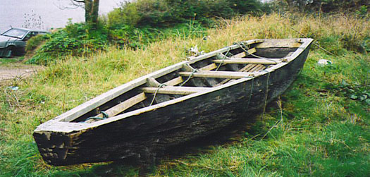
The proposed development will use clean stone and compacted quarry dust to a maximum width of 2.5 metres, similar to that already in use along some stretches of the towpath in Graiguenamanagh, Goresbridge, Leighlinbridge and Bestfield, and in keeping with the standards laid down by the National Trails Office and Transport Infrastructure Ireland (TII) for walking and cycling usage – and will not be of interest to speed cyclists.
Only the existing access roadway downstream from St Mullins Lock, already prone to erosion, will be resurfaced with reinforced concrete, says Carlow Tourism, which promises that the “unspoilt nature of the towpath will be maintained, but with better facilities for the visitor to enjoy.”
Industry members on the board of Carlow Tourism reportedly view the project as responding to a strong market demand by domestic and overseas visitors alike.
James Kehoe — owner of the Lord Bagenal Hotel, whose property fronts onto the River Barrow — notes the increasing emphasis on activity based holidays.
"Currently Co Carlow is not benefiting from this trend, which would be facilitated by completion of the towpath development project. The planning upgrades proposed will increase the year round accessibility of the Barrow towpath to people of all ages and physical ability for a range of activities.
“[At present] visitors are unable to use the towpath at certain periods of the year due to its poor state. It is also very difficult to gauge with reasonably accuracy the state of the towpath in other areas following periods of poor weather.
“The proposed surface will allow us to attract visitors to walk the Barrow towpath, in greater numbers, which will also give greater security to those walking the towpath as single users. I am in no doubt that a range of facilities will accompany the development of this project, which will foster new jobs for the local area."
The proposal has received a warm welcome from Arthur Keppel, president of the Inland Waterways Association of Ireland’s Barrow branch and chair of the Barrow Awards judging panel.
"The Barrow Awards are designed to reward towns and villages along the River Barrow for maintaining and enhancing the wonderful natural resources of the river,” he said. “Year on year we see excellent projects implemented by groups, in an entirely voluntary capacity who are keen to ensure an enjoyable experience for users of the towpath in their respective areas.”
Industry members of the board were strong in their praise for Waterways Ireland and their level of engagement and consultation with the public.
They also noted that the proposal forms part of a larger strategy for the River Barrow, completed by Waterways Ireland in consultation with a number of key partners, with the goal of ensuring higher visibility and recognition for Ireland's second longest river as a special area with strong heritage values.
The strategy recognises the potential of the river to become a busier waterway, as in years gone by when the river was a commercial hub, with benefits for both locals and visitors.
Waterways Ireland To Submit Planning Applications on Barrow Way Upgrades
Waterways Ireland will submit planning applications to Kildare, Laois and Carlow County Councils in December 2016 for upgrades to the Barrow Way-marked Way.
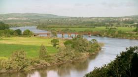
The planning submission is an application for the upgrading of the existing navigation towpath which is also a National Way-marked Way along the Grand Canal – Barrow Line and the River Barrow. It will provide a multi-use shared leisure route connecting Lowtown in County Kildare to St. Mullins in County Carlow. The trail will follow through the towns of Rathangan, Monasterevin, Vicarstown, Athy, Carlow, Leighlinbridge, Bagenalstown, Goresbridge, Graiguenamanagh and St. Mullins. Once the work is complete on the 115km route, Waterways Ireland will work with the local business and tourism providers to develop the route into a Blueway, a 'slow' tourism product, focusing on leisure activities.
The proposal to develop the Barrow towpath originates from the 2011 Barrow Corridor Recreational, Tourism and Commercial Product Identification Study where Fáilte Ireland, Waterways Ireland, Carlow County Development Partnership, Kilkenny LEADER Partnership and the four local authorities worked together to examine strategic leisure and recreational opportunities for the Barrow Valley. The group, the Barrow Steering Group, commissioned research and proposals were published for sustainable recreational and tourism development programmes which balance the need for economic development with the protection of the environment. As the Authority charged with managing the Grand Canal & Barrow Navigation, Waterways Ireland took the lead on the design phase for the proposed route. Extensive public consultation on the project took place in 2014 and Waterways Ireland proceeded to undertake a comprehensive and robust design and environmental assessment of the route to ensure the proposal was sympathetic to the receiving environment.
The planning applications may be inspected, or purchased at a fee not exceeding the reasonable cost of making a copy, at the offices of the three planning authorities during their public opening hours. In addition, the file may be accessed online through the planning authority's e-planning portals. A submission or observation in relation to the application may be made in writing to the planning authority on payment of the prescribed fee (€20) within the period of 5 weeks beginning on the date of receipt by the authority of the application. Due to the Christmas Holidays an extra 9 days have been added to the process to ensure that as many people as possible have an opportunity to make a submission.
Advertisements have been placed in both national and regional newspapers to maximise awareness of the applications in compliance with planning requirements. Waterways Ireland are also advertising the planning application on our website / social media and have contacted those who registered following the 2014 public consultation to ensure members of the public have every opportunity to engage with the planning process.
Beyond the planning requirements Waterways Ireland is also hosting a series of Public Information Sessions where engineering and environmental staff will be in attendance to share the plans for each area so that everyone has the opportunity to be fully aware of what is planned before submitting their comments to the planning authorities. These events are taking place as follows:
|
County |
Date |
Time |
Venue |
|
Carlow |
16th January 2017 |
3pm - 7pm |
Seven Oaks Hotel, Carlow |
|
Kilkenny |
17th January 2017 |
3pm - 7pm |
Scout Hall, Graiguenamanagh |
|
Kildare |
18th January 2017 |
3pm - 7pm |
Athy Community Library, Athy |
|
Laois |
19th January 2017 |
3pm - 7pm |
Vicarstown Inn, Vicarstown
|

#barrowblueway – Waterways Ireland in partnership with Carlow, Kilkenny, Kildare and Laois County Councils and LEADER Companies is proposing to develop a Barrow Blueway, a 112km long shared-use trail for local people and visitors to enjoy along the route of the Barrow Way-Marked Way.
Following on from a number of studies and reports commissioned by various authorities including Waterways Ireland, the Local Authorities, LEADER Partnership Companies and Fáilte Ireland a series of interventions and programmes have been agreed and are being implemented by the agencies both collectively and individually. One such initiative is the Barrow Blueway.
The Barrow River and Barrow Line of the Grand Canal are waterway corridors of National and International importance and spectacular recreation and leisure amenities. Both the river and canal support a myriad of sustainable activities and sustain a rich and diverse built and natural heritage. It is the intention of Waterways Ireland to develop the existing trackway along the Barrow Line of the Grand Canal and Barrow River as a 112km Blueway. The Blueway would support a myriad of recreation activities, help grow and develop business along the length of the Barrow Blueway. The proposal entails the upgrading of the existing trackway to allow a multi use shared leisure route connecting Lowtown in Co. Kildare to St. Mullins in Co. Carlow, travelling through Lowtown, Rathangan, Monasterevin, Athy, Carlow, Leighlinbridge, Bagenalstown, Goresbridge, Graiguenamanagh and St Mullins.
Éanna Rowe, Head of Marketing & Communications, Waterways Ireland confirmed "Waterways Ireland is delighted to have progressed the Barrow Blueway proposal to the point where we now have meaningful information to share. We look forward to the Public Information Evenings where local businesses, activity providers, clubs, associations and all interested parties can come and view the proposals, examine design options and engage with our staff. We welcome all feedback and indeed will consider it as plans are finalised for this exciting new recreation and tourism initiative. "
The project is currently at design stage with tailored surface finishes to be employed to ensure a durable and fit for purpose trail in accordance with National Trails Office Guidance. This surfacing will not only improve accessibility but provide a more robust surface that will be able to better withstand footfall and traffic. Whilst it is proposed to employ a compacted stone and dust surface, a reinforced grass solution may be used in sensitive locations as guided by environmental requirements to preserve the grassy surface so valued by many people.
Carlow County Council Spokesman stated " In the context of progressing the economic and social development of the county, Carlow County Council is open to exploring and considering all recreational and tourism products, which may have a positive impact for the county, region and country, being mindful of the importance of its obligation to protect and enhance the environment and quality of life for all who live in, work in or visit the county".
Environmental studies have been commissioned including an Appropriate Assessment, given the route is partly within an SAC, and an Environmental Impact Assessment. These reports will be informed by detailed ecological assessments commissioned by Waterways Ireland ensuring the design of the Blueway is led by the baseline ecology present along the corridor.
Kilkenny Director of Services John Mc Cormack stated "Kilkenny County Council is supportive of this initiative which will maximise the tourism and recreational potential of the River Barrow for the benefit of the local economies of Graiguenamanagh, Goresbridge and the South East region in general."
The Blueway brand which Waterways Ireland has developed in conjunction with the National Trails Office, Fáilte Ireland and Canoeing Ireland, will also be used to promote internationally, the special journeys which take place either on foot, bicycle or boat on shared use trails along Ireland's Inland Waterways. Walking, cycling and canoeing activities have been shown to be highly sustainable as people engage in low group numbers, all year round and require services and facilities similar to those readily available in the towns and villages along the Barrow Valley. The Barrow Blueway is ideally suited to belong to this brand and well- placed to add to the economic and social sustainability of its towns and villages.
Before progressing the project further, Waterways Ireland would like to invite interested parties from local communities, activity providers, accommodation and food establishments to view the designs, proposed route and take the opportunity to meet and speak to Waterways Ireland personnel and give feedback on the project.
join at the following locations
Carlow: 20th November 2-7pm in the Seven Oaks Hotel, Carlow
Killkenny: 21st November 2-7pm in the Scout Hall, Graiguenamanagh
Laois: 27th November 2-7pm in the Vicarstown Inn, Vicarstown
Kildare: 4th December 2-7pm in the Community Library, Athy.
If unable to come to any of the meetings, view the information online here and submit your feedback online.
Waterways Ireland is happy to receive feedback up until the 5th January 2015. At that point all the feedback submitted will be reviewed, appropriate amendments made and an application for planning permission submitted.
#thisislandnation – After an absence of several years it is a pleasure to return to the airwaves, a decision I have taken in pursuance of my belief that the national media is seriously neglectful of maritime matters. The marine sphere is not adequately served by the national media, print or broadcast. The specialist media such as AFLOAT and community radio offers an alternative voice, so do social media outlets.
THIS ISLAND NATION is a monthly hour-long radio programme of which the first edition available here on Afloat.ie highlights the decay forced upon coastal communities by government and EU policies.
Sean Doherty, who I interviewed for my programme at the 'EMPOWERING COASTAL COMMUNITIES' Conference in County Waterford, is a man who is trying to preserve his local community at Cheekpoint on the Waterford Estuary. He describes how the ending of the drift net fishery, followed by the closure of the eel fishery, has contributed to what he sees as the destruction of his community. Men earned a living from the fisheries for their families, others were employed to maintain engines on the boats, more had work repairing the fishing boats and local restaurants served their catches as local produce. But these aspects of life in Cheekpoint no longer exist. The village has suffered heavily. His interview indicates how decisions were made by politicians and State administrators without carrying out any examination of the social effects and the damage they would cause to the communities affected. Those communities were treated with disregard and what amounts to contempt for their future. It is a sombre story.
The oceans are, in places, a wilderness, sweeping the globe and washing the edges of our cities. They provide opportunity and potential. The coastal communities are the first interface of Ireland with the sea at the coastal rim of this island nation.
So why is it that the sea is not regarded as a priority national interest?
The answer lies in a failure of political and economic perception, fuelled by an adherence to globalisation rather than pride in being an island nation.
Ireland is the most western island nation in Europe, but there is no pride evident in Government circles that we Irish are islanders. At the highest level of political life and civil service administration, as well as amongst the national media and the general public, there is a failure of perception to realise that being islanders gives Irish people an unique place in Europe. The concept of globalisation, which policies favour, is the destruction of uniqueness.
As Sean Doherty says in the interview, there are publicly expressed concerns and movements calling for the protection of indigenous communities around the world; and for the promotion of multi-culturalism in Ireland; but there is little or no interest and no movements for the preservation of the indigenous people of Ireland –the coastal and fishing communities.
The voice of the sea can speak to the soul, that voice should be heard by those who make the decisions which affect Ireland.
While there are some positive steps, which are also outlined in the programme - THIS ISLAND NATION - which you can hear on this website, these are not enough to counterbalance neglect of the maritime sphere. More is needed.
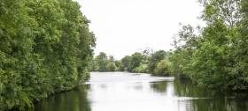
Cheekpoint nestles in the Waterford Estuary near where the Rivers Suir and Barrow meet, lying beneath Minaun Hill and has a magnificent, panoramic view across Waterford Harbour.
Sean Doherty described himself to me as an angry, frustrated man at what he sees as he looks out from his home on the estuary, "because what I am seeing is destruction caused by a form of blindness."
The Prong is the local boat which has been used by fishermen from the village. The first one built in many years is pictured below, together with an example of an older boat. The coastal communities are endeavouring to maintain their maritime heritage. So should the nation.
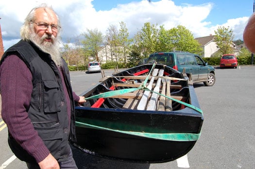
Above John Gossip with the new Cheekpoint Prong and below an older example of the craft
Twitter: @TomMacSweeney
Grand, Royal Canal & Barrow Navigation Mooring Rules Come into Force

#inland – Waterways Ireland announced in June 2012 that the Canal Bye-laws on the Grand & Royal Canal and Barrow Navigation are to be enforced from autumn 2012, with an accompanying change in the permit system allowing for year-long mooring permits and locations.
Part of bringing in this new location-based permit has been the identification of locations suitable for extended mooring. This process is now completed and work has begun in some areas to improve accessibility.
Waterways Ireland will roll out Extended Mooring Permit applications by area, rather than giving a date when applications for the permit will open. For boat owners this will mean that enforcement of the maximum stay rule will not commence in an area until after boat owners have had the opportunity to purchase an Extended Mooring Permit.
The initial 12 month Extended Mooring Permit will cost €152 and will only be available to boats already holding a valid annual Mooring and Passage Permit.
Boats that cruise and move (staying at a mooring for up to 5 days) will not be in breach of the Bye-laws or require an Extended Mooring Permit.
Waterways Ireland has proposed a small number of draft amendments to the current Bye-laws which date from 1988. These include proposals to provide a range of charges for mooring permits that reflect the location and services provided throughout the canals and also will take into account the size of boat. These proposals include low cost rural moorings on soft banks to ensure the canals are accessible for everyone who owns a boat and requires a mooring. Boat owners allocated an extended mooring location in key areas in villages or towns or with services should be aware that if the new Bye-laws are approved Waterways Ireland will increase the charges for moorings in the future to reflect the location, services, and size of boat.
Waterways Ireland recognises the current situation whereby a small number of boat owners use their boats as their sole or permanent residence. Proposals to make provision for this use of the navigation property have been included in the Bye-law changes.
Furthermore Waterways Ireland intends to work towards the provision of a small number of serviced house boat moorings on the canal network. Such provision will be subject to finance, land availability and compliance with requisite statutory approvals.
Waterways Ireland recognises that a transition period of a number of years will be required to implement this. In the interim these boat owners should apply for an Extended Mooring Permit.
The draft Bye Law amendments are currently being considered by Waterways Ireland's sponsor Departments. When Waterways Ireland has Ministerial consent, it will proceed to public consultation on the proposed Bye-law amendments.
Waterways Ireland will continue to contact permit holders regularly to ensure they are kept up to date with the roll-out of the new permit. All queries about the enforcement of the current bye-laws or the Extended Mooring Permit should be directed to Shane Anderson, Assistant Inspector of Navigation: Tel no +353 (0)87 286 5726, Email [email protected] . Queries about houseboats should be directed to Property & Legal Section Tel no +44 (0)28 6632 3004.
These changes are necessary steps to improve the management of the canals and waterway amenities for both the navigational and recreational user, so that investment in the new infrastructure and facilities which Waterways Ireland has undertaken is maximised for every user.
Canal Mooring Rules Change

#canals – Waterways Ireland has recognised that many boat owners wish to stay for a more extended period in a single location than the five days the annual Canal Mooring and Passage Permit (under the Canals Act, 1986 (Bye-laws), 1988) currently allows.
In response, Waterways Ireland intends to issue an Extended Mooring Licence granting a boat owner the right to leave their boat in one location for longer than 5 days. This permit will enable the holder to moor in a position allocated by Waterways Ireland on a soft bank area of navigation property for a period of up to 1 year. The Extended Mooring Licence will cost €152 per annum.
The application process for the Extended Mooring Licence will open in the autumn when all existing permit holders will be contacted.
All boat owners will still require an annual Canal Mooring and Passage Permit allowing the holder to cruise and pass through locks. Boat owners with a Canal Mooring and Passage Permit proposing to stay longer in one location than 5 days can then apply for the Extended Mooring Licence. The total fee to hold both the Permit and the Licence in 2012/2013 will be €278.
For boat owners with the Canal Mooring and Passage Permit who do not hold an Extended Mooring Licence the 5 day rule (in the one place or within 500m of that location) will still apply. Waterways Ireland will enforce this bye-law from autumn 2012.
Waterways Ireland will be contacting permit holders regularly between now and autumn 2012 to ensure they are kept up to date with the roll-out of the new permit. All queries about the enforcement of the current bye-laws or the Extended Mooring Licence should be directed to Shane Anderson, Assistant Inspector of Navigation: Tel no +353 (0)87 286 5726, Email [email protected] .
These changes are necessary steps to improve the management of the canals and waterway amenities for both the navigational and recreational user, so that investment in the new infrastructure and facilities which Waterways Ireland has undertaken is maximised for every user.
Barrow Line of the Grand Canal Closes for Repairs

Waterways Ireland say the closure is required to carry our essential maintenance on the lock gates and chamber.
Winter Closures on the Royal Canal, Grand Canal and Barrow Navigation
#WATERWAYS – In its latest marine notice Waterways Ireland has advised masters and owners of vessels that the following planned closures will be in place for the winter of 2011-2012.
GRAND CANAL – MAIN LINE
2nd Lock, Inchicore The canal will be closed at the 2nd Lock from December 2011 to February 2012 for the replacement of lock gates.
Ardclough The canal will be closed east of Henry Bridge to facilitate the laying of a storm water culvert by Kildare County Council – dates to be confirmed.
Tullamore The canal will be closed from 7th November 2011 to 5th March 2012 to facilitate the construction of three footbridges and a boardwalk by Tullamore Town Council.
Ballycommon The canal will be closed to facilitate dredging – dates to be confirmed.
GRAND CANAL – BARROW LINE
Glenaree to Rathangan The Barrow Line will be closed between 22nd Lock at Glenaree and 23rd Lock at Rathangan from 1st November 2011 to 17th March 2012 to facilitate dredging.
ROYAL CANAL
Spencer Dock, Newcomen Bridge There will be no further lifts of Newcomen railway bridge until the 2012 boating season.
1st to 5th Locks, Dublin The locks will be closed from November 2011 to March 2012 for repairs to the gates.
5th and 6th Levels, Cabra The canal will be closed until January 2012 for dredging and relining of the channel.
8th Lock, Reilly’s Bridge The lock will be closed from November 2011 to March 2012 for repairs to the gates.
33rd to 34th Lock The canal will be closed for essential maintenance works – dates to be confirmed.
Mosstown Harbour to 41st Lock The canal will be closed for essential maintenance works – dates to be confirmed.
BARROW NAVIGATION
Bagenalstown Lock The lock will be closed for essential maintenance – dates to be confirmed.
Vintage Cars and Heritage Boats on Barrow Banks

The Irish Veteran and Vintage Car Club (IVVCC) and the Heritage Boat Association (HBA) announced today that a gathering will take place on Saturday afternoon, June 11th, when the Mercedes Benz IVVCC International Gordon Bennett Rally will drive on the Barrow towpath. Setting out at 1400 from historic Graiguenamanagh the cars will stop to meet up with the Heritage Boats at beautiful Bahana Woods above St Mullins Lock and Weir.
The Rally commemorates the race that was held in Ireland in 1903 and this year the cars participating date from 1904 to 1930. Amongst the Heritage boats will be Grand Canal Company barges 68M and 72M, both built in the same period and who in their earlier lives carried cargoes along Irish rivers, lakes and canals.
The Barrow Navigation linked the Grand Canal with the rivers Barrow, Nore and Suir and opened up a large area of the hinterland to the ports of Dublin and Waterford. Following the excellent work by Waterways Ireland on the river and towpath, the cars have been granted a unique opportunity this year; permission to drive along parts of the towpath from Fenniscourt to St Mullins.
The afternoon's events will culminate in St Mullins where Carlow Tourism will greet the drivers and crews.
Both the IVVCC and the HBA welcome this opportunity to work with Carlow Tourism and Waterways Ireland in highlighting the exquisite River Barrow and its environs. Ian McCulloch, Clerk of the Course for the Rally, stated "driving along some of the most beautiful stretches of the Barrow is an opportunity not to be missed"
Celebrating the Three Sisters Navigation

This year we celebrate the 220th anniversary of the opening of the Barrow Navigation. This linked the Grand Canal with the rivers Barrow, Nore and Suir, and opened up a large area of the hinterland to the great ports of Dublin and Waterford. When the canals closed to commercial traffic in the 1960s it was feared that all use of the navigation would soon cease. Indeed, non-commercial traffic did become very light, but now, following excellent remedial works by Waterways Ireland we welcome a new era for this navigation, one which will bring new life and vitality to the waterway in the towns and villages along the system.
A hundred years ago, 1,200 boatmen were engaged in the business of transporting cargo, connecting people in inland towns with those in Irish ports, and in turn linking them with the great sea ports of the world. Today, many of their descendants live along our inland navigations.
Three of these great canal boats, numbers 72M, 68M and 107B, escorted by a flotilla of other HBA boats will, over the next few months, travel the entirety of the Navigation including Carlow, Waterford, Carrick on Suir, Inistioge and all points in between. The crews are anxious to meet with those whose families had connections with the commercial trade along the waterway, and perhaps even re-unite some long retired boatmen with their old boat.
The following are the expected arrival dates in various locations over the next few weeks:
° Carlow April 9th from 14.00
° Leighlinbridge April 16th from 14.00
° Bagenalstown April 24th from 13.00


, and Dermot O’Kane, Head of Sales, Esri Ireland. Esri Ireland is announcing that its digital mapping system is helping DURL to prevent 13 million litres of polluted wastewater from entering Dublin rivers annually, by locating misconnected household appliances that are expelling polluted water")


 Michael Murphy Schull Harbour Sailing Club (SHSC), Eric Coogan Heineken Ireland, Mark Murphy, Commodore SHSC, Jack Allen SHSC, Carmel O'Regan SHSC, Cornelious Ndlovu, Schull Harbour Hotel Operations Manager and Derval Murphy SHSC")


