Menu

Ireland's sailing, boating & maritime magazine

Inland afloat headers


Displaying items by tag: Atlantic Ocean

The organisation, which has launched two hundred small sailing boats to cross the Atlantic Ocean, fostering interest in the sea and developing cultural links amongst nations, intends to develop the project further following a particularly positive response from a coastal village community in West Cork.

At Barryroe National School, the organisers of the US Educational Passages project met teachers, fishing and marine tourism representatives who had recovered one of their boats after contact had been lost with it and then it was found in and recovered from a cave at Barry’s Cove on the West Cork coastline, refurbished and re-launched, arriving back in USA waters of Nantucket, Cape Cod, Massachusetts, a historic American maritime location, from which the story has developed further.

Morristown USA are now linked with Barryroe National School thanks to a small sailing boat that crossed the AtlanticMorristown USA are now linked with Barryroe National School thanks to a small sailing boat that crossed the Atlantic

Those two crossings of the Atlantic showed how maritime interest can be developed amongst young people through local communities, and, for my Podcast below, I was in Barryroe National School when the Educational Passages representatives from the US linked two schools across the Atlantic which had partnered in the project. They also had meetings with other Irish groups interested in the project.

Published in Tom MacSweeney
Tagged under

A French adventurer who previously crossed the Atlantic in a barrel is missing and presumed dead at sea just weeks after beginning a solo crossing by row boat.

Jean-Jacques Savin, who was 75, had set out on 1 January from Sagres in Portugal for Martinique in the Caribbean on what was planned as a three-month voyage.

He was posting updates of his journey on Facebook and wrote last Wednesday (19 January) that despite strong winds and issues with his specialised row boat’s solar panels, he was “not in danger”, as BBC News reports.

But on Thursday (20 January) two distress beacons were activated from Savin’s position en route to the Azores, and the following day his vessel Audacieux was found overturned.

Despite earlier reports that Savin’s body had been found in his cabin, his daughter Manon confirmed on Sunday night (23 January) that his boat was found empty and a body was not recovered.

Published in Coastal Rowing

Scientists from the Marine Institute, Maynooth University and the National University of Ireland Galway were recently aboard the RV Celtic Explorer, for a 14-day scientific survey studying the shelf and deep water off the west coast of Ireland. This Marine Institute’s annual ocean climate survey has been running since 2006 and facilitates long-term physical and biogeochemical observations of the deepwater environment in the South Rockall Trough.

The Rockall Trough is an important region that provides a pathway for the transport of heat and salt from the North-East Atlantic to the Nordic Seas, where waters are subjected to phenomena such as deep convective mixing that creates cold dense water. Water exchange and interactions in the Rockall Trough play a fundamental part in the overall thermohaline circulation in the North-East Atlantic; as large volumes of warm water pass through the Rockall Channel, before flowing into the Nordic Seas with a return of cold dense bottom water outflow spilling into the region. Changes in the region’s water properties, such as temperature and salinity, vary on inter-annual and decadal time scales.

Chief Scientist on the research survey, Dr Caroline Cusack of the Marine Institute said, “Scientific data collected on this survey allows the assessment of interannual variability of physical and biogeochemical conditions that impact shelf and deep waters. This variability can have a range of impacts on ocean ecosystems, ocean circulation and weather patterns. The survey contributes to activities of the International Council for the Exploration of the Sea and provides support to the Convention for the protection of the marine environment of the North-East Atlantic (OSPAR Convention), the Marine Strategy Framework Directive focused on protecting ocean health, and climate change assessments.”

This year, Maynooth University scientists from the A4 project (Aigéin, Aeráid, agus athrú Atlantaigh = Oceans, Climate, and Atlantic Change) joined the survey to work with the Marine Institute oceanographic and climate services team. The A4 project, supported by Marine Institute funding, studies how changes in the Atlantic impact Ireland and northwestern Europe through changes in ocean circulation and sea level and is developing predictive capacity for these regions. Recent research by the A4 project found that the Gulf Stream System, also known as the Atlantic Meridional Overturning Circulation (AMOC), is at its weakest in over a millennium.

Scientists from the National University of Ireland, Galway were also on board the RV Celtic Explorer working with Marine Institute chemists to collect supporting chemistry information. The NUI Galway scientists are currently working on the Marine Institute funded VOCAB project (Ocean Acidification and Biogeochemistry: Variability and Vulnerability) to enhance knowledge on the vulnerability of selected marine ecosystems in Irish waters to ocean acidification. NUI Galway scientists also collected samples relevant to the JPI Climate and JPI Oceans CE2COAST project which aims to downscale global climate models to regional and local scales to provide information on the impacts of climate change tailored to local needs.

Mick Gillooly, Director of Ocean Climate and Information Services at the Marine Institute said, “Collaborative oceanographic research is very important to help inform Ireland’s response to climate change and underlines the importance of researching marine impacts of climate change, which could have a significant societal impact on Ireland. The Marine Institute’s annual climate survey, with scientific experts from collaborating research groups, enables us to generate a long-term time series of key oceanographic data to further increase our knowledge about our changing ocean climate.”

This year, 51 stations were occupied with 301 depths sampled. At each station, scientists profile the full water column and collect measurements of temperature, salinity and oxygen. Water samples are collected at targeted depths and analysed on board to determine the salinity, dissolved oxygen, inorganic nutrients and carbon content (DIC/TA). The RV Celtic Explorer’s advanced underway data acquisition system gathers information on temperature, salinity, fluorescence, and pCO2 in surface waters. This year, the Marine Institute also had a laboratory on board equipped with state-of-the-art analysers, enabling near real-time reporting of nutrients, oxygen and salinity.

The annual ocean climate survey supports a number of Marine Institute ocean observation programmes. The Irish Marine Data Buoy Observation Network, managed by the Marine Institute in collaboration with Met Éireann, is a network of five offshore weather observing marine buoys around Ireland. The M6 Data Buoy, located hundreds of kilometres to the west of Ireland in the South Rockall Trough, was a station sampled during this scientific survey.

A Marine Institute glider, an underwater autonomous vehicle, was also deployed near the M6 Data Buoy during this survey. The glider can reach depths of 1,000 metres and collects oceanographic data on conductivity, temperature, depth, fluorescence, turbidity and dissolved oxygen. Since its deployment, the glider has travelled more than 350 kilometres collecting additional oceanographic data for the scientists involved.

Scientists also deployed two Argo Floats, which measure temperature, salinity and depth with one Argo Float also taking measurements of the water oxygen content. Argo Floats are autonomous instruments that remain at sea for a period of three to five years which provide high-quality temperature and salinity depth profiles while ascending and descending to and from the surface from a depth of 2,000 metres, as it drifts through the ocean. There are currently about 4,000 Argo Floats in the world's oceans. As part of Ireland’s participation in the Euro-Argo ERIC Programme, the Marine Institute deploys three Argo Floats each year.

The track and data from current Irish Argo Floats can be viewed here

The annual ocean climate survey, the A4 project and VOCAB (Ocean Acidification and Biogeochemistry: variability, trends and vulnerability) are supported by the Marine Institute under the Marine Research Programme funded by the Irish Government.

Published in Marine Science

#MarineWildlife - Marine scientists have found new discoveries after returning to Galway Port, having spent three weeks at sea investigating Ireland's deep ocean territory 300 miles off the west coast. The deep sea expedition involved the Marine Institute's remotely operated vehicle (ROV) Holland 1 onboard the Commmissioners of Irish Lights ILV Granuaile.

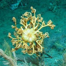
The high definition ROV-mounted video captured a number of 'firsts' in Irish waters, including a species of octocoral of the genus Corallium, which grows into huge fans with a delicate porcelain-like skeleton, and a species of black coral different to others described to date, which may prove to be an entirely new species.

The survey confirmed Irish deep-waters as a haven for these rare and delicate deep-sea black corals. The team of scientists also reported areas of potential 'sponge reef' on the Rockall Bank, a highly unusual accumulation of living and dead sponges forming a complex habitat for many other creatures. Such formations are very rare and have previously only been recorded in Canadian waters.

Cold water coral reefs are ecosystems that host a diverse range of marine animals including sea fans, sponges, worms, starfish, crustaceGorgonocephalus - An Ophiuroid Basket starans and a variety of fish species, making them vitally important habitats for marine biodiversity. These fragile deepwater reefs are commonly associated with topographic features subject to strong bottom currents, for example continental margins, seamounts and mid-ocean ridges, because as filter feeders, the corals depend on suspended food particulate matter. The high resolution bathymetric dataset acquired as part of the national seabed mapping programme –Integrated Mapping For the Sustainable Development of Ireland's Marine Resource (INFOMAR) - was used to target potential locations of reef habitat for this survey by identifying specific seabed morphological features likely to support cold water coral. The last two decades have seen a dramatic increase in our understanding of the cold water coral reef ecosystems, their susceptibility to environmental change, and their low resilience to human impact.

Chief Scientist on the SeaRover survey, David O'Sullivan, Marine Institute said: "We are very pleased to discover what appear to be new coral species and a rare sponge reef, neither of which have been previously documented in Irish waters. These sensitive habitats are very important and this study is key to getting a better understanding of Irelands' deep sea. Our key objective is to discover, protect and monitor Ireland's rich offshore marine biodiversity so we can manage our marine resources effectively. Without a knowledge of what lives on our seabed we are at risk of never fully understanding and appreciating Ireland's invaluable marine environment."

Dr Kerry Howell, Plymouth University said: "This is the first time I have seen a sponge reef like this in nearly 20 years of studying the deep NE Atlantic. This is an important find. Sponges play a key role in the marine ecosystem providing habitat for other species and recycling nutrients. They may even be a source of new antibiotics. These new data will help ROV Holland 1. Picture Credit Aodhan Fitzgeraldus to better understand where and why these reefs occur."

Prof. Louise Allcock, NUI Galway, who is funded by Science Foundation Ireland and the Marine Institute to study the pharmaceutical potential of deep-sea corals and sponges added: 'This project highlights collaboration and cooperation between Irish and international marine scientists, helping us to further our understanding of these sensitive ecosystems and has also been able to provide training opportunities and sea-going experience for young scientists.

The 'SeaRover' survey is the second of three planned expeditions jointly funded by the Irish Government and the EU's European Maritime and Fisheries Fund (EMFF). The cross government initiative is supported by the Department of Agriculture, Food and Marine, Department of Culture, Heritage and Gaeltacht, and Department of Communications, Climate Action and Environment (DCCAE) as part of the Marine Institute's implementation of the Marine Biodiversity scheme.

Survey operations were coordinated and led by the DCCAE funded INFOMAR programme, which is a joint venture between the Geological Survey Ireland and the Marine Institute. This year's expedition extended the habitat exploration area to the Rockall Bank, the farthest offshore extent of Ireland's Economic Exclusive Zone. Scientific experts onboard to witness the exciting findings were from the Marine Institute, National Parks and Wildlife Service, National University of Ireland Galway and Plymouth University.

Published in Marine Wildlife

#MarineScience - The Atlantic Ocean: Our Unknown Treasure was on the agenda at the annual meeting of the American Association for the Advancement of Science (AAAS) in San Jose, California on Saturday 14 February.

Marine Institute chief executive Dr Peter Heffernan joined European Commission officials and leading scientists from the USA, Europe and Canada to discuss how to explore the largely unknown Atlantic Ocean; how new technologies can help us to challenge our understanding of the planet; and how new observation and visualisation tools can improve what we know about the seabed and inform science to help shape future marine policy.

The event built on the Galway Statement on Atlantic Ocean Research Co-operation signed at the Marine Institute in May 2013 by representatives from the EU, Canada and the US, launching an Atlantic Ocean Research Alliance.

Its goals are to better understand the Atlantic and the Arctic, to study the interplay between them, particularly relating to climate change, and to promote sustainable management of their resources.

Speaking about the event, Dr Heffernan said: "It's an exciting time, as all sides - European, US and Canadian - have shown engagement, planning and commitment to driving the Atlantic Ocean Research Alliance forward and preparing joint actions.

"There are very real global challenges to be tackled, and there is strong momentum now to create significant benefits such as better ecosystem assessments and forecasts and deeper understandings of vulnerabilities and risks.

"These transatlantic collaborations will also help to generate new tools to increase resilience and adaptation and to conserve our rich biodiversity. We also really need to foster public understanding of how ocean science and observation will address pressing issues for citizens and for the environment."

Dr Heffernan concluded: "The AAAS meeting gave an opportunity to see some of the collaborations that are undertaken in the Atlantic Ocean and discuss challenges for future research, technological developments, mapping and imaging as well as research co-operation across the Atlantic."

Published in Marine Science

#GhostShip - It was an unsettling discovery for a Donegal skipper to happen upon a deserted yacht drifting in the Atlantic Ocean last week.

As BBC News reports, the unmanned vessel materialised in fog off Downings harbour in the north-west of the county, evoking memories of the famous Mary Celeste.

Fearing the worst, local charter boat operator Michael McVeigh sent two divers abroad to investigate, and all they found were rotting food and an e-mail address left on a note on the table.

But the mystery was soon solved after McVeigh contacted Malin Head coastguard - who confirmed that the yacht's owner had been rescued some 600 miles west of Galway.

The yachtsman had been sailing on a "dream trip" from his home in the Azores towards Iceland when he encountered difficulties and used his satellite phone to call for help.

He was later picked up by a passing freighter, leaving his yacht to drift.

BBC News has more on the tale here.

Published in News Update

#MarineScience - Galway Bay FM reports that the Marine Institute in Galway is to become one of the world's leading marine research centres.

The news comes in the wake of a groundbreaking deal signed in Galway on Friday afternoon (24 May) between the EU, the US and Canada to join forces on Atlantic Ocean research, as previously reported on Afloat.ie.

All partners have agreed to commit to funding to study the interplay of the Atlantic with the Arctic Ocean, and discover ways that research on the oceans and marine wildlife can contribute to scientific advances in other areas.

Meanwhile, a monitoring system for waste waters is among the projects that will benefit from a near €1 million in funding from the Science Foundation.

Research Minister Seán Sherlock announced the funding for projects at NUI Galway that is hoped to deliver "commercialisation of research in a range of areas".

Published in Marine Science

#KERRY OIL - Oil exploration firm Petrel Resources has announced it has found as much as one billion barrels of oil off the coast of Co Kerry.

The Irish Independent reports on the findings by the Dublin-based company which show enormous reserves of oil in the Porcupine Basin off the south-west coast.

As previously reported on Afloat.ie, the company said in September that it has identified a number of targets across the more than 1,400 sq km area of the Atlantic Ocean west of Dursey Island.

Technical studies conducted then on blocks in the northern and eastern parts of the basin for reservoir sands were described as "encouraging".

Now Petrel says that computer analysis shows several oil fields stacked in layers that could be tapped by a smaller number of oil wells.

The distance from shore - approximately 200km - plus the location of the oil reserves beneath 1km of water and a further 3km of rock present some difficulties, but new techniques in the oil industry are allowing previously undrillable resources to be extracted.

Petrel Resources is seeking a partner to invest in drilling for oil, and is preparing its application to the Government for a licence.

The Irish Independent has more on the story HERE.

Published in Coastal Notes

PORT & SHIPPING NEWS - A number of hazardous containers believed to have fallen from a cargo ship this summer are drifting towards Ireland's southwest coast, the Irish Examiner reports.

The containers are said to have slipped from the deck of the MSC Flaminia, a German-registered cargo vessel which caught fire on 14 July in the middle of the Atlantic Ocean, with the loss of two crew and forcing the rest to abandon ship.

The vessel had been en route from North Carolina in the United States to Brememhaven in northern Germany when the incident occurred.

Among the thousands of containers it was carrying were 149 classed as 'dangerous goods', their exact nature not yet confirmed, and it is thought some of these are among the containers that fell into the sea and went missing as the ship listed in mid-ocean.

As reported by the Maritime Bulletin, there was some speculation as to whether the missing containers slipped off deck or were jettisoned.

The containers have since appeared in the main cargo shipping lanes off the southwest coast, posing a danger to transatlantic vessels.

Operations have already begun to retrieve the containers and tow them into Castletownbere in West Cork.

The Irish Examiner has more on the story HERE.

Published in Ports & Shipping

#KAYAKING - A father-and-son duo from north Co Dublin will shortly embark on an epic kayak paddle from Dublin to Donegal, the Fingal Independent reports.

Dermot Higgins and his son Fionn, from Rush, will attempt to kayak from Dublin Port to the Atlantic Ocean at Ballyshannon - a distance of some 330km - by way of the Royal Canal, the River Shannon and Lough Erne.

The Higgins' - who believe they are the first to attempt such a feat - will be completely self-sufficuent for the duration of the challenge, which is hoped to raised funds for the Rush Open Organisation for Transition Status (ROOTS), a charity that intends to help communities reduce their carbon footprint and face up to environmental challenges by encouraging sustainability.

The Fingal Independent has more on the story HERE.

Published in Kayaking
Page 1 of 2

General Information on using Waterways Ireland inland navigations

Safety on the Water

All users of the navigations are strongly recommended to make themselves aware of safety on the water for whatever activity they are involved in and to read the advice offered by the various governing bodies and by:

The Dept. of Transport, Ireland: www.gov.ie/transport and The Maritime and Coastguard Agency, UK, The RNLI – Water Safety Ireland for information in terms of drowning prevention and water safety.

Registration of Vessels

All vessels using the Shannon Navigation, which includes the Shannon-Erne Waterways and the Erne System must be registered with Waterways Ireland. Only open undecked boats with an engine of 15 horsepower or less on the Shannon Navigation, and vessels of 10 horsepower or less on the Erne System, are exempt. Registration is free of charge.

Craft registration should be completed online at: https://www.waterwaysireland.org/online-services/craft-registration

Permits for use of the Grand and Royal Canals and the Barrow Navigation

All vessels using the Grand and Royal Canals and the Barrow Navigation must display appropriate valid Permit(s) i.e A Combined Mooring and Passage Permit (€126) and if not intending to move every five days, an Extended Mooring Permit (€152).

Permit applications should be completed online at: https://www.waterwaysireland.org/online-services/canal-permits

Passage on the Royal and Grand Canals – Dublin Area

For boat passage through the locks east of Lock 12 into / out of Dublin on either the Royal or Grand Canals, Masters are requested to contact the Waterways Ireland Eastern Regional Office (M-F 9.30am-4.30pm) on tel: +353(0)1 868 0148 or email [email protected] prior to making passage in order to plan the necessary lock-keeping assistance arrangements.

On the Grand Canal a minimum of two days notice prior to the planned passage should be given, masters should note that with the exception of pre-arranged events, a maximum of 2 boats per day will be taken through the locks, travelling either east or west.

Movements in or out of the city will be organised by prior arrangement to take place as a single movement in one day. Boaters will be facilitated to travel the system if their passage is considered to be safe by Waterways Ireland and they have the valid permit(s) for mooring and passage.

Newcomen Lifting Bridge

On the Royal Canal two weeks’ notice of bridge passage (Newcomen Lifting Bridge) is required for the pre-set lift date, and lock assistance will then also be arranged. A minimum of 2 boats is required for a bridge lift to go ahead.

Waterways Ireland Eastern Regional Office (Tel: +353(0)1 868 0148 or [email protected] ) is the point of contact for the bridge lift.

A maximum number of boats passing will be implemented to keep to the times given above for the planned lifts (16 for the Sat / Sun lifts & 8 for the weekday lifts). Priority will be given on a first come first served basis.

On day of lift, boaters and passengers must follow guidance from Waterways Ireland staff about sequence of passage under bridge & through Lock 1, and must remain within signed and designated areas.

Events Held on the Waterways

All organised events taking place on the waterways must have the prior approval of Waterways Ireland. This is a twelve week process and application forms must be accompanied with the appropriate insurance, signed indemnity and risk assessment. The application should be completed on the Waterways Ireland events page at :

https://www.waterwaysireland.org/online-services/event-approval

Time Limits on Mooring in Public Harbours

On the Shannon Navigation and the Shannon-Erne Waterway craft may berth in public harbours for five consecutive days or a total of seven days in any one month.

On the Erne System, revised Bye Laws state that: No master or owner shall permit a vessel, boat or any floating or sunken object to remain moored at or in the vicinity of any public mooring, including mooring at any other public mooring within 3 kilometres of that location, for more than 3 consecutive days and shall not moor at that same mooring or any other public mooring within 3 kilometres of that location within the following 3 consecutive days without prior permission by an authorised official.

Winter Mooring on the Shannon Navigation and Shannon Erne Waterway

Winter mooring may be availed of by owners during the period 1 Nov to 31 Mar by prior arrangement and payment of a charge of €63.50 per craft. Craft not availing of Winter Mooring must continue to comply with the “5 Day Rule”. Winter Mooring applications should be completed online at : https://www.waterwaysireland.org/online-services/winter-moorings-booking

Owners should be aware that electricity supply and water supply to public moorings is disconnected for the winter months. This is to protect against frost damage, to reduce running costs and to minimise maintenance requirements during the winter months.

Vessel owners are advised that advance purchasing of electricity on the power bollards leading up to the disconnection date should be minimal. Electricity credit existing on the bollards will not be recoverable after the winter decommissioning date. Both services will be reinstated prior to the commencement of the next boating season.

Smart Cards

Waterways Ireland smart cards are used to operate locks on the Shannon Erne Waterway, to access the service blocks, to use the pump-outs along the navigations, to avail of electrical power at Waterways Ireland jetties.

Berthing in Public Harbours

Masters are reminded of the following:

  • Equip their vessel with mooring lines of appropriate length and strength and only secure their craft to mooring bollards and cleats provided for this purpose.
  • Ensure the available berth is suitable to the length of your vessel, do not overhang the mooring especially on finger moorings on floating pontoon moorings.
  • Ensure mooring lines, electric cables and fresh water hoses do not create a trip hazard on public jetties for others users.
  • Carry sufficient fenders to prevent damage to your own vessel, other vessels and WI property.
  • Allow sufficient space between your vessel and the vessel ahead /astern (c.1m) for fire safety purposes and /or to recover somebody from the water.
  • Do not berth more than two vessels side by side and ensure there is safe access/egress at all times between vessels and onto the harbour itself.
  • Do not berth in such a way to prevent use of harbour safety ladders, slipways or pump-outs.
  • Do not allow the bow of your vessel to overhang the walkway of a floating mooring thus creating a hazard for others with an overhanging anchor or bow fendering.
  • Animals are not allowed to be loose or stray at any time.
  • Harbour and jetty infrastructure such as railings, power pedestals, fresh water taps, electric light poles, safety bollards, ladders etc are not designed for the purpose of mooring craft , they will not bear the strain of a vessel and will be damaged.
  • At Carrybridge on the Erne System, Masters of vessels are not permitted to use stern on mooring. Masters of vessels must use the mooring fingers for mooring of vessels and for embarkation / disembarkation from vessels.

Passenger Vessel Berths

Masters of vessels should not berth on passenger vessel berths where it is indicated that an arrival is imminent. Passenger vessels plying the navigations generally only occupy the berths to embark and disembark passengers and rarely remain on the berths for extended periods or overnight.

Lock Lead-in Jetties

Lead-in jetties adjacent to the upstream and downstream gates at lock chambers are solely for the purpose of craft waiting to use the lock and should not be used for long term berthing.

Vessel Wake

Vessel wake, that is, the wave generated by the passage of the boat through the water, can sometimes be large, powerful and destructive depending on the hull shape and engine power of the vessel. This wake can be detrimental to other users of the navigation when it strikes their craft or inundates the shoreline or riverbank. Masters are requested to frequently look behind and check the effect of their wake / wash particularly when passing moored vessels, on entering harbours and approaching jetties and to be aware of people pursuing other activities such as fishing on the riverbank.

Speed Restriction

A vessel or boat shall not be navigated on the Shannon Navigation at a speed in excess of 5 kph when within 200 metres of a bridge, quay, jetty or wharf, when in a harbour or canal or when passing within 100 metres of a moored vessel or boat.

Vessels navigating the Shannon-Erne Waterway should observe the general 5 kph speed limit which applies along the waterway. This is necessary in order to prevent damage to the banks caused by excessive wash from vessels.

Vessels navigating the Erne System should observe the statutory 5kt / 6mph / 10kph speed limit areas.

A craft on the Royal and Grand canals shall not be navigated at a speed in excess of 6km per hour.

A craft on the Barrow Navigation shall not be navigated at a speed in excess of 11km per hour except as necessary for safe navigation in conditions of fast flow.

Bank Erosion

Narrow sections of all the navigations are particularly prone to bank erosion due to the large wash generated by some craft. Masters are requested to be vigilant and to slow down to a speed sufficient to maintain steerage when they observe the wash of their craft inundating the river banks.

Unusual Waterborne Activity

Unusual waterborne vessels may be encountered from time to time, such as, hovercraft or amphibious aircraft / seaplanes. Masters of such craft are reminded to apply the normal “Rule of the Road” when they meet conventional craft on the water and to allow extra room to manoeuvre in the interest of safety.

Sailing Activity

Mariners will encounter large numbers of sailing dinghies from late June to August in the vicinity of Lough Derg, Lough Ree and Lower Lough Erne. Sailing courses are marked by yellow buoys to suit weather conditions on the day. Vessels should proceed at slow speed and with due caution and observe the rules of navigation when passing these fleets, as many of the participants are junior sailors under training.

Rowing

Mariners should expect to meet canoes and vessels under oars on any part of the navigations, but more so in the vicinity of Athlone, Carrick-on-Shannon, Coleraine, Enniskillen and Limerick. Masters are reminded to proceed at slow speed and especially to reduce their wash to a minimum when passing these craft as they can be easily upset and swamped due to their very low freeboard and always be prepared to give way in any given traffic situation.

Canoeing

Canoeing is an adventure sport and participants are strongly recommended to seek the advice of the sport’s governing bodies i.e Canoeing Ireland and the Canoe Association of Northern Ireland, before venturing onto the navigations.

Persons in charge of canoes are reminded of the inherent danger to these craft associated with operating close to weirs, sluice gates, locks and other infrastructure particularly when rivers are in flood and large volumes of water are moving through the navigations due to general flood conditions or very heavy localised precipitation e.g. turbulent and broken water, stopper waves. Shooting weirs is prohibited without prior permission of Waterways Ireland.

Canoeists should check with lockkeepers prior entering a lock to ensure passage is done in a safe manner. Portage is required at all unmanned locks.

Canoe Trail Network – "Blueways"

Masters of powered craft are reminded that a canoe trail network is being developed across all navigations and to expect more organised canoeing along these trails necessitating slow speed and minimum wash when encountering canoeists, rowing boats etc

Rockingham and Drummans Island Canals – Lough Key

It is expected that work on Rockingham and Drummans Island Canals on Lough Key will be completed in 2021. Access to these canals will be for non-powered craft only, eg canoes, kayaks, rowing boats.

Fast Powerboats and Personal Watercraft (Jet Skis)

Masters of Fast Powerboats (speed greater than 17kts) and Personal Watercraft (i.e.Jet Skis) are reminded of the inherent dangers associated with high speed on the water and especially in the confines of small bays and narrow sections of the navigations. Keeping a proper look-out, making early alterations to course and /or reducing speed will avoid conflict with slower vessels using the navigation. Personal Watercraft are not permitted to be used on the canals.

Towing Waterskiers, Wakeboarders, Doughnuts etc

Masters of vessels engaged in any of these activities are reminded of the manoeuvring constraints imposed upon their vessel by the tow and of the added responsibilities that they have to the person(s) being towed. These activities should be conducted in areas which are clear of conflicting traffic. It is highly recommended that a person additional to the master be carried to act as a “look-out” to keep the tow under observation at all times.

Prohibition on Swimming

Swimming in the navigable channel, particularly at bridges, is dangerous and is prohibited due to the risk of being run over by a vessel underway in the navigation.

Age Restrictions on operating of powered craft

In the Republic of Ireland, Statutory Instrument 921 of 2005 provides the legal requirements regarding the minimum age for operating of powered craft. The Statutory Instrument contains the following requirements:

- The master or owner of a personal watercraft or a fast power craft shall take all reasonable steps to ensure that a person who has not attained the age of 16 years does not operate or control the craft

- The master or owner of a pleasure craft powered by an engine with a rating of more than 5 horse power or 3.7 kilowatts shall take all reasonable steps to ensure that a person who has not attained the age of 12 years does not operate or control the craft.

Lifejackets and Personal Flotation Devices (PFDs)

Lifejackets and PFD’s are the single most important items of personal protective equipment to be used on a vessel and should be worn especially when the vessel is being manoeuvred such as entering / departing a lock, anchoring, coming alongside or departing a jetty or quayside.

In the Republic of Ireland, Statutory Instrument 921 of 2005 provides the legal requirements regarding the wearing of Personal Flotation Devices. The Statutory Instrument contains the following requirements:

- The master or owner of a pleasure craft (other than a personal watercraft) shall ensure, that there are, at all times on board the craft, sufficient suitable personal flotation devices for each person on board.

- A person on a pleasure craft (other than a personal watercraft) of less than 7 metres length overall shall wear a suitable personal flotation device while on board an open craft or while on the deck of decked craft, other than when the craft is made fast to the shore or at anchor.

- The master or owner of a pleasure craft (other than a personal watercraft) shall take all reasonable steps to ensure that a person who has not attained the age of 16 years complies with paragraph above.

- The master or owner of a pleasure craft (other than a personal watercraft), shall take all reasonable steps to ensure that a person who has not attained the age of 16 years wears a suitable personal flotation device while on board an open craft or while on the deck of a decked craft other than when it is made fast to the shore or at anchor.

- The master or owner of a pleasure craft (other than a personal watercraft) shall take all reasonable steps to ensure that a person wears a suitable personal flotation device, at all times while – (a) being towed by the craft, (b) on board a vessel or object of any kind which is being towed by the craft.

Further information is available at: http://www.irishstatutebook.ie/eli/2005/si/921/made/en/print

Firing Range Danger Area – Lough Ree

The attention of mariners is drawn to the Irish Defence Forces Firing Range situated in the vicinity of buoys No’s 2 and 3, on Lough Ree on the Shannon Navigation. This range is used regularly for live firing exercises, throughout the year, all boats and vessels should stay clear of the area marked with yellow buoys showing a yellow "X" topmark and displaying the word "Danger".

Shannon Navigation, Portumna Swing Bridge Tolls

No attempt should be made by Masters’ of vessels to pay the bridge toll while making way through the bridge opening. Payment will only be taken by the Collector from Masters when they are secured alongside the jetties north and south of the bridge.

Navigating from Killaloe to Limerick on the Shannon Navigation

The navigation from Killaloe to Limerick involves passage through Ardnacrusha locks, the associated headrace and tailrace and the Abbey River into Limerick City. Careful passage planning is required to undertake this voyage. Considerations include: lock passage at Ardnacrusha, water flow in the navigation, airdraft under bridges on Abbey River in Limerick, state of tide in Limerick

Users are advised to contact the ESB Ardnacrusha hydroelectric power station (00353 (0)87 9970131) 48 hours in advance of commencing their journey to book passage through the locks at Ardnacrusha. It is NOT advised to undertake a voyage if more than one turbine is operating (20MW), due to the increased velocity of flow in the navigation channel, which can be dangerous. To ascertain automatically in real time how many turbines are running, users can phone +353 (0)87 6477229.

For safety reasons the ESB has advised that only powered craft with a capacity in excess of 5 knots are allowed to enter Ardnacrusha Headrace and Tailrace Canals.

Passage through Sarsfield Lock should be booked on +353-87-7972998, on the day prior to travel and it should be noted also that transit is not possible two hours either side of low water.

A Hydrographic survey in 2020 of the navigation channel revealed that the approach from Shannon Bridge to Sarsfield Lock and the Dock area has silted up. Masters of vessels and water users are advised to navigate to the Lock from Shannon bridge on a rising tide one or two hours before High Tide.

Lower Bann Navigation

The attention of all users is drawn to the “Users Code for the Lower Bann”, in particular to that section covering “Flow in the River” outlining the dangers for users both on the banks and in the navigation, associated with high flow rates when the river is in spate. Canoeists should consult and carry a copy of the “Lower Bann Canoe Trail” guide issued by the Canoe Association of Northern Ireland. Users should also contact the DfI Rivers Coleraine, who is responsible for regulating the flow rates on the river, for advisory information on the flow rates to be expected on any given day.

DfI Rivers Coleraine. Tel: 0044 28 7034 2357 Email: [email protected]

Lower Bann Navigation – Newferry – No wake zone

A No Wake Zone exists on the Lower Bann Navigation at Newferry. Masters of vessels are requested to proceed at a slow speed and create no wake while passing the jetties and slipways at Newferry.

Overhead Power Lines (OHPL) and Air draft

All Masters must be aware of the dangers associated with overhead power lines, in particular sailing vessels and workboats with cranes or large air drafts. Voyage planning is a necessity in order to identify the location of overhead lines crossing the navigation.

Overhead power line heights on the River Shannon are maintained at 12.6metres (40 feet) from Normal Summer level for that section of navigation, masters of vessels with a large air draft should proceed with caution and make additional allowances when water levels are high.

If a vessel or its equipment comes into contact with an OHPL the operator should NOT attempt to move the vessel or equipment. The conductor may still be alive or re-energise automatically. Maintain a safe distance and prevent third parties from approaching due to risk of arcing. Contact the emergency services for assistance.

Anglers are also reminded that a minimum ground distance of 30 metres should be maintained from overhead power lines when using a rod and line.

Submarine Cables and Pipes

Masters of vessels are reminded not to anchor their vessels in the vicinity of submarine cables or pipes in case they foul their anchor or damage the cables or pipes. Look to the river banks for signage indicating their presence.

Water Levels - Precautions

Low Water Levels:

When water levels fall below normal summer levels masters should be aware of:

Navigation

To reduce the risk of grounding masters should navigate on or near the centreline of the channel, avoid short cutting in dog-legged channels and navigating too close to navigation markers.

Proceeding at a slow speed will also reduce “squat” effect i.e. where the vessel tends to sit lower in the water as a consequence of higher speed.

Slipways

Reduced slipway length available under the water surface and the possibility of launching trailers dropping off the end of the concrete apron.

More slipway surface susceptible to weed growth requiring care while engaged in launching boats, from slipping and sliding on the slope. Note also that launching vehicles may not be able to get sufficient traction on the slipway once the craft is launched to get up the incline.

Bank Erosion

Very dry riverbanks are more susceptible to erosion from vessel wash.

Lock Share

Maximising on the number of vessels in a lock will ensure that the total volume of water moving downstream is decreased. Lock cycles should be used for vessels travelling each way.

High Water Levels:

When water levels rise above normal summer level masters should be aware of:

Navigation

Navigation marks will have reduced height above the water level or may disappear underwater altogether making the navigable channel difficult to discern.

In narrow sections of the navigations water levels will tend to rise more quickly than in main streams and air draft at bridges will likewise be reduced.

There will also be increased flow rates particularly in the vicinity of navigation infrastructure such as bridges, weirs, locks etc where extra care in manoeuvring vessels will be required.

Harbours and Jetties

Due care is required in harbours and at slipways when levels are at or near the same level as the harbour walkways' as the edge will be difficult to discern especially in reduced light conditions. It is advised that Personal Flotation Devices be worn if tending to craft in a harbour in these conditions.

Slipways

Slipways should only be used for the purpose of launching and recovering of water craft or other objects from the water. Before using a slipway it should be examined to ensure that the surface has sufficient traction/grip for the intended purpose such as launching a craft from a trailer using a vehicle, that there is sufficient depth of water on the slipway to float the craft off the trailer before the concrete apron ends and that the wheels of the trailer do not drop off the edge of the slipway. That life-saving appliances are available in the vicinity, that the vehicle is roadworthy and capable of coping with the weight of the trailer and boat on the incline. It is recommended that slipway operations are conducted by two persons.

Caution to be Used in Reliance upon Aids to Navigation

The aids to navigation depicted on the navigation guides comprise a system of fixed and floating aids to navigation. Prudent mariners will not rely solely on any single aid to navigation, particularly a floating aid to navigation. With respect to buoys, the buoy symbol is used to indicate the approximate position of the buoy body and the ground tackle which secures it to the lake or river bed. The approximate position is used because of the practical limitations in positioning and maintaining buoys in precise geographical locations. These limitations include, but are not limited to, prevailing atmospheric and lake/river conditions, the slope of and the material making up the lake/river bed, the fact that the buoys are moored to varying lengths of chain, and the fact that the buoy body and/or ground tackle positions are not under continuous surveillance. Due to the forces of nature, the position of the buoy body can be expected to shift inside and outside the charted symbol.

Buoys and perches are also moved out of position or pulled over by those mariners who use them to moor up to instead of anchoring. To this end, mariners should always monitor their passage by relating buoy/perch positions with the published navigation guide. Furthermore, a vessel attempting to pass close by always risks collision with a yawing buoy or with the obstruction that the buoy or beacon/perch marks.

Masters of Vessels are requested to use the most up to date Navigation guides when navigating on the Inland Waterways.

Information taken from Special Marine Notice No 1 of 2023