Menu

Ireland's sailing, boating & maritime magazine

Inland afloat headers


Displaying items by tag: Bermuda

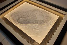
#AmericasCup - Relief chart specialists Latitude Kinsale have been commissioned to create the winners' trophies for the America’s Cup J Class Regatta in Bermuda this month.

Renowned artist Bobby Nash, based in Kinsale in West Cork, created unique 3D charts based on the classic Bermuda Islands map from the UKHO Admiralty archive for the first, second and third prizes in the exclusive regatta for traditional America’s Cup J Class yachts.

The 1950s-era chart shows the archipelago of islands and reefs that comprise the British Overseas Territory in the North Atlantic — the complex structure painstakingly crafted by hand from as many as 2,000 individual pieces.

All three prizes are presented in frames incorporating patent-pending Surround Lighting for optimum illumination of their meticulous details.

“It’s a great honour to be selected as the creator of the overall prizes for the America’s Cup J-Class regatta in Bermuda,” said Bobby Nash. “To have my work appreciated by such a prestigious event and organisation is a reflection of 15 years of experience, design evolution and presentation.”

Latitude Kinsale is renowned worldwide for its soughtt-after 3D charts, framed lighting charts, relief nautical bespoke chart tables and commissions, creating a unique way to appreciate the beauty of the coastline and the sea.

Published in America's Cup

#benainslie – Ben Ainslie Racing were the first America's Cup team both on – and under – the race course waters of the 35th America's Cup last week, when the team conducted an initial training camp in Bermuda.

"It's been great for the team to get out on the water, trying to learn about the venue, the wind direction, the wave states in our 20 foot foiling training boats," commented Team Principal and Skipper, Ben Ainslie. "A huge amount has been learnt, and we can now go back to our design team and start working on developing the final race boat for 2017."

"We turned up here with preconceived ideas about everything," added Sailing Manager, Jono Macbeth. "But it's not until you actually step foot on the island that you get a feel for what's going on. It's going to be completely different compared to last Cup where the wind direction was the same every single day. Here we have seen wind from just about every corner.

"We're just learning all the time. It's invaluable that we are here, especially as the first team on this race course. It's a statement that we are serious about the competition ahead of us. The atmosphere here in anticipation of the America's Cup is incredible," continued Macbeth, "Everyone on the island is so into it. This year is just going to fly by."

"Bermuda is just the most beautiful island," said Ben, "the people are so warm and friendly and are really excited about having the America's Cup here. As a sailing venue it is a real challenge, it is such a tight course and the wind is really variable out here in the middle of the Atlantic."

The major objective of the training camp was to learn the local conditions, and raise foiling skills, but Ben Williams, Head of Strength and Conditioning ensured that the Sailing Team got an extensive work out as well.

"It's been great for us as a sailing team to get away," said Ben. "It's almost been a military operation, our fitness trainer is an ex-Marine and pushing us pretty hard in the morning and evenings. And out on the water we have been sailing and training very hard – but bonding as a team, being away and really focusing on sailing and training."

"I really wanted to make sure that we were using our time wisely out there so we are doing two training sessions in the gym and sailing the boats five or six hours every day," said Macbeth. "There's really not a huge amount of time for the boys to do anything except eat, train and go sailing." Williams unique methods included an opportunity to properly test the depths of Bermudian waters

Published in America's Cup

#AmericasCup - Though the official announcement is still a week away, speculation is growing that Bermuda will be chosen as host for the 2017 America's Cup.

But as Stuff.co.nz reports, the rumour comes as a major blow to San Diego's hopes of welcoming the event.

It seems the issue is simply down to the matter of money, with a tourism chief from the Southern Californian city quoted as saying that "when it came down to it, Bermuda was the destination Larry [Ellison] needed to choose."

Ellison - head of software giant Oracle - was the backer of the current cup holders Oracle Team USA, which won in spectacular fashion last year.

And the financial incentives of hosting the event in the Caribbean tax haven are hard to ignore, even in spite of San Diego's storied legacy in sailing.

Stuff.co.nz has more on the story HERE.

Published in America's Cup

#cruising - Sailing From Bermuda to the Azores on the magnificent yacht Wolfhound III with skipper and lifelong friend Alan McGettigan was an 1,800–mile adventure for Kildare sailor Fin O'Driscoll.

Bermuda is the oldest remaining British overseas territory and the picture postcard town of St. George on the north east corner of the main island is the oldest continuously inhabited English settlement in the new world writes Fin O'Driscoll. The town dates from 1612, when British naval vessel 'Sea Venture' captained by Admiral Sir George Somers was deliberately steered onto a nearby reef to escape a storm. In 1996, the town was twinned with Lyme Regis, in Dorset, the birthplace of Admiral Somers and in 2000, it was designated as a UNESCO World Heritage Site.

Three friends and I travelled from Dublin to St. George in early May where we waited a few days for a boat sailing down from Newport, Rhode Island. Having enjoyed sailing over the years such as cruising in the Med, racing in Dublin bay and coastal trips in the Irish Sea, I knew that this was going to be different. An 1,800 mile crossing from Bermuda to the Azores.

Bermuda has a population of 62,000 and the economy is based on offshore insurance and tourism with the territory enjoying the world's highest GDP per capita for most of the last two decades. The islands have a humid sub-tropical climate and are warmed by the Gulf stream with water temperatures reaching a tepid 22C, making it a wonderful place to swim compared to the chilly Irish Sea. Interestingly, a survivor of the 'Sea Venture' shipwreck was one John Rolfe, whose wife and child died and were buried in Bermuda. Later in Jamestown he married Pocahontas (of Disney fame!), a daughter of the powerful Powhatan, leader of a large confederation of Algonquian tribes in coastal Virginia.

Our vessel, Wolfhound III arrived from Newport on 8th May. She is a magnificent yacht, owned and skippered by Alan McGettigan (RIYC), a lifelong friend from Dublin. I am from Kildare and the three other Irish sailors were William Reilly from Greystones, Barry O'Sullivan and John Campbell from Dublin.

Wolfhound III in St George

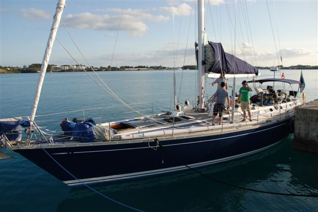
Wolfhound III alongside in St. George

Wolfhound III is a classic Nautor Swan 59' sloop, weighing in at 30 tonnes and sporting an 80 foot mast. She has 4 cabins, can comfortably sleep 10 crew and is complete with a large saloon and galley, a myriad of instrumentation and no less than 14 winches plus 2 grinders on deck! A lot of other boats were arriving for the ARC (Atlantic Rally for Cruisers) 2014 race which was due to leave St. George for the Azores on the 14th so the marina was buzzing. Bermuda is a very expensive place to shop, which we soon found out when we completed our provisioning for 2 weeks at a cost of $2,100 and that excluded any alcohol as she was a dry boat! 

Leaving_St.George_heading_East.jpg

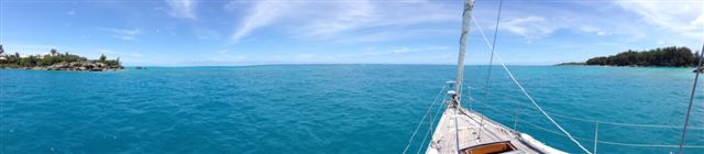
Leaving St. George heading East

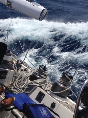
We departed on Sat 10th May at 14:00 in idyllic sailing conditions and enjoyed three days of fine weather, which allowed us get used to the boat, champagne sailing without the champagne! Three of the crew are keen amateur chefs and so we enjoyed fine cuisine on the high seas. As we headed North East to catch the prevailing winds to the Azores, we ran into heavy weather as forecast. We encountered a large low pressure system, so the westerly winds on the south side of the system swept us towards our destination. Barometer readings dropped 15millibars in 6 hours followed by gusts of up to 40knots and 25 foot seas, which made for an exciting and challenging passage.

Alan McGettigan and Fin ODriscoll

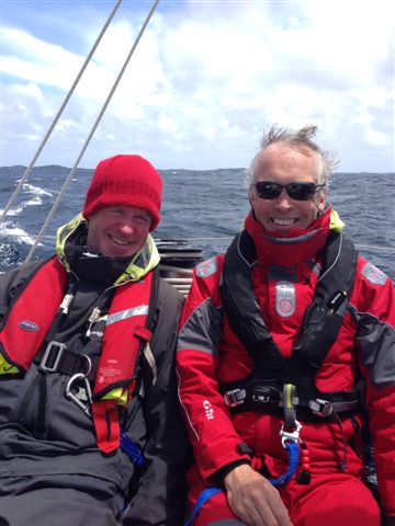
Alan McGettigan (left) and article author and crew man Fin O'Driscoll

The crew in full offshore gear, wore lifejackets at all times and were strapped onto lifelines while on deck or in the cockpit. At night we were on two hour shifts and as the boat was rolling a lot, the culinary delights from the galley were replaced by storm rations; Campbell's soup, tinned ravioli and copious amounts of Red Bull to keep us alert through the long nights.

The gales lasted five days and with winds averaging 25 knots our trip log recorded us surfing down big Atlantic rollers at up to 15 knots, which is fast for a cruising yacht. As is the norm in these weather conditions the boat is tested to the limit and Wolfhound III performed admirably. The port jib sheet parted when a large bow wave hit the fully unfurled headsail and a full knock down at 05:15 one morning rolled everyone out of their bunks (except the two on watch) however she righted herself very quickly. We learned later that British boat Cheeki Rafiki was in the same storm system 400 miles to the west of us and unfortunately her four sailors were lost when the keel sheared off and she capsized before they could release their liferaft.

Sailing_through_big_seas.jpg

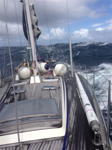
Above and below sailing through big seas

Wolfhound_III_in_big_seas.jpg

In the two weeks at sea, we saw numerous dolphins, porpoises and several breaching whales. The pods of dolphins had a habit of swimming alongside in the early mornings as the sun rose over the bow, a very therapeutic way to start the day. Yes, the Atlantic Ocean is an unbelievably large and empty place as we saw only one other sailboat and three freighters during our voyage. Sailing at night with full canvas up and steering by the stars across the pitch black ocean is an unworldly experience. Combine that with the sparkling luminous green phosphorescence in our wake, a full moon and scudding black clouds for dramatic effect. On day nine, the winds had abated and the sea was millpond calm so we stopped the boat and all dived in (leaving at least one person on board as we had all seen the film Adrift!) for a mid Atlantic swim. A strange sensation considering the nearest land was 2 kms straight down and the nearest coastline was over 1,000 kms away.

Land Ahoy! On day thirteen the Azores appeared on the horizon and we arrived safely in Horta at 19:00, 12 days and 2 hours (including 3 hour time difference from Bermuda) after a distance of 1,900 miles. After tying alongside in the bustling port, we checked in at immigration and immediately proceeded to Peter's Café Sport, a world renowned crossroads and watering hole for transatlantic sailors. The long awaited hot showers had to wait until the following morning as there were celebrations to be had. After 13 days at sea, it took us all a while to get our land legs back and the occasional stumble was not at all due to the pints of Superbock consumed after our dry boat experience.

Happy crew at Horta Azores

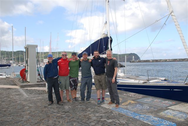
The happy crew quayside in Horta

Horta on the island of Faial has the fourth most visited marina in the world and is overlooked by the very impressive 2,350m Mount Pico on the neighbouring island. The Azores are a Portuguese overseas territory and the nine main islands stretch over 230 miles from Flores in the West to Santa Maria in the East. Officially, the islands were discovered in 1431 by Portuguese explorer Gonçalo Velho Cabrall and Christopher Columbus famously stopped over at Santa Maria (named after his ship) in 1493 on his way back from discovering the New World. During the 18th and 19th century the islands were host to many prominent figures, including Chateaubriand, the French writer who passed through upon his escape to America during the French revolution and Mark Twain published "The Innocents Abroad" in 1869, a travel book, where he described his time in the Azores. The islands straddle an active junction between three of the world's largest tectonic plates (the North American Plate, the Eurasian Plate and the African Plate) resulting in a lot of seismic and volcanic activity in this region of the Atlantic.
After a memorable night celebrating in Horta, the four of us left Wolfhound III and flew back to Dublin via Lisbon. Following the scheduled crew change, the boat has since sailed the final 850 miles onto Lagos in southern Portugal, completing her full transatlantic crossing from the US mainland to Europe. A real marine adventure and sailing the Atlantic is definitely one for the bucket list!

Published in Cruising

#Wolfhound - Four Irish yachtsmen have been rescued from a recently purchased vessel some 70–miles north of Bermuda after it suffered both power and engine failures amid stormy conditions off the northeastern United States.

The 48-foot Swan class sloop Wolfhound, purchased recently by owner/skipper Dalkeyman Alan McGettigan, had departed from Connecticut on 2 February en route to Antigua in the West Indies to compete in the RORC Caribbean 600.

As WM Nixon wrote on Afloat.ie recently, the Wolfhound was expected to eventually call Dun Laoghaire home following its Caribbean adventure.

But according to Bermuda's Bernews website, trouble began when the vessel reportedly suffered a loss of battery power due to the failure of a new inverter charger some 400 miles off the Delaware coast.

This was followed by engine failure a day after departure which left the vessel without communications or navigation systems for eight days.

Between Friday and Saturday the boat reportedly suffered two knockdowns in treacherous weather on the heels of the midwinter storm that recently battered America's northeastern states, and which led McGettigan to activate the on-board emergency beacon.

After a fruitless search by US Coast Guard aircraft, the yachtsmen were eventually located by and transferred to a passing cargo ship, Tetien Trader, which had joined the search effort.

The Wolfhound later sank some 64 miles north of Bermuda.

McGettigan's crew from the Royal Irish Yacht Club in Dun Laoghaire have been confirmed by the club's sailing manager Mark McGibney as Declan Hayes and Morgan Crowe.

Tom Mulligan of the National Yacht Club has been named locally as the fourth crew man on board.

A source close to Afloat.ie says that Hayes telephoned home from the Tetien Trader and confirmed he and the others were being "well looked after" by the Greek crew of the cargo vessel, which is due to land in Gibraltar on 19 February.

A member of the RIYC, Alan McGettigan is an experienced offshore skipper, previously sailing in areas as far afield as the Baltic Sea, the Caribbean, the South China Sea and the Mediterranean, and having competed in past Round Ireland and Dun Laoghaire to Dingle (D2D) races, most recently in the yacht Pride of Dalkey Fuji.

Published in News Update
A yacht that was reported missing in the Atlantic between Bermuda and Ireland sailed safely into port in Co Kerry this afternoon.
As previously reported on Afloat.ie, the Golden Eagle has been at the centre of an air and sea search operation since failing to arrive at its expected destination of Crookhaven in Co Cork on 15 September.
The yacht - crewed by a 69-year-old Norwegian and a 60-year-old New Zealander - had been out of radio contact since leaving Bermuda in mid August.
But a spokesperson for the Irish Coast Guard revealed that the men had intentionally turned off their handheld VHF radio to save battery power until they were close to port.
The boat dropped anchor in Portmagee, Co Kerry at 3pm this afternoon, reporting only minor damage to its sails and rigging due to adverse weather which slowed their progress.

A yacht that was reported missing in the Atlantic between Bermuda and Ireland sailed safely into port in Co Kerry this afternoon.

As previously reported on Afloat.ie, the Golden Eagle has been at the centre of an air and sea search operation since failing to arrive at its expected destination of Crookhaven in Co Cork on 15 September.

The yacht - crewed by a 69-year-old Norwegian and a 60-year-old New Zealander - had been out of radio contact since leaving Bermuda in mid August.

But a spokesperson for the Irish Coast Guard has since revealed that the men intentionally turned off their handheld VHF radio to save battery power until they were close to port.

The boat dropped anchor in Portmagee, Co Kerry at 3pm this afternoon, reporting only minor damage to its sails and rigging due to adverse weather which slowed their progress.

More from RTE here.


Published in Coastguard
An air and sea search operation is underway for a yacht missing en route from Bermuda to Ireland, The Irish Times reports.
The Golden Eagle has been out of contact since leaving port on 21 August. It was due to arrive with its two-man crew - a 69-year-old Norwegian and a 60-year-old New Zealander - at Crookhaven in West Cork last Thursday.
The Irish Coast Guard told the Press Association said that the Naval Service and Air Corps are involved in the search off the south west coast, and ships in the mid-Atlantic have also been asked to try to contact the yacht.
The yacht is described as being 9.8m (32ft) long, white and with a blue trim on the side.

An air and sea search operation is underway for a yacht missing en route from Bermuda to Ireland, The Irish Times reports.

The Golden Eagle has been out of contact since leaving port on 21 August. It was due to arrive with its two-man crew - a 69-year-old Norwegian and a 60-year-old New Zealander - at Crookhaven in West Cork last Thursday.

The Irish Coast Guard told the Press Association said that the Naval Service and Air Corps are involved in the search off the south west coast, and ships in the mid-Atlantic have also been asked to try to contact the yacht.

The yacht is described as being 9.8m (32ft) long, white and with a blue trim on the side.

Published in Coastguard

General Information on using Waterways Ireland inland navigations

Safety on the Water

All users of the navigations are strongly recommended to make themselves aware of safety on the water for whatever activity they are involved in and to read the advice offered by the various governing bodies and by:

The Dept. of Transport, Ireland: www.gov.ie/transport and The Maritime and Coastguard Agency, UK, The RNLI – Water Safety Ireland for information in terms of drowning prevention and water safety.

Registration of Vessels

All vessels using the Shannon Navigation, which includes the Shannon-Erne Waterways and the Erne System must be registered with Waterways Ireland. Only open undecked boats with an engine of 15 horsepower or less on the Shannon Navigation, and vessels of 10 horsepower or less on the Erne System, are exempt. Registration is free of charge.

Craft registration should be completed online at: https://www.waterwaysireland.org/online-services/craft-registration

Permits for use of the Grand and Royal Canals and the Barrow Navigation

All vessels using the Grand and Royal Canals and the Barrow Navigation must display appropriate valid Permit(s) i.e A Combined Mooring and Passage Permit (€126) and if not intending to move every five days, an Extended Mooring Permit (€152).

Permit applications should be completed online at: https://www.waterwaysireland.org/online-services/canal-permits

Passage on the Royal and Grand Canals – Dublin Area

For boat passage through the locks east of Lock 12 into / out of Dublin on either the Royal or Grand Canals, Masters are requested to contact the Waterways Ireland Eastern Regional Office (M-F 9.30am-4.30pm) on tel: +353(0)1 868 0148 or email [email protected] prior to making passage in order to plan the necessary lock-keeping assistance arrangements.

On the Grand Canal a minimum of two days notice prior to the planned passage should be given, masters should note that with the exception of pre-arranged events, a maximum of 2 boats per day will be taken through the locks, travelling either east or west.

Movements in or out of the city will be organised by prior arrangement to take place as a single movement in one day. Boaters will be facilitated to travel the system if their passage is considered to be safe by Waterways Ireland and they have the valid permit(s) for mooring and passage.

Newcomen Lifting Bridge

On the Royal Canal two weeks’ notice of bridge passage (Newcomen Lifting Bridge) is required for the pre-set lift date, and lock assistance will then also be arranged. A minimum of 2 boats is required for a bridge lift to go ahead.

Waterways Ireland Eastern Regional Office (Tel: +353(0)1 868 0148 or [email protected] ) is the point of contact for the bridge lift.

A maximum number of boats passing will be implemented to keep to the times given above for the planned lifts (16 for the Sat / Sun lifts & 8 for the weekday lifts). Priority will be given on a first come first served basis.

On day of lift, boaters and passengers must follow guidance from Waterways Ireland staff about sequence of passage under bridge & through Lock 1, and must remain within signed and designated areas.

Events Held on the Waterways

All organised events taking place on the waterways must have the prior approval of Waterways Ireland. This is a twelve week process and application forms must be accompanied with the appropriate insurance, signed indemnity and risk assessment. The application should be completed on the Waterways Ireland events page at :

https://www.waterwaysireland.org/online-services/event-approval

Time Limits on Mooring in Public Harbours

On the Shannon Navigation and the Shannon-Erne Waterway craft may berth in public harbours for five consecutive days or a total of seven days in any one month.

On the Erne System, revised Bye Laws state that: No master or owner shall permit a vessel, boat or any floating or sunken object to remain moored at or in the vicinity of any public mooring, including mooring at any other public mooring within 3 kilometres of that location, for more than 3 consecutive days and shall not moor at that same mooring or any other public mooring within 3 kilometres of that location within the following 3 consecutive days without prior permission by an authorised official.

Winter Mooring on the Shannon Navigation and Shannon Erne Waterway

Winter mooring may be availed of by owners during the period 1 Nov to 31 Mar by prior arrangement and payment of a charge of €63.50 per craft. Craft not availing of Winter Mooring must continue to comply with the “5 Day Rule”. Winter Mooring applications should be completed online at : https://www.waterwaysireland.org/online-services/winter-moorings-booking

Owners should be aware that electricity supply and water supply to public moorings is disconnected for the winter months. This is to protect against frost damage, to reduce running costs and to minimise maintenance requirements during the winter months.

Vessel owners are advised that advance purchasing of electricity on the power bollards leading up to the disconnection date should be minimal. Electricity credit existing on the bollards will not be recoverable after the winter decommissioning date. Both services will be reinstated prior to the commencement of the next boating season.

Smart Cards

Waterways Ireland smart cards are used to operate locks on the Shannon Erne Waterway, to access the service blocks, to use the pump-outs along the navigations, to avail of electrical power at Waterways Ireland jetties.

Berthing in Public Harbours

Masters are reminded of the following:

  • Equip their vessel with mooring lines of appropriate length and strength and only secure their craft to mooring bollards and cleats provided for this purpose.
  • Ensure the available berth is suitable to the length of your vessel, do not overhang the mooring especially on finger moorings on floating pontoon moorings.
  • Ensure mooring lines, electric cables and fresh water hoses do not create a trip hazard on public jetties for others users.
  • Carry sufficient fenders to prevent damage to your own vessel, other vessels and WI property.
  • Allow sufficient space between your vessel and the vessel ahead /astern (c.1m) for fire safety purposes and /or to recover somebody from the water.
  • Do not berth more than two vessels side by side and ensure there is safe access/egress at all times between vessels and onto the harbour itself.
  • Do not berth in such a way to prevent use of harbour safety ladders, slipways or pump-outs.
  • Do not allow the bow of your vessel to overhang the walkway of a floating mooring thus creating a hazard for others with an overhanging anchor or bow fendering.
  • Animals are not allowed to be loose or stray at any time.
  • Harbour and jetty infrastructure such as railings, power pedestals, fresh water taps, electric light poles, safety bollards, ladders etc are not designed for the purpose of mooring craft , they will not bear the strain of a vessel and will be damaged.
  • At Carrybridge on the Erne System, Masters of vessels are not permitted to use stern on mooring. Masters of vessels must use the mooring fingers for mooring of vessels and for embarkation / disembarkation from vessels.

Passenger Vessel Berths

Masters of vessels should not berth on passenger vessel berths where it is indicated that an arrival is imminent. Passenger vessels plying the navigations generally only occupy the berths to embark and disembark passengers and rarely remain on the berths for extended periods or overnight.

Lock Lead-in Jetties

Lead-in jetties adjacent to the upstream and downstream gates at lock chambers are solely for the purpose of craft waiting to use the lock and should not be used for long term berthing.

Vessel Wake

Vessel wake, that is, the wave generated by the passage of the boat through the water, can sometimes be large, powerful and destructive depending on the hull shape and engine power of the vessel. This wake can be detrimental to other users of the navigation when it strikes their craft or inundates the shoreline or riverbank. Masters are requested to frequently look behind and check the effect of their wake / wash particularly when passing moored vessels, on entering harbours and approaching jetties and to be aware of people pursuing other activities such as fishing on the riverbank.

Speed Restriction

A vessel or boat shall not be navigated on the Shannon Navigation at a speed in excess of 5 kph when within 200 metres of a bridge, quay, jetty or wharf, when in a harbour or canal or when passing within 100 metres of a moored vessel or boat.

Vessels navigating the Shannon-Erne Waterway should observe the general 5 kph speed limit which applies along the waterway. This is necessary in order to prevent damage to the banks caused by excessive wash from vessels.

Vessels navigating the Erne System should observe the statutory 5kt / 6mph / 10kph speed limit areas.

A craft on the Royal and Grand canals shall not be navigated at a speed in excess of 6km per hour.

A craft on the Barrow Navigation shall not be navigated at a speed in excess of 11km per hour except as necessary for safe navigation in conditions of fast flow.

Bank Erosion

Narrow sections of all the navigations are particularly prone to bank erosion due to the large wash generated by some craft. Masters are requested to be vigilant and to slow down to a speed sufficient to maintain steerage when they observe the wash of their craft inundating the river banks.

Unusual Waterborne Activity

Unusual waterborne vessels may be encountered from time to time, such as, hovercraft or amphibious aircraft / seaplanes. Masters of such craft are reminded to apply the normal “Rule of the Road” when they meet conventional craft on the water and to allow extra room to manoeuvre in the interest of safety.

Sailing Activity

Mariners will encounter large numbers of sailing dinghies from late June to August in the vicinity of Lough Derg, Lough Ree and Lower Lough Erne. Sailing courses are marked by yellow buoys to suit weather conditions on the day. Vessels should proceed at slow speed and with due caution and observe the rules of navigation when passing these fleets, as many of the participants are junior sailors under training.

Rowing

Mariners should expect to meet canoes and vessels under oars on any part of the navigations, but more so in the vicinity of Athlone, Carrick-on-Shannon, Coleraine, Enniskillen and Limerick. Masters are reminded to proceed at slow speed and especially to reduce their wash to a minimum when passing these craft as they can be easily upset and swamped due to their very low freeboard and always be prepared to give way in any given traffic situation.

Canoeing

Canoeing is an adventure sport and participants are strongly recommended to seek the advice of the sport’s governing bodies i.e Canoeing Ireland and the Canoe Association of Northern Ireland, before venturing onto the navigations.

Persons in charge of canoes are reminded of the inherent danger to these craft associated with operating close to weirs, sluice gates, locks and other infrastructure particularly when rivers are in flood and large volumes of water are moving through the navigations due to general flood conditions or very heavy localised precipitation e.g. turbulent and broken water, stopper waves. Shooting weirs is prohibited without prior permission of Waterways Ireland.

Canoeists should check with lockkeepers prior entering a lock to ensure passage is done in a safe manner. Portage is required at all unmanned locks.

Canoe Trail Network – "Blueways"

Masters of powered craft are reminded that a canoe trail network is being developed across all navigations and to expect more organised canoeing along these trails necessitating slow speed and minimum wash when encountering canoeists, rowing boats etc

Rockingham and Drummans Island Canals – Lough Key

It is expected that work on Rockingham and Drummans Island Canals on Lough Key will be completed in 2021. Access to these canals will be for non-powered craft only, eg canoes, kayaks, rowing boats.

Fast Powerboats and Personal Watercraft (Jet Skis)

Masters of Fast Powerboats (speed greater than 17kts) and Personal Watercraft (i.e.Jet Skis) are reminded of the inherent dangers associated with high speed on the water and especially in the confines of small bays and narrow sections of the navigations. Keeping a proper look-out, making early alterations to course and /or reducing speed will avoid conflict with slower vessels using the navigation. Personal Watercraft are not permitted to be used on the canals.

Towing Waterskiers, Wakeboarders, Doughnuts etc

Masters of vessels engaged in any of these activities are reminded of the manoeuvring constraints imposed upon their vessel by the tow and of the added responsibilities that they have to the person(s) being towed. These activities should be conducted in areas which are clear of conflicting traffic. It is highly recommended that a person additional to the master be carried to act as a “look-out” to keep the tow under observation at all times.

Prohibition on Swimming

Swimming in the navigable channel, particularly at bridges, is dangerous and is prohibited due to the risk of being run over by a vessel underway in the navigation.

Age Restrictions on operating of powered craft

In the Republic of Ireland, Statutory Instrument 921 of 2005 provides the legal requirements regarding the minimum age for operating of powered craft. The Statutory Instrument contains the following requirements:

- The master or owner of a personal watercraft or a fast power craft shall take all reasonable steps to ensure that a person who has not attained the age of 16 years does not operate or control the craft

- The master or owner of a pleasure craft powered by an engine with a rating of more than 5 horse power or 3.7 kilowatts shall take all reasonable steps to ensure that a person who has not attained the age of 12 years does not operate or control the craft.

Lifejackets and Personal Flotation Devices (PFDs)

Lifejackets and PFD’s are the single most important items of personal protective equipment to be used on a vessel and should be worn especially when the vessel is being manoeuvred such as entering / departing a lock, anchoring, coming alongside or departing a jetty or quayside.

In the Republic of Ireland, Statutory Instrument 921 of 2005 provides the legal requirements regarding the wearing of Personal Flotation Devices. The Statutory Instrument contains the following requirements:

- The master or owner of a pleasure craft (other than a personal watercraft) shall ensure, that there are, at all times on board the craft, sufficient suitable personal flotation devices for each person on board.

- A person on a pleasure craft (other than a personal watercraft) of less than 7 metres length overall shall wear a suitable personal flotation device while on board an open craft or while on the deck of decked craft, other than when the craft is made fast to the shore or at anchor.

- The master or owner of a pleasure craft (other than a personal watercraft) shall take all reasonable steps to ensure that a person who has not attained the age of 16 years complies with paragraph above.

- The master or owner of a pleasure craft (other than a personal watercraft), shall take all reasonable steps to ensure that a person who has not attained the age of 16 years wears a suitable personal flotation device while on board an open craft or while on the deck of a decked craft other than when it is made fast to the shore or at anchor.

- The master or owner of a pleasure craft (other than a personal watercraft) shall take all reasonable steps to ensure that a person wears a suitable personal flotation device, at all times while – (a) being towed by the craft, (b) on board a vessel or object of any kind which is being towed by the craft.

Further information is available at: http://www.irishstatutebook.ie/eli/2005/si/921/made/en/print

Firing Range Danger Area – Lough Ree

The attention of mariners is drawn to the Irish Defence Forces Firing Range situated in the vicinity of buoys No’s 2 and 3, on Lough Ree on the Shannon Navigation. This range is used regularly for live firing exercises, throughout the year, all boats and vessels should stay clear of the area marked with yellow buoys showing a yellow "X" topmark and displaying the word "Danger".

Shannon Navigation, Portumna Swing Bridge Tolls

No attempt should be made by Masters’ of vessels to pay the bridge toll while making way through the bridge opening. Payment will only be taken by the Collector from Masters when they are secured alongside the jetties north and south of the bridge.

Navigating from Killaloe to Limerick on the Shannon Navigation

The navigation from Killaloe to Limerick involves passage through Ardnacrusha locks, the associated headrace and tailrace and the Abbey River into Limerick City. Careful passage planning is required to undertake this voyage. Considerations include: lock passage at Ardnacrusha, water flow in the navigation, airdraft under bridges on Abbey River in Limerick, state of tide in Limerick

Users are advised to contact the ESB Ardnacrusha hydroelectric power station (00353 (0)87 9970131) 48 hours in advance of commencing their journey to book passage through the locks at Ardnacrusha. It is NOT advised to undertake a voyage if more than one turbine is operating (20MW), due to the increased velocity of flow in the navigation channel, which can be dangerous. To ascertain automatically in real time how many turbines are running, users can phone +353 (0)87 6477229.

For safety reasons the ESB has advised that only powered craft with a capacity in excess of 5 knots are allowed to enter Ardnacrusha Headrace and Tailrace Canals.

Passage through Sarsfield Lock should be booked on +353-87-7972998, on the day prior to travel and it should be noted also that transit is not possible two hours either side of low water.

A Hydrographic survey in 2020 of the navigation channel revealed that the approach from Shannon Bridge to Sarsfield Lock and the Dock area has silted up. Masters of vessels and water users are advised to navigate to the Lock from Shannon bridge on a rising tide one or two hours before High Tide.

Lower Bann Navigation

The attention of all users is drawn to the “Users Code for the Lower Bann”, in particular to that section covering “Flow in the River” outlining the dangers for users both on the banks and in the navigation, associated with high flow rates when the river is in spate. Canoeists should consult and carry a copy of the “Lower Bann Canoe Trail” guide issued by the Canoe Association of Northern Ireland. Users should also contact the DfI Rivers Coleraine, who is responsible for regulating the flow rates on the river, for advisory information on the flow rates to be expected on any given day.

DfI Rivers Coleraine. Tel: 0044 28 7034 2357 Email: [email protected]

Lower Bann Navigation – Newferry – No wake zone

A No Wake Zone exists on the Lower Bann Navigation at Newferry. Masters of vessels are requested to proceed at a slow speed and create no wake while passing the jetties and slipways at Newferry.

Overhead Power Lines (OHPL) and Air draft

All Masters must be aware of the dangers associated with overhead power lines, in particular sailing vessels and workboats with cranes or large air drafts. Voyage planning is a necessity in order to identify the location of overhead lines crossing the navigation.

Overhead power line heights on the River Shannon are maintained at 12.6metres (40 feet) from Normal Summer level for that section of navigation, masters of vessels with a large air draft should proceed with caution and make additional allowances when water levels are high.

If a vessel or its equipment comes into contact with an OHPL the operator should NOT attempt to move the vessel or equipment. The conductor may still be alive or re-energise automatically. Maintain a safe distance and prevent third parties from approaching due to risk of arcing. Contact the emergency services for assistance.

Anglers are also reminded that a minimum ground distance of 30 metres should be maintained from overhead power lines when using a rod and line.

Submarine Cables and Pipes

Masters of vessels are reminded not to anchor their vessels in the vicinity of submarine cables or pipes in case they foul their anchor or damage the cables or pipes. Look to the river banks for signage indicating their presence.

Water Levels - Precautions

Low Water Levels:

When water levels fall below normal summer levels masters should be aware of:

Navigation

To reduce the risk of grounding masters should navigate on or near the centreline of the channel, avoid short cutting in dog-legged channels and navigating too close to navigation markers.

Proceeding at a slow speed will also reduce “squat” effect i.e. where the vessel tends to sit lower in the water as a consequence of higher speed.

Slipways

Reduced slipway length available under the water surface and the possibility of launching trailers dropping off the end of the concrete apron.

More slipway surface susceptible to weed growth requiring care while engaged in launching boats, from slipping and sliding on the slope. Note also that launching vehicles may not be able to get sufficient traction on the slipway once the craft is launched to get up the incline.

Bank Erosion

Very dry riverbanks are more susceptible to erosion from vessel wash.

Lock Share

Maximising on the number of vessels in a lock will ensure that the total volume of water moving downstream is decreased. Lock cycles should be used for vessels travelling each way.

High Water Levels:

When water levels rise above normal summer level masters should be aware of:

Navigation

Navigation marks will have reduced height above the water level or may disappear underwater altogether making the navigable channel difficult to discern.

In narrow sections of the navigations water levels will tend to rise more quickly than in main streams and air draft at bridges will likewise be reduced.

There will also be increased flow rates particularly in the vicinity of navigation infrastructure such as bridges, weirs, locks etc where extra care in manoeuvring vessels will be required.

Harbours and Jetties

Due care is required in harbours and at slipways when levels are at or near the same level as the harbour walkways' as the edge will be difficult to discern especially in reduced light conditions. It is advised that Personal Flotation Devices be worn if tending to craft in a harbour in these conditions.

Slipways

Slipways should only be used for the purpose of launching and recovering of water craft or other objects from the water. Before using a slipway it should be examined to ensure that the surface has sufficient traction/grip for the intended purpose such as launching a craft from a trailer using a vehicle, that there is sufficient depth of water on the slipway to float the craft off the trailer before the concrete apron ends and that the wheels of the trailer do not drop off the edge of the slipway. That life-saving appliances are available in the vicinity, that the vehicle is roadworthy and capable of coping with the weight of the trailer and boat on the incline. It is recommended that slipway operations are conducted by two persons.

Caution to be Used in Reliance upon Aids to Navigation

The aids to navigation depicted on the navigation guides comprise a system of fixed and floating aids to navigation. Prudent mariners will not rely solely on any single aid to navigation, particularly a floating aid to navigation. With respect to buoys, the buoy symbol is used to indicate the approximate position of the buoy body and the ground tackle which secures it to the lake or river bed. The approximate position is used because of the practical limitations in positioning and maintaining buoys in precise geographical locations. These limitations include, but are not limited to, prevailing atmospheric and lake/river conditions, the slope of and the material making up the lake/river bed, the fact that the buoys are moored to varying lengths of chain, and the fact that the buoy body and/or ground tackle positions are not under continuous surveillance. Due to the forces of nature, the position of the buoy body can be expected to shift inside and outside the charted symbol.

Buoys and perches are also moved out of position or pulled over by those mariners who use them to moor up to instead of anchoring. To this end, mariners should always monitor their passage by relating buoy/perch positions with the published navigation guide. Furthermore, a vessel attempting to pass close by always risks collision with a yawing buoy or with the obstruction that the buoy or beacon/perch marks.

Masters of Vessels are requested to use the most up to date Navigation guides when navigating on the Inland Waterways.

Information taken from Special Marine Notice No 1 of 2023