


Displaying items by tag: Bluefin Tuna
Record Recaptures of Atlantic Bluefin Tuna in Irish Waters as 2023 Fishing Season Nears End
Inland Fisheries Ireland (IFI) has recorded two rare recaptures of tagged Atlantic bluefin tuna as the angling season for these fish nears its closure on Sunday 12 November.
The first recaptured bluefin was tagged and released originally by skipper Adrian Molloy on 2 October 2020 in Donegal Bay. Three years later, the same fish was caught again on 11 September this year off the north-east coast of Spain.
The second bluefin was originally tagged and released by skipper Tony Santry on 23 August this year off the Kerry coast and recaptured just 22 days later on 14 September off the west French coast. This Atlantic bluefin tuna had travelled a distance of 750km in three weeks, data showed.
Dr William Roche of IFI said: “Atlantic bluefin tuna are leviathans of the sea, and a bucket list species for many anglers.
“For the first time in the five years of this programme, two recaptures have been recorded — that’s two from over 1,600 fish tagged.
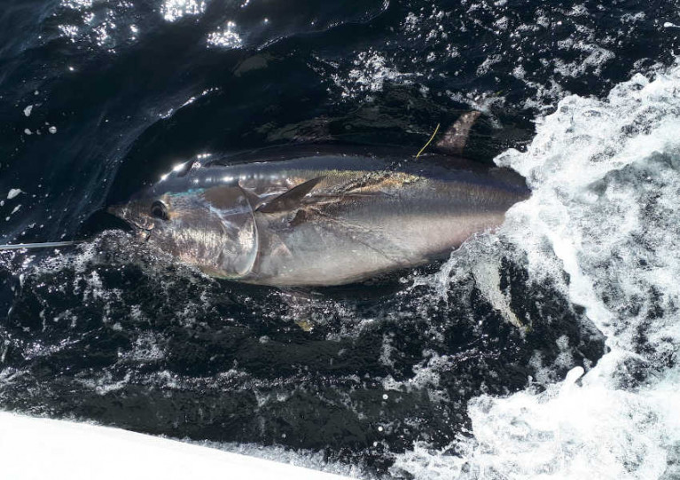
 One of the first two Atlantic bluefin tuna caught of the 2023 Tuna CHART season, captured, tagged and released off the Irish coast in late July
“To date, 1,619 bluefin tuna have been tagged by skippers along the north west, west and south coast of Ireland since the Tuna CHART programme, an inter-agency Government research initiative started in 2019.”
Recreational angling for Atlantic bluefin tuna is technically prohibited in Ireland. However, under the Tuna CHART programme, authorised charter skippers can catch, tag and release bluefin during the open season with the help of anglers as ‘citizen scientists’ on board.
This scientific tuna fishery targets the largest tuna species to collect information on their sizes, and where and when they occur in Irish waters.
The largest tuna tagged to date in the programme was 2.75m long, and weighed an estimated 372kg.
In 2022, 382 Atlantic bluefin tuna were caught, tagged, and released around the Irish coast by authorised skippers.
Skippers willingly provide their expertise to the programme and can charge anglers for bluefin tuna trips on their vessels.
Measuring, tagging and releasing bluefin tuna is carried out in the water alongside the boat, which progresses slowly at speeds of 2-3 knots, to ensure the fish remains in the best possible condition.
Bluefin are caught in area that extends from approximately 1km from the shore out to a maximum of about 20km.
Marine Minister Calls to Reopen Discussions on Internal Allocation of EU Bluefin Tuna Quota
Marine Minister Charlie McConalogue attended the Agriculture and Fisheries Council in Luxembourg on Monday (23 October) where there were a number of important fisheries items on the agenda.
Among those were an exchange of views on the EU priorities for the upcoming ICCAT (International Commission for the Conservation of Atlantic Tuna) meeting in Cairo.
Minister McConalogue welcomed the positive stock assessment for northern albacore tuna and the significant increase on the current total allowable catch.
He added that Ireland “calls to reopen a discussion within the EU on internal reallocation of the EU’s bluefin tuna quota in light of the new management plan and the recent adjustment to the ICCAT sharing arrangements”.
Another important aspect of the meeting were contributions from member states on the ongoing negotiations in respect of the Baltic Sea 2024 Fishing Opportunities Regulation.
The minister welcomed the progress that had been made by participating member states on the Baltic Sea 2024 Fishing Opportunities Regulation.
Minister McConalogue will attend the Joint Oireachtas Committee on Agriculture Food and the Marine later this Wednesday (25 October) to present the Sustainability Impact Assessment in relation to 2024 fishing opportunities for Ireland.
This is an important step in Ireland’s preparation for the annual fisheries negotiations and is an opportunity for the minister to hear the views of the Oireachtas Committee before the negotiations commence later this month.
A Co Meath angler has been found guilty of two breaches of fisheries legislation for illegal fishing in an area around the Blasket Islands.
Joseph Foley from Trim, Co Meath was observed trolling for protected bluefin tuna off the Kerry coastline using specialist gear including spreader bars, squid lures and game fishing reels.
Fisheries officers boarded his vessel, the Evie Rose, at the mouth of Valentia Harbour on 27 August 2022 and located the equipment stored throughout the boat.
Foley pleaded guilty to two charges: surface trolling from a vessel used for sea angling targeting or catching any species fish under Bye-Law No 981 of 2020 (Control of Sea Angling Method for Certain Species of Fish); and using a boat as an aid to the commission of an offence, contrary to the Fisheries (Consolidation) Act 1959 as amended.
He was convicted at Caherciveen District Court on Thursday 8 June and fined €400 for the breach of Bye-Law No 981/2020. The second charge was marked “taken into consideration”.
An order of forfeiture was made of the fishing gear seized and Foley was ordered to pay €200 costs.
The court was informed of the seriousness of the offences and that recreational fishing for Atlantic bluefin tuna in Irish waters is prohibited unless licensed as part of a limited and tightly controlled ongoing research project.
The court heard that Foley had no previous convictions and had cooperated with fisheries officers.
Commenting after the case, Sean Long, director of the South-Western River Basin District at Inland Fisheries Ireland (IFI) said: “Recreational fishing for Atlantic bluefin tuna in all Irish waters is strictly prohibited.
“This was an intelligence-led operation. It enabled officers to detect and intercept the Evie Rose and ensure that these important species are protected from illegal fishing.
“A tightly controlled licensed research project, studying the movements and abundance of Atlantic bluefin tuna (Tuna CHART) has been underway between July and November annually since 2019. Such illegal angling jeopardises the potential for a viable recreational fishery in the future.
“I wish to acknowledge the vigilance and perseverance of IFI local fisheries officers in this instance.
“Inland Fisheries Ireland continues to encourage members of the public and anglers to report illegal fishing, water pollution, fish kills, or fish in distress, to its confidential 24/7 phone number, 0818 34 74 24.”
Three men have been found guilty of illegally fishing for Atlantic bluefin tuna off Baltimore Harbour in West Cork.
Brian Hassett from Monkstown, Co Cork; Barry Keohane from Blackrock, Co Cork; and Conor Jones of Kildinan, Co Cork were found guilty of illegally fishing for Atlantic bluefin tuna in waters south of Baltimore Harbour on 10 October 2022.
All three entered guilty pleas at Skibbereen District Court at a hearing on Tuesday 14 March.
The court heard evidence from Inland Fisheries Ireland (IFI) officer David Lordan, who said he observed the men using a spreader-bar lure system for around 70 minutes before their vessel entered Baltimore Harbour.
Despite an application for a return of the seized fishing gear, the court granted Forfeiture Orders in respect of all items seized.
Details were also presented of the importance of protecting Atlantic bluefin tuna and the research programme Tuna CHART, a catch-and-release tagging programme gathering scientific data through licensed recreational charters since 2019.
Hassett was found guilty of a breach of Section 285(a) of the Fisheries (Consolidation) Act 1959 and fined €1,000. He was also found guilty of breaches of Article 4 (a) and 4 (b) of Bye Law 981 of 2020, which were taken into consideration.
Keohane and Jones were found guilty of breaches of Article 4 (a) and 4 (b) of the 2020 Bye Law, and both men received the benefit of the Probation of Offenders Act on bonds of €5,000 each for a period of three years.
Commenting after the case, Sean Long, director of the South-Western River Basin District at IFI said: “I want to praise the vigilance of the fisheries officers involved in this operation.
“Illegal fishing for Atlantic bluefin tuna jeopardises the potential future for sustainable catch-and-release angling fishery, currently valued at €1 million annually, for professional skippers and for rural coastal communities.
“I continue to encourage members of the public to report incidents of illegal fishing, water pollution and fish kills, to Inland Fisheries Ireland’s 24-hour confidential hotline number on 0818 34 74 24.”
Bluefin Tuna ‘Catch-Tag-Release’ Scientific Survey Programme for 2023 Opens for Charter Skippers
Ireland’s Tuna CHART bluefin tuna sea angling survey programme for 2023 has opened for charter skippers to apply.
Anglers in Ireland will once again have the opportunity to catch and release bluefin tuna in 2023 through the continuation of the Tuna CHART (CatcH And Release Tagging) programme that has been in operation around our coast since 2019.
Experienced charter skippers are now invited to apply to take part in this year’s Atlantic bluefin tuna scientific survey programme of Irish waters.
Building on the successes of the Tuna CHART programmes of 2019-2022, this scientific data collection catch-and-release fishery for Ireland will again operate in 2023.
A maximum of 25 authorisations may be granted to qualifying angling charter vessel skippers around the Irish coast for this fishery, which opens on 1 July and closes on 12 November.
The Tuna CHART programme is a collaborative scientific programme between Inland Fisheries Ireland (IFI) and the Marine Institute in partnership with the Sea Fisheries Protection Authority, Department of Agriculture, Food and the Marine (DAFM) and Department of Environment, Climate and Communications (DECC).
Between 2019 and 2022, some 1,500 Atlantic bluefin tuna were caught, tagged, measured and released off the Irish coast by authorised charter skippers. The largest tuna tagged to date in the programme was 2.75 metres, weighing an estimated 372kg.
All tuna were carefully managed in the water alongside the charter vessel, subject to strict guidelines set by the Tuna CHART programme, and all were released alive.
Data from the tagging programme have been collated by the partnership for reporting to the International Commission for the Conservation of Atlantic Tuna (ICCAT).
The core aim of the Tuna CHART programme is to collect data and tag these large fish, which is underpinned by ensuring good fish welfare, leading to successful release of the bluefin tuna.
Authorised skippers will be required to collect data on every bluefin trip undertaken and each bluefin tuna they catch, tag and release and their angling and data recording expertise is an important part of the overall survey programme. They will also be required to have high specification rods, reels and line in advance of the open season in order to ensure that the fish is brought alongside the vessel to be measured and tagged in the water in a timely manner.
Anglers will have an opportunity to participate in this fishery and contribute to this important scientific study by chartering and fishing from authorised vessels only.
Unauthorised vessels are not permitted to target or catch Bluefin tuna and any unauthorised person found to be targeting Bluefin tuna is liable to prosecution.
Experienced charter skippers are being invited to apply to join the 2023 Tuna CHART programme between Tuesday 21 March and Tuesday 4 April by filling out an application form online at www.fisheriesireland.ie/bluefin.
Marine Minister to Seek Bluefin Tuna Quota for Ireland, After Britain Awarded Share
Minister for Marine Charlie McConalogue has promised to seek a quota of bluefin tuna for Ireland at the December EU fisheries council.
Large numbers of bluefin tuna have been reported by fishermen off the Irish west coast in recent years, but Ireland has no quota to catch the species- apart from a licensed catch and release programme for deep sea angling.
The tuna shoals have attracted Japanese and Korean vessels to the Irish coast outside the 200-mile EEZ, while Croatia, Cyprus, France, Greece, Italy, Malta, Portugal, and Spain are among EU member states which have quotas.
Britain has now been awarded a quota of 63 tonnes of bluefin tuna for 2023-2025
Mr McConalogue noted that an increased total allowable catch of bluefin tuna has been agreed as part of a new management plan adopted at the recent International Commission for the Conservation of Atlantic Tunas (ICCAT) meeting.
“Following discussions on this new management plan, the UK was granted an additional 15 tonne of bluefin quota and now has a quota of 63 tonnes of bluefin tuna for 2023-2025,” he said.
He said that Ireland had made clear to EU member states and the European Commission at EU internal meetings that Ireland considers that there is a case for an allocation of part of the increase in the bluefin tuna quota to be made available to Ireland for a targeted fishery.
“Given the prevalence of bluefin tuna in Ireland's EEZ, this is a request that we wish to be considered at council,” he said.
“I have therefore requested the opening of discussions at EU level to progress our case and I will be making a formal statement to this effect at next week's December Agrifish Council,” he said.
The EU share of global bluefin quota has increased in recent years to almost 20,000 tonnes.
The lack of a quota for Ireland was recently raised at Kerry County Council where Fianna Fáil councillor Michael Cahill said that not having a share of the bluefin quota is "a major missed opportunity for our fishing industry, including deep sea anglers".
Atlantic Bluefin Tuna Hooked Off Pembrokeshire Coast Believed to Be Biggest Ever Caught in Welsh Waters
An Atlantic bluefin tuna hooked off the Pembrokeshire coast recently is believed to be the biggest fish ever caught in Welsh waters.
As Wales Online reports, the 900lb (408kg) monster catch was made by Simon Batey and Jason Nott while returning from an angling trip in the Irish Sea.
Keeping the tuna in the water, they recorded a measurement of 111 inches (2.82 metres) from nose to tail before releasing it back into the sea.
The anglers were on a boat from White Water Charters which is licensed to catch, tag and release Atlantic bluefin tuna as part of a Welsh government programme similar to the Tuna CHART scheme in Ireland.
Wales Online has more on the story HERE.
Bluefin Tuna ‘Catch-Tag-Release’ Scientific Survey Programme Opens for Charter Skippers
Experienced charter skippers can now apply for Ireland’s 2022 bluefin tuna scientific survey programme, as scientists confirm that over 1,100 of the largest tuna in the world have been successfully tagged and released through the programme in the last three years.
Building on the successes of the Tuna CHART (CatcH And Release Tagging) programmes of 2019-2021, this scientific data collection catch and release fishery for Ireland will operate again this year, subject to Covid-19 restrictions.
A maximum of 25 authorisations may be granted to qualifying angling charter vessel skippers around the Irish coast for the fishery, which will open on 1 July and close on 12 November.
The Tuna CHART programme is a collaborative scientific programme between Inland Fisheries Ireland and the Marine Institute in partnership with the Sea Fisheries Protection Authority, Department of Agriculture, Food and the Marine (DAFM) and Department of Environment, Climate and Communications (DECC).
Between 2019 and 2021, some 1,136 Atlantic bluefin tuna were caught, tagged, measured and released off the Irish coast by authorised charter skippers. The largest tuna tagged to date in the programme was 2.75 metres, weighing an estimated 372kg.
All tuna were carefully managed in the water alongside the charter vessel, subject to strict guidelines set by the Tuna CHART programme, and all were released alive.
Data from the tagging programme have been collated by the partnership for reporting to the International Commission for the Conservation of Atlantic Tuna (ICCAT).
The core aspect of the Tuna CHART programme is the welfare and successful release of the bluefin tuna. Authorised skippers will be required to have high specification rods, reels and line in advance of the open season in order to ensure that the fish is brought alongside the vessel to be measured and tagged in the water in a timely manner.
Anglers will have an opportunity to participate in this fishery and contribute to this important scientific study by chartering and fishing from authorised vessels only.
Unauthorised vessels are not permitted to target or catch Bluefin tuna and any unauthorised person found to be targeting Bluefin tuna is liable to prosecution.
Experienced charter skippers are being invited to apply to join the 2022 Tuna CHART programme between Monday 14 and Monday 28 February by filling out an application form online at www.fisheriesireland.ie/bluefin
Anglers in Ireland are taking part in a unique ‘catch, tag and release’ programme to help Irish and international scientists learn more about the largest tuna in the world — the Atlantic bluefin tuna.
Under the Tuna CHART (CatcH And Release Tagging) programme, recreational anglers on board 22 authorised charter vessels the successfully applied to join the scheme this year will catch bluefin tuna and skippers will be tagging and releasing them back into the sea, alive, from this month to mid November.
The data collected on board authorised vessels will then be used for scientific assessment to improve knowledge of population structures, fish size and how bluefin tuna is distributed in Irish waters and throughout the North Atlantic.
Migrating through North Atlantic waters, bluefin tuna frequent Irish coastal waters to feed. Bluefin is an iconic sports-angling species and can grow up to 1,500lbs (around 680kg).
Under strictly controlled conditions, 685 bluefin tuna were caught, tagged, measured and released through the Tuna CHART programme in 2020. All bluefin tuna were caught by anglers in Irish coastal waters and then tagged by skippers. The fish is always kept in the water to ensure correct handling and tagging.
The largest tuna tagged in Ireland in 2020 was 2.75 metres long, estimated to weigh over 800 lbs (approximately 360 kgs).
Now in its third year, Tuna CHART is a collaborative scientific programme between Inland Fisheries Ireland and the Marine Institute in partnership with the Sea-Fisheries Protection Authority, the Department of Agriculture, Food and the Marine and the Department for Environment, Climate and Communications.
Environment Minister Eamon Ryan said: “The 22 angling vessels authorised by my department will contribute substantially to essential Bluefin tuna data collection as they migrate along the Irish coastline.
“The recreational fisheries sector is crucial in the delivery of this data collection programme and we look forward to continue working with all the State agencies involved.
“I want to acknowledge the key role of the authorised charter skippers and their crews who are bringing their unique expertise to bear on providing valuable data for scientific purposes, and the ‘citizen scientist’ anglers who will catch the fish. The fact that 685 fish were tagged last year with no mortalities recorded is a great achievement by the skippers.”
‘This programme also provides our coastal communities with access to a highly desired angling market that will bring a new demographic of tourists to our spectacular Wild Atlantic Way’
Marine Minister Charlie McConalogue welcomed the continuation of the programme for 2021.
“As a Donegal man, I have a keen interest in the bluefin tuna data collection programme,” he said. “I am delighted at the ongoing success of this programme as it allows our scientific partners in the Marine Institute and Inland Fisheries Ireland to collect valuable data and improve our understanding of the migratory patterns of bluefin tuna in Irish waters in a tightly controlled environment.
“This programme also provides our coastal communities with access to a highly desired angling market that will bring a new demographic of tourists to our spectacular Wild Atlantic Way.
“I am particularly pleased with the large increase in data collected in 2020, despite the restriction in place as a result of Covid and am anticipating an even more successful season this year thanks to our experienced skippers who have received authorisations for 2021.”
This year’s authorised vessels will operate out of ports in Donegal (Killybegs and Bundoran), Sligo (Rosses Point and Mullaghmore), Galway (Cleggan and Rossaveal), Clare (Carrigaholt and Kilrush), Cork (Courtmacsherry, Kinsale, Ballycotton, Union Hall, Great Island in Cobh, Baltimore and Youghal) and Waterford (Dungarvan).
All skippers have been fully trained while vessels have been fitted with a customised GPS device. Data is collected by skippers digitally by means of a specifically designed app.
Anglers looking to fish for bluefin tuna in Irish waters may only do so from an authorised charter vessel from now until 12 November 2021. The Sea Fisheries Protection Authority and Inland Fisheries Ireland are undertaking inspections and patrols around the coast to ensure that no unauthorised vessels are targeting or catching bluefin tuna.
Both organisations have also confirmed that any person engaging in fishing for bluefin tuna on a vessel which is not appropriately authorised, would be in breach of the Sea-Fisheries and Maritime Jurisdiction (Bluefin Tuna) Regulations 2019 (SI No 265 of 2019) and would face prosecution.
Like last season, skippers will have to adhere to any local or national COVID-19 public health guidelines that may be put in place. A full list of authorised skippers and vessels for the Tuna CHART programme in 2021 can be found at www.fisheriesireland.ie/bluefin.
Bluefin Tuna Data Collection Fishery Programme Returns for 2021
Building on the success of pilot programmes in 2019 and 2020, the Tuna CHART (CatcH And Release Tagging) fishery to collect scientific data on bluefin tuna will return in 2021, subject to COVID-19 restrictions.
Tuna CHART is a collaborative scientific programme between Inland Fisheries Ireland and the Marine Institute in partnership with the Sea Fisheries Protection Authority, the Department of Agriculture, Food and the Marine (DAFM) and the Department of Environment, Climate and Communications (DECC).
In 2020, the Tuna CHART programme authorised 22 charter skippers to operate a scientific fishery — in which anglers participated fully — to catch, tag and release bluefin tuna. These professional skippers were trained to tag, measure and record bluefin data.
Despite the limitations of the pandemic, 685 bluefin tuna were caught, tagged and released around the Irish coast — a 230% increase in bluefin tagged on the previous year.
 File image of bluefin tuna in Donegal Bay Photo: David Morrissey
The most productive sites were the North-West and the South coast, mainly the waters of the Cork coastline. As many as 11 bluefin were tagged on one angling trip, a new Irish record. The largest tuna tagged was 275cm, weighing an estimated 822lbs.
All tuna were carefully handled subject to strict guidelines set by the Tuna CHART programme and all were released alive. Data from the tagging programme has been collated by the partnership for reporting to the International Commission for the Conservation of Atlantic Tuna (ICCAT).
This year a maximum of 25 authorisations may be granted to qualifying vessels and skippers around the Irish coast for fishing between 1 July and 12 November. Applications are now open and will be accepted until 1pm on Friday 9 April.
Depending on the successful operation and review of this year’s fishery, it is intended that a scientific catch-and-release fishery may also operate in 2022.
The partnership says a core aspect of the Tuna CHART programme is the welfare and successful release of the bluefin tuna. Authorised skippers will be required to have high specification rods, reels and line in advance of the open season in order to ensure that the fish is brought alongside the vessel to be measured and tagged in the water in a timely manner.
Data collection for scientific assessment is the primary purpose of the fishery and will continue to be a key requirement for skipper participation in this scientific catch-and-release fishery, the partnership adds.
Skippers will be required to collect data on every bluefin trip undertaken and each bluefin tuna they catch, tag and release, and their angling and data recording expertise is an important part of the overall survey programme.
Anglers will have an opportunity to participate in this fishery and contribute to this important scientific study by chartering and fishing from authorised vessels only. Unauthorised vessels are not permitted to target or catch bluefin tuna, and any unauthorised person found to be targeting bluefin tuna will be prosecuted. Applications for authorisations are open to charter skippers only.


, and Dermot O’Kane, Head of Sales, Esri Ireland. Esri Ireland is announcing that its digital mapping system is helping DURL to prevent 13 million litres of polluted wastewater from entering Dublin rivers annually, by locating misconnected household appliances that are expelling polluted water")


 Michael Murphy Schull Harbour Sailing Club (SHSC), Eric Coogan Heineken Ireland, Mark Murphy, Commodore SHSC, Jack Allen SHSC, Carmel O'Regan SHSC, Cornelious Ndlovu, Schull Harbour Hotel Operations Manager and Derval Murphy SHSC")


