Menu

Ireland's sailing, boating & maritime magazine

Inland afloat headers


Displaying items by tag: Bulloch Harbour

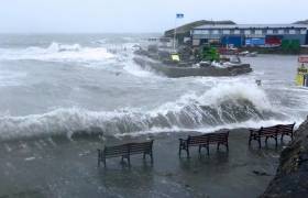
This Sunday 11 December, SCUBA divers dressed in Santa suits will once again dive into the sea water at Bulloch Harbour in Dalkey to raise money for the RNLI, the charity that saves lives at sea.

The annual diving event has raised over €20,000 to date since it was started in 2014 by Karen Kenny of Dublin University Sub Aqua Club.

This year divers will assemble at the harbour at 10am with the first subaquatic Santas entering the water at 11am. Dun Laoghaire RNLI’s D-class lifeboat will also be on site, subject to weather and operations, to support the festive dip.

But anyone can take part wherever they may be, the organisers urge, calling on supporters to jump into the sea, a lake, a river or even your bath, all to raise funds for the RNLI.

All you need to do is wear a Santa hat, Santa suit or even just a Christmas bow and make a donation, no matter how small.

Published in RNLI Lifeboats

A Dun Laoghaire Senator has described this week's €35m Brexit Infrastructure Fund as an 'opportunity' for improvement of crumbling Dublin Bay Harbours.

Senator Barry Ward tweeted that both Coliemore and Bulloch Harbours in Dalkey County Dublin and Dun Laoghaire Harbour were all in need of 'urgent attention' in different ways.

Marine Minister Charlie McConalogue T.D., announced on Monday the new scheme to rejuvenate local authority public piers and harbours throughout coastal communities.

Afloat previously reported in 2020 how the popular Dalkey Island seasonal ferryboat stopped service due to a partial collapse of a cliff-face underneath a footpath leading to the pier at Coliemore Harbour, Co. Dublin

And in 2018, Bulloch Harbour's Bicencentary was against a backdrop of Storm Damage suffered in Storm Emma.

Senator Barry WardSenator Barry Ward

Announcing the scheme, the Minister said this week “This record funding for our coastal communities is an unprecedented opportunity for us to invest in our publicly owned piers and harbours and will shape the future of our coastal communities. Brexit has and will continue to affect our seafood sector in a unique way compared to other industries. I am delighted to be able to offer this level of investment so that we can deliver safe, accessible, lasting infrastructure and support economic diversification right around our coastline.”
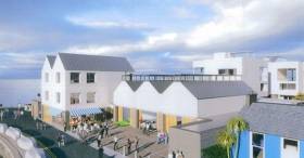
Published in Dublin Bay

A hearing will be held in the High Court writes Dublin Gazette, on an application by local campaigners against a housing development at Bulloch Harbour, Dalkey next week.

Earlier this year, the controversial development got the green light from An Bord Pleanala for three three-storey houses, two apartments, a cafe and a number of other buildings.

There has been anger among some locals, who feel the proposals don’t fit in with the landscape of the surrounding area, and there are also concerns about the potential for flooding.

Save Bulloch Harbour is a campaign led by Bulloch Harbour Preservation Association (BHPA), made up of local boat owners, fishermen, harbour users and residents.

Next Monday, October 14, the high court will hear BHPA’s application for a judicial review of An Bord Planala’s decision to grant planning permission for the proposed development.

For more read here including details of a public meeting to be held by BHPA. 

Published in Dublin Bay

Dublin Gazette writes, that the Bulloch Harbour Preservation Association has announced it has begun fundraising to file for a judicial review of An Bord Pleanala’s (ABP) decision to grant planning permission for a property development on Bulloch Harbour.

Earlier this month ABP granted permission to Bartra Capital Property Group to build three, three storey villas, two apartments as well as number of other buildings such as a café on the iconic south Dublin harbour.

At the time of the decision, Bartra CEO Mike Flannery said this “marks a positive day for Bulloch Harbour and Bartra looks forward to enhancing the environs of Bulloch Harbour on the back of this decision.”

However, local residents who have opposed the development since Bartra originally submitted its proposals have announced they will be attempting to file for a judicial review of the granted planning permission.

In a statement, the association said: “We have been inundated with communications by the members of the public expressing their amazement, disbelief and outrage at the findings of ABP.

For more on this coastal development click here. 

Published in Dublin Bay

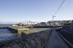
As previously reported on Afloat.ie works to repair Bulloch Harbour in Dalkey along south Dublin Bay is focused on a pier damaged by Storm Emma in March of last year, writes Jehan Ashmore.

According to Bullock Harbour Preservation Association the repairs to the pier's outer north-eastern corner which is exposed to the bay is almost complete. The pier leads off from a quay where a controversial mixed development was recently given the go ahead by An Bord Pleanála at the site of the former Western Marine premises.

The Association which liaises with public bodies and other interested parties to ensure the harbour functions and remains a public asset also provided an update concerning the pier's inner south-western corner.

At this section of the pier which had been subsiding since last summer has now been totally dismantled down to the harbour bottom. It is at this level where new concrete foundations have been laid underwater so that the granite blocks can be reset in their original positions. A completion date for this work is not yet known.

The scenic stone-cut harbour built in 1818/19 by the Ballast Board (now Dublin Port Company) still manages the small working harbour which celebrated its Bicentenary last winter. The small harbour is home to inshore fishing boats engaged in crab and lobster, boat moorings, boat rental operations, the Dalkey Sea Scouts, kayakers, sea anglers and for other marine leisure pursuits.

Access for such activity requires roads in the vicinity of Bulloch Harbour which is the responsiblity of Dun Laoghaire Rathdown County Council. The local authority is currently inviting the public and interested parties to submit obervations and submissions to the Bulloch and Sandycove Harbours Draft Masterplan as previously included. The neighbouring harbour at Sandycove is located further along the coast to the north in Scotsman's Bay.

For further details on the Masterplan click here noting the closing date for submissions is Monday, 19th August.

Published in Dublin Bay

The Irish Times writes of a controversial development proposal for a scenic south Dublin fishing harbour has been given the go ahead by An Bord Pleanála.

Bartra Property, after a protracted planning struggle, has received permission to build a number of housing units at Bulloch Harbour in Dalkey.

It will consist of three three-storey houses, two apartments and a cafe as well as a number of other buildings.

Residents living at and near the picturesque coastal inlet, popular with tourists and for fishing, have long battled the proposals they believe are out of kilter with the surrounding area. Concerns have also been repeatedly aired as to the potential for flooding due to often high sea levels.

Local People Before Profit TD Richard Boyd Barrett said the decision was “incomprehensible”.

“Bulloch Harbour is a unique public amenity used by people of all ages. It is an important part of the heritage of south County Dublin, ” he said.

For more on this coastal development click here. 

Published in Dublin Bay

#lectures - As part of the Bullock Harbour Bicentenary celebrations, the next lecture is to be held on Tuesday (12 March) in the Dalkey Castle and Heritage Centre.

The free lecture programme which began last year has been organised by the Bullock Harbour Preservation Association (BHPA) in conjunction with the Dublin Port Company. So far the lecture themes have concentrated on the history and heritage of Bullock, an attractive small stone cut harbour located near Dalkey town.  

As for the next lecture this will take focus onto the horizon!...  as the talk's title is "The Port across the Bay - evolution from the early 19th century to 2040". The lecture is to be presented by Eamonn O'Reilly, Chief Executive Officer of the Dublin Port Company.

All are welcome to the lecture which will take place at 8pm in the Dalkey Castle & Heritage Centre.

Please be advised that there is now no need to book places as admission is free and the venue is large enough to accommodate all-comers.


Published in Dublin Bay

#lectures - As part of the Bullock 200 Bicentenary, as previously reported on Afloat.ie, the Bullock Harbour Preservation Association and Dublin Port Company resume a series of talks held in the Dalkey Castle and Heritage Centre.

Next week, on Tuesday, 22nd January at 8pm, a talk titled “The Building of Bullock Harbour” will be given by Elizabeth Shotton, Associate Professor at the UCD School of Architecture, Planning & Environmental Policy. Admission is free though places should be booked in advance with the Heritage Centre by emailing: [email protected]

Construction of Bulloch Harbour began in the winter of 1818/1819 by the Ballast Board (now Dublin Port Company) and in relationship to up-keep and maintenance of Bulloch Harbour involves the DPC in initiatives in conjunction with the BHPA and Dalkey Tidy Towns, see related storm damage story. 

Returning to the lectures which began late last year (see below), they will continue up to May 2019 and will focus on the history and heritage of Bullock presented by excellent speakers from the Port Company and elsewhere. The lectures programme as usual will take place at 8pm in the heritage centre.

The first two lectures by Lar Joye, Port Heritage Director, and Rob Goodbody, local historian, were very well received by large audiences in the heritage centre located in Goat's Castle. The castle in Dalkey, is one of only two surviving seven fortified town houses/castles built to store cargo which were off-loaded in Dalkey during the Middle Ages, when Dalkey acted as the port for Dublin between mid-1300s to the late 1500s.

During those times, large Anglo-Norman ships could not access Dublin, as the river Liffey was silted up and navigating was notoriously difficult and dangerous leading to numerous shipwrecks. Instead vessels anchored safely in the deep waters of Dalkey Sound. When the issue of silting on the Liffey was eventually resolved, larger ships could enter Dublin which began with the expansion of the port from the late 1700's.

The Bulloch Harbour lectures have also been supported by the Dalkey Community Council, Dalkey Tidy Towns and the Dalkey Castle & Heritage Centre.

Published in Dublin Bay

#BullochHarbour - A controversial development proposed at Bulloch Harbour, an inlet close to Dalkey in the south Dublin has been refused planning permission.

As The Irish Times writes, Bartra Capital Ltd, founded by developer Richard Barrett, had filed plans last December for seven ground-floor commercial units and six three-storey terraced dwellings at the end of the harbour, as well as a further three houses to the rear of the development.

The plan prompted an immediate reaction from the local community, with a number of public meetings held on the proposals.

Almost 300 formal objections to the development were filed with Dún Laoghaire-Rathdown County Council. 

Planners have now decided to deny permission for the project, saying in a statement that they considered the amount of site area which is reserved for residential use to be excessive.

“Together with the design and layout of the development and the inadequate provision for marine-related uses, [it] seriously compromises the achievement of a quality mixed-use and integrated development, with adequate and appropriate provision for marine and harbour-related activities,” the planners said.

‘Utterly inappropriate’

Local People Before Profit councillor Melisa Halpin welcomed the decision, saying the plans were “utterly inappropriate” for the harbour.

Ms Halpin said it was now time to push for a strategic plan for the harbour which would safeguard it against future, similar proposals.


Published in Dublin Bay

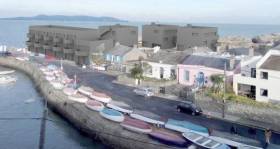
#BullochHarbour - A major campaign in Dalkey is under way to stop what has been described as the ‘Costa del Sol’ style development at Bulloch Harbour in south Dublin.

As The Irish Times writes on the eve of its 200th anniversary, the coastal inlet has been selected by developers as previously reported on Afloat for a commercial and residential scheme that would visually transform a postcard quay popular with fishermen and tourists.

The controversial plans have drawn the ire of local residents, more than 300 of whom crammed into a public meeting at the Fitzpatrick Castle Hotel in Killiney on Thursday to discuss mass opposition.

A 50-minute presentation described a harbour that has existed for hundreds of years and whose modern walls were constructed over just eight months in 1818.

In December, Bartra Capital Ltd, founded by developer Richard Barrett, filed a planning application that would see the replacement of a number of disused sheds with seven ground floor commercial units and six three-storey terraced dwellings,plus a further three houses to the rear.

“This development could be taken from the Costa del Sol. It’s not Irish seaside architecture,” said Susan McDonnell, chair of the Bulloch Harbour Preservation Association (BHPA), outlining the contentious plans.

Those in attendance groaned at a crude computer mock-up depicting dark buildings towering over the existing colourful harbour scene.

For more including slide images of a before and after of the projected development (3-D graphic above) at Dalkey click here.


Published in Dublin Bay
Page 1 of 2

General Information on using Waterways Ireland inland navigations

Safety on the Water

All users of the navigations are strongly recommended to make themselves aware of safety on the water for whatever activity they are involved in and to read the advice offered by the various governing bodies and by:

The Dept. of Transport, Ireland: www.gov.ie/transport and The Maritime and Coastguard Agency, UK, The RNLI – Water Safety Ireland for information in terms of drowning prevention and water safety.

Registration of Vessels

All vessels using the Shannon Navigation, which includes the Shannon-Erne Waterways and the Erne System must be registered with Waterways Ireland. Only open undecked boats with an engine of 15 horsepower or less on the Shannon Navigation, and vessels of 10 horsepower or less on the Erne System, are exempt. Registration is free of charge.

Craft registration should be completed online at: https://www.waterwaysireland.org/online-services/craft-registration

Permits for use of the Grand and Royal Canals and the Barrow Navigation

All vessels using the Grand and Royal Canals and the Barrow Navigation must display appropriate valid Permit(s) i.e A Combined Mooring and Passage Permit (€126) and if not intending to move every five days, an Extended Mooring Permit (€152).

Permit applications should be completed online at: https://www.waterwaysireland.org/online-services/canal-permits

Passage on the Royal and Grand Canals – Dublin Area

For boat passage through the locks east of Lock 12 into / out of Dublin on either the Royal or Grand Canals, Masters are requested to contact the Waterways Ireland Eastern Regional Office (M-F 9.30am-4.30pm) on tel: +353(0)1 868 0148 or email [email protected] prior to making passage in order to plan the necessary lock-keeping assistance arrangements.

On the Grand Canal a minimum of two days notice prior to the planned passage should be given, masters should note that with the exception of pre-arranged events, a maximum of 2 boats per day will be taken through the locks, travelling either east or west.

Movements in or out of the city will be organised by prior arrangement to take place as a single movement in one day. Boaters will be facilitated to travel the system if their passage is considered to be safe by Waterways Ireland and they have the valid permit(s) for mooring and passage.

Newcomen Lifting Bridge

On the Royal Canal two weeks’ notice of bridge passage (Newcomen Lifting Bridge) is required for the pre-set lift date, and lock assistance will then also be arranged. A minimum of 2 boats is required for a bridge lift to go ahead.

Waterways Ireland Eastern Regional Office (Tel: +353(0)1 868 0148 or [email protected] ) is the point of contact for the bridge lift.

A maximum number of boats passing will be implemented to keep to the times given above for the planned lifts (16 for the Sat / Sun lifts & 8 for the weekday lifts). Priority will be given on a first come first served basis.

On day of lift, boaters and passengers must follow guidance from Waterways Ireland staff about sequence of passage under bridge & through Lock 1, and must remain within signed and designated areas.

Events Held on the Waterways

All organised events taking place on the waterways must have the prior approval of Waterways Ireland. This is a twelve week process and application forms must be accompanied with the appropriate insurance, signed indemnity and risk assessment. The application should be completed on the Waterways Ireland events page at :

https://www.waterwaysireland.org/online-services/event-approval

Time Limits on Mooring in Public Harbours

On the Shannon Navigation and the Shannon-Erne Waterway craft may berth in public harbours for five consecutive days or a total of seven days in any one month.

On the Erne System, revised Bye Laws state that: No master or owner shall permit a vessel, boat or any floating or sunken object to remain moored at or in the vicinity of any public mooring, including mooring at any other public mooring within 3 kilometres of that location, for more than 3 consecutive days and shall not moor at that same mooring or any other public mooring within 3 kilometres of that location within the following 3 consecutive days without prior permission by an authorised official.

Winter Mooring on the Shannon Navigation and Shannon Erne Waterway

Winter mooring may be availed of by owners during the period 1 Nov to 31 Mar by prior arrangement and payment of a charge of €63.50 per craft. Craft not availing of Winter Mooring must continue to comply with the “5 Day Rule”. Winter Mooring applications should be completed online at : https://www.waterwaysireland.org/online-services/winter-moorings-booking

Owners should be aware that electricity supply and water supply to public moorings is disconnected for the winter months. This is to protect against frost damage, to reduce running costs and to minimise maintenance requirements during the winter months.

Vessel owners are advised that advance purchasing of electricity on the power bollards leading up to the disconnection date should be minimal. Electricity credit existing on the bollards will not be recoverable after the winter decommissioning date. Both services will be reinstated prior to the commencement of the next boating season.

Smart Cards

Waterways Ireland smart cards are used to operate locks on the Shannon Erne Waterway, to access the service blocks, to use the pump-outs along the navigations, to avail of electrical power at Waterways Ireland jetties.

Berthing in Public Harbours

Masters are reminded of the following:

  • Equip their vessel with mooring lines of appropriate length and strength and only secure their craft to mooring bollards and cleats provided for this purpose.
  • Ensure the available berth is suitable to the length of your vessel, do not overhang the mooring especially on finger moorings on floating pontoon moorings.
  • Ensure mooring lines, electric cables and fresh water hoses do not create a trip hazard on public jetties for others users.
  • Carry sufficient fenders to prevent damage to your own vessel, other vessels and WI property.
  • Allow sufficient space between your vessel and the vessel ahead /astern (c.1m) for fire safety purposes and /or to recover somebody from the water.
  • Do not berth more than two vessels side by side and ensure there is safe access/egress at all times between vessels and onto the harbour itself.
  • Do not berth in such a way to prevent use of harbour safety ladders, slipways or pump-outs.
  • Do not allow the bow of your vessel to overhang the walkway of a floating mooring thus creating a hazard for others with an overhanging anchor or bow fendering.
  • Animals are not allowed to be loose or stray at any time.
  • Harbour and jetty infrastructure such as railings, power pedestals, fresh water taps, electric light poles, safety bollards, ladders etc are not designed for the purpose of mooring craft , they will not bear the strain of a vessel and will be damaged.
  • At Carrybridge on the Erne System, Masters of vessels are not permitted to use stern on mooring. Masters of vessels must use the mooring fingers for mooring of vessels and for embarkation / disembarkation from vessels.

Passenger Vessel Berths

Masters of vessels should not berth on passenger vessel berths where it is indicated that an arrival is imminent. Passenger vessels plying the navigations generally only occupy the berths to embark and disembark passengers and rarely remain on the berths for extended periods or overnight.

Lock Lead-in Jetties

Lead-in jetties adjacent to the upstream and downstream gates at lock chambers are solely for the purpose of craft waiting to use the lock and should not be used for long term berthing.

Vessel Wake

Vessel wake, that is, the wave generated by the passage of the boat through the water, can sometimes be large, powerful and destructive depending on the hull shape and engine power of the vessel. This wake can be detrimental to other users of the navigation when it strikes their craft or inundates the shoreline or riverbank. Masters are requested to frequently look behind and check the effect of their wake / wash particularly when passing moored vessels, on entering harbours and approaching jetties and to be aware of people pursuing other activities such as fishing on the riverbank.

Speed Restriction

A vessel or boat shall not be navigated on the Shannon Navigation at a speed in excess of 5 kph when within 200 metres of a bridge, quay, jetty or wharf, when in a harbour or canal or when passing within 100 metres of a moored vessel or boat.

Vessels navigating the Shannon-Erne Waterway should observe the general 5 kph speed limit which applies along the waterway. This is necessary in order to prevent damage to the banks caused by excessive wash from vessels.

Vessels navigating the Erne System should observe the statutory 5kt / 6mph / 10kph speed limit areas.

A craft on the Royal and Grand canals shall not be navigated at a speed in excess of 6km per hour.

A craft on the Barrow Navigation shall not be navigated at a speed in excess of 11km per hour except as necessary for safe navigation in conditions of fast flow.

Bank Erosion

Narrow sections of all the navigations are particularly prone to bank erosion due to the large wash generated by some craft. Masters are requested to be vigilant and to slow down to a speed sufficient to maintain steerage when they observe the wash of their craft inundating the river banks.

Unusual Waterborne Activity

Unusual waterborne vessels may be encountered from time to time, such as, hovercraft or amphibious aircraft / seaplanes. Masters of such craft are reminded to apply the normal “Rule of the Road” when they meet conventional craft on the water and to allow extra room to manoeuvre in the interest of safety.

Sailing Activity

Mariners will encounter large numbers of sailing dinghies from late June to August in the vicinity of Lough Derg, Lough Ree and Lower Lough Erne. Sailing courses are marked by yellow buoys to suit weather conditions on the day. Vessels should proceed at slow speed and with due caution and observe the rules of navigation when passing these fleets, as many of the participants are junior sailors under training.

Rowing

Mariners should expect to meet canoes and vessels under oars on any part of the navigations, but more so in the vicinity of Athlone, Carrick-on-Shannon, Coleraine, Enniskillen and Limerick. Masters are reminded to proceed at slow speed and especially to reduce their wash to a minimum when passing these craft as they can be easily upset and swamped due to their very low freeboard and always be prepared to give way in any given traffic situation.

Canoeing

Canoeing is an adventure sport and participants are strongly recommended to seek the advice of the sport’s governing bodies i.e Canoeing Ireland and the Canoe Association of Northern Ireland, before venturing onto the navigations.

Persons in charge of canoes are reminded of the inherent danger to these craft associated with operating close to weirs, sluice gates, locks and other infrastructure particularly when rivers are in flood and large volumes of water are moving through the navigations due to general flood conditions or very heavy localised precipitation e.g. turbulent and broken water, stopper waves. Shooting weirs is prohibited without prior permission of Waterways Ireland.

Canoeists should check with lockkeepers prior entering a lock to ensure passage is done in a safe manner. Portage is required at all unmanned locks.

Canoe Trail Network – "Blueways"

Masters of powered craft are reminded that a canoe trail network is being developed across all navigations and to expect more organised canoeing along these trails necessitating slow speed and minimum wash when encountering canoeists, rowing boats etc

Rockingham and Drummans Island Canals – Lough Key

It is expected that work on Rockingham and Drummans Island Canals on Lough Key will be completed in 2021. Access to these canals will be for non-powered craft only, eg canoes, kayaks, rowing boats.

Fast Powerboats and Personal Watercraft (Jet Skis)

Masters of Fast Powerboats (speed greater than 17kts) and Personal Watercraft (i.e.Jet Skis) are reminded of the inherent dangers associated with high speed on the water and especially in the confines of small bays and narrow sections of the navigations. Keeping a proper look-out, making early alterations to course and /or reducing speed will avoid conflict with slower vessels using the navigation. Personal Watercraft are not permitted to be used on the canals.

Towing Waterskiers, Wakeboarders, Doughnuts etc

Masters of vessels engaged in any of these activities are reminded of the manoeuvring constraints imposed upon their vessel by the tow and of the added responsibilities that they have to the person(s) being towed. These activities should be conducted in areas which are clear of conflicting traffic. It is highly recommended that a person additional to the master be carried to act as a “look-out” to keep the tow under observation at all times.

Prohibition on Swimming

Swimming in the navigable channel, particularly at bridges, is dangerous and is prohibited due to the risk of being run over by a vessel underway in the navigation.

Age Restrictions on operating of powered craft

In the Republic of Ireland, Statutory Instrument 921 of 2005 provides the legal requirements regarding the minimum age for operating of powered craft. The Statutory Instrument contains the following requirements:

- The master or owner of a personal watercraft or a fast power craft shall take all reasonable steps to ensure that a person who has not attained the age of 16 years does not operate or control the craft

- The master or owner of a pleasure craft powered by an engine with a rating of more than 5 horse power or 3.7 kilowatts shall take all reasonable steps to ensure that a person who has not attained the age of 12 years does not operate or control the craft.

Lifejackets and Personal Flotation Devices (PFDs)

Lifejackets and PFD’s are the single most important items of personal protective equipment to be used on a vessel and should be worn especially when the vessel is being manoeuvred such as entering / departing a lock, anchoring, coming alongside or departing a jetty or quayside.

In the Republic of Ireland, Statutory Instrument 921 of 2005 provides the legal requirements regarding the wearing of Personal Flotation Devices. The Statutory Instrument contains the following requirements:

- The master or owner of a pleasure craft (other than a personal watercraft) shall ensure, that there are, at all times on board the craft, sufficient suitable personal flotation devices for each person on board.

- A person on a pleasure craft (other than a personal watercraft) of less than 7 metres length overall shall wear a suitable personal flotation device while on board an open craft or while on the deck of decked craft, other than when the craft is made fast to the shore or at anchor.

- The master or owner of a pleasure craft (other than a personal watercraft) shall take all reasonable steps to ensure that a person who has not attained the age of 16 years complies with paragraph above.

- The master or owner of a pleasure craft (other than a personal watercraft), shall take all reasonable steps to ensure that a person who has not attained the age of 16 years wears a suitable personal flotation device while on board an open craft or while on the deck of a decked craft other than when it is made fast to the shore or at anchor.

- The master or owner of a pleasure craft (other than a personal watercraft) shall take all reasonable steps to ensure that a person wears a suitable personal flotation device, at all times while – (a) being towed by the craft, (b) on board a vessel or object of any kind which is being towed by the craft.

Further information is available at: http://www.irishstatutebook.ie/eli/2005/si/921/made/en/print

Firing Range Danger Area – Lough Ree

The attention of mariners is drawn to the Irish Defence Forces Firing Range situated in the vicinity of buoys No’s 2 and 3, on Lough Ree on the Shannon Navigation. This range is used regularly for live firing exercises, throughout the year, all boats and vessels should stay clear of the area marked with yellow buoys showing a yellow "X" topmark and displaying the word "Danger".

Shannon Navigation, Portumna Swing Bridge Tolls

No attempt should be made by Masters’ of vessels to pay the bridge toll while making way through the bridge opening. Payment will only be taken by the Collector from Masters when they are secured alongside the jetties north and south of the bridge.

Navigating from Killaloe to Limerick on the Shannon Navigation

The navigation from Killaloe to Limerick involves passage through Ardnacrusha locks, the associated headrace and tailrace and the Abbey River into Limerick City. Careful passage planning is required to undertake this voyage. Considerations include: lock passage at Ardnacrusha, water flow in the navigation, airdraft under bridges on Abbey River in Limerick, state of tide in Limerick

Users are advised to contact the ESB Ardnacrusha hydroelectric power station (00353 (0)87 9970131) 48 hours in advance of commencing their journey to book passage through the locks at Ardnacrusha. It is NOT advised to undertake a voyage if more than one turbine is operating (20MW), due to the increased velocity of flow in the navigation channel, which can be dangerous. To ascertain automatically in real time how many turbines are running, users can phone +353 (0)87 6477229.

For safety reasons the ESB has advised that only powered craft with a capacity in excess of 5 knots are allowed to enter Ardnacrusha Headrace and Tailrace Canals.

Passage through Sarsfield Lock should be booked on +353-87-7972998, on the day prior to travel and it should be noted also that transit is not possible two hours either side of low water.

A Hydrographic survey in 2020 of the navigation channel revealed that the approach from Shannon Bridge to Sarsfield Lock and the Dock area has silted up. Masters of vessels and water users are advised to navigate to the Lock from Shannon bridge on a rising tide one or two hours before High Tide.

Lower Bann Navigation

The attention of all users is drawn to the “Users Code for the Lower Bann”, in particular to that section covering “Flow in the River” outlining the dangers for users both on the banks and in the navigation, associated with high flow rates when the river is in spate. Canoeists should consult and carry a copy of the “Lower Bann Canoe Trail” guide issued by the Canoe Association of Northern Ireland. Users should also contact the DfI Rivers Coleraine, who is responsible for regulating the flow rates on the river, for advisory information on the flow rates to be expected on any given day.

DfI Rivers Coleraine. Tel: 0044 28 7034 2357 Email: [email protected]

Lower Bann Navigation – Newferry – No wake zone

A No Wake Zone exists on the Lower Bann Navigation at Newferry. Masters of vessels are requested to proceed at a slow speed and create no wake while passing the jetties and slipways at Newferry.

Overhead Power Lines (OHPL) and Air draft

All Masters must be aware of the dangers associated with overhead power lines, in particular sailing vessels and workboats with cranes or large air drafts. Voyage planning is a necessity in order to identify the location of overhead lines crossing the navigation.

Overhead power line heights on the River Shannon are maintained at 12.6metres (40 feet) from Normal Summer level for that section of navigation, masters of vessels with a large air draft should proceed with caution and make additional allowances when water levels are high.

If a vessel or its equipment comes into contact with an OHPL the operator should NOT attempt to move the vessel or equipment. The conductor may still be alive or re-energise automatically. Maintain a safe distance and prevent third parties from approaching due to risk of arcing. Contact the emergency services for assistance.

Anglers are also reminded that a minimum ground distance of 30 metres should be maintained from overhead power lines when using a rod and line.

Submarine Cables and Pipes

Masters of vessels are reminded not to anchor their vessels in the vicinity of submarine cables or pipes in case they foul their anchor or damage the cables or pipes. Look to the river banks for signage indicating their presence.

Water Levels - Precautions

Low Water Levels:

When water levels fall below normal summer levels masters should be aware of:

Navigation

To reduce the risk of grounding masters should navigate on or near the centreline of the channel, avoid short cutting in dog-legged channels and navigating too close to navigation markers.

Proceeding at a slow speed will also reduce “squat” effect i.e. where the vessel tends to sit lower in the water as a consequence of higher speed.

Slipways

Reduced slipway length available under the water surface and the possibility of launching trailers dropping off the end of the concrete apron.

More slipway surface susceptible to weed growth requiring care while engaged in launching boats, from slipping and sliding on the slope. Note also that launching vehicles may not be able to get sufficient traction on the slipway once the craft is launched to get up the incline.

Bank Erosion

Very dry riverbanks are more susceptible to erosion from vessel wash.

Lock Share

Maximising on the number of vessels in a lock will ensure that the total volume of water moving downstream is decreased. Lock cycles should be used for vessels travelling each way.

High Water Levels:

When water levels rise above normal summer level masters should be aware of:

Navigation

Navigation marks will have reduced height above the water level or may disappear underwater altogether making the navigable channel difficult to discern.

In narrow sections of the navigations water levels will tend to rise more quickly than in main streams and air draft at bridges will likewise be reduced.

There will also be increased flow rates particularly in the vicinity of navigation infrastructure such as bridges, weirs, locks etc where extra care in manoeuvring vessels will be required.

Harbours and Jetties

Due care is required in harbours and at slipways when levels are at or near the same level as the harbour walkways' as the edge will be difficult to discern especially in reduced light conditions. It is advised that Personal Flotation Devices be worn if tending to craft in a harbour in these conditions.

Slipways

Slipways should only be used for the purpose of launching and recovering of water craft or other objects from the water. Before using a slipway it should be examined to ensure that the surface has sufficient traction/grip for the intended purpose such as launching a craft from a trailer using a vehicle, that there is sufficient depth of water on the slipway to float the craft off the trailer before the concrete apron ends and that the wheels of the trailer do not drop off the edge of the slipway. That life-saving appliances are available in the vicinity, that the vehicle is roadworthy and capable of coping with the weight of the trailer and boat on the incline. It is recommended that slipway operations are conducted by two persons.

Caution to be Used in Reliance upon Aids to Navigation

The aids to navigation depicted on the navigation guides comprise a system of fixed and floating aids to navigation. Prudent mariners will not rely solely on any single aid to navigation, particularly a floating aid to navigation. With respect to buoys, the buoy symbol is used to indicate the approximate position of the buoy body and the ground tackle which secures it to the lake or river bed. The approximate position is used because of the practical limitations in positioning and maintaining buoys in precise geographical locations. These limitations include, but are not limited to, prevailing atmospheric and lake/river conditions, the slope of and the material making up the lake/river bed, the fact that the buoys are moored to varying lengths of chain, and the fact that the buoy body and/or ground tackle positions are not under continuous surveillance. Due to the forces of nature, the position of the buoy body can be expected to shift inside and outside the charted symbol.

Buoys and perches are also moved out of position or pulled over by those mariners who use them to moor up to instead of anchoring. To this end, mariners should always monitor their passage by relating buoy/perch positions with the published navigation guide. Furthermore, a vessel attempting to pass close by always risks collision with a yawing buoy or with the obstruction that the buoy or beacon/perch marks.

Masters of Vessels are requested to use the most up to date Navigation guides when navigating on the Inland Waterways.

Information taken from Special Marine Notice No 1 of 2023