Menu

Ireland's sailing, boating & maritime magazine

Inland afloat headers


Displaying items by tag: Cruise ships

Within hours of each other two ultra-luxurious vessels departed Dublin Port this morning, firstly the five star-rated cruiseship Hebridean Princess, and then followed the Bikini registered Cary Ali, a private charter mini-motoryacht, writes Jehan Ashmore.
Hebridean Princess, a former 600-passenger car-ferry, converted to carry only 50 guests, reached Carlingford around noon, where she is at anchor off the Co. Louth listed medieval heritage town. On the far side of Ulster, the cross-border waterway on Lough Foyle received two of three scheduled cruise-calls, but bad weather prevented Prisendem from anchoring off Greencastle in July.

As for Cary Ali, she is a 87ft long was built in 2007 by Nordhavn to a design of Jeff Leishman. From her stern flew the flag of the Marshal Islands in the Pacific Ocean. Inside the four-decked vessel there is the main salon, a dining room, galley and three guest staterooms, and a master cabin (click HERE). In total eight people can be accommodated. In addition she has a jacuzzi, fly-bridge and is equipped with a tender and has crew of four.

She has a speed of 24-knots and is equipped with 50hp bow and stern thrusters. To read more about the luxurious motoryacht including facts and figures click HERE.

The Cary Ali had berthed at the 100-berth marina of the Poolbeg Yacht & Boat Club which caters lesiure craft up to 20 metres and is centrally located on the south side of Dublin Port. The facility has accommodated larger motoryachts over the years. Though even larger motoryachts such as Battered Bull, a Feadship 52m has berthed further upriver at Dublin City Moorings.

Published in Cruise Liners
During the weekend call of L.E. Eithne to Galway Harbour, the Naval Service flagship shared the mid-west port with a Spanish oceanographic research vessel (RV) and a cargoship,writes Jehan Ashmore.
The port consists of a single basin named the Dún Aengus Dock where the Vigo registered RV Vizconde de Eza (2000/1,401grt) was berthed. The 53m vessel is run by the 'Secrataria General del Mer' (MARM) which is on an assignment to asses the abundance, estimation and distribution patterns of demersal-benthic species in the Porcupine Abyssal Plain. The port is of also the homeport to the Marine Institute RV vessels and their headquarters based in nearby Oranmore.

Also sharing the basin but located closer to the dock gates was Arklow Shipping Ltd's Dutch registered dry-cargo vessel Arklow Surf (2000/2,316grt). The dock is capable of handling more vessels simultaneously and of course used as a host-port of the high-profile Volvo Ocean Race which is due to return next year.

Galway and neighbouring Limerick City with its Ted Russell Dock, are the only dock-gate accessed ports on the island of Ireland. In the case of Galway there is an exception as freight operations are also available from an outer pier on the seaward side of Dún Aengus Dock though only for domestic purposes. From this pier the dedicated Aran Islands freight service is operated by Lasta Mara TEO's Blath na Mara (1983/330grt). As for Limerick, vessels can also berth outside the dock but they tend to be small port-work related craft that use the outer berth on the Shannon Estuary.

The Galway Harbour Company in recent years have proposed plans for a new outer port, to be built in four stages with a completion date set for 2017. This would enable larger deeper drafted vessels such as tankers and cruiseships to dock in the new port. In the meantime cruiseships anchor off Mutton Island. In addition a freight rail-link, berthing for an inshore fishing fleet and a 216 berth marina are proposed.

To read more about the port proposals visit http://www.galwayharbour.com/news.php?id=11and for aerial visual impressions click HERE.

Published in Galway Harbour
With today's historic Irish rugby victory over Australia, fans of the green jersey, who happen to be on a cruise-ship with Cunard Line or P&O Cruises, will be able to continue watching games of the Rugby World Cup, writes Jehan Ashmore.
One of the ten participating cruise ships, Cunard Line's Queen Elizabeth (90,901 gross tonnes) owned by Carnival Corporation, made her maiden 'Irish' call to Dublin Port and Cobh last week, is showing live or recorded games within 24 hours from the original kick-off. This will enable games to be shown at convenient times for the participating cruise ships in their various locations.

A total of 24 matches are being shown, starting from the opening game and will include all four Home Nations' matches, quarter-finals, semi -finals, bronze final and then the final on 23rd October. Of course there will be other fans on board from Wales, Scotland, England and elsewhere watching the fixtures throughout the cruise-ships various sporting bars, pubs and other venues.

Carnival Corporation's UK entertainment services general manager, Paul Wright, said: "The Rugby World Cup is of great interest to many of our passengers and we're pleased that nobody will miss out by being on holiday with us throughout this time. At any one time we could have more than 19,000 passengers collectively on board and rooting for one of the Four Nations to bring home the trophy".

He added: "Most people have a sport that they follow and some times, like on a cruise ship, you won't have access to your favourite sport, which means a lot to fans. On our last cruise on Independence of the Seas, we had popular sports shown in state rooms and certain bars around the ship, of course football was the most common sport shown".

Incidentally Independence of the Seas has also called to Cobh since her Irish debut in 2007 and at 154,407 tonnes is the largest ever cruise-caller to Cork Harbour. She surpasses Cunard Line's flagship Queen Mary 2 of 148,528 tonnes which too berthed at Cobh last Wednesday, four days after Queen Elizabeth's inaugural visit.

Published in Cruise Liners
At 13.07hrs Stena Line's HSS 1500 fast-craft ferry HSS Stena Explorer pulled away from her berth for the last time this year on the Dun Laoghaire Harbour-Holyhead route, as she headed for the harbour mouth several crew members waved from the stern to shore-based colleagues on the link-span, writes Jehan Ashmore.
Only yesterday, sailings on the daily single-round trip operated route had to be cancelled due to adverse weather conditions on the Irish Sea caused by the tail end of Hurricane Katia. The decision with today's closure was made well in advance and comes as no surprise as the Stena Explorer (1996/19,638grt) "has traded at a financial loss for several years" according to her owners Stena Line. Around 53 staff in Dun Laoghaire will be affected by the decision.

The core reason to withdraw the HSS on the 120-minute route which is not to re-open until the 2012 season, rests with the high operating costs of the fuel-thirsty fast-ferry which is powered by four gas-turbine engines. In addition the route's generated most of its turnover during the period May-September, leaving the remaining months unsustainable, as such the company wants the route to be seasonal-only in the long-term.

HSS_Stena_Explorer

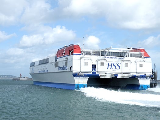
HSS Stena Explorer departs Dun Laoghaire Harbour on her final sailing this season. Photo: Jehan Ashmore

Passengers and freight customers will instead need to use the company's other Dublin Bay route between Dublin Port and Holyhead. The 3 hour 15-minute central corridor route is served by two ro-pax vessels, Stena Adventurer (2004/43,532 grt) and Stena Nordica (2000/24,206 grt) which operate to a year-round schedule, for times click HERE.

What is not certain is the precise date for resumption of Dun Laoghaire-Holyhead services as Stena Line have only indicated that they hope to reopen in April or May nor it is outlined as to what type of fast-craft would operate the route next year.

With today's break in service for at least the next six months, this is the most significant absence of the revolutionary HSS (High Speed Sea Service) 1500 fast-ferry which made her official maiden voyage on the route from Dun Laoghaire on 10th April 1996. The only other notable occasions when the HSS was off-service was for the short spells to allow for annual dry-docking, refit, repairs or when the route in recent years was partially operated by Stena Lynx III.

The 1500 referred to the number of passengers the Stena Explorer could accommodate. She was the first of the three Finish-built HSS 1500 catamaran vehicle capable carrying craft to enter service on three routes from the UK. The next sister completed HSS Stena Discovery entered service in the same year between Harwich-Hook van Holland and the final of the trio HSS Stena Voyager entered the Belfast-Stranraer route in 1997. Several years ago the HSS ceased operating on the Dutch route and the HSS currently serving on the North Channel is due to be replaced by conventional ferries in mid-November as previously reported on Afloat.ie, to read more click HERE.

On the Dun Laoghaire-Holyhead service the HSS enjoyed the boom years, and at its peak there were five daily round trips. From 2006 onwards the routes fortunes began to decline due to the ending of duty-free sales, competition from low-cost airlines, and the increasing cost of fuel.

In order to stave off further losses, a series of cost cutting measures were implemented over the next five years. Firstly the sailing frequency was reduced then the passage times were increased to reduce fuel consumption at the expense of faster crossings. In addition the company resorted to withdrawing the Stena Explorer during the shoulder months surrounding the summer and as previously mentioned these sailings were covered by the Stena Lynx III.

When the Stena Explorer returned for the summer months, the Stena Lynx III switched to her normal high-season spell on Rosslare-Fishguard sailings in tandem with regular route vessel Stena Europe. This year she served as usual on the St. Georges Channel route with the last high-season sailing completed on 4 September.

Stena Lynx III remained initially at Fishguard until making a repositioning voyage to Dun Laoghaire via the Kish Lighthouse last Wednesday. She berthed adjacent to the now disused HSS berth link-span on St. Michaels Wharf. The Tasmanian built craft has spent previous winter layover periods in Dublin and last year in Dun Laoghaire whereas the Stena Explorer is expected to do so in her home port of Holyhead.

At the neighbouring Carlisle Pier, the former terminal where numerous steam-packets, 'mailboats' and the conventional Sealink/British Rail car-ferries served (the last being the Stena Adventurer better known as St. Columba built in 1977) there are plans for a national diaspora museum.

The centrepiece landmark building would form as part of the masterplan proposed by the Dun Laoghaire Harbour Company as part of a concerted effort to offset the reduced role of ferry operations. The masterplan is also to attract cruiseship business amongst other proposals envisaged.

Published in Ferry
Jewel of the Seas, one of four 90,000 tonnes Radiance Class cruise ships operated by Royal Caribbean Cruise Lines (RCCL) departed Dublin Port this evening bound for Cork Harbour, writes Jehan Ashmore.
During the cruisecall of the near 300 metre-long vessel, she took on bunkers from the 70m short-sea coastal tanker Keewhit (2,332dwt) which arrived from Liverpool this morning. The procedure to transfer fuel is relatively commonplace particularly with larger cruiseships calling the capital. To see photo of Keewhit transferring fuel in a similar operation which took place when the Grand Princess visited Dublin earlier this year, click HERE.

The 2,500 passenger Jewel of the Seas has a nine-deck centrum which has glass lifts which allows light to flow throughout the spacious and airy ship. Activities range from golf to climbing, a spa and sumptuous restaurants.

When the 2004 built cruiseship docks at the dedicated cruise berth at Cobh in the early hours of tomorrow she will also be sharing the deepwater berth with the 2001 built Silver Whisper. The ultra-luxury vessel accommodates only 388 passengers and is operated by SilverSeas Cruises. To read more about the vessel click HERE.

Both vessels are scheduled to depart Cobh around teatime tomorrow and this will be followed by preparations of the picturesque town which is to welcome the maiden call to Cobh of Queen Elizabeth on Saturday. To read more about the newest vessel of the Cunard Line fleet click HERE. The 2010 built vessel will firstly make an inaugural call to Dublin on Friday prior to the Cobh call which coincides with Cork Harbour Open Day, for event details visit www.corkharbour.ie

Published in Cruise Liners
With less than a fortnight to go Corkonians and visitors alike can look forward to Cork Harbour Open Day, writes Jehan Ashmore
The Cork Harbour event is take place on Saturday 10 September, and on that morning the newest vessel of the Cunard Line fleet, the Queen Elizabeth is to make her maiden call to Cork following a visit to Dublin. At over 90,000 tonnes, the cruiseship which was named last year by Queen Elizabeth is to dock at Cobh. Visitors will be able to view the impressive vessel from the quayside. To read more facts and figures about the Cunard Line vessel click HERE.

This will be the third Cork Harbour Day which is to cover a wide range of events, such as concerts on Spike Island, a photographic exhibition in Camden Fort, guided tours of an Irish naval ship at Cork City Quays and an open day at the National Maritime College of Ireland (NMCI).

In addition Fastnet Line's ferry Julia will be open for the public to board. The 22,161 gross tonnes serves the Cork-Swansea route and for the Open Day she will be berthed at Ringaskiddy Deepwater Berth instead of the nearby ferry terminal. To read details of Open day programme visit www.corkharbour.ie and updates click HERE.

The concept for the Harbour Open Day emerged three years ago, which combined various stakeholders involved in the development and implementation of the Integrated Strategy for Cork Harbour. A group comprising of representatives from UCC, City and County Councils, the Naval Service and the Port of Cork set about working together to engage with users of the harbour and to organise the Open Day.

Cork Harbour is the second largest natural harbour in the world, next to Sydney Harbour, offering beautiful locations for enjoying the outdoors, dramatic coastlines, and excellent leisure facilities, and is home to some very talented artists, sportsmen and women, and people who are passionate about the history, heritage and cultural value of Cork Harbour.

Published in Cork Harbour
Following the historic visit of Queen Elizabeth to Ireland in May, Cunard Line's newest cruiseship Queen Elizabeth is to make her maiden 'Irish' voyage next month, writes Jehan Ashmore.
In a ceremony held in her home port of Southampton the 2,038 guest capacity /1,100 crew cruiseship was named by Queen Elizabeth in October last year. To watch the naming ceremony click the video.

The 90,901 gross registered tonnes cruise ship is to depart her Hampshire homeport, where she is to similarly follow the monarch in that she is scheduled to make a port of call to Dublin first on 9 September and make a call to Cork afterwards.

With a length of 295m / 965-feet the vessel will dock in the centre of the capital port before she sails overnight to make a morning arrival at Cobh, the dedicated cruise terminal for the Port of Cork. She is scheduled to stay at the Cork Harbour town formerly named Queenstown until a 17.00 hour departure.

Her visit coincides with Cork Harbour Open Day, where visitors can view the impressive vessel from the quayside, for more details visit www.corkharbour.ie

Incidentally her near-sister Queen Victoria also called to Dublin in May and the remaining vessel of the Cunard fleet, the 'flagship' liner Queen Mary 2 is also to dock in Cobh three days later after Queen Elisabeth's visit.

Published in Cruise Liners
Prior to the start of this evening's 'Western Europe Cruise' from Dublin Port of the Azamara Journey, existing cruiseship passengers are exploring the visitor attractions of Trinity College and Powerscourt Gardens in Co. Wicklow, writes Jehan Ashmore.
The 30,000 tonnes Azamara Jouney (photo) arrived early this morning from a cruise that had set off from Copenhagen on a Norwegian Fjords and Iceland Cruise. Some of the passengers of the 700-capacity vessel ended their cruise in Dublin today by flying home. As passengers left others arrived mostly from Europe and the United States had flown in to pick up the cruise from Dublin. In addition Irish passengers are boarding the ship which is operated by Azamara Club Cruises.

Tonight's departure is for Holyhead, where the call to Anglesey also covers tours of Snowdonia, the impressive castles of Conwy, Caernarvon and Harlech and a stop to Bodnant. Following the Welsh call she is to visit Cobh. Other calls are to Bordeaux (overnight), Bibao, Gijon,Vigo and the final port of call is Lisbon on 7 September where passengers will remain in their cabins for an overnight stay. The next day there is a scheduled tour of the Gulbenkian Museum, the Jeronimos Monastery and Sintra.

On one-day the ship will spend the entire day at sea which will enable passengers to indulge further of the facilities such as the casino and entertainment in the theatre, for more click HERE. Fares for the Irish passengers of the 10-day cruise/11-day holiday started at €2,062 per person (cruise-only) based on the lowest grade twin cabin. After completion of the cruise in Lisbon they will take a flight to return to Dublin.

Azamara Journey formed part of the eight-strong series commissioned for Renaissance Cruises which collapsed a decade ago. They were built by Chantiers de l'Atlantique in St.Nazaire and were uninspiringly named as R One, R Two etc with the R Six now the re-named Azamara Journey.

As August and the high-season draws to a close that doesn't' stop the cruiseships calling as over twenty more are due in Dublin before the season closes. In total the port this year has handled some 90 cruiseships and 160,000 passengers. A further 65 callers so far are scheduled for 2012.

Published in Cruise Liners
12th August 2011

Big Lips Kiss Dublin Bay

A cruise ship with a difference docked in Dublin Port today, the Aidablu displays a distinctly bold livery scheme of a giant red mouth and eyes emblazoned across the bow, writes Jehan Ashmore.
Towering 15 decks above the oceans, the Italian built 71,300 tonnes vessel berthed at Ocean Pier after an overnight passage from Cobh. Aidablu has a capacity for over 2,000 passengers and 600 crew.The vessel has all the usual expected facilites to be found on a cruiseship but she also has a rather novel attraction, a brewery, the first to be installed on a cruise ship.

She was launched last year from the Meyer Werft shipyard. The 252 m vessel is operated by German operator Aida Cruises and the lips symbol is also the logo used by the company which operates a fleet of seven vessels.

Should you wish to take a closer look of Aidablu, she departs this evening at 21.00hrs and she will head out of Dublin Bay via the North Burford buoy off the Baily Lighthouse bound for Liverpool. The cruise started from Dover and after her visit to Merseyside tommorrow, she will then proceed to Greenock, followed by Invergorden before ending the cruise in Hamburg.  

Published in Cruise Liners
Ireland's leading fishing port of Killybegs, Co. Donegal, this morning received the 226 passenger yacht-like cruiseship Le Diamant, writes Jehan Ashmore.
The 8,282 tonnes Le Diamant had sailed overnight from anchorage in Galway Bay and prior to visiting the 'City of the Tribes' the vessel also called to Foynes port in the Shannon Estuary as reported previously in Afloat.

In 2004 Killybegs received a significant boost in the completion of a €50m outer harbour with berthing quays totalling 350-metres long so to accommodate the north-west fleet and to include the 'supertrawlers'.

Despite the major port infrastructural investment, Killybegs has seen declining fortunes in the fish industry though in recent year's new business from the offshore exploration and cruise ship industries has assisted in generating new revenue.

Published in Cruise Liners
Page 2 of 3

General Information on using Waterways Ireland inland navigations

Safety on the Water

All users of the navigations are strongly recommended to make themselves aware of safety on the water for whatever activity they are involved in and to read the advice offered by the various governing bodies and by:

The Dept. of Transport, Ireland: www.gov.ie/transport and The Maritime and Coastguard Agency, UK, The RNLI – Water Safety Ireland for information in terms of drowning prevention and water safety.

Registration of Vessels

All vessels using the Shannon Navigation, which includes the Shannon-Erne Waterways and the Erne System must be registered with Waterways Ireland. Only open undecked boats with an engine of 15 horsepower or less on the Shannon Navigation, and vessels of 10 horsepower or less on the Erne System, are exempt. Registration is free of charge.

Craft registration should be completed online at: https://www.waterwaysireland.org/online-services/craft-registration

Permits for use of the Grand and Royal Canals and the Barrow Navigation

All vessels using the Grand and Royal Canals and the Barrow Navigation must display appropriate valid Permit(s) i.e A Combined Mooring and Passage Permit (€126) and if not intending to move every five days, an Extended Mooring Permit (€152).

Permit applications should be completed online at: https://www.waterwaysireland.org/online-services/canal-permits

Passage on the Royal and Grand Canals – Dublin Area

For boat passage through the locks east of Lock 12 into / out of Dublin on either the Royal or Grand Canals, Masters are requested to contact the Waterways Ireland Eastern Regional Office (M-F 9.30am-4.30pm) on tel: +353(0)1 868 0148 or email [email protected] prior to making passage in order to plan the necessary lock-keeping assistance arrangements.

On the Grand Canal a minimum of two days notice prior to the planned passage should be given, masters should note that with the exception of pre-arranged events, a maximum of 2 boats per day will be taken through the locks, travelling either east or west.

Movements in or out of the city will be organised by prior arrangement to take place as a single movement in one day. Boaters will be facilitated to travel the system if their passage is considered to be safe by Waterways Ireland and they have the valid permit(s) for mooring and passage.

Newcomen Lifting Bridge

On the Royal Canal two weeks’ notice of bridge passage (Newcomen Lifting Bridge) is required for the pre-set lift date, and lock assistance will then also be arranged. A minimum of 2 boats is required for a bridge lift to go ahead.

Waterways Ireland Eastern Regional Office (Tel: +353(0)1 868 0148 or [email protected] ) is the point of contact for the bridge lift.

A maximum number of boats passing will be implemented to keep to the times given above for the planned lifts (16 for the Sat / Sun lifts & 8 for the weekday lifts). Priority will be given on a first come first served basis.

On day of lift, boaters and passengers must follow guidance from Waterways Ireland staff about sequence of passage under bridge & through Lock 1, and must remain within signed and designated areas.

Events Held on the Waterways

All organised events taking place on the waterways must have the prior approval of Waterways Ireland. This is a twelve week process and application forms must be accompanied with the appropriate insurance, signed indemnity and risk assessment. The application should be completed on the Waterways Ireland events page at :

https://www.waterwaysireland.org/online-services/event-approval

Time Limits on Mooring in Public Harbours

On the Shannon Navigation and the Shannon-Erne Waterway craft may berth in public harbours for five consecutive days or a total of seven days in any one month.

On the Erne System, revised Bye Laws state that: No master or owner shall permit a vessel, boat or any floating or sunken object to remain moored at or in the vicinity of any public mooring, including mooring at any other public mooring within 3 kilometres of that location, for more than 3 consecutive days and shall not moor at that same mooring or any other public mooring within 3 kilometres of that location within the following 3 consecutive days without prior permission by an authorised official.

Winter Mooring on the Shannon Navigation and Shannon Erne Waterway

Winter mooring may be availed of by owners during the period 1 Nov to 31 Mar by prior arrangement and payment of a charge of €63.50 per craft. Craft not availing of Winter Mooring must continue to comply with the “5 Day Rule”. Winter Mooring applications should be completed online at : https://www.waterwaysireland.org/online-services/winter-moorings-booking

Owners should be aware that electricity supply and water supply to public moorings is disconnected for the winter months. This is to protect against frost damage, to reduce running costs and to minimise maintenance requirements during the winter months.

Vessel owners are advised that advance purchasing of electricity on the power bollards leading up to the disconnection date should be minimal. Electricity credit existing on the bollards will not be recoverable after the winter decommissioning date. Both services will be reinstated prior to the commencement of the next boating season.

Smart Cards

Waterways Ireland smart cards are used to operate locks on the Shannon Erne Waterway, to access the service blocks, to use the pump-outs along the navigations, to avail of electrical power at Waterways Ireland jetties.

Berthing in Public Harbours

Masters are reminded of the following:

  • Equip their vessel with mooring lines of appropriate length and strength and only secure their craft to mooring bollards and cleats provided for this purpose.
  • Ensure the available berth is suitable to the length of your vessel, do not overhang the mooring especially on finger moorings on floating pontoon moorings.
  • Ensure mooring lines, electric cables and fresh water hoses do not create a trip hazard on public jetties for others users.
  • Carry sufficient fenders to prevent damage to your own vessel, other vessels and WI property.
  • Allow sufficient space between your vessel and the vessel ahead /astern (c.1m) for fire safety purposes and /or to recover somebody from the water.
  • Do not berth more than two vessels side by side and ensure there is safe access/egress at all times between vessels and onto the harbour itself.
  • Do not berth in such a way to prevent use of harbour safety ladders, slipways or pump-outs.
  • Do not allow the bow of your vessel to overhang the walkway of a floating mooring thus creating a hazard for others with an overhanging anchor or bow fendering.
  • Animals are not allowed to be loose or stray at any time.
  • Harbour and jetty infrastructure such as railings, power pedestals, fresh water taps, electric light poles, safety bollards, ladders etc are not designed for the purpose of mooring craft , they will not bear the strain of a vessel and will be damaged.
  • At Carrybridge on the Erne System, Masters of vessels are not permitted to use stern on mooring. Masters of vessels must use the mooring fingers for mooring of vessels and for embarkation / disembarkation from vessels.

Passenger Vessel Berths

Masters of vessels should not berth on passenger vessel berths where it is indicated that an arrival is imminent. Passenger vessels plying the navigations generally only occupy the berths to embark and disembark passengers and rarely remain on the berths for extended periods or overnight.

Lock Lead-in Jetties

Lead-in jetties adjacent to the upstream and downstream gates at lock chambers are solely for the purpose of craft waiting to use the lock and should not be used for long term berthing.

Vessel Wake

Vessel wake, that is, the wave generated by the passage of the boat through the water, can sometimes be large, powerful and destructive depending on the hull shape and engine power of the vessel. This wake can be detrimental to other users of the navigation when it strikes their craft or inundates the shoreline or riverbank. Masters are requested to frequently look behind and check the effect of their wake / wash particularly when passing moored vessels, on entering harbours and approaching jetties and to be aware of people pursuing other activities such as fishing on the riverbank.

Speed Restriction

A vessel or boat shall not be navigated on the Shannon Navigation at a speed in excess of 5 kph when within 200 metres of a bridge, quay, jetty or wharf, when in a harbour or canal or when passing within 100 metres of a moored vessel or boat.

Vessels navigating the Shannon-Erne Waterway should observe the general 5 kph speed limit which applies along the waterway. This is necessary in order to prevent damage to the banks caused by excessive wash from vessels.

Vessels navigating the Erne System should observe the statutory 5kt / 6mph / 10kph speed limit areas.

A craft on the Royal and Grand canals shall not be navigated at a speed in excess of 6km per hour.

A craft on the Barrow Navigation shall not be navigated at a speed in excess of 11km per hour except as necessary for safe navigation in conditions of fast flow.

Bank Erosion

Narrow sections of all the navigations are particularly prone to bank erosion due to the large wash generated by some craft. Masters are requested to be vigilant and to slow down to a speed sufficient to maintain steerage when they observe the wash of their craft inundating the river banks.

Unusual Waterborne Activity

Unusual waterborne vessels may be encountered from time to time, such as, hovercraft or amphibious aircraft / seaplanes. Masters of such craft are reminded to apply the normal “Rule of the Road” when they meet conventional craft on the water and to allow extra room to manoeuvre in the interest of safety.

Sailing Activity

Mariners will encounter large numbers of sailing dinghies from late June to August in the vicinity of Lough Derg, Lough Ree and Lower Lough Erne. Sailing courses are marked by yellow buoys to suit weather conditions on the day. Vessels should proceed at slow speed and with due caution and observe the rules of navigation when passing these fleets, as many of the participants are junior sailors under training.

Rowing

Mariners should expect to meet canoes and vessels under oars on any part of the navigations, but more so in the vicinity of Athlone, Carrick-on-Shannon, Coleraine, Enniskillen and Limerick. Masters are reminded to proceed at slow speed and especially to reduce their wash to a minimum when passing these craft as they can be easily upset and swamped due to their very low freeboard and always be prepared to give way in any given traffic situation.

Canoeing

Canoeing is an adventure sport and participants are strongly recommended to seek the advice of the sport’s governing bodies i.e Canoeing Ireland and the Canoe Association of Northern Ireland, before venturing onto the navigations.

Persons in charge of canoes are reminded of the inherent danger to these craft associated with operating close to weirs, sluice gates, locks and other infrastructure particularly when rivers are in flood and large volumes of water are moving through the navigations due to general flood conditions or very heavy localised precipitation e.g. turbulent and broken water, stopper waves. Shooting weirs is prohibited without prior permission of Waterways Ireland.

Canoeists should check with lockkeepers prior entering a lock to ensure passage is done in a safe manner. Portage is required at all unmanned locks.

Canoe Trail Network – "Blueways"

Masters of powered craft are reminded that a canoe trail network is being developed across all navigations and to expect more organised canoeing along these trails necessitating slow speed and minimum wash when encountering canoeists, rowing boats etc

Rockingham and Drummans Island Canals – Lough Key

It is expected that work on Rockingham and Drummans Island Canals on Lough Key will be completed in 2021. Access to these canals will be for non-powered craft only, eg canoes, kayaks, rowing boats.

Fast Powerboats and Personal Watercraft (Jet Skis)

Masters of Fast Powerboats (speed greater than 17kts) and Personal Watercraft (i.e.Jet Skis) are reminded of the inherent dangers associated with high speed on the water and especially in the confines of small bays and narrow sections of the navigations. Keeping a proper look-out, making early alterations to course and /or reducing speed will avoid conflict with slower vessels using the navigation. Personal Watercraft are not permitted to be used on the canals.

Towing Waterskiers, Wakeboarders, Doughnuts etc

Masters of vessels engaged in any of these activities are reminded of the manoeuvring constraints imposed upon their vessel by the tow and of the added responsibilities that they have to the person(s) being towed. These activities should be conducted in areas which are clear of conflicting traffic. It is highly recommended that a person additional to the master be carried to act as a “look-out” to keep the tow under observation at all times.

Prohibition on Swimming

Swimming in the navigable channel, particularly at bridges, is dangerous and is prohibited due to the risk of being run over by a vessel underway in the navigation.

Age Restrictions on operating of powered craft

In the Republic of Ireland, Statutory Instrument 921 of 2005 provides the legal requirements regarding the minimum age for operating of powered craft. The Statutory Instrument contains the following requirements:

- The master or owner of a personal watercraft or a fast power craft shall take all reasonable steps to ensure that a person who has not attained the age of 16 years does not operate or control the craft

- The master or owner of a pleasure craft powered by an engine with a rating of more than 5 horse power or 3.7 kilowatts shall take all reasonable steps to ensure that a person who has not attained the age of 12 years does not operate or control the craft.

Lifejackets and Personal Flotation Devices (PFDs)

Lifejackets and PFD’s are the single most important items of personal protective equipment to be used on a vessel and should be worn especially when the vessel is being manoeuvred such as entering / departing a lock, anchoring, coming alongside or departing a jetty or quayside.

In the Republic of Ireland, Statutory Instrument 921 of 2005 provides the legal requirements regarding the wearing of Personal Flotation Devices. The Statutory Instrument contains the following requirements:

- The master or owner of a pleasure craft (other than a personal watercraft) shall ensure, that there are, at all times on board the craft, sufficient suitable personal flotation devices for each person on board.

- A person on a pleasure craft (other than a personal watercraft) of less than 7 metres length overall shall wear a suitable personal flotation device while on board an open craft or while on the deck of decked craft, other than when the craft is made fast to the shore or at anchor.

- The master or owner of a pleasure craft (other than a personal watercraft) shall take all reasonable steps to ensure that a person who has not attained the age of 16 years complies with paragraph above.

- The master or owner of a pleasure craft (other than a personal watercraft), shall take all reasonable steps to ensure that a person who has not attained the age of 16 years wears a suitable personal flotation device while on board an open craft or while on the deck of a decked craft other than when it is made fast to the shore or at anchor.

- The master or owner of a pleasure craft (other than a personal watercraft) shall take all reasonable steps to ensure that a person wears a suitable personal flotation device, at all times while – (a) being towed by the craft, (b) on board a vessel or object of any kind which is being towed by the craft.

Further information is available at: http://www.irishstatutebook.ie/eli/2005/si/921/made/en/print

Firing Range Danger Area – Lough Ree

The attention of mariners is drawn to the Irish Defence Forces Firing Range situated in the vicinity of buoys No’s 2 and 3, on Lough Ree on the Shannon Navigation. This range is used regularly for live firing exercises, throughout the year, all boats and vessels should stay clear of the area marked with yellow buoys showing a yellow "X" topmark and displaying the word "Danger".

Shannon Navigation, Portumna Swing Bridge Tolls

No attempt should be made by Masters’ of vessels to pay the bridge toll while making way through the bridge opening. Payment will only be taken by the Collector from Masters when they are secured alongside the jetties north and south of the bridge.

Navigating from Killaloe to Limerick on the Shannon Navigation

The navigation from Killaloe to Limerick involves passage through Ardnacrusha locks, the associated headrace and tailrace and the Abbey River into Limerick City. Careful passage planning is required to undertake this voyage. Considerations include: lock passage at Ardnacrusha, water flow in the navigation, airdraft under bridges on Abbey River in Limerick, state of tide in Limerick

Users are advised to contact the ESB Ardnacrusha hydroelectric power station (00353 (0)87 9970131) 48 hours in advance of commencing their journey to book passage through the locks at Ardnacrusha. It is NOT advised to undertake a voyage if more than one turbine is operating (20MW), due to the increased velocity of flow in the navigation channel, which can be dangerous. To ascertain automatically in real time how many turbines are running, users can phone +353 (0)87 6477229.

For safety reasons the ESB has advised that only powered craft with a capacity in excess of 5 knots are allowed to enter Ardnacrusha Headrace and Tailrace Canals.

Passage through Sarsfield Lock should be booked on +353-87-7972998, on the day prior to travel and it should be noted also that transit is not possible two hours either side of low water.

A Hydrographic survey in 2020 of the navigation channel revealed that the approach from Shannon Bridge to Sarsfield Lock and the Dock area has silted up. Masters of vessels and water users are advised to navigate to the Lock from Shannon bridge on a rising tide one or two hours before High Tide.

Lower Bann Navigation

The attention of all users is drawn to the “Users Code for the Lower Bann”, in particular to that section covering “Flow in the River” outlining the dangers for users both on the banks and in the navigation, associated with high flow rates when the river is in spate. Canoeists should consult and carry a copy of the “Lower Bann Canoe Trail” guide issued by the Canoe Association of Northern Ireland. Users should also contact the DfI Rivers Coleraine, who is responsible for regulating the flow rates on the river, for advisory information on the flow rates to be expected on any given day.

DfI Rivers Coleraine. Tel: 0044 28 7034 2357 Email: [email protected]

Lower Bann Navigation – Newferry – No wake zone

A No Wake Zone exists on the Lower Bann Navigation at Newferry. Masters of vessels are requested to proceed at a slow speed and create no wake while passing the jetties and slipways at Newferry.

Overhead Power Lines (OHPL) and Air draft

All Masters must be aware of the dangers associated with overhead power lines, in particular sailing vessels and workboats with cranes or large air drafts. Voyage planning is a necessity in order to identify the location of overhead lines crossing the navigation.

Overhead power line heights on the River Shannon are maintained at 12.6metres (40 feet) from Normal Summer level for that section of navigation, masters of vessels with a large air draft should proceed with caution and make additional allowances when water levels are high.

If a vessel or its equipment comes into contact with an OHPL the operator should NOT attempt to move the vessel or equipment. The conductor may still be alive or re-energise automatically. Maintain a safe distance and prevent third parties from approaching due to risk of arcing. Contact the emergency services for assistance.

Anglers are also reminded that a minimum ground distance of 30 metres should be maintained from overhead power lines when using a rod and line.

Submarine Cables and Pipes

Masters of vessels are reminded not to anchor their vessels in the vicinity of submarine cables or pipes in case they foul their anchor or damage the cables or pipes. Look to the river banks for signage indicating their presence.

Water Levels - Precautions

Low Water Levels:

When water levels fall below normal summer levels masters should be aware of:

Navigation

To reduce the risk of grounding masters should navigate on or near the centreline of the channel, avoid short cutting in dog-legged channels and navigating too close to navigation markers.

Proceeding at a slow speed will also reduce “squat” effect i.e. where the vessel tends to sit lower in the water as a consequence of higher speed.

Slipways

Reduced slipway length available under the water surface and the possibility of launching trailers dropping off the end of the concrete apron.

More slipway surface susceptible to weed growth requiring care while engaged in launching boats, from slipping and sliding on the slope. Note also that launching vehicles may not be able to get sufficient traction on the slipway once the craft is launched to get up the incline.

Bank Erosion

Very dry riverbanks are more susceptible to erosion from vessel wash.

Lock Share

Maximising on the number of vessels in a lock will ensure that the total volume of water moving downstream is decreased. Lock cycles should be used for vessels travelling each way.

High Water Levels:

When water levels rise above normal summer level masters should be aware of:

Navigation

Navigation marks will have reduced height above the water level or may disappear underwater altogether making the navigable channel difficult to discern.

In narrow sections of the navigations water levels will tend to rise more quickly than in main streams and air draft at bridges will likewise be reduced.

There will also be increased flow rates particularly in the vicinity of navigation infrastructure such as bridges, weirs, locks etc where extra care in manoeuvring vessels will be required.

Harbours and Jetties

Due care is required in harbours and at slipways when levels are at or near the same level as the harbour walkways' as the edge will be difficult to discern especially in reduced light conditions. It is advised that Personal Flotation Devices be worn if tending to craft in a harbour in these conditions.

Slipways

Slipways should only be used for the purpose of launching and recovering of water craft or other objects from the water. Before using a slipway it should be examined to ensure that the surface has sufficient traction/grip for the intended purpose such as launching a craft from a trailer using a vehicle, that there is sufficient depth of water on the slipway to float the craft off the trailer before the concrete apron ends and that the wheels of the trailer do not drop off the edge of the slipway. That life-saving appliances are available in the vicinity, that the vehicle is roadworthy and capable of coping with the weight of the trailer and boat on the incline. It is recommended that slipway operations are conducted by two persons.

Caution to be Used in Reliance upon Aids to Navigation

The aids to navigation depicted on the navigation guides comprise a system of fixed and floating aids to navigation. Prudent mariners will not rely solely on any single aid to navigation, particularly a floating aid to navigation. With respect to buoys, the buoy symbol is used to indicate the approximate position of the buoy body and the ground tackle which secures it to the lake or river bed. The approximate position is used because of the practical limitations in positioning and maintaining buoys in precise geographical locations. These limitations include, but are not limited to, prevailing atmospheric and lake/river conditions, the slope of and the material making up the lake/river bed, the fact that the buoys are moored to varying lengths of chain, and the fact that the buoy body and/or ground tackle positions are not under continuous surveillance. Due to the forces of nature, the position of the buoy body can be expected to shift inside and outside the charted symbol.

Buoys and perches are also moved out of position or pulled over by those mariners who use them to moor up to instead of anchoring. To this end, mariners should always monitor their passage by relating buoy/perch positions with the published navigation guide. Furthermore, a vessel attempting to pass close by always risks collision with a yawing buoy or with the obstruction that the buoy or beacon/perch marks.

Masters of Vessels are requested to use the most up to date Navigation guides when navigating on the Inland Waterways.

Information taken from Special Marine Notice No 1 of 2023