Menu

Ireland's sailing, boating & maritime magazine

Inland afloat headers


Displaying items by tag: Dalkey Island

Ringsend residents lined the streets of the south Dublin village to pay respects to the late Ken Cunningham following his funeral Mass on Saturday (3 February).

For many years Ken ran the passenger ferry, Licence No 1877, from Coliemore Harbour to Dalkey Island and made such an impact on the local community that Coliemore became affectionately known as “Ken’s Harbour”.

Ken was also an accomplished rower — unsurprising as he was one of the storied Cunninghams of Dalkey and East Coast rowing renown — and was a member of both Dalkey Rowing Club and St Patrick’s Rowing Club in Ringsend, which was his home in later years and where he leaves a lasting legacy.

Among those paying tribute on social media were Dakley Tidy Towns, who described Ken as “fund of knowledge and information on our surrounding waters”.

Members of St Patrick’s Rowing Club form a guard of honour outside St Patrick’s Church in Ringsend at the funeral Mass for Ken Cunningham on Saturday 3 FebruaryMembers of St Patrick’s Rowing Club form a guard of honour outside St Patrick’s Church in Ringsend at the funeral Mass for Ken Cunningham on Saturday 3 February

Published in Dublin Bay

Size for size, Dalkey, aka Deilginis, must be the most story-covered island in all of Ireland. The ancient Irish monks were here. The Vikings were here. Thanks to Napoleon and Cape Mortella, it has its own Martello
Tower. A dinghy cruise-in-company to the island in 1887 played an important role in establishing the Dublin Bay Water Wag Class.

And today, it is the magic Treasure Island, a rite of seagoing passage for young people learning to sail in Dun Laoghaire. Peadar Curran has Dalkey Island as a lifelong interest. He tells all with the DBOGA in Poolbeg Y&BC this Thursday night (November 16th), and you can support the lifeboats while you're at it.

Published in Dublin Bay Old Gaffers
Tagged under

Dun Laoghaire-Rathdown County Council is currently carrying out a visitor survey for Dalkey Island to assist in the long-term management and protection of a key historical and ecological site in Dublin Bay.

Dalkey Island, which is owned by the council, is a part of the Dublin Bay Biosphere, and is home to a significant colony roseate terns, not to mention seals, rabbits and wild goats.

The island has also been an important site of pilgrimage for many centuries, and was previously knows as St Begnet’s Isle.

The online survey aims to quantify the number of visitors and the quality of their experience. It will only take a few minutes to complete, and is available HERE.

Published in Dublin Bay

Thefts of outboard motors and break-ins to boats on moorings were prevalent a couple of years ago. My own boat suffered nearly €6,000 of damage and theft when it was broken into on the mooring at Crosshaven in Cork Harbour during that spate of robberies. An alert, dedicated Garda detective in Cobh on the other side of Cork Harbour recovered some of the items when he located the culprits.

"This week three outboard motors were recovered in Kinsale"

This week three outboard motors were recovered in Kinsale thanks to a member of the public who spotted two men acting suspiciously near the water’s edge at Scilly. They fled, leaving behind a dinghy with three outboard engines in it. Gardai, called to the scene, discovered that attempts had been made to remove engines from two other boats in the harbour area.

"Garda advice is to lock-up your equipment"

That has led to a timely reminder from Gardai who observed that the boating season seems to be starting earlier ever year, urging owners to protect their equipment. Some owners told me after my boat was broken into, that they leave their hatches unlocked on moorings to avoid any break-in damage, but I wonder what about equipment aboard cruisers? The Garda advice is to lock-up and mark your electronic and other equipment. Use your Eircode or some other marking that cannot be removed and take a photograph of the equipment and its marking.

Good advice….and that was one of three stories which stand out for me this week ….. The name change forced on the organisation which has done great work in water safety is another and then there is the battle on Dalkey Island off South County Dublin.

Forcing a Change at Irish Water

John Leech, a well-known and experienced race officer and sailor, who is also Commodore of Lough Derg Yacht Club, is Chief Executive of Irish Water Safety and very devoted to the protection of life in the water…. He told me this week that his organisation is changing its name and that is all because of Irish Water.

Water safety IrelandWater Safety Ireland's new logo

“Since ‘Irish Water’ was established in 2013, it has caused Irish Water Safety considerable difficulty. Some members of the public get confused and believe we are “Irish Water. We can take up to 15 or 20 phone calls a day from angry and frustrated members of the public who have water supply problems. As a result of this confusion, we requested to our partner Department, Rural and Community Affairs that our name be changed to ‘Water Safety Ireland’.”

• Listen to John Leech on the Podcast below as he explains this.

The Battle on Dalkey Island

So, onto Dalkey Island where BirdWatch Ireland and the Royal Society for the Protection of Birds, are currently baiting rats under the EU-funded Roseate Tern LIFE Programme to protect seabirds. It’s not the only island on the East Coast which has a problem with rats and funding to remove them hasn’t been easily made available.

Dalkey Island and Sorrento Terrace viewed from Dalkey Hill
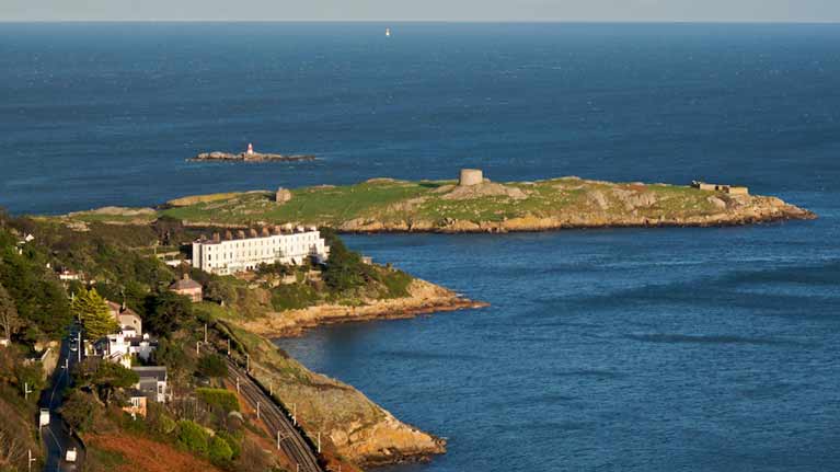
Dalkey Island viewed from Killiney Hill Photo: Wikipedia

“If we can keep this island and its satellites rat-free, then other burrow-nesting and crevice-nesting species could potentially settle there,” Dr. Stephen Newton, Senior Seabird Conservation Officer at BirdWatch Ireland, told me on my radio programme, THIS ISLAND NATION and added:” Who knows, we might even one day have Puffins nesting on Dalkey Island?” Non-toxic bait and ‘flavoured treats’ in combination with trail cameras will also be used to ascertain whether the rates have been got rid of.

• The Podcast below has more details of the brown rat menace to inshore islands on the East Coast.

Published in Tom MacSweeney

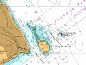
#MarineNotice - Mariners are advised that a Port Lateral Mark has been deployed marking Leac Buidhe Rock, north of Dalkey Island.

The buoy has the following light characteristic Fl(4)R.6s, and will be seasonally deployed from April to October. It can be found at position 53°16.650’N 006°05.100’W.

Afloat.ie understands that the mark placement has been made at the suggestion of Dublin Bay Sailing Club, after a number of incidents in which boats have been damaged by contact with Leac Buidhe Rock.

In 2015, Winter DBSC Turkey Shoot organiser Fintan Cairns issued a warning to competitors to look out for the rock that had caused problems for competitors. See the warning to competitors and a  photo of Leac Buidhe here.

While welcoming the new buoy, Cairns also says 'unfortunately it will only be marked for summer months so we will have to be careful during winter'.
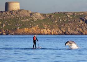
 

Published in Dublin Bay

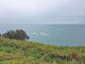
#Rescue - Two divers were rescued yesterday afternoon (Sunday 20 August) after they failed to surface during a dive off Dalkey Island.

The dive boat cox alerted the Irish Coast Guard by marine VHF and began a search patter procedure as Dun Laoghaire Coast Guard’s four search units, Dun Laoghaire RNLI’s all-weather lifeboat and the coastguard helicopter Rescue 116 were all tasked to the scene.

The lifeboat and helicopter backed up the dive boat and coastguard search of the coast from Coliemore Harbour to Killiney Beach, a distance of some 15km.

Within minutes, coastguard members searching off Whiterock spotted the divers being pushed towards the coast with the tide and wind as weather conditions worsened.

All vessels were alerted, and the dive boat recovered the two divers, who were said to be in good spirits despite their ordeal.

In a second callout yesterday, Dun Laoghaire Coast Guard volunteers were tasked to assist a 17ft boat with engine failure being towed to Dun Laoghaire Harbour by lifeboat. All aboard were reported in good condition.

Published in Rescue

#DalkeyIslandSlipOpens – Dalkey Island's newly constructed slipway harbour was officially opened today by An Cathaoirleach of Dún Laoghaire-Rathdown County Council, Cllr Carrie Smyth, writes Jehan Ashmore.

Speaking at the launch at Coliemore Harbour, An Cathaoirleach said: "I am delighted to be able to officially open the new slipway on Dalkey Island in what are my last few days as Cathaoirleach. Dalkey Island is a truly beautiful and important part of our county and I congratulate all of those who contributed to this project."

As previously reported on Afloat.ie, the works of the slipway landing stage were carried out by Richard Nolan Civic Engineering and took almost a month to complete.

The upgrade which cost €350,000 was part of a PART 8 Programme which was implemented following a study undertaken in January 2010 that identified that the existing slipway on the island had fallen into a state of disrepair, restricting access at low tides.

According to Declan Nolan of the contractors, some of the work days involved extended 18 hours due to access delays caused by the vagaries of the sea.

During the main construction stage, this necessitated use of a self-propelled pontoon barge, the Kesmit that transported heavy plant machinery weighing more than 20 tonnes and building supplies that were loaded at Dun Laoghaire Harbour.

The new slipway is stepped at various heights for the tidal range and is overall higher than that of the previous structure. A widened channel and dredging has created easier and safer access for boats to berth.

Most importantly, the public can once again safely visit Dalkey Island which is designated as one of 16 parks within Dun Laoghaire-Rathdown County Council.

Dalkey Island's strategic location between Dublin and Co. Wicklow provides an experience that is a unique place with significant seascapes of both Dublin and Killiney bays. In addition the 20-acre island's importance is varied in terms of ecological, archaeological, architectural and cultural heritage.

As for tourism potential, a new combined visitor ticket to the Dalkey Castle & Heritage Centre and passage to the island by a licensed commercial ferryboat will be made available for the first time.

There has not been a ferryboat service for three years, though the reinstatement of such service is expected to return within the next fortnight.The delay is due to the final stages of the new slipway where safety features to improve boarding and disembarkation is currently underway.

Equally similar works at Coliemore Harbour are also in progress to address and improve safer and easier access for boarding and disembarkation.

It is understood that Tim Carey, Heritage Officer of the DLRCoCo who launched the Dalkey Islands Conservation Plan: 2014-2024 along with Cllr Carrie Smyth earlier this week, has already granted a permit for the ferryboat which too has been certified with a license from the Department of Transport.

Only when such safety feature works are completed on both the island and the mainland that the commercial ferryboat service will resume. The boat is licensed to take five passengers on each of the 4-minute hop crossings to the island.


Published in Island News

A popular south Dublin boating spot is set to be back on the Dublin Bay boating map again this Summer thanks to Dun Laoghaire Rathdown County council  (DLRCoCo) plans to install a new landing jetty on Dalkey Island.

The proposal to upgrade the island's slipway and pier will allow boats to bring people to the island for the first time in almost two years.

There is still access to the island but possible only by small tender to a rough jetty. Most  boating visitors merely anchor off and enjoy the island's quiet anchorage, wildlife and the magnificent views of the surrounding Dublin and Killiney bays.

The works will involve the slipway being slabbed to make for safer surface. Steps will also be provided to enable easier movement from the slip to the pier deck; the construction of which is currently very poor. Access steps on the island will also be widened and previously placed mooring rings and handrails, which have corroded, are to be replaced.
The positioning of a handrail along the northern side of the slip, pier and steps, will also make it easier and safer for people to go about their business, as will a galvanised ladder and a steel pole at the seawards end of the slipway which will act as a navigation aid, DLRCoCo say.

The island is only a short sail of less than 30 minutes from nearby Dun Laoghaire Harbour and its town marina. Over 1,000 pleasure craft berthed there could visit the heritage site if facilties were improved.

Dun Laoghaire-Rathdown County Council has decided that the pier should be completely replaced with a new raised concrete structure, new steps constructed and handrails added.

Published in Island News
Tagged under

#MissingSwimmerRTÉ News is reporting that a swimmer taken from the water after going missing off Dalkey Island in Dublin Bay this morning (Sunday 7 April) has died.

Earlier this evening The Irish Times reported that the 35-year-old man was in a critical condition in Tallaght Hospital after being recovered from the water off Sorrento Terrace.

Lifeboat volunteers with Dun Laoghaire RNLI and the Irish Coast Guard's Dublin-based helicopter Rescue 116 were involved in the search which began around 11am today after the swimmer failed to return to shore.

Published in News Update

#dbsc – Dublin Bay sailors Paul Keane and Hugh Sheehy have announced plans for a unique sailing event in Ireland this coming sailing season.

The Island Trial, an open sailing time trial on a fixed course in Dublin Bay was first announced on Sunday 23rd March to the local dinghy sailors who had gathered to collect prizes and wind up the 42nd Dun Laoghaire frostbite season.

The 11km fixed course utilises famous local landmarks and Dublin Bay racing marks which are laid on the bay from Mid April to October each year.

What makes the event truly unique is that to enter sailors must provide a GPX tracking file which verifies the course sailed and the start and finish times. This means the course is open every day (and night) and sailors can decide when they would like to have a go.

At the moment there are two prizes up for grabs. First is the Bragging Rights Cup for the outright record which is being eyed up by the local moth and skiff fleet, although some big boats may have a chance too.

Then there's the Handy Sailor Silver Salver - the trophy for the winner on corrected time - which highlights the skill of the crew, no matter what their boat. Other prizes such as a junior trophy will be added as the event progresses.

The event has piqued the curiosity of many and several sailors visiting Dun Laoghaire for the biennial 4 day regatta in July will have a go at the trial. All boat types are welcome, from foiling moths to MOD-70s.

Published in DBSC
Tagged under
Page 1 of 4

General Information on using Waterways Ireland inland navigations

Safety on the Water

All users of the navigations are strongly recommended to make themselves aware of safety on the water for whatever activity they are involved in and to read the advice offered by the various governing bodies and by:

The Dept. of Transport, Ireland: www.gov.ie/transport and The Maritime and Coastguard Agency, UK, The RNLI – Water Safety Ireland for information in terms of drowning prevention and water safety.

Registration of Vessels

All vessels using the Shannon Navigation, which includes the Shannon-Erne Waterways and the Erne System must be registered with Waterways Ireland. Only open undecked boats with an engine of 15 horsepower or less on the Shannon Navigation, and vessels of 10 horsepower or less on the Erne System, are exempt. Registration is free of charge.

Craft registration should be completed online at: https://www.waterwaysireland.org/online-services/craft-registration

Permits for use of the Grand and Royal Canals and the Barrow Navigation

All vessels using the Grand and Royal Canals and the Barrow Navigation must display appropriate valid Permit(s) i.e A Combined Mooring and Passage Permit (€126) and if not intending to move every five days, an Extended Mooring Permit (€152).

Permit applications should be completed online at: https://www.waterwaysireland.org/online-services/canal-permits

Passage on the Royal and Grand Canals – Dublin Area

For boat passage through the locks east of Lock 12 into / out of Dublin on either the Royal or Grand Canals, Masters are requested to contact the Waterways Ireland Eastern Regional Office (M-F 9.30am-4.30pm) on tel: +353(0)1 868 0148 or email [email protected] prior to making passage in order to plan the necessary lock-keeping assistance arrangements.

On the Grand Canal a minimum of two days notice prior to the planned passage should be given, masters should note that with the exception of pre-arranged events, a maximum of 2 boats per day will be taken through the locks, travelling either east or west.

Movements in or out of the city will be organised by prior arrangement to take place as a single movement in one day. Boaters will be facilitated to travel the system if their passage is considered to be safe by Waterways Ireland and they have the valid permit(s) for mooring and passage.

Newcomen Lifting Bridge

On the Royal Canal two weeks’ notice of bridge passage (Newcomen Lifting Bridge) is required for the pre-set lift date, and lock assistance will then also be arranged. A minimum of 2 boats is required for a bridge lift to go ahead.

Waterways Ireland Eastern Regional Office (Tel: +353(0)1 868 0148 or [email protected] ) is the point of contact for the bridge lift.

A maximum number of boats passing will be implemented to keep to the times given above for the planned lifts (16 for the Sat / Sun lifts & 8 for the weekday lifts). Priority will be given on a first come first served basis.

On day of lift, boaters and passengers must follow guidance from Waterways Ireland staff about sequence of passage under bridge & through Lock 1, and must remain within signed and designated areas.

Events Held on the Waterways

All organised events taking place on the waterways must have the prior approval of Waterways Ireland. This is a twelve week process and application forms must be accompanied with the appropriate insurance, signed indemnity and risk assessment. The application should be completed on the Waterways Ireland events page at :

https://www.waterwaysireland.org/online-services/event-approval

Time Limits on Mooring in Public Harbours

On the Shannon Navigation and the Shannon-Erne Waterway craft may berth in public harbours for five consecutive days or a total of seven days in any one month.

On the Erne System, revised Bye Laws state that: No master or owner shall permit a vessel, boat or any floating or sunken object to remain moored at or in the vicinity of any public mooring, including mooring at any other public mooring within 3 kilometres of that location, for more than 3 consecutive days and shall not moor at that same mooring or any other public mooring within 3 kilometres of that location within the following 3 consecutive days without prior permission by an authorised official.

Winter Mooring on the Shannon Navigation and Shannon Erne Waterway

Winter mooring may be availed of by owners during the period 1 Nov to 31 Mar by prior arrangement and payment of a charge of €63.50 per craft. Craft not availing of Winter Mooring must continue to comply with the “5 Day Rule”. Winter Mooring applications should be completed online at : https://www.waterwaysireland.org/online-services/winter-moorings-booking

Owners should be aware that electricity supply and water supply to public moorings is disconnected for the winter months. This is to protect against frost damage, to reduce running costs and to minimise maintenance requirements during the winter months.

Vessel owners are advised that advance purchasing of electricity on the power bollards leading up to the disconnection date should be minimal. Electricity credit existing on the bollards will not be recoverable after the winter decommissioning date. Both services will be reinstated prior to the commencement of the next boating season.

Smart Cards

Waterways Ireland smart cards are used to operate locks on the Shannon Erne Waterway, to access the service blocks, to use the pump-outs along the navigations, to avail of electrical power at Waterways Ireland jetties.

Berthing in Public Harbours

Masters are reminded of the following:

  • Equip their vessel with mooring lines of appropriate length and strength and only secure their craft to mooring bollards and cleats provided for this purpose.
  • Ensure the available berth is suitable to the length of your vessel, do not overhang the mooring especially on finger moorings on floating pontoon moorings.
  • Ensure mooring lines, electric cables and fresh water hoses do not create a trip hazard on public jetties for others users.
  • Carry sufficient fenders to prevent damage to your own vessel, other vessels and WI property.
  • Allow sufficient space between your vessel and the vessel ahead /astern (c.1m) for fire safety purposes and /or to recover somebody from the water.
  • Do not berth more than two vessels side by side and ensure there is safe access/egress at all times between vessels and onto the harbour itself.
  • Do not berth in such a way to prevent use of harbour safety ladders, slipways or pump-outs.
  • Do not allow the bow of your vessel to overhang the walkway of a floating mooring thus creating a hazard for others with an overhanging anchor or bow fendering.
  • Animals are not allowed to be loose or stray at any time.
  • Harbour and jetty infrastructure such as railings, power pedestals, fresh water taps, electric light poles, safety bollards, ladders etc are not designed for the purpose of mooring craft , they will not bear the strain of a vessel and will be damaged.
  • At Carrybridge on the Erne System, Masters of vessels are not permitted to use stern on mooring. Masters of vessels must use the mooring fingers for mooring of vessels and for embarkation / disembarkation from vessels.

Passenger Vessel Berths

Masters of vessels should not berth on passenger vessel berths where it is indicated that an arrival is imminent. Passenger vessels plying the navigations generally only occupy the berths to embark and disembark passengers and rarely remain on the berths for extended periods or overnight.

Lock Lead-in Jetties

Lead-in jetties adjacent to the upstream and downstream gates at lock chambers are solely for the purpose of craft waiting to use the lock and should not be used for long term berthing.

Vessel Wake

Vessel wake, that is, the wave generated by the passage of the boat through the water, can sometimes be large, powerful and destructive depending on the hull shape and engine power of the vessel. This wake can be detrimental to other users of the navigation when it strikes their craft or inundates the shoreline or riverbank. Masters are requested to frequently look behind and check the effect of their wake / wash particularly when passing moored vessels, on entering harbours and approaching jetties and to be aware of people pursuing other activities such as fishing on the riverbank.

Speed Restriction

A vessel or boat shall not be navigated on the Shannon Navigation at a speed in excess of 5 kph when within 200 metres of a bridge, quay, jetty or wharf, when in a harbour or canal or when passing within 100 metres of a moored vessel or boat.

Vessels navigating the Shannon-Erne Waterway should observe the general 5 kph speed limit which applies along the waterway. This is necessary in order to prevent damage to the banks caused by excessive wash from vessels.

Vessels navigating the Erne System should observe the statutory 5kt / 6mph / 10kph speed limit areas.

A craft on the Royal and Grand canals shall not be navigated at a speed in excess of 6km per hour.

A craft on the Barrow Navigation shall not be navigated at a speed in excess of 11km per hour except as necessary for safe navigation in conditions of fast flow.

Bank Erosion

Narrow sections of all the navigations are particularly prone to bank erosion due to the large wash generated by some craft. Masters are requested to be vigilant and to slow down to a speed sufficient to maintain steerage when they observe the wash of their craft inundating the river banks.

Unusual Waterborne Activity

Unusual waterborne vessels may be encountered from time to time, such as, hovercraft or amphibious aircraft / seaplanes. Masters of such craft are reminded to apply the normal “Rule of the Road” when they meet conventional craft on the water and to allow extra room to manoeuvre in the interest of safety.

Sailing Activity

Mariners will encounter large numbers of sailing dinghies from late June to August in the vicinity of Lough Derg, Lough Ree and Lower Lough Erne. Sailing courses are marked by yellow buoys to suit weather conditions on the day. Vessels should proceed at slow speed and with due caution and observe the rules of navigation when passing these fleets, as many of the participants are junior sailors under training.

Rowing

Mariners should expect to meet canoes and vessels under oars on any part of the navigations, but more so in the vicinity of Athlone, Carrick-on-Shannon, Coleraine, Enniskillen and Limerick. Masters are reminded to proceed at slow speed and especially to reduce their wash to a minimum when passing these craft as they can be easily upset and swamped due to their very low freeboard and always be prepared to give way in any given traffic situation.

Canoeing

Canoeing is an adventure sport and participants are strongly recommended to seek the advice of the sport’s governing bodies i.e Canoeing Ireland and the Canoe Association of Northern Ireland, before venturing onto the navigations.

Persons in charge of canoes are reminded of the inherent danger to these craft associated with operating close to weirs, sluice gates, locks and other infrastructure particularly when rivers are in flood and large volumes of water are moving through the navigations due to general flood conditions or very heavy localised precipitation e.g. turbulent and broken water, stopper waves. Shooting weirs is prohibited without prior permission of Waterways Ireland.

Canoeists should check with lockkeepers prior entering a lock to ensure passage is done in a safe manner. Portage is required at all unmanned locks.

Canoe Trail Network – "Blueways"

Masters of powered craft are reminded that a canoe trail network is being developed across all navigations and to expect more organised canoeing along these trails necessitating slow speed and minimum wash when encountering canoeists, rowing boats etc

Rockingham and Drummans Island Canals – Lough Key

It is expected that work on Rockingham and Drummans Island Canals on Lough Key will be completed in 2021. Access to these canals will be for non-powered craft only, eg canoes, kayaks, rowing boats.

Fast Powerboats and Personal Watercraft (Jet Skis)

Masters of Fast Powerboats (speed greater than 17kts) and Personal Watercraft (i.e.Jet Skis) are reminded of the inherent dangers associated with high speed on the water and especially in the confines of small bays and narrow sections of the navigations. Keeping a proper look-out, making early alterations to course and /or reducing speed will avoid conflict with slower vessels using the navigation. Personal Watercraft are not permitted to be used on the canals.

Towing Waterskiers, Wakeboarders, Doughnuts etc

Masters of vessels engaged in any of these activities are reminded of the manoeuvring constraints imposed upon their vessel by the tow and of the added responsibilities that they have to the person(s) being towed. These activities should be conducted in areas which are clear of conflicting traffic. It is highly recommended that a person additional to the master be carried to act as a “look-out” to keep the tow under observation at all times.

Prohibition on Swimming

Swimming in the navigable channel, particularly at bridges, is dangerous and is prohibited due to the risk of being run over by a vessel underway in the navigation.

Age Restrictions on operating of powered craft

In the Republic of Ireland, Statutory Instrument 921 of 2005 provides the legal requirements regarding the minimum age for operating of powered craft. The Statutory Instrument contains the following requirements:

- The master or owner of a personal watercraft or a fast power craft shall take all reasonable steps to ensure that a person who has not attained the age of 16 years does not operate or control the craft

- The master or owner of a pleasure craft powered by an engine with a rating of more than 5 horse power or 3.7 kilowatts shall take all reasonable steps to ensure that a person who has not attained the age of 12 years does not operate or control the craft.

Lifejackets and Personal Flotation Devices (PFDs)

Lifejackets and PFD’s are the single most important items of personal protective equipment to be used on a vessel and should be worn especially when the vessel is being manoeuvred such as entering / departing a lock, anchoring, coming alongside or departing a jetty or quayside.

In the Republic of Ireland, Statutory Instrument 921 of 2005 provides the legal requirements regarding the wearing of Personal Flotation Devices. The Statutory Instrument contains the following requirements:

- The master or owner of a pleasure craft (other than a personal watercraft) shall ensure, that there are, at all times on board the craft, sufficient suitable personal flotation devices for each person on board.

- A person on a pleasure craft (other than a personal watercraft) of less than 7 metres length overall shall wear a suitable personal flotation device while on board an open craft or while on the deck of decked craft, other than when the craft is made fast to the shore or at anchor.

- The master or owner of a pleasure craft (other than a personal watercraft) shall take all reasonable steps to ensure that a person who has not attained the age of 16 years complies with paragraph above.

- The master or owner of a pleasure craft (other than a personal watercraft), shall take all reasonable steps to ensure that a person who has not attained the age of 16 years wears a suitable personal flotation device while on board an open craft or while on the deck of a decked craft other than when it is made fast to the shore or at anchor.

- The master or owner of a pleasure craft (other than a personal watercraft) shall take all reasonable steps to ensure that a person wears a suitable personal flotation device, at all times while – (a) being towed by the craft, (b) on board a vessel or object of any kind which is being towed by the craft.

Further information is available at: http://www.irishstatutebook.ie/eli/2005/si/921/made/en/print

Firing Range Danger Area – Lough Ree

The attention of mariners is drawn to the Irish Defence Forces Firing Range situated in the vicinity of buoys No’s 2 and 3, on Lough Ree on the Shannon Navigation. This range is used regularly for live firing exercises, throughout the year, all boats and vessels should stay clear of the area marked with yellow buoys showing a yellow "X" topmark and displaying the word "Danger".

Shannon Navigation, Portumna Swing Bridge Tolls

No attempt should be made by Masters’ of vessels to pay the bridge toll while making way through the bridge opening. Payment will only be taken by the Collector from Masters when they are secured alongside the jetties north and south of the bridge.

Navigating from Killaloe to Limerick on the Shannon Navigation

The navigation from Killaloe to Limerick involves passage through Ardnacrusha locks, the associated headrace and tailrace and the Abbey River into Limerick City. Careful passage planning is required to undertake this voyage. Considerations include: lock passage at Ardnacrusha, water flow in the navigation, airdraft under bridges on Abbey River in Limerick, state of tide in Limerick

Users are advised to contact the ESB Ardnacrusha hydroelectric power station (00353 (0)87 9970131) 48 hours in advance of commencing their journey to book passage through the locks at Ardnacrusha. It is NOT advised to undertake a voyage if more than one turbine is operating (20MW), due to the increased velocity of flow in the navigation channel, which can be dangerous. To ascertain automatically in real time how many turbines are running, users can phone +353 (0)87 6477229.

For safety reasons the ESB has advised that only powered craft with a capacity in excess of 5 knots are allowed to enter Ardnacrusha Headrace and Tailrace Canals.

Passage through Sarsfield Lock should be booked on +353-87-7972998, on the day prior to travel and it should be noted also that transit is not possible two hours either side of low water.

A Hydrographic survey in 2020 of the navigation channel revealed that the approach from Shannon Bridge to Sarsfield Lock and the Dock area has silted up. Masters of vessels and water users are advised to navigate to the Lock from Shannon bridge on a rising tide one or two hours before High Tide.

Lower Bann Navigation

The attention of all users is drawn to the “Users Code for the Lower Bann”, in particular to that section covering “Flow in the River” outlining the dangers for users both on the banks and in the navigation, associated with high flow rates when the river is in spate. Canoeists should consult and carry a copy of the “Lower Bann Canoe Trail” guide issued by the Canoe Association of Northern Ireland. Users should also contact the DfI Rivers Coleraine, who is responsible for regulating the flow rates on the river, for advisory information on the flow rates to be expected on any given day.

DfI Rivers Coleraine. Tel: 0044 28 7034 2357 Email: [email protected]

Lower Bann Navigation – Newferry – No wake zone

A No Wake Zone exists on the Lower Bann Navigation at Newferry. Masters of vessels are requested to proceed at a slow speed and create no wake while passing the jetties and slipways at Newferry.

Overhead Power Lines (OHPL) and Air draft

All Masters must be aware of the dangers associated with overhead power lines, in particular sailing vessels and workboats with cranes or large air drafts. Voyage planning is a necessity in order to identify the location of overhead lines crossing the navigation.

Overhead power line heights on the River Shannon are maintained at 12.6metres (40 feet) from Normal Summer level for that section of navigation, masters of vessels with a large air draft should proceed with caution and make additional allowances when water levels are high.

If a vessel or its equipment comes into contact with an OHPL the operator should NOT attempt to move the vessel or equipment. The conductor may still be alive or re-energise automatically. Maintain a safe distance and prevent third parties from approaching due to risk of arcing. Contact the emergency services for assistance.

Anglers are also reminded that a minimum ground distance of 30 metres should be maintained from overhead power lines when using a rod and line.

Submarine Cables and Pipes

Masters of vessels are reminded not to anchor their vessels in the vicinity of submarine cables or pipes in case they foul their anchor or damage the cables or pipes. Look to the river banks for signage indicating their presence.

Water Levels - Precautions

Low Water Levels:

When water levels fall below normal summer levels masters should be aware of:

Navigation

To reduce the risk of grounding masters should navigate on or near the centreline of the channel, avoid short cutting in dog-legged channels and navigating too close to navigation markers.

Proceeding at a slow speed will also reduce “squat” effect i.e. where the vessel tends to sit lower in the water as a consequence of higher speed.

Slipways

Reduced slipway length available under the water surface and the possibility of launching trailers dropping off the end of the concrete apron.

More slipway surface susceptible to weed growth requiring care while engaged in launching boats, from slipping and sliding on the slope. Note also that launching vehicles may not be able to get sufficient traction on the slipway once the craft is launched to get up the incline.

Bank Erosion

Very dry riverbanks are more susceptible to erosion from vessel wash.

Lock Share

Maximising on the number of vessels in a lock will ensure that the total volume of water moving downstream is decreased. Lock cycles should be used for vessels travelling each way.

High Water Levels:

When water levels rise above normal summer level masters should be aware of:

Navigation

Navigation marks will have reduced height above the water level or may disappear underwater altogether making the navigable channel difficult to discern.

In narrow sections of the navigations water levels will tend to rise more quickly than in main streams and air draft at bridges will likewise be reduced.

There will also be increased flow rates particularly in the vicinity of navigation infrastructure such as bridges, weirs, locks etc where extra care in manoeuvring vessels will be required.

Harbours and Jetties

Due care is required in harbours and at slipways when levels are at or near the same level as the harbour walkways' as the edge will be difficult to discern especially in reduced light conditions. It is advised that Personal Flotation Devices be worn if tending to craft in a harbour in these conditions.

Slipways

Slipways should only be used for the purpose of launching and recovering of water craft or other objects from the water. Before using a slipway it should be examined to ensure that the surface has sufficient traction/grip for the intended purpose such as launching a craft from a trailer using a vehicle, that there is sufficient depth of water on the slipway to float the craft off the trailer before the concrete apron ends and that the wheels of the trailer do not drop off the edge of the slipway. That life-saving appliances are available in the vicinity, that the vehicle is roadworthy and capable of coping with the weight of the trailer and boat on the incline. It is recommended that slipway operations are conducted by two persons.

Caution to be Used in Reliance upon Aids to Navigation

The aids to navigation depicted on the navigation guides comprise a system of fixed and floating aids to navigation. Prudent mariners will not rely solely on any single aid to navigation, particularly a floating aid to navigation. With respect to buoys, the buoy symbol is used to indicate the approximate position of the buoy body and the ground tackle which secures it to the lake or river bed. The approximate position is used because of the practical limitations in positioning and maintaining buoys in precise geographical locations. These limitations include, but are not limited to, prevailing atmospheric and lake/river conditions, the slope of and the material making up the lake/river bed, the fact that the buoys are moored to varying lengths of chain, and the fact that the buoy body and/or ground tackle positions are not under continuous surveillance. Due to the forces of nature, the position of the buoy body can be expected to shift inside and outside the charted symbol.

Buoys and perches are also moved out of position or pulled over by those mariners who use them to moor up to instead of anchoring. To this end, mariners should always monitor their passage by relating buoy/perch positions with the published navigation guide. Furthermore, a vessel attempting to pass close by always risks collision with a yawing buoy or with the obstruction that the buoy or beacon/perch marks.

Masters of Vessels are requested to use the most up to date Navigation guides when navigating on the Inland Waterways.

Information taken from Special Marine Notice No 1 of 2023