Menu

Ireland's sailing, boating & maritime magazine

Inland afloat headers


Displaying items by tag: Dolphin

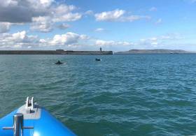
The National Yacht Club's Mal Nowlan couldn't believe his eyes on Saturday afternoon when a pod of dolphins came into the harbour to play around his boat.

'I was calibrating my RIB’s compass when DBSC’s Committee Boat 'Freebird' came into the harbour after racing. I thought my eyes were codding me as I glimpsed something rise off her bow', Mal told Afloat.ie.

Dolphins have become relatively common in the Bay in recent years but they're still a very rare sight within the harbour walls.

'I watched and saw what I reckon was a group of five dolphins escort Freebird almost to the marina break-water before turning and heading slowly back to sea', Mal said.

Reports from Scotland say, from April into May, dolphins are widely expected as the migratory salmon run picks up a bit of pace and the dolphins arrange themselves around specific places. Perhaps this is a coming trend further down the Irish Sea now too? 

The bottlenose dolphin is possibly the most socially active of the dolphin species that we get in the comparatively chilly waters of Dublin Bay. As the capital's waters have become cleaner, dolphins are popular visitors, so lets hope recent reports of murkiness don't turn them away.

Tagged under

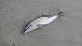
For the past six years, the first few weeks of the year have seen an increase in the number of dolphins being washed up on the Irish coastline.

The Irish Whale and Dolphin Group is making a determined effort this year to try to establish the cause and has begun the first post-mortem examinations of dead dolphins by a veterinary laboratory.

In this week’s podcast, the Chief Scientific Officer of the IWDG tells me what is being done and says that fisheries by-catch is particularly being looked at.

If there is another increase this year in the number of stranded dolphins, the IWDG is hoping the post-mortem scheme will provide a definite insight towards the cause of dolphin deaths.

Irish Whale and Dolphin Group reports eight strandings since Jan 1 ....There were two on New Year’s Day, a common dolphin in Tralee Bay and a white-beaked dolphin at Ballyconneely in Co,Galway. There have been strandings since in Counties Wexford, Clare, Mayo, Waterford and two more in Kerry.

Listen to the Podcast below.

Published in Tom MacSweeney

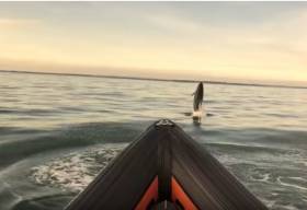
The Howth–based Coast Guard boat “Sean A Dunne” was joined by some unexpected visitors today in the form of a school of Bottlenose Dolphins.

The Coast Guard crew of four from Howth station were on routine exercise in the Irish Sea off Donabate, Co Dublin in what was flat calm clear conditions.

The dolphins joined the crew surfing the bow waves of the Coast Guard boat before heading back to deeper waters.


Published in Coastguard
Tagged under

Seán Kelly MEP (Ireland South) is calling for regular on-board inspections of supertrawlers fishing off the Irish coast to ensure that they are fully compliant with the EU Common Fisheries Policy, following a reported rise in dolphin deaths. The Fine Gael MEP is also asking the Sea-Fisheries Protection Authority (SFPA) to review and maximise its inspections when trawlers are operating off the Irish coast.

“In July 2016, in separate cases, three dead dolphins were found on the south-west coast of Ireland in the space of one week, one with a rope around its tail. These findings follow reports of a rise in the number of dead dolphins on Ireland’s west coast since the beginning of 2016.

“It is reported that large supertrawlers are currently operating around 30km off the coast of Co Kerry. While the link between supertrawler activity and the increase in these dolphin deaths is not proven, the Common Fisheries Policy (CFP) stresses that caution must be taken as regards the impact of human activity on all components of the ecosystem,” Mr Kelly stressed in an official question to the European Commission on the matter.

In a response received by Mr Kelly this week, the Commission said it “takes note of the recent death of dolphins along the south-west coast of Ireland” and that it “has tabled a revised technical measures proposal which aims to ensure better protection of cetaceans and alignment of by-catch levels to international levels. This proposal is currently being discussed by the co-legislators”.

Speaking from Brussels today (Wednesday), Mr Kelly said: “I welcome that the Commission is monitoring the situation. The Sea-Fisheries Protection Authority (SFPA) is responsible for yearly reports to the Commission, but in light of these recent reports, I am urging the SFPA to maximise inspections along the Irish coast.”

In the written response, the Commission added: “When trawlers are fishing off the Irish coast, the SFPA has access to satellite Vessel Monitoring, Automatic Identification System (AIS) and Electronic Reporting Systems (ERS) data. Regular inspections are organised at sea and at landing by the SFPA, to check compliance with the Common Fisheries Policy. The SFPA regularly reports on its control and inspection activities.”

The Commission also confirmed that it is carrying out regular audits in Ireland to ensure that Ireland is complying with its obligations and has an effective monitoring, control and surveillance system in place.

Ireland became the first European country to declare all Irish waters a dolphin and whale sanctuary in 1991.

Published in Marine Wildlife
Tagged under

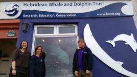
A new marine wildlife visitor centre has been launched in Tobermory on the Isle of Mull by conservation charity Hebridean Whale and Dolphin Trust – to strengthen conservation action for whales, dolphins, and porpoises, and to develop the Hebrides’ appeal as a wildlife tourism hotspot.

The Hebridean Whale and Dolphin Centre on Tobermory’s picturesque harbour front was formally opened this month, and will be a learning, training and volunteering hub, as well as providing a major attraction for visitors, including families and children.

The building’s transformation has been funded as part of a grant of almost £220,000 from the UK Government’s Coastal Communities Fund. The fully renovated and extended centre features information on sightings of cetaceans – the collective name for whales, dolphins and porpoises – interactive exhibitions, displays and a gift shop.

“Our new centre aims to put Mull and the Hebrides even more firmly on the map as a key destination to enjoy and discover world-class marine biodiversity – which in turn will boost conservation, and could bring significant economic and social benefits to the region,” said Alison Lomax, Director of Hebridean Whale and Dolphin Trust.

The centre was recently launched with a celebratory event attended by dozens of guests from across the UK, including conservationists, scientists, volunteers and local businesses.

The trust’s previous shop and visitor centre attracted 26,000 people in 2015 – a figure that Hebridean Whale and Dolphin Trust hopes will now rise significantly.

With Western Scotland’s seas being one of Europe’s most important cetacean habitats, the charity believes that developing sustainable marine wildlife eco-tourism is a major opportunity, as demonstrated by the benefits of white-tailed eagles to the local economies of Mull and Skye.

So far 24 of the world’s estimated 92 cetacean species – including many national and international conservation priority species – have been recorded in the region, and fascinating new discoveries about these populations are constantly being discovered.

The Coastal Communities Fund has also enabled the trust to carry out an innovative Sea Change project across the Hebrides over the past two years, to strengthen people’s connections to the sea in remote island communities. This has involved engagement with thousands of people, through roadshows, community visits, liaison with wildlife tourism businesses, and dozens of events.

Responsible whale watching, WiSe (Wildlife Safe) accredited, training has been provided for 23 tour boat operators, while local people have been able to develop skills through the trust’s Community Sightings Network – through which people can report sightings of cetaceans, helping to map their distribution.

Sea Change has been carried out on Mull, Coll and Tiree, Islay and Jura, Colonsay, Barra, Small Isles (Eigg, Muck, Rum, Canna), Mallaig and Arisaig, North and South Uist, Harris, Lewis, Gairloch and Skye.

The Coastal Communities Fund has also funded a refurbishment of the trust’s research yacht, Silurian, aboard which marine scientists and volunteers conduct surveys monitoring cetaceans each year. More than 90,000km of Hebridean seas have been surveyed and over 18,000 individual cetaceans recorded so far – significantly extending scientists’ knowledge and understanding, and informing long-term conservation initiatives.

Paying volunteers are being recruited for the trust’s 2016 expeditions onboard Silurian, working alongside marine scientists. For details, email [email protected], call 01688 302620 or visit www.hwdt.org.

The Coastal Communities Fund was created to direct regeneration investment to seaside towns and villages to help rebalance local economies, reduce unemployment and create work opportunities for local young people.

Published in Marine Wildlife
Tagged under

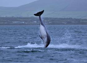
#Fungie - Dingle's resident dolphin Fungie has sustained a significant wound below his dorsal fin, as the Irish Examiner reports.

The deep cut, likely inflicted by a visiting boat's propeller, was noticed yesterday (Friday 3 June) by fans of the popular marine wildlife attraction who's delighted locals and visitors alike in Dingle for more than 30 years.

However, Fungie lovers have been urged not to panic – as the famous bottlenose has healed well from similar injuries before, and has already returned to frolicking with boaters in Dingle Harbour.

The Irish Examiner has more on the story HERE.

Published in Marine Wildlife

Electronic navigation safety technology is to be used to study the potential impacts of marine traffic on whale, dolphin and porpoise species off western Scotland in a new season of research expeditions launched by Hebridean Whale and Dolphin Trust this week.

For the first time, scientists and trained volunteers onboard the conservation charity’s specialized research yacht Silurian will use an Automatic Identification System (AIS) transponder to collect detailed data on other vessels’ movements. This will be combined with sightings and underwater acoustic monitoring of cetaceans – the collective name for whales, dolphins and porpoises – to gain new insights into how species are affected by ships’ movements and noise.

AIS – an automatic tracking system that electronically identifies and locates nearby vessels, continuously transmitting details of their identity, position, speed and course – is more commonly used in navigation safety, allowing ships to ‘see’ each other in all conditions.

With marine traffic from a large range of industries growing, known threats or pressures for cetaceans from shipping include ship-strikes – in which vessels accidentally hit whales – and noise pollution from poorly designed or poorly maintained vessels, which can mask out whale sounds used for communication and navigation.

Dr Conor Ryan, Hebridean Whale and Dolphin Trust Science Officer, said: “This innovative approach provides us with an opportunity to enhance our long-term research, which is providing unprecedented insights into the distribution and range of cetaceans in Scotland’s seas, as well as the challenges they face – including the unintentional consequences of human activities.

“The Hebrides may seem like a wilderness, but human impacts on the marine environment are significant – and likely to increase with expansions in marine industries, such as aquaculture and renewable installations. Strengthening scientific understanding is crucial if we are to help industries ensure that their impacts on Scotland’s remarkable whales, dolphins and porpoise populations are minimal.”

The new AIS transponder on Silurian will also allow closer public engagement with the trust’s research expeditions. By using the research vessel’s unique Maritime Mobile Service Identity (MMSI) number 232004280, people will be able to follow Silurian’s progress around Scotland’s west coast in real-time via www.hwdt.org.

Equipping Silurian with AIS technology has been made possible by a grant of £94,000 from the UK Government’s Coastal Communities Fund. This grant has also funded a major refurbishment of the yacht, including an environmentally friendly and long-lasting copper coating for the hull that will ensure the vessel remains seaworthy for the next decade, alongside other activities.

Hebridean Whale and Dolphin Trust – based in Tobermory on the Isle of Mull – is recruiting paying volunteers for its surveys. Between May and October, there will be 12 separate expeditions, each lasting between one and two weeks. This includes two ‘Teen Teams’ reserved for 16-17 year olds.

These volunteers will work and sleep on Silurian, receiving specialist training and working with scientists – conducting visual surveys, acoustic monitoring, and cetacean identification through dorsal fin photography. They will also be able to develop sailing and navigation skills as they visit some of Britain’s most remote and wild corners.

Silurian has been the platform for Hebridean Whale and Dolphin Trust’s unique research programme since 2002, welcoming aboard over 60 volunteers annually, surveying tens of thousands of nautical miles and logging every cetacean encounter made. This year, the yacht will welcome her 800th volunteer aboard. The yacht is also used as a floating classroom for marine conservation education for schoolchildren and students.

Western Scotland’s seas are one of Europe’s most important habitats for cetaceans with 24 of the world’s estimated 92 cetacean species recorded in the region to date. Many of these are national and international conservation priority species.

As well as strengthening knowledge about cetaceans and contributing to recommendations to safeguard them, the trust’s surveys are important because cetaceans are apex predators at the top of the marine food web, and so can act as indicators of the marine environment’s overall health.

The 2016 surveys depart from Tobermory on the Isle of Mull, Kyle of Lochalsh or Ullapool. The new addition of Ullapool as a rendezvous point will allow the trust to carry out more surveys in the remoter corners of its study area. Areas covered depend on the weather but will range from Mull of Kintyre in the south, Cape Wrath in the north and St Kilda in the west.

Participation costs cover boat expenses, accommodation, training, food and insurance, and support the charity’s research. For details, email [email protected], call 01688 302620 or visit www.hwdt.org.

Published in Marine Wildlife
Tagged under

#orca – Crews from commercial and Royal Navy vessels have started training for the Orca Ocean Watch Week, an initiative by the whale and dolphin conservation charity ORCA, that is being launched at Portsmouth International Port this month.

Between 25th July and 2nd August bridge crews are being asked to report all sightings of whales, dolphins and porpoises as they sail to and from Portsmouth International Port. The records they produce will help ORCA develop the clearest picture yet of just where the much loved marine mammals are living.

The enthusiastic team from ORCA have spent time training crews from a wide variety of operators, including the banana boats that come and go on a regular basis from the Caribbean and Central America. They've also spent time with the Royal Navy, briefing crews from Portsmouth based vessels.

The Royal Navy ships HMS Smiter, HMS Puncher, HMS Explorer and HMS Trumpeter will be sailing through the English Channel, down into the Northern Bay of Biscay and up into the Baltic Sea. These ships are among 11 vessels contributing to the activity from the 1st Patrol Boat Squadron that are operating all over Western Continental Europe and the British Isles.

Lieutenant Commander Phil Houghton of the 1st Patrol Boat Squadron said, "The Royal Navy and in particular 1PBS are delighted to be able to participate in OceanWatch 2015 and do what they can to support the better appreciation of the complex and vulnerable marine environment in which we operate. Only by understanding the animals and habitats around our local waters can we provide the appropriate protection for them."

Orca Ocean Watch Week will be launched on Monday 20th July by television wildlife expert Nigel Marven. Nigel will be joined at the new passenger terminal at Portsmouth International Port by a 50 foot, life-sized model of a blue whale, and school children eager to learn more about the variety of wildlife in the seas off Portsmouth.

By the time Ocean Watch Week is underway ORCA will have trained crews from over 20 vessels, including ferries, freight ships, cruise liners and small ships.

If you're interested in spotting these fantastic animals yourself, Brittany Ferries and ORCA offer Whale Watching mini cruises from Portsmouth, an increasingly popular trip across the Bay of Biscay, which is one of the most important habitats for whales and dolphins on the planet. ORCA is also working with operators at other ports along the South Coast and Scotland, attempting to get the widest coverage possible for its important survey.

Published in Marine Wildlife
Tagged under

#MarineWildlife - Cute by name, cute by nature: Sherkin, Buoy and Splash were returned to the wild after being nursed back to health by the volunteers at Seal Rescue Ireland.

As the Irish Examiner reports, the three young seals – rescued after tips from the public from locations in Cork and Kerry – were rehabilitated over the past three months at the new marine wildlife refuge in Courtown.

But they were finally fit to return to the open water last weekend at Fountainstown beach in Co Cork. The Irish Examiner has much more HERE.

As three return to Irish waters, another says adieu – as Clet the lone dolphin has now been spotted off the Dorset coast, according to the Bournemouth Echo.

Last spotted between Ireland and Scotland's west coast in December, the solitary cetacean first noted in French waters in 2008 appears to have completed a full loop around the island of Ireland.

Along the way he bypassed Dingle's famous resident Fungie and spent a few days in the company of fellow 'dolphina-non-grata' Sandy, also known as Dusty.

Now he's attracting the attention of locals at Portland, south of Weymouth, across the English Channel from his original splashing grounds.

Closer to home, conservationists in the the North West of England have released a video documenting the wealth of wildlife living in the Irish Sea as a reminder to political movers and shakers of the importance of its protection.

Groups such as the North West Wildlife Trusts have criticised Westminster for 'lack of ambition' over the past year since plans for a network of well over 100 Marine Conservation Zones (MCZs) were scaled back to just 27 approvals in November 2013.

More recently a further 23 MCZs were designated proposed, only two of which are out of out of seven proposals covering the waters between Britain's west coast and Ireland (updated Tuesday 17 March).

Published in Marine Wildlife

#MarineWildlife - The swimmer who suffered serious injuries when she was attacked by Doolin's formerly resident dolphin has spoken of the "pure terror" of the incident last summer.

As previously reported on Afloat.ie, the woman was hospitalised after being stuck by the snout of Dusty the dolphin, whose behaviour had grown increasingly hostile towards swimmers in the Co Clare harbour over the summer.

Valerie Ryan spoke out some weeks later over the incident, calling for a total swimming ban in the area as she outlined the extent of her injuries, which included eight spinal fractures, two broken ribs and lung damage.

More recently, she recounted her experience for the Guardian, noting how Dusty "went ballistic" after she entered the water to join another swimmer ("I found out afterwards that she's very territorial when she us with somebody") and rammed Ryan from behind before she could climb out.

"All these people on the pier were staring down at me open-mouthed," she recalls. "Dusty was still in the water beside me, her tail flapping crazily. That was more frightening than anything: I thought, if she hits me with her tail, I could go under; I’m gone."

Yet despite the shock of that day, Ryan says she doesn't have "any anger towards Dusty. I respect her. But I was in her territory and she’s a wild, unpredictable animal. People need to know that."

The Guardian has much more on the story HERE.

Published in Marine Wildlife
Page 2 of 5

General Information on using Waterways Ireland inland navigations

Safety on the Water

All users of the navigations are strongly recommended to make themselves aware of safety on the water for whatever activity they are involved in and to read the advice offered by the various governing bodies and by:

The Dept. of Transport, Ireland: www.gov.ie/transport and The Maritime and Coastguard Agency, UK, The RNLI – Water Safety Ireland for information in terms of drowning prevention and water safety.

Registration of Vessels

All vessels using the Shannon Navigation, which includes the Shannon-Erne Waterways and the Erne System must be registered with Waterways Ireland. Only open undecked boats with an engine of 15 horsepower or less on the Shannon Navigation, and vessels of 10 horsepower or less on the Erne System, are exempt. Registration is free of charge.

Craft registration should be completed online at: https://www.waterwaysireland.org/online-services/craft-registration

Permits for use of the Grand and Royal Canals and the Barrow Navigation

All vessels using the Grand and Royal Canals and the Barrow Navigation must display appropriate valid Permit(s) i.e A Combined Mooring and Passage Permit (€126) and if not intending to move every five days, an Extended Mooring Permit (€152).

Permit applications should be completed online at: https://www.waterwaysireland.org/online-services/canal-permits

Passage on the Royal and Grand Canals – Dublin Area

For boat passage through the locks east of Lock 12 into / out of Dublin on either the Royal or Grand Canals, Masters are requested to contact the Waterways Ireland Eastern Regional Office (M-F 9.30am-4.30pm) on tel: +353(0)1 868 0148 or email [email protected] prior to making passage in order to plan the necessary lock-keeping assistance arrangements.

On the Grand Canal a minimum of two days notice prior to the planned passage should be given, masters should note that with the exception of pre-arranged events, a maximum of 2 boats per day will be taken through the locks, travelling either east or west.

Movements in or out of the city will be organised by prior arrangement to take place as a single movement in one day. Boaters will be facilitated to travel the system if their passage is considered to be safe by Waterways Ireland and they have the valid permit(s) for mooring and passage.

Newcomen Lifting Bridge

On the Royal Canal two weeks’ notice of bridge passage (Newcomen Lifting Bridge) is required for the pre-set lift date, and lock assistance will then also be arranged. A minimum of 2 boats is required for a bridge lift to go ahead.

Waterways Ireland Eastern Regional Office (Tel: +353(0)1 868 0148 or [email protected] ) is the point of contact for the bridge lift.

A maximum number of boats passing will be implemented to keep to the times given above for the planned lifts (16 for the Sat / Sun lifts & 8 for the weekday lifts). Priority will be given on a first come first served basis.

On day of lift, boaters and passengers must follow guidance from Waterways Ireland staff about sequence of passage under bridge & through Lock 1, and must remain within signed and designated areas.

Events Held on the Waterways

All organised events taking place on the waterways must have the prior approval of Waterways Ireland. This is a twelve week process and application forms must be accompanied with the appropriate insurance, signed indemnity and risk assessment. The application should be completed on the Waterways Ireland events page at :

https://www.waterwaysireland.org/online-services/event-approval

Time Limits on Mooring in Public Harbours

On the Shannon Navigation and the Shannon-Erne Waterway craft may berth in public harbours for five consecutive days or a total of seven days in any one month.

On the Erne System, revised Bye Laws state that: No master or owner shall permit a vessel, boat or any floating or sunken object to remain moored at or in the vicinity of any public mooring, including mooring at any other public mooring within 3 kilometres of that location, for more than 3 consecutive days and shall not moor at that same mooring or any other public mooring within 3 kilometres of that location within the following 3 consecutive days without prior permission by an authorised official.

Winter Mooring on the Shannon Navigation and Shannon Erne Waterway

Winter mooring may be availed of by owners during the period 1 Nov to 31 Mar by prior arrangement and payment of a charge of €63.50 per craft. Craft not availing of Winter Mooring must continue to comply with the “5 Day Rule”. Winter Mooring applications should be completed online at : https://www.waterwaysireland.org/online-services/winter-moorings-booking

Owners should be aware that electricity supply and water supply to public moorings is disconnected for the winter months. This is to protect against frost damage, to reduce running costs and to minimise maintenance requirements during the winter months.

Vessel owners are advised that advance purchasing of electricity on the power bollards leading up to the disconnection date should be minimal. Electricity credit existing on the bollards will not be recoverable after the winter decommissioning date. Both services will be reinstated prior to the commencement of the next boating season.

Smart Cards

Waterways Ireland smart cards are used to operate locks on the Shannon Erne Waterway, to access the service blocks, to use the pump-outs along the navigations, to avail of electrical power at Waterways Ireland jetties.

Berthing in Public Harbours

Masters are reminded of the following:

  • Equip their vessel with mooring lines of appropriate length and strength and only secure their craft to mooring bollards and cleats provided for this purpose.
  • Ensure the available berth is suitable to the length of your vessel, do not overhang the mooring especially on finger moorings on floating pontoon moorings.
  • Ensure mooring lines, electric cables and fresh water hoses do not create a trip hazard on public jetties for others users.
  • Carry sufficient fenders to prevent damage to your own vessel, other vessels and WI property.
  • Allow sufficient space between your vessel and the vessel ahead /astern (c.1m) for fire safety purposes and /or to recover somebody from the water.
  • Do not berth more than two vessels side by side and ensure there is safe access/egress at all times between vessels and onto the harbour itself.
  • Do not berth in such a way to prevent use of harbour safety ladders, slipways or pump-outs.
  • Do not allow the bow of your vessel to overhang the walkway of a floating mooring thus creating a hazard for others with an overhanging anchor or bow fendering.
  • Animals are not allowed to be loose or stray at any time.
  • Harbour and jetty infrastructure such as railings, power pedestals, fresh water taps, electric light poles, safety bollards, ladders etc are not designed for the purpose of mooring craft , they will not bear the strain of a vessel and will be damaged.
  • At Carrybridge on the Erne System, Masters of vessels are not permitted to use stern on mooring. Masters of vessels must use the mooring fingers for mooring of vessels and for embarkation / disembarkation from vessels.

Passenger Vessel Berths

Masters of vessels should not berth on passenger vessel berths where it is indicated that an arrival is imminent. Passenger vessels plying the navigations generally only occupy the berths to embark and disembark passengers and rarely remain on the berths for extended periods or overnight.

Lock Lead-in Jetties

Lead-in jetties adjacent to the upstream and downstream gates at lock chambers are solely for the purpose of craft waiting to use the lock and should not be used for long term berthing.

Vessel Wake

Vessel wake, that is, the wave generated by the passage of the boat through the water, can sometimes be large, powerful and destructive depending on the hull shape and engine power of the vessel. This wake can be detrimental to other users of the navigation when it strikes their craft or inundates the shoreline or riverbank. Masters are requested to frequently look behind and check the effect of their wake / wash particularly when passing moored vessels, on entering harbours and approaching jetties and to be aware of people pursuing other activities such as fishing on the riverbank.

Speed Restriction

A vessel or boat shall not be navigated on the Shannon Navigation at a speed in excess of 5 kph when within 200 metres of a bridge, quay, jetty or wharf, when in a harbour or canal or when passing within 100 metres of a moored vessel or boat.

Vessels navigating the Shannon-Erne Waterway should observe the general 5 kph speed limit which applies along the waterway. This is necessary in order to prevent damage to the banks caused by excessive wash from vessels.

Vessels navigating the Erne System should observe the statutory 5kt / 6mph / 10kph speed limit areas.

A craft on the Royal and Grand canals shall not be navigated at a speed in excess of 6km per hour.

A craft on the Barrow Navigation shall not be navigated at a speed in excess of 11km per hour except as necessary for safe navigation in conditions of fast flow.

Bank Erosion

Narrow sections of all the navigations are particularly prone to bank erosion due to the large wash generated by some craft. Masters are requested to be vigilant and to slow down to a speed sufficient to maintain steerage when they observe the wash of their craft inundating the river banks.

Unusual Waterborne Activity

Unusual waterborne vessels may be encountered from time to time, such as, hovercraft or amphibious aircraft / seaplanes. Masters of such craft are reminded to apply the normal “Rule of the Road” when they meet conventional craft on the water and to allow extra room to manoeuvre in the interest of safety.

Sailing Activity

Mariners will encounter large numbers of sailing dinghies from late June to August in the vicinity of Lough Derg, Lough Ree and Lower Lough Erne. Sailing courses are marked by yellow buoys to suit weather conditions on the day. Vessels should proceed at slow speed and with due caution and observe the rules of navigation when passing these fleets, as many of the participants are junior sailors under training.

Rowing

Mariners should expect to meet canoes and vessels under oars on any part of the navigations, but more so in the vicinity of Athlone, Carrick-on-Shannon, Coleraine, Enniskillen and Limerick. Masters are reminded to proceed at slow speed and especially to reduce their wash to a minimum when passing these craft as they can be easily upset and swamped due to their very low freeboard and always be prepared to give way in any given traffic situation.

Canoeing

Canoeing is an adventure sport and participants are strongly recommended to seek the advice of the sport’s governing bodies i.e Canoeing Ireland and the Canoe Association of Northern Ireland, before venturing onto the navigations.

Persons in charge of canoes are reminded of the inherent danger to these craft associated with operating close to weirs, sluice gates, locks and other infrastructure particularly when rivers are in flood and large volumes of water are moving through the navigations due to general flood conditions or very heavy localised precipitation e.g. turbulent and broken water, stopper waves. Shooting weirs is prohibited without prior permission of Waterways Ireland.

Canoeists should check with lockkeepers prior entering a lock to ensure passage is done in a safe manner. Portage is required at all unmanned locks.

Canoe Trail Network – "Blueways"

Masters of powered craft are reminded that a canoe trail network is being developed across all navigations and to expect more organised canoeing along these trails necessitating slow speed and minimum wash when encountering canoeists, rowing boats etc

Rockingham and Drummans Island Canals – Lough Key

It is expected that work on Rockingham and Drummans Island Canals on Lough Key will be completed in 2021. Access to these canals will be for non-powered craft only, eg canoes, kayaks, rowing boats.

Fast Powerboats and Personal Watercraft (Jet Skis)

Masters of Fast Powerboats (speed greater than 17kts) and Personal Watercraft (i.e.Jet Skis) are reminded of the inherent dangers associated with high speed on the water and especially in the confines of small bays and narrow sections of the navigations. Keeping a proper look-out, making early alterations to course and /or reducing speed will avoid conflict with slower vessels using the navigation. Personal Watercraft are not permitted to be used on the canals.

Towing Waterskiers, Wakeboarders, Doughnuts etc

Masters of vessels engaged in any of these activities are reminded of the manoeuvring constraints imposed upon their vessel by the tow and of the added responsibilities that they have to the person(s) being towed. These activities should be conducted in areas which are clear of conflicting traffic. It is highly recommended that a person additional to the master be carried to act as a “look-out” to keep the tow under observation at all times.

Prohibition on Swimming

Swimming in the navigable channel, particularly at bridges, is dangerous and is prohibited due to the risk of being run over by a vessel underway in the navigation.

Age Restrictions on operating of powered craft

In the Republic of Ireland, Statutory Instrument 921 of 2005 provides the legal requirements regarding the minimum age for operating of powered craft. The Statutory Instrument contains the following requirements:

- The master or owner of a personal watercraft or a fast power craft shall take all reasonable steps to ensure that a person who has not attained the age of 16 years does not operate or control the craft

- The master or owner of a pleasure craft powered by an engine with a rating of more than 5 horse power or 3.7 kilowatts shall take all reasonable steps to ensure that a person who has not attained the age of 12 years does not operate or control the craft.

Lifejackets and Personal Flotation Devices (PFDs)

Lifejackets and PFD’s are the single most important items of personal protective equipment to be used on a vessel and should be worn especially when the vessel is being manoeuvred such as entering / departing a lock, anchoring, coming alongside or departing a jetty or quayside.

In the Republic of Ireland, Statutory Instrument 921 of 2005 provides the legal requirements regarding the wearing of Personal Flotation Devices. The Statutory Instrument contains the following requirements:

- The master or owner of a pleasure craft (other than a personal watercraft) shall ensure, that there are, at all times on board the craft, sufficient suitable personal flotation devices for each person on board.

- A person on a pleasure craft (other than a personal watercraft) of less than 7 metres length overall shall wear a suitable personal flotation device while on board an open craft or while on the deck of decked craft, other than when the craft is made fast to the shore or at anchor.

- The master or owner of a pleasure craft (other than a personal watercraft) shall take all reasonable steps to ensure that a person who has not attained the age of 16 years complies with paragraph above.

- The master or owner of a pleasure craft (other than a personal watercraft), shall take all reasonable steps to ensure that a person who has not attained the age of 16 years wears a suitable personal flotation device while on board an open craft or while on the deck of a decked craft other than when it is made fast to the shore or at anchor.

- The master or owner of a pleasure craft (other than a personal watercraft) shall take all reasonable steps to ensure that a person wears a suitable personal flotation device, at all times while – (a) being towed by the craft, (b) on board a vessel or object of any kind which is being towed by the craft.

Further information is available at: http://www.irishstatutebook.ie/eli/2005/si/921/made/en/print

Firing Range Danger Area – Lough Ree

The attention of mariners is drawn to the Irish Defence Forces Firing Range situated in the vicinity of buoys No’s 2 and 3, on Lough Ree on the Shannon Navigation. This range is used regularly for live firing exercises, throughout the year, all boats and vessels should stay clear of the area marked with yellow buoys showing a yellow "X" topmark and displaying the word "Danger".

Shannon Navigation, Portumna Swing Bridge Tolls

No attempt should be made by Masters’ of vessels to pay the bridge toll while making way through the bridge opening. Payment will only be taken by the Collector from Masters when they are secured alongside the jetties north and south of the bridge.

Navigating from Killaloe to Limerick on the Shannon Navigation

The navigation from Killaloe to Limerick involves passage through Ardnacrusha locks, the associated headrace and tailrace and the Abbey River into Limerick City. Careful passage planning is required to undertake this voyage. Considerations include: lock passage at Ardnacrusha, water flow in the navigation, airdraft under bridges on Abbey River in Limerick, state of tide in Limerick

Users are advised to contact the ESB Ardnacrusha hydroelectric power station (00353 (0)87 9970131) 48 hours in advance of commencing their journey to book passage through the locks at Ardnacrusha. It is NOT advised to undertake a voyage if more than one turbine is operating (20MW), due to the increased velocity of flow in the navigation channel, which can be dangerous. To ascertain automatically in real time how many turbines are running, users can phone +353 (0)87 6477229.

For safety reasons the ESB has advised that only powered craft with a capacity in excess of 5 knots are allowed to enter Ardnacrusha Headrace and Tailrace Canals.

Passage through Sarsfield Lock should be booked on +353-87-7972998, on the day prior to travel and it should be noted also that transit is not possible two hours either side of low water.

A Hydrographic survey in 2020 of the navigation channel revealed that the approach from Shannon Bridge to Sarsfield Lock and the Dock area has silted up. Masters of vessels and water users are advised to navigate to the Lock from Shannon bridge on a rising tide one or two hours before High Tide.

Lower Bann Navigation

The attention of all users is drawn to the “Users Code for the Lower Bann”, in particular to that section covering “Flow in the River” outlining the dangers for users both on the banks and in the navigation, associated with high flow rates when the river is in spate. Canoeists should consult and carry a copy of the “Lower Bann Canoe Trail” guide issued by the Canoe Association of Northern Ireland. Users should also contact the DfI Rivers Coleraine, who is responsible for regulating the flow rates on the river, for advisory information on the flow rates to be expected on any given day.

DfI Rivers Coleraine. Tel: 0044 28 7034 2357 Email: [email protected]

Lower Bann Navigation – Newferry – No wake zone

A No Wake Zone exists on the Lower Bann Navigation at Newferry. Masters of vessels are requested to proceed at a slow speed and create no wake while passing the jetties and slipways at Newferry.

Overhead Power Lines (OHPL) and Air draft

All Masters must be aware of the dangers associated with overhead power lines, in particular sailing vessels and workboats with cranes or large air drafts. Voyage planning is a necessity in order to identify the location of overhead lines crossing the navigation.

Overhead power line heights on the River Shannon are maintained at 12.6metres (40 feet) from Normal Summer level for that section of navigation, masters of vessels with a large air draft should proceed with caution and make additional allowances when water levels are high.

If a vessel or its equipment comes into contact with an OHPL the operator should NOT attempt to move the vessel or equipment. The conductor may still be alive or re-energise automatically. Maintain a safe distance and prevent third parties from approaching due to risk of arcing. Contact the emergency services for assistance.

Anglers are also reminded that a minimum ground distance of 30 metres should be maintained from overhead power lines when using a rod and line.

Submarine Cables and Pipes

Masters of vessels are reminded not to anchor their vessels in the vicinity of submarine cables or pipes in case they foul their anchor or damage the cables or pipes. Look to the river banks for signage indicating their presence.

Water Levels - Precautions

Low Water Levels:

When water levels fall below normal summer levels masters should be aware of:

Navigation

To reduce the risk of grounding masters should navigate on or near the centreline of the channel, avoid short cutting in dog-legged channels and navigating too close to navigation markers.

Proceeding at a slow speed will also reduce “squat” effect i.e. where the vessel tends to sit lower in the water as a consequence of higher speed.

Slipways

Reduced slipway length available under the water surface and the possibility of launching trailers dropping off the end of the concrete apron.

More slipway surface susceptible to weed growth requiring care while engaged in launching boats, from slipping and sliding on the slope. Note also that launching vehicles may not be able to get sufficient traction on the slipway once the craft is launched to get up the incline.

Bank Erosion

Very dry riverbanks are more susceptible to erosion from vessel wash.

Lock Share

Maximising on the number of vessels in a lock will ensure that the total volume of water moving downstream is decreased. Lock cycles should be used for vessels travelling each way.

High Water Levels:

When water levels rise above normal summer level masters should be aware of:

Navigation

Navigation marks will have reduced height above the water level or may disappear underwater altogether making the navigable channel difficult to discern.

In narrow sections of the navigations water levels will tend to rise more quickly than in main streams and air draft at bridges will likewise be reduced.

There will also be increased flow rates particularly in the vicinity of navigation infrastructure such as bridges, weirs, locks etc where extra care in manoeuvring vessels will be required.

Harbours and Jetties

Due care is required in harbours and at slipways when levels are at or near the same level as the harbour walkways' as the edge will be difficult to discern especially in reduced light conditions. It is advised that Personal Flotation Devices be worn if tending to craft in a harbour in these conditions.

Slipways

Slipways should only be used for the purpose of launching and recovering of water craft or other objects from the water. Before using a slipway it should be examined to ensure that the surface has sufficient traction/grip for the intended purpose such as launching a craft from a trailer using a vehicle, that there is sufficient depth of water on the slipway to float the craft off the trailer before the concrete apron ends and that the wheels of the trailer do not drop off the edge of the slipway. That life-saving appliances are available in the vicinity, that the vehicle is roadworthy and capable of coping with the weight of the trailer and boat on the incline. It is recommended that slipway operations are conducted by two persons.

Caution to be Used in Reliance upon Aids to Navigation

The aids to navigation depicted on the navigation guides comprise a system of fixed and floating aids to navigation. Prudent mariners will not rely solely on any single aid to navigation, particularly a floating aid to navigation. With respect to buoys, the buoy symbol is used to indicate the approximate position of the buoy body and the ground tackle which secures it to the lake or river bed. The approximate position is used because of the practical limitations in positioning and maintaining buoys in precise geographical locations. These limitations include, but are not limited to, prevailing atmospheric and lake/river conditions, the slope of and the material making up the lake/river bed, the fact that the buoys are moored to varying lengths of chain, and the fact that the buoy body and/or ground tackle positions are not under continuous surveillance. Due to the forces of nature, the position of the buoy body can be expected to shift inside and outside the charted symbol.

Buoys and perches are also moved out of position or pulled over by those mariners who use them to moor up to instead of anchoring. To this end, mariners should always monitor their passage by relating buoy/perch positions with the published navigation guide. Furthermore, a vessel attempting to pass close by always risks collision with a yawing buoy or with the obstruction that the buoy or beacon/perch marks.

Masters of Vessels are requested to use the most up to date Navigation guides when navigating on the Inland Waterways.

Information taken from Special Marine Notice No 1 of 2023