


Displaying items by tag: Donegal
Ireland’s Donegal Puts Itself On The Cruising Map
Rugged Donegal in the far northwest of Ireland is unknown territory for many Irish people whether by land or sea - and even more so for people from further afield writes W M Nixon. Yet for people who live in this picturesque but challenging region, it’s the hub of the universe, and for Donegal-located sailing enthusiasts, it can be a cruising paradise.
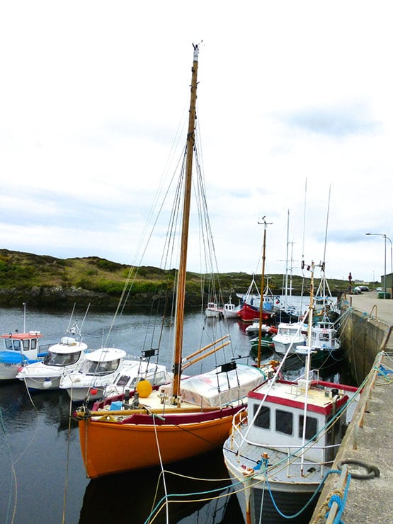
This was brought home to the rest of us at the recent Irish Cruising Club prize-giving, when the Glengarriff Trophy for the best cruise in Irish waters went to Dr Paul McSorley, who sails from Lough Swilly. Despite 2015’s mixed weather, he made a very detailed cruise of the Donegal coast with his daughter Eimile in the 27ft International H Boat Wild Cat. While the H Boats were developed in Finland as a fast weekend cruiser with genuine race potential (they’re now an International Racing Class), it’s unlikely that designer Hans Groop envisaged them cruising the monumental Donegal coast with its challenging location on the Wild Atlantic Way.
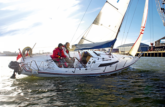 An H Boat in cruising mode. Paul & Eimile McSorley’s cruise in Donegal in 2015 with with the H Boat Wild Cat was awarded an ICC Trophy
A Land Apart – Donegal is Ireland’s ultimate cruising challenge
Yet on a good day, you could see resemblances between the myriad of islands on the Finnish coast and the maze of islands north and south of Arranamore between Dawros Head and Bloody Foreland, the area on which Wild Cat’s cruise was concentrated. The difference, of course, is the tide. But Donegal aficionados reckon that the tide adds a special spice in which the Baltic is woefully lacking……
Whatever, there’s no doubt that Donegal is a special place for many cruising folk, and in recent days the ever-curious Norman Kean and Geraldine Hennigan of Courtmacsherry, who edit the Irish Cruising Club Sailing Directions, have been in Donegal sussing out welcome new developments. In a sense, it was something of a home-coming, for when Norman first came from Scotland to settle in Ireland to work in a chemical plant in Derry, Lough Swilly Yacht Club became his home base, and it was a cruise from there to the Faroes in an own-built Sadler 25 which first put him on the cruising map.
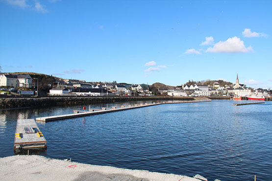
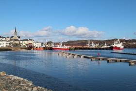
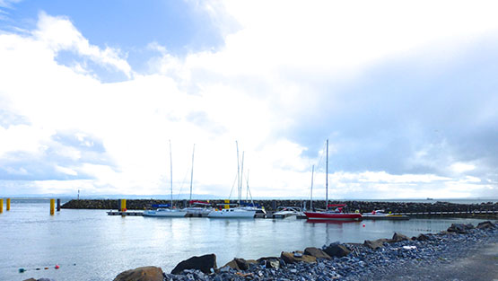
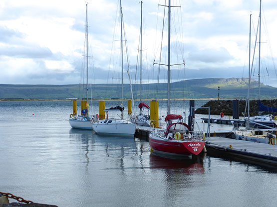
This is the start of something very worthwhile – the first pontoon berths in place in Killybegs in Donegal last week. Photo: Geraldine Hennigan
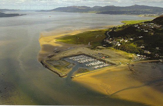
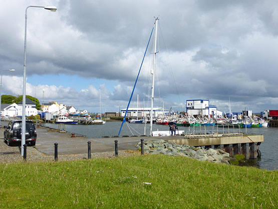
In Donegal in late February 2016, they found that the further you go south, the more promising are the developments. Best of all is the mighty fishing port of Killybegs on the south coast facing into Donegal Bay, a wonderful natural harbour for a bustling place which is said to be a town of 23 millionaires. For although not everyone does well in the fishing, some busy and innovative types do very well indeed.
For quite some time there’s been talk of the provision of pontoon facilities in Killybegs, but for 2016 Donegal County Council - where Cathal Sweeney has become the enthusiastic harbour engineer - have just gone ahead and done it with a minimum of fanfare, installing a 63-berth pontoon setup with plenty of room for expansion. (As first reported by Afloat.ie in March 2013). The pontoons were supplied and fitted by Oliver Shortall's Inland and Coastal Marinas Ltd of Banagher in County Offaly.
At present it’s called a “Small Craft Harbour”, which at first you might think reflects the reluctance of local authorities, the further north you go in Ireland, to describe a new amenity of this type as a “marina”. A case in point is Ardglass in County Down where the excellent little marina – one of the greatest boons to East Coast cruising – is still referred to as the “Phenick Cove Boat Park”.
On the other hand, Cathal Sweeney sounds a no-nonsense kind of guy, so maybe he won’t describe the very welcome new facility in Killybegs – which will transform Donegal as a cruising ground in providing a convenient base where a boat could be confidently left with good if distant communications with the rest of the country – as a marina until it has the full shoreside facilities.
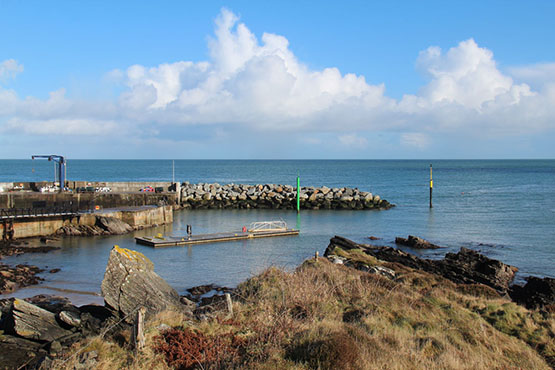
Then the cruising options from Killybegs have been improved too, as to the westward a fine big pontoon has now been provided at the west pier in the lovely inlet of Teelin right beside the majestic cliffs of Slieve League. But then as we head north along the massive Atlantic seaboard, proper facilities are sparse enough, though in the case of both Burtonport and Bunbeg, it’s surely only a matter of time before a proper recreational-use pontoon or two gets installed.
Bunbeg on Donegal’s northwest corner is a little port which would benefit from a modest pontoon facility. Photo: W M Nixon
Cruising Donegal’s north coast, it still remains a source of wonder and delight that Tory Island now has a proper pier, albeit a tiny one, at which a cruising yacht can confidently overnight. And further east we hear that the most sheltered anchoring spot on the entire north coast, Fanny’s Bay on the west side just inside the entrance to Mulroy Bay, is a real possibility for a small marina facility.
Nevertheless in cruising Donegal, your first requirement is for your vessel to have her own fully operational and very substantial ground tackle, for apart from this being the seamanlike approach, the choice of anchorages which opens up when you know you’ve an anchor which will hold, and a windlass which will retrieve it, is almost boundless.
After many years, the shoreside cohesion of Fahan Marina on Lough Swilly with its landward neighbourhood south of Buncrana still seems a long way off. Photo Kevin Dwyer/Courtesy ICC
In the northeast of this enormous county of Donegal, there has of course long been a convenient if somewhat tide-ridden pontoon at Rathmullan on the west shore of Lough Swilly, but across-lough at Fahan, the marina – the great white hope of Donegal sailing – continues in a sort of semi-functional limbo, an unfinished, disconnected piece of work which nevertheless gives enough hint of what might be, if only someone could find a way through various legal and commercial impasses.
The berthing facility at Bunnagee near Culdaff took a battering in the winter storms. Photo: Geraldine Hennigan
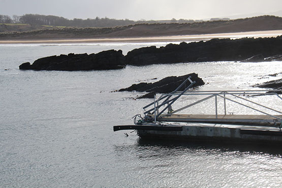
Storm damage to one of the Bunagee pontoons. Photo: Geraldine Hennigan
Up to the north of Inishowen, what was hoped to be a “marina” at the lovely little bay of Bunagee at Culdaff has seen its pontoon damaged in winter storms, for even in summer this is a restless if attractive anchorage. But on the east coast of Inishowen the Greencastle-Moville area has seen significant improvement with summer harbour for Moiville Yacht Club close south of Greencastle, where the main harbour itself has seen work resumed on some improvements.
Greencastle is a fishing port where occasionally working boats and leisure craft can become very crowded……Photo: W M Nixon
 ….but immediately south of Greencastle this new pontoon facility provides a summer berth for local craft. Photo: W M Nixon
The new Greencastle pontoons looking east across Lough Foyle. In time, an additional sheltering pier may make this a more attractive proposition for visiting cruising boats. Photo: W M Nixon
So Donegal calls. It may get some of the roughest weather in Europe, but when summer comes to stay for a week or two, it’s a cruising paradise.
Boat Modifications May Have Led To Fisherman's Drowning Says MCIB Report
#MCIB - Unapproved modifications to a lobster boat may have contributed to the loss of a crewman off Donegal last summer, according to the official report into the incident.
As previously reported on Afloat.ie, the man died after falling overboard from the fishing vessel off Horn Head on Tuesday 16 June.
He was one of two crew on the MFV Our Jenna, which had set out from Portnablagh that morning to haul and shoot lobster pots, as detailed in the Marine Casualty Investigation Board (MCIB) report.
Sometime after baited pots had been set out ready to shoot, the skipper left his crewman, who was not wearing a personal floation device (PFD), on deck as he went to the wheelhouse to set the next waypoint and navigate to the location.
However, on arrival he looked out the wheelhouse door to see the crewman in the water off the starboard quarter, conscious and waving his arms – though he was not able to swim.
The skipper attempted a rescue with lifebuoys but the crewman was able to grasp them, prompting the skipper to bring the vessel right alongside and pass a line around the crewman's waist to try to haul him above the waterline in what were described as choppy conditions.
However, reports indicate that the crewman had lost consciousness by the time the skipper raised the alarm over VHF radio, and emergency services were unable to revive him when they reached the vessel some 45 minutes later. The cause of death was confirmed as drowning.
With no witnesses to the incident, it is not clear precisely how the crewman went overboard.
But the MCIB identified a more than two-metre opening in the transom bulwark created after the vessel's most recent Document of Compliance with the Code of Practice has been issued – a modification that would not have conformed to standards.
Similarly, rubber laid on the deck after the boat's last appraisal was of conveyer-belt grade without the same anti-slip properties as dedicated marine matting.
Any combinations of these factors could have resulted in the crewman going overboard, the report concludes.
The MCIB also noted that while not mandatory, the use of a safety harness "could well have prevented the incident from occurring", and the report recommends relevant changes to the Code of Practice.
The full MCIB report into the MFV Our Jenna incident on 15 June 2015 is attached below.
Donegal TD Pushes Minister To Raise Issue Of Bluefin Quota With EU
#Bluefin- A Donegal TD's push for a bluefin tuna quota for local game anglers has prompted a meeting between Marine Minister Simon Coveney and the EU Fisheries Commissioner.
According to Donegal Now, Thomas Pringle TD has welcomed the move to request a three-tonne quota for bluefin "despite the fact that I’ve brought this proposal before the Dáil on a number of occasions over the past year".
As previously reported on Afloat.ie, Inland Fisheries Ireland said that any initiative to develop a catch-and-release fishery for bluefin in Irish waters would demand struct protocols and reporting to the International Commission for the Conservation of Atlantic Tunas (ICCAT).
But the independent Dáil deputy says recreational angling for bluefin tuna "could bring huge potential for Donegal in terms of job creation and boosting tourism in the region".
Donegal Now has more on the story HERE.
'Nothing But Jellyfish' If Fishing Quotas Continue To Exceed Scientific Advice Says Wildlife Trust
#Fishing - The world's oceans will "be left with nothing but jellyfish" unless concrete action is taken to keep fishing quotas in line with scientific recommendations, as Donegal Now reports.
The Irish Wildlife Trust (IWT) issued its warning after Ireland secured nearly 37,000 tonnes of whitefish quotas for the Irish fishing fleet – an overall 10% increase on last year – on Wednesday 16 December after difficult EU fisheries negotiations.
As reported earlier this week on Afloat.ie, the biggest increases are in horse mackerel, which saw a 48% increase for the North and West fleets, and Irish Sea haddock, whose quota has gone up by 40%.
The single biggest regional whitefish quota increase was 20% for boats fishing out of the North West ports of Greencastle and Killybegs.
But the IWT argues that such quotas have been repeatedly set higher than scientists' recommendations, resulting in severe declines in major species such as cod.
Donegal Now has more on the story HERE.
The Sea Stacks of Donegal
The county of Donegal at the North West tip of Ireland boasts two major Irish mountain ranges, over thousand kilometres of coastline, one hundred sea stacks and many diverse climbing locations writes Ian Miller. Donegal currently plays host to many lifetimes worth of world class rock climbing in some of the most beautiful and unspoilt Locations in Ireland. The scope for further exploration and the opportunity to discover unclimbed rock is almost unlimited, as there is an unexplored adventure waiting through every mountain pass and around every remote headland. There is a wealth different types of climbing venues found throughout Donegal from easy accessible road side venues though to huge mountain cliffs found high in the remote Donegal mountains.
What the coast line of Donegal provides for an adventurous rock climber is more rock climbing venues, routes and unclimbed rock than the rest of Ireland combined. The wealth and diversity of the climbing available along this coast line is almost unlimited from the mud stone roof at Muckross in the south of the county to the Granite slabs at Malin head, (Irelands most northerly point) in the North of the county. County Donegal boasts Irelands longest rock climb, the 750 meter long Sturrall Ridge, Irelands highest sea stack, the 150m Tormore Island and Irelands highest mountain crag in the Poison Glen. There are currently over 2800 recorded rock climbs on over 150 cliff faces scattered throughout the county.
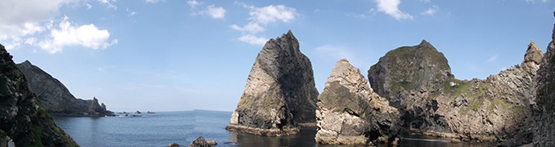
Where the rock climbing on Donegal’s coast line truly excels itself is in its sea stacks. There are a shade under 100 sea stacks with currently just over 150 recorded routes to their summits. The sea stacks are found along the coast of Donegal’s mainland and its western islands sit in some of the most remote, isolated and hostile coastal locations in Ireland. What these sea stacks provide is a large collection of the most adventurous, remote and atmospheric rock climbs in Ireland.
Sea stack climbing involves accessing huge towers of rock that stick out of the sea, it is this access that makes these locations so special. A day out on a sea stack will typically require a 250 meter descent to sea level to access an isolated storm beach, where it is highly unlikely anyone has ever stood before. This is followed by an UBER committing sea passage along the bases of currently unclimbed 250 meter high sea cliffs in a totally committed and potentially unescapable locations, this will allow you to gain the bases of the sea stacks. The commitment required and the sense of primal fear that accompanies these marine journeys has to experienced to be understood.
. As always, tad of logistics and planning is the key to success and of course the adoption of perhaps less orthodox climbing equipment such as 600m of 6mm polypro, a lightweight Lidl Dingy, a single lightweight paddle, divers booties, a 20ft Cordette, a pair of Speedo’s, heavy duty dry bags, 20m of 12mm polyprop, an alpine hammer, a snow bar, a selection of pegs, a chest harness/inverted Gri-Gri combo and a big Grin! We then climb these towers of rock to arrive on pristine pinpoint summits far from anywhere in the real world. Standing on a pinpoint summit over 100m above the ocean, 500m from the nearest point of land and 20KM from the nearest main road can easily be described as a truly spiritual experience.
Donegal Sea Stacks
Since 2007 I have been exploring the sea stacks of County Donegal, and have currently climbed over 60 previously unclimbed sea stacks along the coast of the county and recorded over 150 new routes on Donegal's Sea Stacks. During these adventures we have seen and experienced firsthand the true beauty of these little known places in coastal Ireland.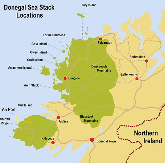
The main residence of the sea stacks is the Slievetooey coastline in the South West of the county, access to this coastline is by a narrow winding 20 km B road which takes you to the An Port road end.
An Staca sea stack
An Port is quite simply the most beautiful location in Ireland a trip to this road end is an outstanding journey in its own right, but it’s what lives either side of this road end that makes it a mind blowing location.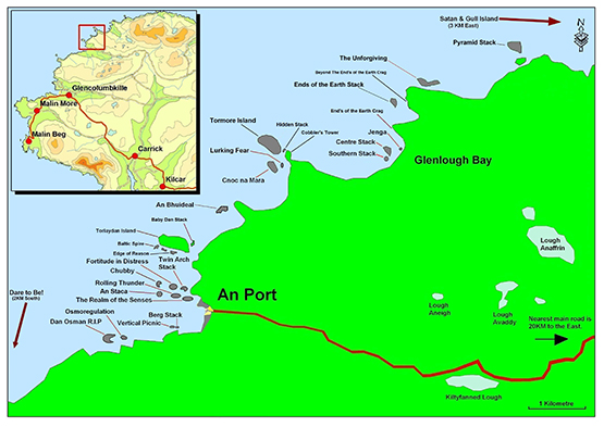 To the south of An Port lives a chain four sea stacks each with an increase in commitment and concern to reach their bases as they span further and further away from the remote storm beach launch pad facing Berg Stack. (link 4) To the South of these stacks the skyline is dominated by the Sturrall Headland, which provides an 750 meter rock climb which requires a 300 meter sea passage to reach its most sea ward tip. The rock climbing grade of this headland is given the little used XS grade as it means there is much more than rock climbing skills required for a safe ascent. Approx a third of the way up the ridge there is a 50 meter long section of climbing that will live forever in your memory!
An Port South
Travelling North from An Port the sea cliffs and sea stacks just get bigger and bigger. After about a 600 meter cliff top walk you will be overlooking the 90 meter high Toralaydan island. (Link 6) Living on its south and North sides are a further very difficult to access sea stacks. At the sea ward tip of its south side lives the Baltic Tower a route up its sea ward face provides a very scary climb called Icon, and at a very amenable climbing grade it provides a climb on immaculate rock in a terrifying nautical location.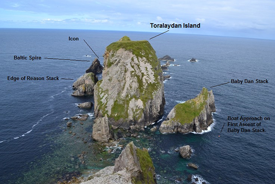
A further 500m to the North of Toralaydan Island lives An Bhuideal (The Bottle, as its north summit looks like a milk bottle when seen from the sea) an immaculate and iconic twin headed stack. There are currently three routes to its twin summits and all three are world class adventurous rock climbs. The super skinny North tower of this stack provides an unforgettable experience of three pitch climbing to its tiny and extremely exposed summit. The abseil descent from this micro summit involves a wee bit of prayer as the summit abseil anchors are a cairn of rocks and the landward face overhang alarmingly in its upper half. It is a very scary place to be! ☺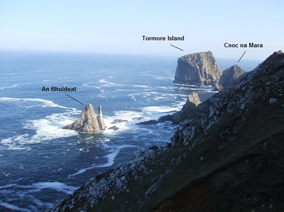
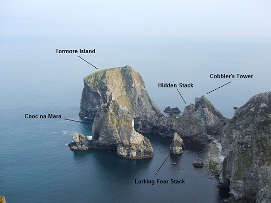
Travelling a further kilometre North along the coast from An Bhuideal takes you to a stunning cliff top viewpoint over looking Tormore Island, Irelands highest sea stack. Living in the shadow of Tormore Island is the 100 meter high Cnoc na Mara, it is difficult not to get emotional when talking about the mighty Cnoc na Mara.
Cnoc na mara Solo
Cnoc na Mara
When I first saw this 100m sea stack from the overlooking cliff tops it was the inspiration to climb every unclimbed sea stack in Donegal. It is safe to say this stack represents all that is great about adventure climbing. It's impressive soaring 150 meter long landward arete provides one of the most rewarding and adventurous rock climbs in Ireland. It is easily an equal to the mighty Old Man of Hoy off the Orkney Islands in the north of Scotland. Access is by a monsterous steep grassy descent followed by a 20 meter abseil to a storm beach at the entrance to Shambhala. As you descent this steep slope, sitting out to sea Cnoc na Mara grows with height as you descend reaching epic proportions as you get closer to the beach. Gaining the beach alone is an adventurous undertaking in its own right and is an excellent taster off what is to come. From the beach you paddle out for about 120 meter to the reach the base of the stack. The Landward arête of the stack is climbed in four pitches each pitch being much more atmospheric than the previous. The fourth pitch being the money shot as it is a 58 meter ridge traverse with 100 meters of air either side of you as you negotiate the short steep sections along this outstanding ridge traverse.
Gaining the summit is like being reborn into a world where anything is possible, it truly is a surreal and magical place to be. The whole world falls away below and around you, as you are perched on a summit far from anything else in the real world.
Paddle around Tormore Island
Tormore Island is a gigantic leviathan, a sentinel of the deep standing guard at the nautical gates of the Slievetooey coastline. At 150 meters above sea level at its highest point above the ocean it is Ireland's highest sea stack. This huge square topped sea stack can be seen for many kilometres along the coast either side of it. It can even be clearly seen from the Dungloe/Kincaslough road some 40 Kilometres to the north. Access is a very involved and emotional affair and entails gaining the storm beach as for Cnoc na Mara, Lurking Fear and Tormore Island. From here it is a 500 meter long sea passage around the headland to the north of the storm beach and a further 250 meter paddle through the outstanding channel separating Tormore Island and Cobblers Tower on the Donegal mainland. At the northern end of the land ward face of Tormore Island there is a huge non tidal ledge just above the high water mark.
In 2008 a team of four climbers travelled by 250 horse power RiB and landed on the land ward face of the stack. Two members of the party had made several previous attempts to land on and climb the stack in the past. We were aware of the story of the man who was buried here. During our climb of the stack we searched any possible place where someone could be buried and found no possible burial site or any trace of the passage of people on the stack prior to our ascent. We found no evidence or trace of previous visitors on the summit. To get off the summit back to sea level we made four 50 meter abseils leaving behind two 240 cm slings and 5 pitons as abseil anchors.
We climbed the very obvious land ward arete at the northern end of the land ward face of the sea stack, This huge feature can be easily seen from any position along the coast overlooking the stack. The route we took to the summit was climbed in 5 long pitches following the easiest climbing we could find up this huge feature.
To the North of the Tormore Island view point, the coastline falls away into Glenlough bay, a truly spectacular bay containing a further 4 sea stacks and Irelands largest raised shingle storm beach. On a day of huge north west sea motion the roar of a billions of tonnes of shingle being moved up and down the beach by the incoming seas can be deafening even from the cliff tops 200 meters above the beach.
To the north of Glenlough bay the land swings 90 degrees to face north and for a distance of 7 kilometres the sea cliffs increase to 300 meters high. At the base of these monster sea cliffs are a further four extremely inaccessible sea stacks, the 60 meters high Unforgiven Stack, the 50 meter high Pyramid Stack, the 80 meter high Satan and the 90 meter high Gull Island. Of these sea stacks Satan is the daddy, This sea stack is one of the most fearsome and dangerous stacks in Ireland. It sits off the north west face of the mighty Gull Island and presents considerable logistical and nautical access problems requiring a tad of nautical planning prior to attempting an ascent.
The most remote place in Ireland?
Access is by walking 4KM over the Slievetooey summit from the south and descending it's northern slopes to an outstanding location on the clifftops over looking Gull Island. Descend the very steep grass to the boulder beach joining Gull Island to the mainland. There is an abseil stake in place (2009) to safeguard the initial part of the descent. Once on the boulder beach paddle 500 or so meters west along the base of Gull Island to the entrance of a surreal gothic channel separating Satan and Gull Island. This channel is outrageous and leads you to the only landing place on the stack. Land on the stack at the convergance of the channels in the centre of this gothic labyrinth.
The stack was climbed in three pitches up it's south face culminating in a superb final pitch up a steep groove and rocky ridge traverse onto the majestic and super scary summit. The stack is so named as, if you make a mess of it the beast will take your soul.
Solo First Ascent
The Icon
Owey Island
Centre Stack
For more information click here to down load Iain Millers' free guidebook
Humpback Wows Whale Watchers With Breach Off Baltimore
#MarineWildlife - Whale Watch West Cork have shared this incredible video of one of a humpback whale breaching off Baltimore this week.
The whale is one of three of the ocean giants seen feeding off Baltimore and nearby islands in recent days, and caught in some stunning shots by photographer Simon Duggan, among others.
Meanwhile, some no less impressive sights have been seen of Donegal, new video shows basking sharks - the second biggest fish in the sea - breaching off Malin Head.
Bren Whelan of Wild Atlantic Way Climbing told Independent Travel that it's been an "outstanding week" for marine wildlife watching on the North Coast, saying he himself had witnessed "over 300" basking shark breaches.
Basking sharks have been seen in big numbers the area all month long, with 15 spotted during the Irish Whale and Dolphin Group's Whale Watch Ireland 2015 event on the afternoon of 23 August alone.
New Surfing Exchange Project For Cornish & Irish Teens
#Surfing - A new surfing exchange programme for young people is promoting cultural relations between the UK and Ireland.
As the Cornish Guardian reports, up to 15 local teenagers will be selected to take part in the Wave Project exchange with Co Donegal, which has the aim of boosting confidence and reducing anxiety through surfing.
The first exchange takes place over next month's half-term holidays in the UK, when 13 Irish youth will stay in Newquay.
They will return the favour next spring over the Easter break when the Cornish teens will stay at a purpose-built facility on the Donegal coast.
The Cornish Guardian has more on the story HERE.
Donegal Crab Boat Reports Near-Miss With Submarine
#Fishing - Donegal fishermen are counting their lucky stars after a near-miss with a submarine last week.
As TheJournal.ie reports, Seán Ó Briain says his crab boat came within just 200 metres of the sub, which appeared with little warning about 22km northwest of Tory Island last Thursday (3 September).
While the "general rule", according to Ó Briain, is to give right of way to fishing vessels such as his when setting or pulling pots, in this case "we needed to slow down to let the submarine pass".
Ó Briain added that daylight added to their luck both this time and in a similar incident this time last year, as they were able to take evasive action.
The story will bring to mind an Ardglass skipper's complaint that his prawn trawler was dragged backwards by a submarine in the Irish Sea this past April – an incident finally confirmed by the Royal Navy on Monday (7 September).
According to the Belfast Telegraph, Britain's Ministry of Defence admitted to the incident, which caused an estimated £10,000 worth of damage to Paul Murphy's boa and fishing gear, after "new information" came to light. More on the story HERE.
Whale Carcass Causes A Stink On Donegal Beach
#MarineWildlife - Locals near Magheraroarty Beach in Co Donegal were left with a smelly situation last week after the remains of a whale buried on the strand were washed back onto the surface in a matter of days.
According to The Irish Times, the sperm whale carcass was first found beached on Friday 19 June and buried under the sand where it was found by Donegal County Council over that weekend.
However, on Monday 22 June the cetacean carcass reappeared after it was washed back out from its burial place with the tide.
And in its more advanced decomposing state, the noxious odour was beginning to cause a stink among regular beach users and locals alike. The Irish Times has more on the story HERE.
Man Dies After Lobster Boat Incident Off Donegal

#Overboard - Breaking News reports that a man has died after falling overboard from a fishing vessel off Donegal this afternoon (Tuesday 16 June).
The deceased had been working on a lobster boat with a colleague off Horn Head when the incident occurred.
First on scene in the search and rescue operation was the Mulroy unit of the Irish Coast Guard, who recovered him from the water
He was then transferred to the Rescue 118 helicopter for airlift to Letterkenny General but was pronounced dead after arrival.


, and Dermot O’Kane, Head of Sales, Esri Ireland. Esri Ireland is announcing that its digital mapping system is helping DURL to prevent 13 million litres of polluted wastewater from entering Dublin rivers annually, by locating misconnected household appliances that are expelling polluted water")


 Michael Murphy Schull Harbour Sailing Club (SHSC), Eric Coogan Heineken Ireland, Mark Murphy, Commodore SHSC, Jack Allen SHSC, Carmel O'Regan SHSC, Cornelious Ndlovu, Schull Harbour Hotel Operations Manager and Derval Murphy SHSC")


