Menu

Ireland's sailing, boating & maritime magazine

Inland afloat headers


Displaying items by tag: Dublin Port

The Naval Service OPV L.E. Roisin (P51) will be open to the public this afternoon (2-4pm) at the North Wall Quay, opposite The National Convention Centre Dublin, which celebrated its first anniversary last month, writes Jehan Ashmore.
L.E. Roisin recently returned from Russia and she berthed for the first time at the North Wall Quay at berth 16A. Normally she would visit Dublin Port by berthing on the south-side banks of the River Liffey along Sir John Rogersons Quay, this applies to other vessel types when mooring within the Dublin 'Docklands'. As such it was most unusual to have a large vessel like L.E Roisin berthing opposite the impressive landmark venue.

It is only in recent years that larger vessels can berth at this stretch of the waterfront following the completion of several major construction projects over the last decade. From the building of the Convention Centre and the Samuel Beckett Bridge which involved using the dredger Hebble Sand (click HERE) during its construction process.

In addition the refurbishment of Spencer Dock sea-lock entrance that for many years was closed is now re-opened. The dock entrance featured in the start of the new television series 'Waterways'-The Royal Canal. Episode two is this Sunday on RTE 1 at 8.30pm.

Aside the 79m L.E. Roisin, the last large vessel to berth close to berth 16A was the French 58m tallship Belem, which was chartered by Alliance Francaise to celebrate their 50th anniversary in 2010 and for the inaugural French Hoist the Sail: Market Festival. The three-masted barque built in 1896 was once also owned by the Sir Arthur Ernest Guinness under the name of Fantôme II.

Situated between where L.E. Roisin is currently berthed and where the Belem had moored, is home to the 'resident' M.V. Cill Airne, a floating bar and restaurant dining venue at berth 16B. Another resident is the former lightship Kittiwake at berth 17B, though sited much further downstream at the end of North Wall Quay, opposite the O2 Arena and next to the East-Link Bridge.

There is a fourth resident, again berthed on the north quays, though the Jeanie Johnston unlike her counterparts is moored closer to the city-centre at Custom House Quay. Apart from yachts, leisure-craft and occasional private motor-yachts using the Dublin City Moorings, she is the only vessel to permanently occupy a berth between Samuel Beckett Bridge and the Sean O'Casey foot-bridge.

Published in Navy

An Taoiseach Enda Kenny visited the Marine Institute's research vessel RV Celtic Explorer in Dublin Port today, where he announced the creation of 92 jobs in the marine sector, writes Jehan Ashmore.

"Ireland is now recognised as an emerging power in Marine Research and Innovation," said the Taoiseach. Of the new positions, 64 will be generated in the seafood processing sector. This follows a €3.5m Seafood Processing Business Investment Scheme administered by Bord Iascaigh Mhara (BIM). In the area of marine research, 28 jobs have been created through funding of €2m from an International SmartOcean Graduate Programme.

SmartOcean is a collaboration between IRCSET (Irish Research Council for Science Engineering and Technology), the Marine Institute, five Irish universities and key multinationals and SME Information and Communication Technology (ICT) companies to provide funding for 28 research posts.

The Taoiseach said: "This has been achieved through the mapping of the 90% of Irish national territory that lies under the Atlantic, the creation of a quarter of a billion Euros worth of marine research infrastructure, and the fostering of strong linkages between industry and research centres, all of which will support employment opportunities in key areas of potential growth in the marine sector."

During the tour of the RV Celtic Explorer, the Taoiseach who was accompanied by Minister for Agriculture, Marine and Food, Simon Coveney, welcomed the expansion of Ireland's capabilities in the international shipping services sector, which is expected to attract additional jobs to the country.

Ireland's emerging international shipping services sector has continued to grow, underpinned by a number of investments in new and second hand ships over the last twelve months by such companies as Arklow Shipping and the Mainport Group, as well as foreign direct investments by D'Amico and Ardmore shipping.

As reported on Afloat.ie, RV Celtic Explorer had arrived yesterday into Dublin Port, having completed a fisheries demersal survey which started in Galway on 23 September. Initially she had docked at Ocean Pier but she subsequently shifted berths to Sir John Rogersons Quay for today's reception of An Taoiseach. According to her survey schedule she is due to depart tomorrow on a herring acoustic survey which is to take place in the Celtic Sea and off the south-west coast.

Published in Marine Science
Once again the Dublin Bay Old Gaffers Association's (DBOGA) winter talk programme, makes a welcome return to the Poolbeg Yacht and Boat Club, Ringsend, in the heart of Dublin Port.
During the winter / spring program which runs between October and March 2012, there will be five talks, leaving the month of April free for pre-season activities. The first talk is "The Last Leg" which is to be held next Wednesday (12th Oct) starting at 8pm and presented by Pat and Olivia Murphy. They will describe their compelling circumnavigation series with that 'last-leg' from Brisbane in Australia to Langkawi in Malaysia via The Great Barrier Reef, Darwin, Indonesia, and Singapore.

Please note that this inaugural talk of the season is on a Wednesday night which is a change from the normally scheduled Tuesday night, mostly starting at 8pm. Those wishing to attend may wish to arrive a bit earlier so to avail of the PYBC's clubhouse facilities, which overlooks its marina in the centre of Dublin Port, opposite Alexandra Basin.

The venue is located on the South Bank, Pigeon House Road, Ringsend which can be accessed from the Sean Moore Road that connects the Merrion Strand Road (from the south) and the East-Link Toll Bridge (from the north). For further information on the DBOGA lectures and more click HERE. In addition information about the PYBC Tel: (01) 668 9983 or logon to www.poolbegmarina.ie/

Published in Dublin Bay Old Gaffers
Those taking Sea Safari's Dublin Port & River Liffey tours will be able to see the inner workings of Ireland's largest port and from a totally different perspective, writes Jehan Ashmore.
The 45-minute tour sets out from beside the M.V. Cill Airne, in the heart of Dublin 'Docklands' and into the commercial port where over 17,000 vessel movements arrived and departed Dublin Port last year, accounting for 42% of the country's GDP and handling €20bn in exports per annum.

On board the open-topped yellow tour-boat RIB, an audio commentary firstly informs you about the M.V. Cill Airne, built nearby in the old Liffey Dockyard, nearly fifty year ago. Discover why she was one of the last riveted built vessels in Europe, her days as liner-tender and the rich and famous who threaded her decks.

Heading downstream the former lightship Kittiwake is berthed opposite the O2 Arena. She was one of the last lightships to serve in Irish waters at the South Rock station off Co. Down. In complete contrast a ferris-wheel revolves in the background but no sooner the boat slips under the East-Link Toll-Lift bridge which opened in 1984.

On the other side of the bridge a small non-descript looking grey-hulled motorboat lies at anchor, on her bow is painted the figure 11. So what's the story here!...here's a glue: 'Don't pay the ferry man until you get to the other side!...

Past Poolbeg Marina, giant blue-gantries cranes of the Marine Terminal Ltd (MTL) are busy unloading from Karin Schepers, a containership previously reported on Afloat.ie. Look out for the ports  'graffiti', the work of crews who make their mark by painting the name of their ship and also the mural of the late Ronnie Drew of The Dubliners.

Opposite this terminal is the ports largest basin, Alexandra Basin, named after Queen Alexandra. Subject to port security, the tour may include entering the basin should there be a particular vessel of note.This also allows for views of the dock-gates of the Dublin Graving Dock, one of only three large ship-repair facilities on the island of Ireland. Neighbouring the graving dock is where the Liffey Dockyard once stood.

Before the tour passes the towering twin stacks of the former ESB Poolbeg electricity power station is tucked away Pigeon Harbour. Learn more about its hotel conveniently sited beside where packet-ships regularly plied, essentially the ferryport of its day. Its modern-day counterpart faces opposite on the north quays where up to 17 sailings daily operate on the Irish Sea.

Marvel at the length of the impressive Great South Wall, why was it called 'Great' and why was it built?... What can be revealed is that Captain William Bligh of "Mutiny of the Bounty" fame was a major figure in the project, when the wall was completed in 1795.

The commentary has many more fascinating facts, figures and the occasional anecdote told with typical Dublin wit. So if you live within 80km (50-mile) radius of the capital, then the chances that the shirt you wear, the breakfast cereal you ate and the car you drive, most likely came through Dublin Port as almost 75% of goods serve this hinterland.

More on Dublin Bay here

Published in Dublin Port
28th September 2011

Fram From the Fjords and Beyond

Hurtigruten's polar expediton cruiseship Fram (2007/11,647grt) docked at the Cobh cruise terminal in Cork Harbour today, writes Jehan Ashmore.
The rather stout looking vessel which is 114m long on a beam of 20m was built in Italy to operate primarily as a cruiseship in artic waters. She differs to the rest of her fleetmates which operate Hurtigruten's coastal voyage along the fjords of Norway between Bergin to Kirkenes, near the Russian border.

Fram operates on cruises from Norway to Spitsbergen, Greenland, and Europe. She also cruises in Antarctic waters and explores the Chilean fjords. She can handle 400 passengers in 254 berths. On board there is a reception area, a large top-deck glass-enclosed observation salon positioned forward, bar, restaurant, library, shop and leisure facilities, including gym, sauna and jacuzzi. For further information and deck plans click HERE.

Throughout her interior she has traditional and modern artwork from a selection of Norwegian and Greenlandic artists. To read more on her Antarctic cruises and other destinations click HERE.

On this particular cruise, she had departed from Bergin and called to several Scottish ports prior to berthing in Belfast and docking in Dublin yesterday. This evening she heads for the Isles of Scilly, followed by a call to Portsmouth before disembarking her passengers in Hamburg.

Published in Cruise Liners
The Royal Navy's HMS Portland (F79) a 4,900 tonnes displacement Type 23 Duke –class frigate built as the last of fifteen such vessels a decade ago is on a weekend visit to Dublin Port, writes Jehan Ashmore.
Launched in 1999 at the shipyard of the then Marconi Marine at Scotstown on the Clyde, she then entered service two year later. During her contractor's sea trials she achieved a top speed of 30.8 knots and claims this as a record across the entire class.

She measures 133m (436ft) long and on a beam of 16.1m (52.9ft) and has a crew compliment of 185 in total. An array of highly sophisticated arnament is packed on board in addition she can convey a Lynx helicopter. Propulsion is derived from a combined use of diesel and gas (CODLAG) .To read more about the penultimate Type 23 class and her sisters click HERE

Published in Navy
Within hours of each other two ultra-luxurious vessels departed Dublin Port this morning, firstly the five star-rated cruiseship Hebridean Princess, and then followed the Bikini registered Cary Ali, a private charter mini-motoryacht, writes Jehan Ashmore.
Hebridean Princess, a former 600-passenger car-ferry, converted to carry only 50 guests, reached Carlingford around noon, where she is at anchor off the Co. Louth listed medieval heritage town. On the far side of Ulster, the cross-border waterway on Lough Foyle received two of three scheduled cruise-calls, but bad weather prevented Prisendem from anchoring off Greencastle in July.

As for Cary Ali, she is a 87ft long was built in 2007 by Nordhavn to a design of Jeff Leishman. From her stern flew the flag of the Marshal Islands in the Pacific Ocean. Inside the four-decked vessel there is the main salon, a dining room, galley and three guest staterooms, and a master cabin (click HERE). In total eight people can be accommodated. In addition she has a jacuzzi, fly-bridge and is equipped with a tender and has crew of four.

She has a speed of 24-knots and is equipped with 50hp bow and stern thrusters. To read more about the luxurious motoryacht including facts and figures click HERE.

The Cary Ali had berthed at the 100-berth marina of the Poolbeg Yacht & Boat Club which caters lesiure craft up to 20 metres and is centrally located on the south side of Dublin Port. The facility has accommodated larger motoryachts over the years. Though even larger motoryachts such as Battered Bull, a Feadship 52m has berthed further upriver at Dublin City Moorings.

Published in Cruise Liners
The World's smallest luxury cruiseship the Hebridean Princess, which in recent years was chartered to Queen Elizabeth II, docked in Dublin's docklands yesterday. She berthed on the south quays facing The Convention Centre, where a special event was hosted by the British Embassy on behalf of the monarch during her historic first state visit in May, writes Jehan Ashmore.
At only 2,112 tonnes and 70m long, the diminutive vessel berthed at Sir John Rogersons Quay last evening after picking up a pilot from the cutter Liffey in Dublin Bay. She had sailed overnight from Pembroke Dock and her call to the capital has allowed her passengers to spend a full day today touring attractions as she will remain moored again tonight before departing tomorrow.
Hebridean_Princess
Hebridean Princess berthed at Sir John Rogersons Quay. Photo Jehan Ashmore

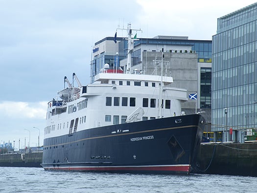
Operated by Hebridean Island Cruises, the 5-star vessel which is for only 50 guests, has a reputation for exceptional service, fine dining and has a crew of 38. Accommodation is in thirty spacious, elegant and well-appointed cabins. On Princess Deck is located 'The Isle of Arran' (for deck plans click HERE) Suite which at 340sq ft is the largest and most expensive. The suite comprises a large separate dayroom, a spacious bedroom and a luxuriously equipped Victorian-style marble bathroom. In addition 10 cabins are designed especially for the single traveller. She has appeared in 1st place in UltraTravel Magazine's "10 Coolest Cruises"

Normally the Glasgow registered vessel operates throughout the Scottish highlands and islands, to lochs and remote mainland locations made accessible due to her small size. It is in these same waters that the Hebridean Princess has sailed in another guise as the humble car-ferry Columba (photos) for Caledonian MacBrayne. She was built in 1964 by Hall Russell, Aberdeen and served in this role until 1989 when she was sold and underwent an extensive conversion for the ultra-luxury cruise market.

Her three-day stay to Dublin is part of a Grand Celtic Cruise which started in Cardiff and which will include a call to Carlingford Lough tomorrow, followed by Strangford Lough, Bangor, Ballycastle, the Scottish isles of Jura and Crinan before disembarking in Oban, her home-port. The 10-night cruise inclusive of three-gala dinners cost €4,195 per person for a double cabin and €6,292 per person in a single-cabin.

A decade before Columba was launched, the Royal Yacht Britannia (5,682 tonnes) was commissioned in 1954. She was laid-down two years previously at John Brown & Co. Ltd, Clydebank and the year before she entered service she was launched by HM Queen Elizabeth II. For over four decades she served as the royal yacht until decommissioned in 1997. Her final foreign mission was to convey the last governor of Hong Kong and Prince of Wales from the former colony after its handover to China. She is now permanently moored as an exhibition ship in Edinburgh (Leith) for details click HERE.

Earlier this month Queen Elizabeth's namesake the 2010 built Cunard Line cruiseship Queen Elizabeth made her maiden Irish call to Dublin followed by Cork (Cobh). To read more on Dublin call click HERE and for Cork (Cobh) click HERE.

Published in Cruise Liners
With the recent closure of Stena Line fast-ferry services from Dun Laoghaire and Rosslare, this leaves just four such services operating this winter between Ireland and Britain. By November only half of these services will be running on routes out of Dublin and Larne, writes Jehan Ashmore.
Currently three of these four services are employed on North Channel routes. P&O Ferries operate their fast-craft Express (1998/5,902 grt) on the one-hour route to Cairnryan which is also served by conventional ferry sisters that take two-hours. Since March the fast-ferry also joined the freight-ferry on the Troon route for the start of seasonal summer sailings which are to end on 3rd October.

The third service between Belfast-Stranraer is in the hands of rivals Stena Line which maintain the HSS Stena Voyager (1996/19,638 grt) on sailings but only to around mid-November. She will be replaced by conventional sister-ships which will be introduced on the North Channel's newest port when services switch from Stranraer to a new terminal close to Cairnryan.

Finally the fourth fast-ferry is Irish Ferries marketed 'Dublin Swift' service which runs on the Dublin-Holyhead route served by Jonathan Swift (1999/5,989 grt). The craft built by Austal in Fremantle, operates alongside the conventional cruise-ferry Ulysses.

Stena Line's decision to terminate HSS Stena Explorer sailings between Dun Laoghaire-Holyhead this day last week follows fast-ferry Stena Lynx III's end-of-season Rosslare-Fishguard sailings earlier this month.

From next year, Dun Laoghaire-Holyhead sailings are to be seasonal-only and according to Stena Line they hope to resume fast-ferry sailings in April or May though no exact date has been set. Unlike the central corridor route which was entirely dependent on HSS operations, the Rosslare-Fishguard route remains operating year-round with the conventional ferry Stena Europe.

As a result of the discontinued fast-ferries, the HSS Stena Explorer is now spending a lay-up period in the Welsh port for the winter. The smaller Stena Lynx III is also 'wintering' but in on the opposite side of the Irish Sea in Dun Laoghaire, where the vessel has done so in previous years.

The lay-up of both fast-ferries in Dun Laoghaire and Holyhead is ironic considering that neither ports' are connected by the very craft that used to share sailing rosters in recent years. In addition the wintering of these catamaran craft is the first time that this has occurred since the pioneering Stena Sea Lynx fast-ferry launched such sailings in 1993.

This first 'Lynx' provided seasonal sailings on the route with conventional car-ferry Stena Hibernia, the former St. Columba, custom-built in 1977 for Sealink /British Rail. She was given a second name under Stena ownership, the Stena Adventurer and remained on the 57 nautical-mile route until replaced in 1996 by the year-round operated HSS Stena Explorer.

Apart from cross-channel fast-ferry services, the Isle of Man is served by the Isle of Man Steam Packet Co. Ltd's routes linking the islands capital Douglas with Belfast, Dublin, Heysham and Liverpool (Birkenhead) in the winter. These routes include seasonal services which are operated by a combination of conventional tonnage using Ben-My-Chree and fast-ferry Manannan (1998/5,089grt), a former US Navy vessel, to read more click HERE. For sailing schedules, vessel type deployed on route and for fares click HERE.

Published in Ferry
With today's historic Irish rugby victory over Australia, fans of the green jersey, who happen to be on a cruise-ship with Cunard Line or P&O Cruises, will be able to continue watching games of the Rugby World Cup, writes Jehan Ashmore.
One of the ten participating cruise ships, Cunard Line's Queen Elizabeth (90,901 gross tonnes) owned by Carnival Corporation, made her maiden 'Irish' call to Dublin Port and Cobh last week, is showing live or recorded games within 24 hours from the original kick-off. This will enable games to be shown at convenient times for the participating cruise ships in their various locations.

A total of 24 matches are being shown, starting from the opening game and will include all four Home Nations' matches, quarter-finals, semi -finals, bronze final and then the final on 23rd October. Of course there will be other fans on board from Wales, Scotland, England and elsewhere watching the fixtures throughout the cruise-ships various sporting bars, pubs and other venues.

Carnival Corporation's UK entertainment services general manager, Paul Wright, said: "The Rugby World Cup is of great interest to many of our passengers and we're pleased that nobody will miss out by being on holiday with us throughout this time. At any one time we could have more than 19,000 passengers collectively on board and rooting for one of the Four Nations to bring home the trophy".

He added: "Most people have a sport that they follow and some times, like on a cruise ship, you won't have access to your favourite sport, which means a lot to fans. On our last cruise on Independence of the Seas, we had popular sports shown in state rooms and certain bars around the ship, of course football was the most common sport shown".

Incidentally Independence of the Seas has also called to Cobh since her Irish debut in 2007 and at 154,407 tonnes is the largest ever cruise-caller to Cork Harbour. She surpasses Cunard Line's flagship Queen Mary 2 of 148,528 tonnes which too berthed at Cobh last Wednesday, four days after Queen Elizabeth's inaugural visit.

Published in Cruise Liners
Page 49 of 59

General Information on using Waterways Ireland inland navigations

Safety on the Water

All users of the navigations are strongly recommended to make themselves aware of safety on the water for whatever activity they are involved in and to read the advice offered by the various governing bodies and by:

The Dept. of Transport, Ireland: www.gov.ie/transport and The Maritime and Coastguard Agency, UK, The RNLI – Water Safety Ireland for information in terms of drowning prevention and water safety.

Registration of Vessels

All vessels using the Shannon Navigation, which includes the Shannon-Erne Waterways and the Erne System must be registered with Waterways Ireland. Only open undecked boats with an engine of 15 horsepower or less on the Shannon Navigation, and vessels of 10 horsepower or less on the Erne System, are exempt. Registration is free of charge.

Craft registration should be completed online at: https://www.waterwaysireland.org/online-services/craft-registration

Permits for use of the Grand and Royal Canals and the Barrow Navigation

All vessels using the Grand and Royal Canals and the Barrow Navigation must display appropriate valid Permit(s) i.e A Combined Mooring and Passage Permit (€126) and if not intending to move every five days, an Extended Mooring Permit (€152).

Permit applications should be completed online at: https://www.waterwaysireland.org/online-services/canal-permits

Passage on the Royal and Grand Canals – Dublin Area

For boat passage through the locks east of Lock 12 into / out of Dublin on either the Royal or Grand Canals, Masters are requested to contact the Waterways Ireland Eastern Regional Office (M-F 9.30am-4.30pm) on tel: +353(0)1 868 0148 or email [email protected] prior to making passage in order to plan the necessary lock-keeping assistance arrangements.

On the Grand Canal a minimum of two days notice prior to the planned passage should be given, masters should note that with the exception of pre-arranged events, a maximum of 2 boats per day will be taken through the locks, travelling either east or west.

Movements in or out of the city will be organised by prior arrangement to take place as a single movement in one day. Boaters will be facilitated to travel the system if their passage is considered to be safe by Waterways Ireland and they have the valid permit(s) for mooring and passage.

Newcomen Lifting Bridge

On the Royal Canal two weeks’ notice of bridge passage (Newcomen Lifting Bridge) is required for the pre-set lift date, and lock assistance will then also be arranged. A minimum of 2 boats is required for a bridge lift to go ahead.

Waterways Ireland Eastern Regional Office (Tel: +353(0)1 868 0148 or [email protected] ) is the point of contact for the bridge lift.

A maximum number of boats passing will be implemented to keep to the times given above for the planned lifts (16 for the Sat / Sun lifts & 8 for the weekday lifts). Priority will be given on a first come first served basis.

On day of lift, boaters and passengers must follow guidance from Waterways Ireland staff about sequence of passage under bridge & through Lock 1, and must remain within signed and designated areas.

Events Held on the Waterways

All organised events taking place on the waterways must have the prior approval of Waterways Ireland. This is a twelve week process and application forms must be accompanied with the appropriate insurance, signed indemnity and risk assessment. The application should be completed on the Waterways Ireland events page at :

https://www.waterwaysireland.org/online-services/event-approval

Time Limits on Mooring in Public Harbours

On the Shannon Navigation and the Shannon-Erne Waterway craft may berth in public harbours for five consecutive days or a total of seven days in any one month.

On the Erne System, revised Bye Laws state that: No master or owner shall permit a vessel, boat or any floating or sunken object to remain moored at or in the vicinity of any public mooring, including mooring at any other public mooring within 3 kilometres of that location, for more than 3 consecutive days and shall not moor at that same mooring or any other public mooring within 3 kilometres of that location within the following 3 consecutive days without prior permission by an authorised official.

Winter Mooring on the Shannon Navigation and Shannon Erne Waterway

Winter mooring may be availed of by owners during the period 1 Nov to 31 Mar by prior arrangement and payment of a charge of €63.50 per craft. Craft not availing of Winter Mooring must continue to comply with the “5 Day Rule”. Winter Mooring applications should be completed online at : https://www.waterwaysireland.org/online-services/winter-moorings-booking

Owners should be aware that electricity supply and water supply to public moorings is disconnected for the winter months. This is to protect against frost damage, to reduce running costs and to minimise maintenance requirements during the winter months.

Vessel owners are advised that advance purchasing of electricity on the power bollards leading up to the disconnection date should be minimal. Electricity credit existing on the bollards will not be recoverable after the winter decommissioning date. Both services will be reinstated prior to the commencement of the next boating season.

Smart Cards

Waterways Ireland smart cards are used to operate locks on the Shannon Erne Waterway, to access the service blocks, to use the pump-outs along the navigations, to avail of electrical power at Waterways Ireland jetties.

Berthing in Public Harbours

Masters are reminded of the following:

  • Equip their vessel with mooring lines of appropriate length and strength and only secure their craft to mooring bollards and cleats provided for this purpose.
  • Ensure the available berth is suitable to the length of your vessel, do not overhang the mooring especially on finger moorings on floating pontoon moorings.
  • Ensure mooring lines, electric cables and fresh water hoses do not create a trip hazard on public jetties for others users.
  • Carry sufficient fenders to prevent damage to your own vessel, other vessels and WI property.
  • Allow sufficient space between your vessel and the vessel ahead /astern (c.1m) for fire safety purposes and /or to recover somebody from the water.
  • Do not berth more than two vessels side by side and ensure there is safe access/egress at all times between vessels and onto the harbour itself.
  • Do not berth in such a way to prevent use of harbour safety ladders, slipways or pump-outs.
  • Do not allow the bow of your vessel to overhang the walkway of a floating mooring thus creating a hazard for others with an overhanging anchor or bow fendering.
  • Animals are not allowed to be loose or stray at any time.
  • Harbour and jetty infrastructure such as railings, power pedestals, fresh water taps, electric light poles, safety bollards, ladders etc are not designed for the purpose of mooring craft , they will not bear the strain of a vessel and will be damaged.
  • At Carrybridge on the Erne System, Masters of vessels are not permitted to use stern on mooring. Masters of vessels must use the mooring fingers for mooring of vessels and for embarkation / disembarkation from vessels.

Passenger Vessel Berths

Masters of vessels should not berth on passenger vessel berths where it is indicated that an arrival is imminent. Passenger vessels plying the navigations generally only occupy the berths to embark and disembark passengers and rarely remain on the berths for extended periods or overnight.

Lock Lead-in Jetties

Lead-in jetties adjacent to the upstream and downstream gates at lock chambers are solely for the purpose of craft waiting to use the lock and should not be used for long term berthing.

Vessel Wake

Vessel wake, that is, the wave generated by the passage of the boat through the water, can sometimes be large, powerful and destructive depending on the hull shape and engine power of the vessel. This wake can be detrimental to other users of the navigation when it strikes their craft or inundates the shoreline or riverbank. Masters are requested to frequently look behind and check the effect of their wake / wash particularly when passing moored vessels, on entering harbours and approaching jetties and to be aware of people pursuing other activities such as fishing on the riverbank.

Speed Restriction

A vessel or boat shall not be navigated on the Shannon Navigation at a speed in excess of 5 kph when within 200 metres of a bridge, quay, jetty or wharf, when in a harbour or canal or when passing within 100 metres of a moored vessel or boat.

Vessels navigating the Shannon-Erne Waterway should observe the general 5 kph speed limit which applies along the waterway. This is necessary in order to prevent damage to the banks caused by excessive wash from vessels.

Vessels navigating the Erne System should observe the statutory 5kt / 6mph / 10kph speed limit areas.

A craft on the Royal and Grand canals shall not be navigated at a speed in excess of 6km per hour.

A craft on the Barrow Navigation shall not be navigated at a speed in excess of 11km per hour except as necessary for safe navigation in conditions of fast flow.

Bank Erosion

Narrow sections of all the navigations are particularly prone to bank erosion due to the large wash generated by some craft. Masters are requested to be vigilant and to slow down to a speed sufficient to maintain steerage when they observe the wash of their craft inundating the river banks.

Unusual Waterborne Activity

Unusual waterborne vessels may be encountered from time to time, such as, hovercraft or amphibious aircraft / seaplanes. Masters of such craft are reminded to apply the normal “Rule of the Road” when they meet conventional craft on the water and to allow extra room to manoeuvre in the interest of safety.

Sailing Activity

Mariners will encounter large numbers of sailing dinghies from late June to August in the vicinity of Lough Derg, Lough Ree and Lower Lough Erne. Sailing courses are marked by yellow buoys to suit weather conditions on the day. Vessels should proceed at slow speed and with due caution and observe the rules of navigation when passing these fleets, as many of the participants are junior sailors under training.

Rowing

Mariners should expect to meet canoes and vessels under oars on any part of the navigations, but more so in the vicinity of Athlone, Carrick-on-Shannon, Coleraine, Enniskillen and Limerick. Masters are reminded to proceed at slow speed and especially to reduce their wash to a minimum when passing these craft as they can be easily upset and swamped due to their very low freeboard and always be prepared to give way in any given traffic situation.

Canoeing

Canoeing is an adventure sport and participants are strongly recommended to seek the advice of the sport’s governing bodies i.e Canoeing Ireland and the Canoe Association of Northern Ireland, before venturing onto the navigations.

Persons in charge of canoes are reminded of the inherent danger to these craft associated with operating close to weirs, sluice gates, locks and other infrastructure particularly when rivers are in flood and large volumes of water are moving through the navigations due to general flood conditions or very heavy localised precipitation e.g. turbulent and broken water, stopper waves. Shooting weirs is prohibited without prior permission of Waterways Ireland.

Canoeists should check with lockkeepers prior entering a lock to ensure passage is done in a safe manner. Portage is required at all unmanned locks.

Canoe Trail Network – "Blueways"

Masters of powered craft are reminded that a canoe trail network is being developed across all navigations and to expect more organised canoeing along these trails necessitating slow speed and minimum wash when encountering canoeists, rowing boats etc

Rockingham and Drummans Island Canals – Lough Key

It is expected that work on Rockingham and Drummans Island Canals on Lough Key will be completed in 2021. Access to these canals will be for non-powered craft only, eg canoes, kayaks, rowing boats.

Fast Powerboats and Personal Watercraft (Jet Skis)

Masters of Fast Powerboats (speed greater than 17kts) and Personal Watercraft (i.e.Jet Skis) are reminded of the inherent dangers associated with high speed on the water and especially in the confines of small bays and narrow sections of the navigations. Keeping a proper look-out, making early alterations to course and /or reducing speed will avoid conflict with slower vessels using the navigation. Personal Watercraft are not permitted to be used on the canals.

Towing Waterskiers, Wakeboarders, Doughnuts etc

Masters of vessels engaged in any of these activities are reminded of the manoeuvring constraints imposed upon their vessel by the tow and of the added responsibilities that they have to the person(s) being towed. These activities should be conducted in areas which are clear of conflicting traffic. It is highly recommended that a person additional to the master be carried to act as a “look-out” to keep the tow under observation at all times.

Prohibition on Swimming

Swimming in the navigable channel, particularly at bridges, is dangerous and is prohibited due to the risk of being run over by a vessel underway in the navigation.

Age Restrictions on operating of powered craft

In the Republic of Ireland, Statutory Instrument 921 of 2005 provides the legal requirements regarding the minimum age for operating of powered craft. The Statutory Instrument contains the following requirements:

- The master or owner of a personal watercraft or a fast power craft shall take all reasonable steps to ensure that a person who has not attained the age of 16 years does not operate or control the craft

- The master or owner of a pleasure craft powered by an engine with a rating of more than 5 horse power or 3.7 kilowatts shall take all reasonable steps to ensure that a person who has not attained the age of 12 years does not operate or control the craft.

Lifejackets and Personal Flotation Devices (PFDs)

Lifejackets and PFD’s are the single most important items of personal protective equipment to be used on a vessel and should be worn especially when the vessel is being manoeuvred such as entering / departing a lock, anchoring, coming alongside or departing a jetty or quayside.

In the Republic of Ireland, Statutory Instrument 921 of 2005 provides the legal requirements regarding the wearing of Personal Flotation Devices. The Statutory Instrument contains the following requirements:

- The master or owner of a pleasure craft (other than a personal watercraft) shall ensure, that there are, at all times on board the craft, sufficient suitable personal flotation devices for each person on board.

- A person on a pleasure craft (other than a personal watercraft) of less than 7 metres length overall shall wear a suitable personal flotation device while on board an open craft or while on the deck of decked craft, other than when the craft is made fast to the shore or at anchor.

- The master or owner of a pleasure craft (other than a personal watercraft) shall take all reasonable steps to ensure that a person who has not attained the age of 16 years complies with paragraph above.

- The master or owner of a pleasure craft (other than a personal watercraft), shall take all reasonable steps to ensure that a person who has not attained the age of 16 years wears a suitable personal flotation device while on board an open craft or while on the deck of a decked craft other than when it is made fast to the shore or at anchor.

- The master or owner of a pleasure craft (other than a personal watercraft) shall take all reasonable steps to ensure that a person wears a suitable personal flotation device, at all times while – (a) being towed by the craft, (b) on board a vessel or object of any kind which is being towed by the craft.

Further information is available at: http://www.irishstatutebook.ie/eli/2005/si/921/made/en/print

Firing Range Danger Area – Lough Ree

The attention of mariners is drawn to the Irish Defence Forces Firing Range situated in the vicinity of buoys No’s 2 and 3, on Lough Ree on the Shannon Navigation. This range is used regularly for live firing exercises, throughout the year, all boats and vessels should stay clear of the area marked with yellow buoys showing a yellow "X" topmark and displaying the word "Danger".

Shannon Navigation, Portumna Swing Bridge Tolls

No attempt should be made by Masters’ of vessels to pay the bridge toll while making way through the bridge opening. Payment will only be taken by the Collector from Masters when they are secured alongside the jetties north and south of the bridge.

Navigating from Killaloe to Limerick on the Shannon Navigation

The navigation from Killaloe to Limerick involves passage through Ardnacrusha locks, the associated headrace and tailrace and the Abbey River into Limerick City. Careful passage planning is required to undertake this voyage. Considerations include: lock passage at Ardnacrusha, water flow in the navigation, airdraft under bridges on Abbey River in Limerick, state of tide in Limerick

Users are advised to contact the ESB Ardnacrusha hydroelectric power station (00353 (0)87 9970131) 48 hours in advance of commencing their journey to book passage through the locks at Ardnacrusha. It is NOT advised to undertake a voyage if more than one turbine is operating (20MW), due to the increased velocity of flow in the navigation channel, which can be dangerous. To ascertain automatically in real time how many turbines are running, users can phone +353 (0)87 6477229.

For safety reasons the ESB has advised that only powered craft with a capacity in excess of 5 knots are allowed to enter Ardnacrusha Headrace and Tailrace Canals.

Passage through Sarsfield Lock should be booked on +353-87-7972998, on the day prior to travel and it should be noted also that transit is not possible two hours either side of low water.

A Hydrographic survey in 2020 of the navigation channel revealed that the approach from Shannon Bridge to Sarsfield Lock and the Dock area has silted up. Masters of vessels and water users are advised to navigate to the Lock from Shannon bridge on a rising tide one or two hours before High Tide.

Lower Bann Navigation

The attention of all users is drawn to the “Users Code for the Lower Bann”, in particular to that section covering “Flow in the River” outlining the dangers for users both on the banks and in the navigation, associated with high flow rates when the river is in spate. Canoeists should consult and carry a copy of the “Lower Bann Canoe Trail” guide issued by the Canoe Association of Northern Ireland. Users should also contact the DfI Rivers Coleraine, who is responsible for regulating the flow rates on the river, for advisory information on the flow rates to be expected on any given day.

DfI Rivers Coleraine. Tel: 0044 28 7034 2357 Email: [email protected]

Lower Bann Navigation – Newferry – No wake zone

A No Wake Zone exists on the Lower Bann Navigation at Newferry. Masters of vessels are requested to proceed at a slow speed and create no wake while passing the jetties and slipways at Newferry.

Overhead Power Lines (OHPL) and Air draft

All Masters must be aware of the dangers associated with overhead power lines, in particular sailing vessels and workboats with cranes or large air drafts. Voyage planning is a necessity in order to identify the location of overhead lines crossing the navigation.

Overhead power line heights on the River Shannon are maintained at 12.6metres (40 feet) from Normal Summer level for that section of navigation, masters of vessels with a large air draft should proceed with caution and make additional allowances when water levels are high.

If a vessel or its equipment comes into contact with an OHPL the operator should NOT attempt to move the vessel or equipment. The conductor may still be alive or re-energise automatically. Maintain a safe distance and prevent third parties from approaching due to risk of arcing. Contact the emergency services for assistance.

Anglers are also reminded that a minimum ground distance of 30 metres should be maintained from overhead power lines when using a rod and line.

Submarine Cables and Pipes

Masters of vessels are reminded not to anchor their vessels in the vicinity of submarine cables or pipes in case they foul their anchor or damage the cables or pipes. Look to the river banks for signage indicating their presence.

Water Levels - Precautions

Low Water Levels:

When water levels fall below normal summer levels masters should be aware of:

Navigation

To reduce the risk of grounding masters should navigate on or near the centreline of the channel, avoid short cutting in dog-legged channels and navigating too close to navigation markers.

Proceeding at a slow speed will also reduce “squat” effect i.e. where the vessel tends to sit lower in the water as a consequence of higher speed.

Slipways

Reduced slipway length available under the water surface and the possibility of launching trailers dropping off the end of the concrete apron.

More slipway surface susceptible to weed growth requiring care while engaged in launching boats, from slipping and sliding on the slope. Note also that launching vehicles may not be able to get sufficient traction on the slipway once the craft is launched to get up the incline.

Bank Erosion

Very dry riverbanks are more susceptible to erosion from vessel wash.

Lock Share

Maximising on the number of vessels in a lock will ensure that the total volume of water moving downstream is decreased. Lock cycles should be used for vessels travelling each way.

High Water Levels:

When water levels rise above normal summer level masters should be aware of:

Navigation

Navigation marks will have reduced height above the water level or may disappear underwater altogether making the navigable channel difficult to discern.

In narrow sections of the navigations water levels will tend to rise more quickly than in main streams and air draft at bridges will likewise be reduced.

There will also be increased flow rates particularly in the vicinity of navigation infrastructure such as bridges, weirs, locks etc where extra care in manoeuvring vessels will be required.

Harbours and Jetties

Due care is required in harbours and at slipways when levels are at or near the same level as the harbour walkways' as the edge will be difficult to discern especially in reduced light conditions. It is advised that Personal Flotation Devices be worn if tending to craft in a harbour in these conditions.

Slipways

Slipways should only be used for the purpose of launching and recovering of water craft or other objects from the water. Before using a slipway it should be examined to ensure that the surface has sufficient traction/grip for the intended purpose such as launching a craft from a trailer using a vehicle, that there is sufficient depth of water on the slipway to float the craft off the trailer before the concrete apron ends and that the wheels of the trailer do not drop off the edge of the slipway. That life-saving appliances are available in the vicinity, that the vehicle is roadworthy and capable of coping with the weight of the trailer and boat on the incline. It is recommended that slipway operations are conducted by two persons.

Caution to be Used in Reliance upon Aids to Navigation

The aids to navigation depicted on the navigation guides comprise a system of fixed and floating aids to navigation. Prudent mariners will not rely solely on any single aid to navigation, particularly a floating aid to navigation. With respect to buoys, the buoy symbol is used to indicate the approximate position of the buoy body and the ground tackle which secures it to the lake or river bed. The approximate position is used because of the practical limitations in positioning and maintaining buoys in precise geographical locations. These limitations include, but are not limited to, prevailing atmospheric and lake/river conditions, the slope of and the material making up the lake/river bed, the fact that the buoys are moored to varying lengths of chain, and the fact that the buoy body and/or ground tackle positions are not under continuous surveillance. Due to the forces of nature, the position of the buoy body can be expected to shift inside and outside the charted symbol.

Buoys and perches are also moved out of position or pulled over by those mariners who use them to moor up to instead of anchoring. To this end, mariners should always monitor their passage by relating buoy/perch positions with the published navigation guide. Furthermore, a vessel attempting to pass close by always risks collision with a yawing buoy or with the obstruction that the buoy or beacon/perch marks.

Masters of Vessels are requested to use the most up to date Navigation guides when navigating on the Inland Waterways.

Information taken from Special Marine Notice No 1 of 2023