Menu

Ireland's sailing, boating & maritime magazine

Inland afloat headers


Displaying items by tag: Dun Laoghaire Harbour Company

Dublin Bay it set to burst alive with 'joie de vivre' during the only foreign stopover in the world-famous French Solitaire du Figaro yacht race.
Dun Laoghaire will be the only international stop in the race, considered the unofficial world offshore solo championshop, between 11 and 14 August.
To celebrate the visit of the iconic 3,390km race, Dun Laoghaire Rathdown County Council, the Dun Laoghaire Harbour Company and the National Yacht Club have joined forces to create the Festival des Bateaux.
The harbour will be a magnificent tapestry of colour as the boats arrive for this international event. Dun Laoghaire will be resplendent with fireworks, music and the sights, sounds, foods and ‘joie de vivre’ of France.
Fireworks will light up the sky at 10pm on Friday 12 August. There will also be a festival village with public access to visiting boats, a colourful and authentic French market and exhibition, a festival stage at Harbour Plaza and activities throughout Dun Laoghaire, not to mention a spectacular farewell as the boats depart early on Sunday 14 August.
Meanwhile, plans to berth the 45 or so competitors expected are well underway, according to the National Yacht Club.
Funding was secured between DLRCoCo and Fáilte Ireland, and the tender for the supply and delivery of 18x11.5m pontoons and associated service bollards was won by McNiven Marine, Irish agents for Ronautica Marine.
The gangway contract was secured by Tynes Gangway, and the last contract for the installation and de-commissioning of the infrastructure is currently underway.

Dublin Bay it set to burst alive with 'joie de vivre' during the only foreign stopover in the world-famous Solitaire du Figaro yacht race.

Dun Laoghaire will be the only international stop in the race, considered the unofficial world offshore solo championship, between 11 and 14 August.

To celebrate the visit of the iconic 3,390km race, Dun Laoghaire Rathdown County Council (dlrcoco), the Dun Laoghaire Harbour Company and the National Yacht Club have joined forces to create the Festival des Bateaux.

The harbour will be a magnificent tapestry of colour as the boats arrive for this international event. Dun Laoghaire will be resplendent with fireworks, music and the sights, sounds, foods and ‘joie de vivre’ of France.

Artist_Impression_Solitaire_stopover

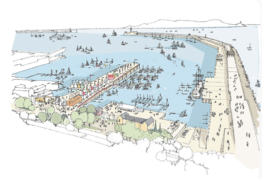
How Dun Laoghaire will look in August


Fireworks will light up the sky at 10pm on Friday 12 August. There will also be a festival village with public access to visiting boats, a colourful and authentic French market and exhibition, a festival stage at Harbour Plaza and activities throughout Dun Laoghaire, not to mention a spectacular farewell as the boats depart early on Sunday 14 August.

Meanwhile, plans to berth the 45 or so competitors expected are well underway, according to the National Yacht Club.

Funding was secured between dlrcoco and Fáilte Ireland, and the tender for the supply and delivery of 18x11.5m pontoons and associated service bollards was won by McNiven Marine, Irish agents for Ronautica Marine.

The gangway contract was secured by Tynes Gangway, and the last contract for the installation and de-commissioning of the infrastructure is currently underway.

Published in Figaro
With just over a fortnight to go to resumption of Stena Line's Dun Laoghaire-Holyhead fast-craft sailings on 1 April, the route to Wales is to see the larger HSS Stena Explorer return instead of Stena Lynx III, writes Jehan Ashmore.
It was originally planned that the 4,113grt 'Lynx' craft would start the season while the 19,638grt HSS (High Speed Service) fast-craft would take over in June for the summer months.

According to Stena Line over 70% of its passengers business is carried by the HSS Stena Explorer in the high season. It is felt that the 1996 Finnish built fast-craft is better suited for the service due to a loyal customer base which was reflected by repeat bookings and their preference of the HSS craft on the 120 minute (2 hour) route.

A daily single round trip is scheduled with sailings from Dun Laoghaire to Holyhead departing at 13:15hrs. The corresponding sailing from the Anglesey port departs at 10.00hrs and arrives at the Irish port at 12 noon. Sailings will operate through the summer until 13 September.

From there on Stena will make a decision as to its continuing schedule, though it is widely believed that the prospects of the fuel-thirsty, expensive to run HSS fast-craft service are likely to be at an end of an era.

Last month negotiations over the core issue of harbour fees were held between Stena Line and Dun Laoghaire Harbour Company. It is understood that the annual fee of €6.5m was dropped to €2m. The board of the harbour company has given a 'conditional green light' of a new ferry contract to Stena Line to run the service for the next two years with an option of a third year.

The service closed for its seasonal break earlier this year on 5 January with the 'Lynx' going into temporary lay-up at Holyhead's inner harbour to join the HSS Stena Explorer. The HSS had been 'wintering' at the port since September sailings were taken over by the Lynx.

Earlier this month the Stena Lynx III came to Dun Laoghaire to continue her lay-up period. The 1996 Tasmanian built craft will stay there before resuming seasonal sailings between Rosslare-Fishguard in tandem with the conventional ferry Stena Europe.

In the meantime the craft is berthed at the harbour's two-berth ferry terminal at St. Michaels Wharf. The HSS berth is only designed for this type of fast-craft whereas the other berth now occupied by the Lynx was built originally for conventional ferries but was re-configured last year to suit the fast-craft.

Published in Ferry
The Dun Laoghaire Harbour company has issued an invitation to tender for a new floating berth, despite being refused permission to continue development of the historic Carlisle Pier, The Sunday Business Post reports [link=http://www.thepost.ie/news/dun-laoghaire-harbour-to-get-pontoon-berth-54094.html].
Most of the listed structure was torn down in September 2009 and replaced with a car park by the company, which said it received legal advice that planning permission was not required.
Following a campaign by local residents and the intervention of Green Party TD Ciarán Cuffe and Dun Laoughaire Rathdown County Council, An Bord Pleanála ruled that the redevelopment was not exempted.
According to The Sunday Tribune [link=http://www.tribune.ie/news/article/2011/jan/23/historic-pier-structure-may-have-to-be-rebuilt/], the development plans were rejected on the basis of their effect on the local conservation area and failure to reuse elements of the old pier structures.
However, last week the company published a notice inviting tenders for a floating pontoon berth to be attached to the old pier, designed to accommodate cruise passengers.
The tender details are available to read online [link=http://www.etenders.gov.ie/search/show/search_view.aspx?ID=JAN194658], and the project is currently pending planning permission.
The harbour company is part of the Dun Laoghaire Cruise Stakeholder Group, which is marketing the town as a destination for international cruise liners.

The Dun Laoghaire Harbour company has issued an invitation to tender for a new floating berth, despite being refused permission to continue development of the historic Carlisle Pier, The Sunday Business Post reports.

Most of the listed structure was torn down in September 2009 and replaced with a car park by the company, which said it received legal advice that planning permission was not required.

Following a campaign by local residents and the intervention of Green Party TD Ciarán Cuffe and Dun Laoughaire Rathdown County Council, An Bord Pleanála ruled that the redevelopment was not exempted.

According to The Sunday Tribune, the development plans were rejected on the basis of their effect on the local conservation area and failure to reuse elements of the old pier structures.

However, last week the company published a notice inviting tenders for a floating pontoon berth to be attached to the old pier, designed to accommodate cruise passengers. 

The tender details are available to read online, and the project is currently pending planning permission.

The harbour company is part of the Dun Laoghaire Cruise Stakeholder Group, which is marketing the town as a destination for international cruise liners.

Published in News Update
The Dun Laoghaire Harbour Company has submitted a Business Case for the Construction and Operation of A Cruise Facility to the Government's E-Tender public procurement agency. Details of the request to tender can be viewed by clicking here.
The following stakeholders (listed below) are cooperating with a view to fast tracking the necessary constuction works for the development of the cruise terminal facility. The project envisages the largest 'next generation' of cruiseships will be able to dock within the harbour.

-Dun Laoghaire Rathdown County Council

-Dun Laoghaire Harbour Company

-Dun Laoghaire Chamber of Commerce

-Dun Laoghaire Business Association

and Dun Laoghaire Tourism interests.

Published in Cruise Liners

One of Dun Laoghaire's major international events next season, the visit of the French single-handed fleet, La Solitaire du Figaro, in August, will have a public festival running alongside say the National YC organisers. Dun Laoghaire Harbour Company and Dun Laoghaire Rathdown County Council are behind the festival.

Preparing for La Solitaire du Figaro here

Latest news for La Solitaire du Figaro here
Published in Figaro

The Dun Laoghaire Harbour Company has issued a brief statement regarding the decision of An Bord Pleanala on the demolition of structures on the Carlisle Pier last September. Afloat.ie reported that Ciaran Cuffe has called for the old Victorian structure on the pier to be rebuilt.

The Harbour Company published a brief statement on its website in response:

"The Dun Laoghaire Harbour Company is studying the initial report of An Bord Pleanala regarding the Carlisle Pier, and notes that it is the opinion of the Bord that the works, which occurred in early September 2009, did not involve Protected Structures or interfere with the setting of any Protected Structures. The Bord was of the view that the works required permission, and the structures constituted "Business Premises". The Harbour Company, in the light of the long disuse of the Pier, will study the report of the Bord's Inspector in detail and will then be in a position to make further comment.

Published in Dublin Bay

Green TD Ciaran Cuffe wants the Dun Laoghaire Harbour Company to rebuild the Victorian Railway building on Dun Laoghaire's Carlisle Pier. The structures on the Carlisle Pier were demolished in September of last year, and Deputy Cuffe reported the demolition to An Bord Pleanála in October, claiming that the demolition breached planning regulations and should have gone for approval. The Board ruled that the demolition of Carlisle Pier did not constitute 'exempted development' and therefore required planning permission. Cuffe has requested a meeting with the harbour company as soon as possible.

A statement on his website says:

“I welcome An Board Pleanála decision which holds that the Harbour Company were not authorised to demolish the pier in the manner in which they did.

“Few would shed any tears for the removal of the newer 1960s building on the pier but beneath it was an old Victorian Railway building that was a part of Dún Laoghaire's heritage.

“I think independent semi state companies should adhere to the highest planning standards. I am disappointed that the Dún Laoghaire Harbour Company demolished the building despite my writing to them stating that the demolition was illegal. They wiped away more than a century of our history and heritage, without asking the people of Dún Laoghaire for their opinion.

“I understand that much of the original building has been salvaged by the Dún Laoghaire Harbour Company. I hope that they will now restore the nineteenth century Railway Building that stood intact on the site concealed underneath the twentieth century building.”


Published in Dublin Bay
4th December 2009

Dun Laoghaire Harbour Company

Dun Laoghaire Harbour Company

headerphoto.jpg

The Dún Laoghaire Harbour Company is a state commercial company charged with the responsibility for the maintenance and development of Dún Laoghaire Harbour. It's corporate objectives are:

• To enhance Dún Laoghaire's attractiveness as a gateway for tourists to Ireland by offering state of the art berthing and terminal facilities to ferry operators at Dún Laoghaire Harbour

• To maintain and enhance the recreational and amenity value of the Harbour in the interest of all of its stakeholders

• To promote investment in the Harbour

• To generate sufficient cash flow from commercial operations to provide for the long term maintenance of the Harbour and meet the dividend targets of the Department of the Marine and Natural Resources

In order to carry out these objectives, the Company aims at all times, to be fair and equitable in its dealings with employees, suppliers and the local community. In addition it aims to provide and efficient and cost effective service to its customers

Market – Important Ferry Port linking East Coast of Ireland with Wales and the central corridor of the Irish Sea

Activities of the Company – To Manage and operate a Recreational and Commercial Harbour

Geographical Zone area – East Coast of Republic of Ireland

The Dún Laoghaire Harbour Board is appointed by the Minister of the Marine.

A map of the Harbour can be viewed here

Dun Laoghaire Harbour Company, Harbour Lodge, Crofton Road, Dún Laoghaire, Co Dublin, Ireland. Tel: +353 1 280 8681 • Fax: +353 1 280 8062

Harbour Master – Captain J P Carter, Ferry Terminal, Dun Laoghaire Harbour Company, Dun Laoghaire, Co. Dublin, Ireland. Tel: +353 1 280 1130 • Fax: +353 1 280 8062

Administration and Company Registered Address: Address as above. Tel: +353 1 280 1018/280 1311 • Fax: + 353 1 280 9607


Dun Laoghaire Harbour

Dun Laoghaire Harbour is located about six miles southeast of Dublin City Centre. It is located three minutes' walk from Dun Laoghaire town centre. The harbour itself was built between 1817 and 1842. It is possible to take a leisurely stroll along both the east and west piers of the harbour at any time. The East Pier is particularly popular among young and old alike in the summer months.

The Harbour is home to the Stena HSS ferry, which makes three return sailings each day between Dun Laoghaire and Holyhead in Wales. Each sailing takes only 99 minutes.

The HSS docks at a newly-opened terminal building, which includes a tourist office. 


A History of Dun Laoghaire Harbour

Dun Laoghaire is situated near Dublin in Ireland. It began as a small fishing village, but since the 19th Century, it has become part of the sprawling suburbs of our capital city. Despite this, it has managed to retain some of its individuality.

Dun Laoghaire is a very historical town. It used to be a small fishing village located on a rocky coast near Salthill, which was renowned for its production of salt. The original village, called Dunleary was situated near the beginning of the present West Pier. The present inner harbour, known as the coal harbour, dates from that time of the 18th Century. It consisted of 70 dwellings or cottages and was a very compact little village. All that remains of Dunleary is a row of 15 houses, including the Purty Kitchen (bar and restaurant) and the Coal Harbour Pier. However, during that time, there was also another pier which was in the form of a curve. That pier is now buried beneath the railway line. There used to be a sandy cove running up to the site of the former ‘Fun Factory’, which was closed recently. Now, all that land has been reclaimed and built on. In Dunleary during the 18th Century, there used to be a famous coffeehouse which was very popular with tourists and people on day-trips from Dublin. The small harbour used to dry-out at low tide but it was considered an important departure point for England. Dun Laoghaire is still an important port, however the present journey time of 1½ hours does not compare to the 22 hours then!

The death of Dunleary was started in the 1820s when the building of the harbour created a completely new town to the east, on the site of the present town. The first few buildings of the new town were constructed from the 1820s, although building of the harbour was started in 1815.

The harbour was only built to facilitate the trade in Dublin Port. At that time, the approaches to the Liffey were extremely dangerous. Many ships were grounded as there was only a narrow path through the sandbanks to the river mouth. It needed skilled captains to negotiate the dangers. Because of this, there was a huge waiting time. Ships were anchored out there for days before being allowed in. And, if that wasn’t enough for them, they had to brave fierce storms and gales that threatened to drive them onto the rocks.

So, it was decided that a place for the boats to stay was needed. Dunleary seemed a suitable place and the foundation stone was laid in 1817 by the Lord Lieutenant. King George IV visited Dunleary in 1821 causing the name ‘Kingstown’ to be formally adopted for the town. The visit of the King was recorded on the obelisk, which is now positioned in front of the Royal St. George Yacht Club.

The present name, Dun Laoghaire, was adopted again in 1920. This name was the Irish version of Dunleary meaning the fort of Laoghaire. In 1930, two small stones containing early decorations were dug up near the Coal Harbour, suggesting that the original fort was built there. This fort can’t be seen now, though, since a Martello Tower was built on top of it and then the construction of the railway destroyed them both. However, the National Museum said that the stones were of recent origin and that they were put there to prove that there was a dún in Dun Laoghaire. No one knows the truth.

The harbour consists of two huge granite piers. The East Pier is one mile long and the West Pier is even longer. It encloses a space of 250 acres and the two arms have protected ships in the most adverse of weather conditions except occasionally when northeasterly gales strike. It cost over one million pounds to build and more than 600 men were employed to construct it.

Dun Laoghaire was also an area for Martello Towers. These round towers were built under threat of an invasion by Napoleon in the early 1800s. Each one was built the same, and was positioned within firing distance of the next, along the East Coast from Skerries to Bray. On the top of each, there was a wall with a rail on top. The cannon sat on this rail and was free to point in any direction. Two Martello Towers were built in Dun Leary, one on the site of the supposed dún and one in the People’s Park. All have been destroyed. The original purpose of George’s Street, the main street of Dun Laoghaire, was to link the towers and the garrisons together.

The land in the centre of Dun Laoghaire was poor and partly used for grazing. Much of the land had been quarried with holes and stones on it covered with briars. The new town converted much of this to fine Georgian terraces, churches, yacht clubs and other public buildings.

The town grew between 1820 and 1840. George’s Street was quickly developed and also were the parallel streets Kingstown Parade, Rumley Avenue (now known as Patrick Street and Mulgrave Street) and Northumberland Avenue. The only building on Tivoli Road at that time was Carrig Castle, which was really a large house. The road itself was actually an old path between the castles of Bullock and Monkstown. During the 1830s, Granite Lodge, Primrose Hill, Tivoli Terrace, York Road, 2 schools and a Presbyterian Church were built. On the seafront, Crofton Terrace, Haddington Terrace, Victoria Terrace, Marine Terrace, Windsor Terrace and Martello Terrace were built. The forerunner of the Royal Marine Hotel, overlooking the harbour was built on Gresham Terrace.

The need for Dunleary to have a harbour of refuge from the tides and approaches of Dublin Bay finally saw some resolution in 1815 when the first stone was laid by Earl Whitworth the Lord Lieutenant of Ireland.

In all, the Harbour took nearly 40 years to complete and during this time 600 men were employed and the cost was estimated at one million pounds. The resulting Harbour enclosed a water area of some 250 acres. King George IV officially opened the Harbour in 1823 and Dunleary became Kingstown in his honour.

With the coming of the railway in the 1830’s Kingstown became a popular place to visit and to live in some of the lovely new terraces being built The Coal Harbour was an exceedingly busy place importing coal and in 1835 there were 20 registered yawls whose main trade was in importing coal from Swansea and Whitehaven in South Wales. By 1860, coal was the biggest business in the town and 1855 saw the Outer Coal Harbour constructed at a cost of £30,000, and in 1863 a railway siding was added in order to export pyrites from Avoca in Co. Wicklow to Wales and England. In 1859 the important Carlisle Pier was opened.

In 1827 the Harbour Commissioners had built a jetty to be used exclusively by the Admiralty’s Mail Packets. This Mail Service continued until 1850 when a new contract was made with the City of Dublin Steam Packet Company.

1861 saw the construction of a most attractive Lifeboat House on the Royal Slip at the foot of the Carlisle Pier. On Christmas Eve, 1895 while endeavouring to rescue the crew of the ‘Palme’ the lifeboat capsized with the loss of the entire fifteen man crew their names are recorded in a stone memorial.

A Harbour Master’s House was built in 1845. Twenty-five years earlier a stone house had been constructed for the Harbour Commissioners on Crofton Road with a commanding view of the Harbour this building was in latter years used as the residence of the Harbour Master.

A boom year for the area came in 1863 with the additions to the Harbour of a battery/fort, a coastguard station, a seaman’s home and a lighthouse and keepers cottages. An Anenometer to measure wind speed and direction was also part of the improvements. These buildings all show excellent workmanship.

For more than 170 years a Mailboat service has travelled between Dun Laoghaire and Holyhead in Wales. Even during World War I the Mailboat sailed. The ‘Leinster’ one of four boats plying the journey was torpeoded and sank 16 miles from Kingstown 501 died and 256 survived. The Mailboat continued uninterrupted service until the min 1970s. The new Car Fewrry Terminal was completed in 1969.

The Lifeboat still maintains an important and admirable service to all and presently a new Lifeboat Station is under construction.

The coal importation has ceased in Dun Laoghaire and the fishing industry has declined however an Ice House was built in 1972 on the Coal Harbour Quay and fresh fish can be purchased there by the general public.

In 1971 The World Fishing Championships were hosted by Dun Laoghaire and brought many visitors. Sailing is still an engrossing sport for many and is also enjoyed by many spectators during long summer evenings.

Article courtesy of www.spinaweb.ie/showcase/1156. St. Andrew's College Student Project

• Location: 11.2 kilometres southeast of Dublin on the southern shore of Dublin bay

• Water Area: Approximately 215 acres

• Fairway: Depth of 5.5 to 8 metres, with approximately 600 moorings

• When Built: Between 1817 and 1860

• Final Cost: Approximately IR£1,000,000

• Passenger Throughput: over 1,000,000 people per annum

• Breakwater Length: East Pier 1,290 metres - West Pier 1,548 metres

• Entrance Width: 232 metres (between the two piers)

• Yacht Clubs: 4

• Original Name: 'Dun Laoghaire Asylum Harbour' later renamed Dun Laoghaire under the State Harbours Act in 1924 

Published in Irish Ports
Page 6 of 6

General Information on using Waterways Ireland inland navigations

Safety on the Water

All users of the navigations are strongly recommended to make themselves aware of safety on the water for whatever activity they are involved in and to read the advice offered by the various governing bodies and by:

The Dept. of Transport, Ireland: www.gov.ie/transport and The Maritime and Coastguard Agency, UK, The RNLI – Water Safety Ireland for information in terms of drowning prevention and water safety.

Registration of Vessels

All vessels using the Shannon Navigation, which includes the Shannon-Erne Waterways and the Erne System must be registered with Waterways Ireland. Only open undecked boats with an engine of 15 horsepower or less on the Shannon Navigation, and vessels of 10 horsepower or less on the Erne System, are exempt. Registration is free of charge.

Craft registration should be completed online at: https://www.waterwaysireland.org/online-services/craft-registration

Permits for use of the Grand and Royal Canals and the Barrow Navigation

All vessels using the Grand and Royal Canals and the Barrow Navigation must display appropriate valid Permit(s) i.e A Combined Mooring and Passage Permit (€126) and if not intending to move every five days, an Extended Mooring Permit (€152).

Permit applications should be completed online at: https://www.waterwaysireland.org/online-services/canal-permits

Passage on the Royal and Grand Canals – Dublin Area

For boat passage through the locks east of Lock 12 into / out of Dublin on either the Royal or Grand Canals, Masters are requested to contact the Waterways Ireland Eastern Regional Office (M-F 9.30am-4.30pm) on tel: +353(0)1 868 0148 or email [email protected] prior to making passage in order to plan the necessary lock-keeping assistance arrangements.

On the Grand Canal a minimum of two days notice prior to the planned passage should be given, masters should note that with the exception of pre-arranged events, a maximum of 2 boats per day will be taken through the locks, travelling either east or west.

Movements in or out of the city will be organised by prior arrangement to take place as a single movement in one day. Boaters will be facilitated to travel the system if their passage is considered to be safe by Waterways Ireland and they have the valid permit(s) for mooring and passage.

Newcomen Lifting Bridge

On the Royal Canal two weeks’ notice of bridge passage (Newcomen Lifting Bridge) is required for the pre-set lift date, and lock assistance will then also be arranged. A minimum of 2 boats is required for a bridge lift to go ahead.

Waterways Ireland Eastern Regional Office (Tel: +353(0)1 868 0148 or [email protected] ) is the point of contact for the bridge lift.

A maximum number of boats passing will be implemented to keep to the times given above for the planned lifts (16 for the Sat / Sun lifts & 8 for the weekday lifts). Priority will be given on a first come first served basis.

On day of lift, boaters and passengers must follow guidance from Waterways Ireland staff about sequence of passage under bridge & through Lock 1, and must remain within signed and designated areas.

Events Held on the Waterways

All organised events taking place on the waterways must have the prior approval of Waterways Ireland. This is a twelve week process and application forms must be accompanied with the appropriate insurance, signed indemnity and risk assessment. The application should be completed on the Waterways Ireland events page at :

https://www.waterwaysireland.org/online-services/event-approval

Time Limits on Mooring in Public Harbours

On the Shannon Navigation and the Shannon-Erne Waterway craft may berth in public harbours for five consecutive days or a total of seven days in any one month.

On the Erne System, revised Bye Laws state that: No master or owner shall permit a vessel, boat or any floating or sunken object to remain moored at or in the vicinity of any public mooring, including mooring at any other public mooring within 3 kilometres of that location, for more than 3 consecutive days and shall not moor at that same mooring or any other public mooring within 3 kilometres of that location within the following 3 consecutive days without prior permission by an authorised official.

Winter Mooring on the Shannon Navigation and Shannon Erne Waterway

Winter mooring may be availed of by owners during the period 1 Nov to 31 Mar by prior arrangement and payment of a charge of €63.50 per craft. Craft not availing of Winter Mooring must continue to comply with the “5 Day Rule”. Winter Mooring applications should be completed online at : https://www.waterwaysireland.org/online-services/winter-moorings-booking

Owners should be aware that electricity supply and water supply to public moorings is disconnected for the winter months. This is to protect against frost damage, to reduce running costs and to minimise maintenance requirements during the winter months.

Vessel owners are advised that advance purchasing of electricity on the power bollards leading up to the disconnection date should be minimal. Electricity credit existing on the bollards will not be recoverable after the winter decommissioning date. Both services will be reinstated prior to the commencement of the next boating season.

Smart Cards

Waterways Ireland smart cards are used to operate locks on the Shannon Erne Waterway, to access the service blocks, to use the pump-outs along the navigations, to avail of electrical power at Waterways Ireland jetties.

Berthing in Public Harbours

Masters are reminded of the following:

  • Equip their vessel with mooring lines of appropriate length and strength and only secure their craft to mooring bollards and cleats provided for this purpose.
  • Ensure the available berth is suitable to the length of your vessel, do not overhang the mooring especially on finger moorings on floating pontoon moorings.
  • Ensure mooring lines, electric cables and fresh water hoses do not create a trip hazard on public jetties for others users.
  • Carry sufficient fenders to prevent damage to your own vessel, other vessels and WI property.
  • Allow sufficient space between your vessel and the vessel ahead /astern (c.1m) for fire safety purposes and /or to recover somebody from the water.
  • Do not berth more than two vessels side by side and ensure there is safe access/egress at all times between vessels and onto the harbour itself.
  • Do not berth in such a way to prevent use of harbour safety ladders, slipways or pump-outs.
  • Do not allow the bow of your vessel to overhang the walkway of a floating mooring thus creating a hazard for others with an overhanging anchor or bow fendering.
  • Animals are not allowed to be loose or stray at any time.
  • Harbour and jetty infrastructure such as railings, power pedestals, fresh water taps, electric light poles, safety bollards, ladders etc are not designed for the purpose of mooring craft , they will not bear the strain of a vessel and will be damaged.
  • At Carrybridge on the Erne System, Masters of vessels are not permitted to use stern on mooring. Masters of vessels must use the mooring fingers for mooring of vessels and for embarkation / disembarkation from vessels.

Passenger Vessel Berths

Masters of vessels should not berth on passenger vessel berths where it is indicated that an arrival is imminent. Passenger vessels plying the navigations generally only occupy the berths to embark and disembark passengers and rarely remain on the berths for extended periods or overnight.

Lock Lead-in Jetties

Lead-in jetties adjacent to the upstream and downstream gates at lock chambers are solely for the purpose of craft waiting to use the lock and should not be used for long term berthing.

Vessel Wake

Vessel wake, that is, the wave generated by the passage of the boat through the water, can sometimes be large, powerful and destructive depending on the hull shape and engine power of the vessel. This wake can be detrimental to other users of the navigation when it strikes their craft or inundates the shoreline or riverbank. Masters are requested to frequently look behind and check the effect of their wake / wash particularly when passing moored vessels, on entering harbours and approaching jetties and to be aware of people pursuing other activities such as fishing on the riverbank.

Speed Restriction

A vessel or boat shall not be navigated on the Shannon Navigation at a speed in excess of 5 kph when within 200 metres of a bridge, quay, jetty or wharf, when in a harbour or canal or when passing within 100 metres of a moored vessel or boat.

Vessels navigating the Shannon-Erne Waterway should observe the general 5 kph speed limit which applies along the waterway. This is necessary in order to prevent damage to the banks caused by excessive wash from vessels.

Vessels navigating the Erne System should observe the statutory 5kt / 6mph / 10kph speed limit areas.

A craft on the Royal and Grand canals shall not be navigated at a speed in excess of 6km per hour.

A craft on the Barrow Navigation shall not be navigated at a speed in excess of 11km per hour except as necessary for safe navigation in conditions of fast flow.

Bank Erosion

Narrow sections of all the navigations are particularly prone to bank erosion due to the large wash generated by some craft. Masters are requested to be vigilant and to slow down to a speed sufficient to maintain steerage when they observe the wash of their craft inundating the river banks.

Unusual Waterborne Activity

Unusual waterborne vessels may be encountered from time to time, such as, hovercraft or amphibious aircraft / seaplanes. Masters of such craft are reminded to apply the normal “Rule of the Road” when they meet conventional craft on the water and to allow extra room to manoeuvre in the interest of safety.

Sailing Activity

Mariners will encounter large numbers of sailing dinghies from late June to August in the vicinity of Lough Derg, Lough Ree and Lower Lough Erne. Sailing courses are marked by yellow buoys to suit weather conditions on the day. Vessels should proceed at slow speed and with due caution and observe the rules of navigation when passing these fleets, as many of the participants are junior sailors under training.

Rowing

Mariners should expect to meet canoes and vessels under oars on any part of the navigations, but more so in the vicinity of Athlone, Carrick-on-Shannon, Coleraine, Enniskillen and Limerick. Masters are reminded to proceed at slow speed and especially to reduce their wash to a minimum when passing these craft as they can be easily upset and swamped due to their very low freeboard and always be prepared to give way in any given traffic situation.

Canoeing

Canoeing is an adventure sport and participants are strongly recommended to seek the advice of the sport’s governing bodies i.e Canoeing Ireland and the Canoe Association of Northern Ireland, before venturing onto the navigations.

Persons in charge of canoes are reminded of the inherent danger to these craft associated with operating close to weirs, sluice gates, locks and other infrastructure particularly when rivers are in flood and large volumes of water are moving through the navigations due to general flood conditions or very heavy localised precipitation e.g. turbulent and broken water, stopper waves. Shooting weirs is prohibited without prior permission of Waterways Ireland.

Canoeists should check with lockkeepers prior entering a lock to ensure passage is done in a safe manner. Portage is required at all unmanned locks.

Canoe Trail Network – "Blueways"

Masters of powered craft are reminded that a canoe trail network is being developed across all navigations and to expect more organised canoeing along these trails necessitating slow speed and minimum wash when encountering canoeists, rowing boats etc

Rockingham and Drummans Island Canals – Lough Key

It is expected that work on Rockingham and Drummans Island Canals on Lough Key will be completed in 2021. Access to these canals will be for non-powered craft only, eg canoes, kayaks, rowing boats.

Fast Powerboats and Personal Watercraft (Jet Skis)

Masters of Fast Powerboats (speed greater than 17kts) and Personal Watercraft (i.e.Jet Skis) are reminded of the inherent dangers associated with high speed on the water and especially in the confines of small bays and narrow sections of the navigations. Keeping a proper look-out, making early alterations to course and /or reducing speed will avoid conflict with slower vessels using the navigation. Personal Watercraft are not permitted to be used on the canals.

Towing Waterskiers, Wakeboarders, Doughnuts etc

Masters of vessels engaged in any of these activities are reminded of the manoeuvring constraints imposed upon their vessel by the tow and of the added responsibilities that they have to the person(s) being towed. These activities should be conducted in areas which are clear of conflicting traffic. It is highly recommended that a person additional to the master be carried to act as a “look-out” to keep the tow under observation at all times.

Prohibition on Swimming

Swimming in the navigable channel, particularly at bridges, is dangerous and is prohibited due to the risk of being run over by a vessel underway in the navigation.

Age Restrictions on operating of powered craft

In the Republic of Ireland, Statutory Instrument 921 of 2005 provides the legal requirements regarding the minimum age for operating of powered craft. The Statutory Instrument contains the following requirements:

- The master or owner of a personal watercraft or a fast power craft shall take all reasonable steps to ensure that a person who has not attained the age of 16 years does not operate or control the craft

- The master or owner of a pleasure craft powered by an engine with a rating of more than 5 horse power or 3.7 kilowatts shall take all reasonable steps to ensure that a person who has not attained the age of 12 years does not operate or control the craft.

Lifejackets and Personal Flotation Devices (PFDs)

Lifejackets and PFD’s are the single most important items of personal protective equipment to be used on a vessel and should be worn especially when the vessel is being manoeuvred such as entering / departing a lock, anchoring, coming alongside or departing a jetty or quayside.

In the Republic of Ireland, Statutory Instrument 921 of 2005 provides the legal requirements regarding the wearing of Personal Flotation Devices. The Statutory Instrument contains the following requirements:

- The master or owner of a pleasure craft (other than a personal watercraft) shall ensure, that there are, at all times on board the craft, sufficient suitable personal flotation devices for each person on board.

- A person on a pleasure craft (other than a personal watercraft) of less than 7 metres length overall shall wear a suitable personal flotation device while on board an open craft or while on the deck of decked craft, other than when the craft is made fast to the shore or at anchor.

- The master or owner of a pleasure craft (other than a personal watercraft) shall take all reasonable steps to ensure that a person who has not attained the age of 16 years complies with paragraph above.

- The master or owner of a pleasure craft (other than a personal watercraft), shall take all reasonable steps to ensure that a person who has not attained the age of 16 years wears a suitable personal flotation device while on board an open craft or while on the deck of a decked craft other than when it is made fast to the shore or at anchor.

- The master or owner of a pleasure craft (other than a personal watercraft) shall take all reasonable steps to ensure that a person wears a suitable personal flotation device, at all times while – (a) being towed by the craft, (b) on board a vessel or object of any kind which is being towed by the craft.

Further information is available at: http://www.irishstatutebook.ie/eli/2005/si/921/made/en/print

Firing Range Danger Area – Lough Ree

The attention of mariners is drawn to the Irish Defence Forces Firing Range situated in the vicinity of buoys No’s 2 and 3, on Lough Ree on the Shannon Navigation. This range is used regularly for live firing exercises, throughout the year, all boats and vessels should stay clear of the area marked with yellow buoys showing a yellow "X" topmark and displaying the word "Danger".

Shannon Navigation, Portumna Swing Bridge Tolls

No attempt should be made by Masters’ of vessels to pay the bridge toll while making way through the bridge opening. Payment will only be taken by the Collector from Masters when they are secured alongside the jetties north and south of the bridge.

Navigating from Killaloe to Limerick on the Shannon Navigation

The navigation from Killaloe to Limerick involves passage through Ardnacrusha locks, the associated headrace and tailrace and the Abbey River into Limerick City. Careful passage planning is required to undertake this voyage. Considerations include: lock passage at Ardnacrusha, water flow in the navigation, airdraft under bridges on Abbey River in Limerick, state of tide in Limerick

Users are advised to contact the ESB Ardnacrusha hydroelectric power station (00353 (0)87 9970131) 48 hours in advance of commencing their journey to book passage through the locks at Ardnacrusha. It is NOT advised to undertake a voyage if more than one turbine is operating (20MW), due to the increased velocity of flow in the navigation channel, which can be dangerous. To ascertain automatically in real time how many turbines are running, users can phone +353 (0)87 6477229.

For safety reasons the ESB has advised that only powered craft with a capacity in excess of 5 knots are allowed to enter Ardnacrusha Headrace and Tailrace Canals.

Passage through Sarsfield Lock should be booked on +353-87-7972998, on the day prior to travel and it should be noted also that transit is not possible two hours either side of low water.

A Hydrographic survey in 2020 of the navigation channel revealed that the approach from Shannon Bridge to Sarsfield Lock and the Dock area has silted up. Masters of vessels and water users are advised to navigate to the Lock from Shannon bridge on a rising tide one or two hours before High Tide.

Lower Bann Navigation

The attention of all users is drawn to the “Users Code for the Lower Bann”, in particular to that section covering “Flow in the River” outlining the dangers for users both on the banks and in the navigation, associated with high flow rates when the river is in spate. Canoeists should consult and carry a copy of the “Lower Bann Canoe Trail” guide issued by the Canoe Association of Northern Ireland. Users should also contact the DfI Rivers Coleraine, who is responsible for regulating the flow rates on the river, for advisory information on the flow rates to be expected on any given day.

DfI Rivers Coleraine. Tel: 0044 28 7034 2357 Email: [email protected]

Lower Bann Navigation – Newferry – No wake zone

A No Wake Zone exists on the Lower Bann Navigation at Newferry. Masters of vessels are requested to proceed at a slow speed and create no wake while passing the jetties and slipways at Newferry.

Overhead Power Lines (OHPL) and Air draft

All Masters must be aware of the dangers associated with overhead power lines, in particular sailing vessels and workboats with cranes or large air drafts. Voyage planning is a necessity in order to identify the location of overhead lines crossing the navigation.

Overhead power line heights on the River Shannon are maintained at 12.6metres (40 feet) from Normal Summer level for that section of navigation, masters of vessels with a large air draft should proceed with caution and make additional allowances when water levels are high.

If a vessel or its equipment comes into contact with an OHPL the operator should NOT attempt to move the vessel or equipment. The conductor may still be alive or re-energise automatically. Maintain a safe distance and prevent third parties from approaching due to risk of arcing. Contact the emergency services for assistance.

Anglers are also reminded that a minimum ground distance of 30 metres should be maintained from overhead power lines when using a rod and line.

Submarine Cables and Pipes

Masters of vessels are reminded not to anchor their vessels in the vicinity of submarine cables or pipes in case they foul their anchor or damage the cables or pipes. Look to the river banks for signage indicating their presence.

Water Levels - Precautions

Low Water Levels:

When water levels fall below normal summer levels masters should be aware of:

Navigation

To reduce the risk of grounding masters should navigate on or near the centreline of the channel, avoid short cutting in dog-legged channels and navigating too close to navigation markers.

Proceeding at a slow speed will also reduce “squat” effect i.e. where the vessel tends to sit lower in the water as a consequence of higher speed.

Slipways

Reduced slipway length available under the water surface and the possibility of launching trailers dropping off the end of the concrete apron.

More slipway surface susceptible to weed growth requiring care while engaged in launching boats, from slipping and sliding on the slope. Note also that launching vehicles may not be able to get sufficient traction on the slipway once the craft is launched to get up the incline.

Bank Erosion

Very dry riverbanks are more susceptible to erosion from vessel wash.

Lock Share

Maximising on the number of vessels in a lock will ensure that the total volume of water moving downstream is decreased. Lock cycles should be used for vessels travelling each way.

High Water Levels:

When water levels rise above normal summer level masters should be aware of:

Navigation

Navigation marks will have reduced height above the water level or may disappear underwater altogether making the navigable channel difficult to discern.

In narrow sections of the navigations water levels will tend to rise more quickly than in main streams and air draft at bridges will likewise be reduced.

There will also be increased flow rates particularly in the vicinity of navigation infrastructure such as bridges, weirs, locks etc where extra care in manoeuvring vessels will be required.

Harbours and Jetties

Due care is required in harbours and at slipways when levels are at or near the same level as the harbour walkways' as the edge will be difficult to discern especially in reduced light conditions. It is advised that Personal Flotation Devices be worn if tending to craft in a harbour in these conditions.

Slipways

Slipways should only be used for the purpose of launching and recovering of water craft or other objects from the water. Before using a slipway it should be examined to ensure that the surface has sufficient traction/grip for the intended purpose such as launching a craft from a trailer using a vehicle, that there is sufficient depth of water on the slipway to float the craft off the trailer before the concrete apron ends and that the wheels of the trailer do not drop off the edge of the slipway. That life-saving appliances are available in the vicinity, that the vehicle is roadworthy and capable of coping with the weight of the trailer and boat on the incline. It is recommended that slipway operations are conducted by two persons.

Caution to be Used in Reliance upon Aids to Navigation

The aids to navigation depicted on the navigation guides comprise a system of fixed and floating aids to navigation. Prudent mariners will not rely solely on any single aid to navigation, particularly a floating aid to navigation. With respect to buoys, the buoy symbol is used to indicate the approximate position of the buoy body and the ground tackle which secures it to the lake or river bed. The approximate position is used because of the practical limitations in positioning and maintaining buoys in precise geographical locations. These limitations include, but are not limited to, prevailing atmospheric and lake/river conditions, the slope of and the material making up the lake/river bed, the fact that the buoys are moored to varying lengths of chain, and the fact that the buoy body and/or ground tackle positions are not under continuous surveillance. Due to the forces of nature, the position of the buoy body can be expected to shift inside and outside the charted symbol.

Buoys and perches are also moved out of position or pulled over by those mariners who use them to moor up to instead of anchoring. To this end, mariners should always monitor their passage by relating buoy/perch positions with the published navigation guide. Furthermore, a vessel attempting to pass close by always risks collision with a yawing buoy or with the obstruction that the buoy or beacon/perch marks.

Masters of Vessels are requested to use the most up to date Navigation guides when navigating on the Inland Waterways.

Information taken from Special Marine Notice No 1 of 2023