


Displaying items by tag: Dunmore East
Dunmore East Lifeboat Assists Fishing Vessel Taking On Water
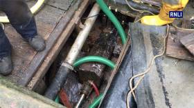
#RNLI - Dunmore East RNLI launched this past Wednesday afternoon (25 October) to assist a fishing vessel that was taking on water.
The two crew of the 25ft vessel were coming into the Co Waterford harbour before 2.50pm when they realised there was an ingress of water below deck.
Quick thinking by the lifeboat crew, who grabbed their salvage pump to assist, meant the vessel was able to stay afloat.
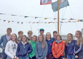
The 420 Munster Championships were held at Waterford Harbour Sailing Club in Dunmore East last weekend in conjunction with the South Coast Championships of the Flying Fifteens (report here)
The sailors enjoyed an excellent weekend of racing that started in bright sunshine with a breeze of 15-20–knots that moderated as the racing progressed.
Four races were completed on the Saturday with Geoff Power and James McCann winning all four races. The top dinghy pair previously finished in pair in the top ten at 420 Kiel Week Regatta in June.
Sunday's racing provided a contrast in weather with a constant drizzle and a switch in wind direction bringing a large swell into Dunmore East to add further excitement to the downwind legs with plenty of surfing in evidence. The speed of the 420 crews around the course, both upwind and downwind, provided an exciting spectacle for those watching from the harbour wall. Two races were completed on Sunday with Geoff Power and James McCann completing a perfect series in the Gold fleet by also winning the final two races.
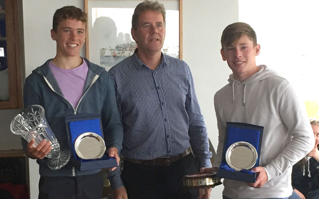 Geoff Power and James McCann collect their trophies at WHSC
Silver fleet was won by Sarah Levie and Emily Whitaker.
The results of the Gold and Silver fleets are as follows:
Gold Fleet
1st Geoff Power WHSC/ James Mc Cann RCYC
2nd Gemma Mc Dowell/Emma Gallagher MYC
3rd Nicola Ferguson. Fiona Ferguson NYC
Silver Fleet
1st Sarah Levie LRYC/ Emily Whitaker RCYC
2nd Lucy Bell SLYC/Emma Greer SLYC
3rd Dara Donnelly / Cliona Coyle NYC
Full results sheet is downloadable below
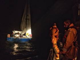
Fethard RNLI Rescues Two People After Yacht Runs Aground off Wexford Coast
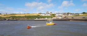
Fethard RNLI rescued two people after their yacht ran aground off the Wexford coast yesterday evening.
The volunteer lifeboat crew was requested to launch their inshore lifeboat shortly after 5pm following a report from the Irish Coast Guard that a vessel with two people onboard had got into difficulty.
The 27ft yacht had run aground on a mudbank in Duncannon Harbour.
The lifeboat launched at 5.27pm and was on scene at 5.30pm. Dunmore East RNLI’s all-weather lifeboat was also launched.
Weather conditions at the time were good with a south west Force 5 wind and moderate seas.
Having assessed that the two people onboard were safe and well, the lifeboat crew proceeded to work with them to establish a tow line at the back of the yacht. However, this set up proved challenging and it was decided to tow the vessel from the front.
The yacht was successfully re-floated by Fethard’s lifeboat while Dunmore East’s all-weather lifeboat stood by in the event more power was required.
The yacht then safely continued on her own to Dunmore East.
Speaking following the call out, Hugh Burke, Fethard RNLI Deputy Launching Authority said: ‘As we continue to enjoy the summer, we would remind anyone planning a trip at sea to go prepared and respect the water. Communications is vital and it is important that you always carry a means of calling or signalling for help should you get into difficulty and need to contact the emergency services. If you do find yourself in trouble or see someone else in difficulty call 999 or 112 and ask for the Coast Guard.’
Divers Rescued Off Hook Head By Dunmore East Lifeboat
#RNLI - Dunmore East RNLI rescued two divers who got into difficulty off Hook Head in Co Wexford on Sunday afternoon (28 May).
The volunteer crew were requested to launch their all-weather lifeboat at 1.19pm following a report from the Irish Coast Guard that two divers were in the sea and holding on to a buoy off Hook Head.
The two men had been doing a shore dive when they drifted offshore in tidal conditions.
Launching under coxswain Michael Griffin with four crew members onboard, the lifeboat was on the water within minutes. The Irish Coast Guard helicopter Rescue 117 from Waterford was also tasked.
Weather conditions at the time were good as the lifeboat made its way to the location around half a nautical mile from Hook Head.
On scene, the lifeboat crew observed orange smoke deployed by the helicopter overhead to guide the crew to where the divers had been located.
The divers, who were thought to be in the water for some 30 minutes, were assessed with one showing early signs of hypothermia.
Casualty care was administered on the lifeboat and the two divers were transferred safely back to shore at Slade Harbour, where they were made comfortable and not found to require any further medical attention.
Speaking following the callout, Dunmore East RNLI volunteer lifeboat press officer Neville Murphy said: “We were happy to help the divers and would like to wish them both a speedy recovery.
“As we approach the summer months, we would remind anyone planning any activity at sea to respect the water. Always wear the appropriate clothing for your activity and always wear a personal floatation device.
“Check the weather and tide times before you venture out and remember to always carry a means of calling for help and tell someone else where you are going and when you are due back.”
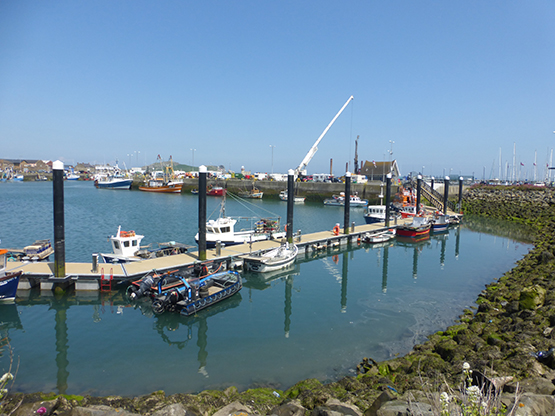
Open Water Swim For Dunmore East Lifeboat This Month
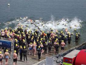
#Swimming - This year’s Dunmore East RNLI Open Water Swim sponsored by Activate and Lidl will take place on Saturday 20 May.
Entry is €25 for any of three swims over distances of 1600m, 800m and a junior swim of 500m, starting at 12.30pm from the slip behind Waterford Harbour Sailing Club in Dunmore East.
“We had such a successful event last we are really looking forward to this year’s event,” said Dunmore East RNLI lifeboat crew member Neville Murphy.
“We live in one of the most beautiful parts of the country with a stunning coastline, and it is the perfect location for this type of event.
“Let’s hope the weather is as good as last year and we have as many participants, which in turn will help us raise funds for the RNLI and their lifesaving work.”
This year’s event promised a fun-filled family atmosphere with balloon making, face painting and much more children’s entertainment, and a BBQ for swimmers and their supporters alike.
All prizegiving will take place at the newly refurbished Waterford Harbour Sailing Club after the completion of all three swims, with music entertainment will be provided by DJ Frankie McAvoy.
For more information about the Dunmore East RNLI Open Water Swim and to register online, go to www.athleticstiming.com.
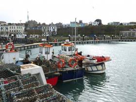
Ireland’s Six Fishery Harbour Centres & Small Harbours Get €28m In Funding For Capital Projects
The Minister for Agriculture, Food and the Marine, Michael Creed TD, today announced details of a €28m Capital Investment Package for the ongoing development of Ireland’s Local Authority owned small harbour network. (see Table 1 below for details)
In announcing the initiative the Minister said “The €28m I am allocating for the 2017 Fishery Harbour and Coastal Infrastructure Capital Programme represents a significantly increased capital investment in the six Fishery Harbour Centres and other fisheries related marine infrastructure. It is testament not only to this Governments ongoing commitment to the Seafood sector, but also to the success of the sector in terms of increased activity levels.”
The Annual Fishery Harbour and Coastal Infrastructure Capital Programme provides funding for development works, safety and maintenance at the six Fishery Harbour Centres at Howth, Dunmore East, Castletownbere, Dingle, Ros an Mhil and Killybegs. The primary function of the Fishery Harbour Centres is to underpin the ongoing development of the fisheries and seafood processing sectors, while also facilitating other diverse marine related activities. The annual value of all fish landings into the six Fishery Harbour Centres increased from €136.8m to €262.3m over the period from 2010 to 2015.
The Minister said “I have set aside almost €25.5m towards development works, safety and maintenance at the six Fishery Harbour Centres which account for around 85% of all fish landed into Ireland. I have also proved €2.5m for a Local Authority Harbour Development and Marine Leisure programme to assist coastal Local Authorities in the repair and development of small scale piers, harbours and slipways under their ownership.”
Flagship projects in the 2017 Capital Programme include major quay extensions at Castletownbere, Killybegs, and Howth. Also of note is the dredging of the navigation channel in Dingle, the completion of the Small Craft Harbour in Ros an Mhíl and the West Wharf upgrade in Dunmore East.
The Minister concluded by saying “This €28m investment will build on the €64m invested in the Fishery Harbour Centres since 2010 and the €23m invested in the Local Authority infrastructure over the same period. It continues to improve the facilities at our Fishery Harbour Centres and other public harbours around our coast attracting increasing and additional economic activities, benefitting a broad cohort of current and future harbour users including the fishing industry, seafood processing sector, other ancillary marine industries, and the wider rural coastal communities”.
Table 1- Fishery Harbour & Coastal Infrastructure Development Programme 2017
| Table 1. | ||||
| Location | Project Description | Cost €m | ||
|
Howth:- |
Construction of additional berthing face to middle pier and dredging along pier face. Gas Main Other Services (Sewers, ducting, watermains) Claremount Storage Units East Pier Repairs Syncrolift – Timber Deck Footpath Upgrade |
1.50 0.15 0.15 0.15 0.17 0.05 0.15 |
||
| Total | 2.32 | |||
|
Dunmore East:- |
West wharf upgrade required due to steel corrosion and spalling of concrete. Shanoon Car Park |
0.4 0.2 |
||
| Total | 0.6 | |||
|
Castletownbere:- |
Dinish island pier extension New Harbour Administration Building (shared facility) on mainland Quay. Harbour Slipway |
5.0 1.2 0.3 |
||
| Total | 6.5 | |||
|
Dingle:- |
Dredging North Channel to widen the navigation channel to the port and provide better access. Upgrade of Harbour Marine Facilities Building |
4.0 0.2 |
||
| Total | 4.2 | |||
|
Ros an Mhíl:- |
Small Craft Harbour final Phase (furniture fit out and services). |
0.8 |
||
| Total | 0.8 | |||
|
Killybegs:- |
Smooth point pier extension and permitting. Harbour Electrics Upgrade Small Craft Harbour final completion. |
5.0 0.5 0.7 |
||
| Total | 6.2 | |||
| Total Fishery Harbour Centres( new developments) | 20.62 | |||
| Cape Clear | Complete development works incl painting stoplogs, install pontoons, finish road works. | 0.1 | ||
| Safety and Maintenance and Non-Discretionary and Contractual Capital Commitments (incl Disability Access) | 4.69 | |||
| Total Local Authority Harbour Development and Marine Leisure Programme | 2.50 | |||
| Total 2017 Fishery Harbour and Coastal Infrastructure Capital Programme | 27.91 | |||
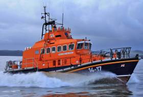
Dunmore East RNLI Assists Yacht With Fouled Sails
#RNLI - Dunmore East RNLI's lifeboat crew launched in the early hours of yesterday morning (Saturday 16 July) to assist a 38ft yacht with four people on board.
The sailing vessel, half a mile east of Dunmore East Harbour, had fouled its sails and could not lower them to enter the harbour.
Minutes after launch at 2.20am, the Trent class lifeboat Elizabeth and Ronald arrived on scene to find the sailing vessel with its sails up and fouled. The vessel found it difficult to keep a heading and crew on board could not lower the sails.
The lifeboat came alongside the yacht and two volunteers boarded the yacht to help fix the issue and lower the sails so the yacht could make its way under power to the harbour.
Escorted by the Dunmore East lifeboat, they yacht reached the safety of the harbour at 3:15am.
Dunmore East RNLI coxswain Michael Griffin said: "The crew of the yacht made the right call; visibility was poor at the time and the outcome could have been a lot worse.
"Our two crew, who went on board the yacht, did a great job in sorting out the sails and lowering them so quickly."
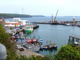
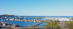
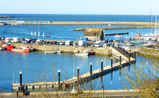
A completely new 60-metre Visitors Pontoon is being installed in Dunmore East in a location immediately northwest of the old Lighthouse and the steel tank pontoon which was placed there as a temporary measure for visitors two years ago writes W M Nixon.
The new pontoon – designated totally for visitor use – is of the same high standard as the new small fishing craft pontoon recently completed in Howth. Features of the Howth pontoon – such as dedicated disabled access – will be replicated in Dunmore East, where the popular Harbour Master Harry McLoughlin is confident that the new facility will be opened as scheduled on July 1st, for although work started as recently as May 9th, the final pile is due to be driven today (May 30th).
The new small fishing craft pontoon in Howth, which shows the standard of the facility being installed at Dunmore East. The Howth Lifeboat is temporarily berthed at the new pontoon until a purpose-built Lifeboat Berth is completed at the Lifeboat House itself – the crane beyond is working on this project. Photo: W M Nixon
Contractors at Dunmore East are L & M Keating of Kilmihil, Co Clare, who have carved out a special niche in Ireland as the “can do” engineers to go to when quality harbour and waterfront works are required. One of their most recent contracts was the award-winning extension of the challenging little ferry port at Doolin in County Clare, which is hugely busy with tour-boats cruising the nearby Cliffs of Moher or making the shortest sea crossing to the nearby Aran Islands, while the firm are also investors themselves in the shoreside infrastrucuture, as they own and operate Kilrush Marina & Boatyard.
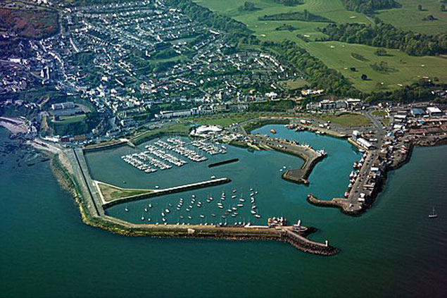
As for future developments in Dunmore East (where a massive dredging operation was recently completed), the word on the grapevine is that a consultative programme has been officially started to explore ways and means of installing an additional breakwater which could lead to the provision of a proper marina.
A busy day in late April at the newly-extended ferry port at Doolin in County Clare. Contractors L & M Keating Ltd received an award for the complete project, which included extensive shoreside works. At high water - as seen here - the old pier (foreground) can be used for additional berthing, but at low water the only ferry access is via the new outer pier. Photo: W M Nixon
Dunmore East RNLI Raises Vital Mayday Funds
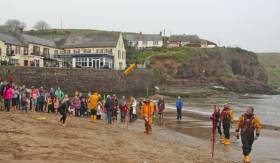
#RNLI - Vital funds have been raised for the RNLI following the annual Dunmore East lifeboat 'Dash & Splash' and yellow welly throwing competition.
The event, which took place at Councillor’s Strand in Dunmore East on Sunday 1 May, was run as part of Mayday, the RNLI’s national annual fundraising campaign.
Dunmore East RNLI fundraising branch volunteer Carol McGeary said: "I’d like to thank everyone who came and supported the Dash & Splash and yellow welly throwing competition.
"We were especially delighted to have Senator Grace O’ Sullivan taking part and leading the swimmers into the water.
"We all had great fun with the welly throwing competition and the crew even challenged our supporters to a beach soccer match. The funds raised will help the RNLI continue to save lives at sea’.
McGeary added that RNLI volunteers in Dunmore East and around Ireland "are willing to drop everything to go and save lives at sea when their pagers beep.
"Mayday is the RNLI’s own call for help, as we rely on the generosity of the public to continue our lifesaving service, which we operate day and night, 365 days a year."
Many of the Mayday fundraising events that have taken place across the country have had a yellow welly theme, in a nod to the essential kit that the RNLI’s lifeboat crew members wear on their feet when they go out to sea to save lives.
Money raised through the Mayday campaign – which ran from Tuesday 26 April to Monday 2 May – will support the RNLI’s lifesaving work. It could be used to fund crew training, contribute towards the running costs of a lifeboat station or buy new crew kit like the yellow wellies.
There is still time to support Mayday. Visit RNLI.org/Mayday to donate.
The RNLI operates 45 lifeboat stations around Ireland. Last year, RNLI lifeboat crews in Ireland launched 1,098 times bringing 1,244 people to safety.
Howth Harbour Thoughts From Home
This weekend has the Irish Sailing Youth Pathway Championships being staged at Howth, and despite the weather the place is buzzing. From being a harbour abandoned in embarrassment for twenty years in the middle of the 19th Century, the peninsula port has gradually evolved to develop a vibrant balance between fishing harbour, sailing centre, and visitor magnet. Longtime local W M Nixon tries to tell it like it is in Howth when seen from the inside.
Howth has most of the advantages and few enough of the disadvantages of being an island. Head home eastward through the isthmus at Sutton Cross (and don’t forget you’re heading eastward - Howth is Dublin’s Eastside, while the Northside is in nearby Ireland), and you shed your Irish identity to become a Howth person. Ideally, this means you become a complete nobody among many other nobodies, for that’s the way we like it.
It must be some sort of defence mechanism, for there was a period in the middle of the 1800s when the powers that be in nearby Ireland preferred to forget our very existence. You see, when the vital links of government between Dublin and London were being maintained by special sailing packet ships, Howth was important because the island of Ireland’s Eye (even in this blog we haven’t the space to explain how it got its name), which is upwards of half a mile off the distinctly rough village, was able to provide an element of natural shelter at a time when Dublin Bay and Dublin Port tended frequently to be disaster areas for shipping.
There were times when the only shelter in Dublin Bay itself was in the very limited space inside Dalkey Island, where a sailing ship could easily be trapped, whereas Howth Sound inside Ireland’s Eye, while north of Dublin Bay and beyond the Baily, nevertheless enabled a potentially embayed ship to cut and run. And yes, that is how the phrase originated.
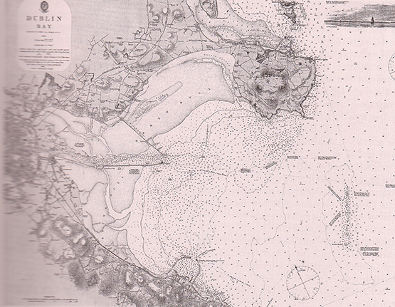
The north side of Dublin Bay in 1692. The Government’s cross-channel packet boats favoured the roadstead anchorage at Howth inside Ireland’s Eye as it provided better shelter than the exposed bay itself, yet there was more space to cut and run than could be found in Dalkey Sound
Thus they built an inn in the village so that people passing through to London, and waiting for the packet boat, would not impose unduly on the hospitality at Howth Castle of the St Lawrence family, unless they were awfully important. And then when the engineer Thomas Telford was commissioned to build a road linking London with Dublin through Holyhead, naturally on the Irish side he followed the official view of things and continued his road through Howth and on towards Dublin, in light of the fact that offical policy was that the Government harbour would be built at Howth.
And build it they did, from about 1807 onwards, with John Rennie in charge. But with the gathering prosperity and increased trade after the final end of the Napoleonic Wars in 1815, the movement for the improvement of Dublin port and the building of an “asylum harbour” at Dunleary within Dublin Bay gained traction, and by 1817 what would soon become the highly-fashionable Kingstown Harbour was already under construction before Howth Harbour was even properly finished.
Once the new harbour had been completed at Dunleary on the south side of Dublin Bay and re-named Kingstown, the smaller shallower harbour at Howth was forgotten about for twenty years
Nevertheless Howth continued as the official mailboat port until 1834, by which time even the most stubborn official mind had to recognise that everyone else had long since gone Southside. So at last the powers that be followed. And in doing so, they tacitly agreed that the best way to deal with the memory of the ENORMOUS expenditure of building shallow sandy Howth Harbour was to ignore the place’s very existence for as long as possible.
The local fishermen continued to use the sandy creek of Balydoyle as their main port as they’d always done, while Howth seems to have been out of bounds to just about everyone. It was declared an inviolate Royal Harbour which might be of strategic value in the event of attack by Barbary pirates or Eskimo marine commando units or whatever, and for maybe fifteen years Howth simply slumbered, quietly silting up.
But by the 1850s, the growth of the fishing industry through travelling fleets of trawlers from the great fishing ports of Devon and Cornwall and Scotland and the east coast of England meant that increasing numbers of high-powered fishing skippers, almost entirely from Britain, were demanding that they be allowed to use Howth, and by the 1860s it had been designated a “Fishing Station”.
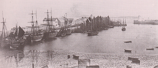
Howth Harbour in the 1870s, when it had become a “Fishing Station”
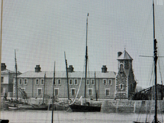
Much the same thing happened at Dunmore East, which was initially the packet boat port for Waterford, and the local fishermen weren’t really allowed into it at all. But then the advent of steamships meant the packet boats could go straight up to Waterford itself, and after an interval lying idle, Dunmore East also became a Fishing Station. But it was only because nobody else further up the pecking order had a use for it – in those days, fishermen were expected to fend for themselves.
So for thirty years and more, Howth was almost totally devoted to fishing, but in 1875 the famous Judge Boyd – he is referenced in Ulysses – took a lease on the harbourside Howth House which had originally been built as a residence for John Rennie, the engineer building the harbour. The Judge was well got, as his main house was in Merrion Square – it’s now the French Embassy – but as he was something of a maverick, he decided that he’d pursue his sport of sailing through Howth rather than Kingstown.
Judge Boyd was such a noted Dublin character that he was referenced in Joyce’s Ulysses
Thanks to Judge Boyd’s influence, Howth had a government dredger almost permanently on station from 1888 onwards. And for those who would seek further cultural references, the Yeats family lived in the house on the foreshore just to the left of the fishing boat from 1880 to 1882
A maverick he may have been, but he had influence in high places, and when the silting of Howth became even worse in the 1880s, hampering the seasonal activities of the travelling fishing fleets, the Judge saw to it that Howth got its own government dredger as an almost permanent feature.
The trouble is, the fishing was too successful – the herring were fished almost to extinction. By the 1890s, fleets visiting Howth were declining rapidly, but this in turn facilitated the development of the local sailing club, founded mostly by Judge Boyd’s sons in 1895.
However, the old Judge had lost none of his sparkle, for in 1892 he had bought the supposedly out-classed Fife 70-footer Thalia from the Clyde, and proceeded to win races left right and centre with her. Often he helmed her himself, but if he felt like a rest, the talented professional skipper who came with the boat was Owen Bissett, who stayed on in Ireland with such commitment that today one of Howth’s most able sailors, Ross McDonald, is Owen Bissett’s great-great grandson.
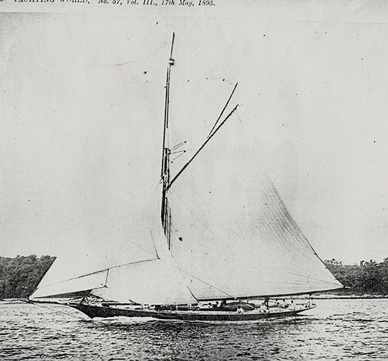
Judge Boyd’s Thalia racing in the Clyde – in Clyde Fortnight 1897 she won 140 pounds in prize money, the third highest in the regatta. Though he raced the boat himself, Judge Boyd also had a professional skipper in Owen Bissett, great great grandfather of today’s successful Howth skipper Ross McDonald
And if you wonder how the Judge managed to keep a large engineless yacht in little Howth Harbour, a yacht whose overall length from mainboom end to bowsprit end was well over a hundred feet, the answer is he treated Howth Harbour as if it was his private marina. After all, it was he who ensured it was dredged, so hadn’t he every right to keep Thalia in a very handy berth inside the nib on the West Pier? And if he happened to omit to retract Thalia’s long bowsprit which protruded well beyond the end of the nib, then heaven help any fishing skipper whose ancient craft managed to get fouled up in this exquisite piece of classic yacht equipment.
Regatta day at Howth, and Thalia in her berth inside the nib on the West Pier
The perfect private berth – Thalia at the West Pier in Howth around 1900
It’s difficult to escape the feeling that the Judge’s four sons thought the old man was maybe a bit over the top, for in their new Howth Sailing Club they promoted the notion that “Small is Beautiful”. When the oldest brother Herbert designed the new one design class for Howth in the Autumn of 1897, the resulting Howth 17s were of very modest proportions, just 22ft 6ins in overall length.
In time, the mighty Thalia ceased to be a feature of Howth Harbour. She was of such a size that the easiest way to lay her up was a winter berth afloat in the Grand Canal basin in Dublin. But as she had been built on steel frames with copper fastenings, she was virtually on fire with electrolysis, and her days were short – by 1910 she had gone.
A much more modest proposition – the handy little Howth 17s were introduced in 1898, and they hope to have 18 boats racing this summer
From time to time, the Howth 17s add new boats – this is Erica and Isobel joining the fleet in 1988
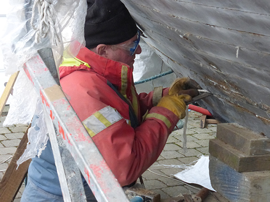
The joys of classic yacht ownership…..Pat Heydon working in early March on the re-caulking of Gladys (built 1907), which he co-owns with Eddie Ferris and Ian Byrne. Photo: W M Nixon
But the Howth 17s plough steadily on 118 years later, thanks to a sort of group scheme of mutual help when a boat needs serious work done, with longtime owner Ian Malcolm as the multi-talented core of a sort of men and women’s shed movement with a maritime purpose. The purpose is to get in as much racing as they can, with as many boats as humanly possible. This season they’ll have 18 of them sailing, while a classic boat festival at Howth in early August has already roped in Mermaid Week, and they and the Seventeens will be more than happy to welcome other long-established wooden craft.
As for Howth generally, the inevitable conflict between the needs of fishing craft and the needs of recreational boating were more or less resolved back in 1982, when the recreationals were moved into the eastern part of the harbour with its marina and - in time - a completely new clubhouse, while the western section became a state-of-the-art fish dock with synchro-lift and all the trimmings.
It was a case of good fences making good neighbours, and maybe the harbour users of Howth became too contented, for the powers-that-be seemed to forget that in a harbour set beside a sandy channel through which the tide can flow with some vigour, routine maintenance includes regular dredging.
In The Netherlands, arguably the best-run maritime nation in the world, every harbour is dredged as a matter of routine every four to five years, regardless of whether or not there has been significant silting. It’s just done, and that’s how it is – it’s the Dutch way.
But in Ireland, it seems we have to chivvy the authorities to do what should be a matter of routine, and ultimately it all seems to come back to the door of the Office of Public Works, which despite its name seems to think that it’s activities should be carried out in as private a way as possible. Maybe it should be re-named the Office of Good Works By Stealth, for the word is that Howth is going to be dredged, and it might well be sooner than later.
Meanwhile, the Department of Agriculture & Fisheries have been quietly beavering away providing the small boat fishermen with their own rather splendid pontoon. It’s an extremely fine bit of work, but so far as we know, it is only recently that the notice has gone up telling us what it’s all about.
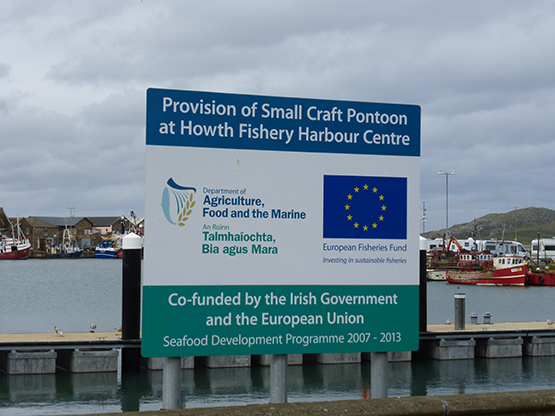
It’s coming to a harbour near you…….the notice of the new facility was erected without any fanfare...
...and for the time being there’s no news of when the new pontoon will be officially opened
As for actually getting the use of it, the situation is now a bit reminiscent of the 1840s. There’s this really classy and useful bit of infrastructure, just as there was once the unused Howth Harbour back in the 1840s. But nobody is as yet allowed near it. The smaller fishing craft still raft up outside each other, and their crews still have to clamber up the quayside.
There’s probably a perfectly good reason why the new pontoon has not yet opened for business. But as our email enquiry to the Department has gone unanswered, we can only assume that until a new Government is formed and there’s a fully-accredited new Minister ready to sweep out in the limo to perform the opening ceremony with all the attendant pomp and kudos, then this lovely pontoon will continue to float serenely on, just like the Sleeping Beauty.

While Howth’s new small fishing craft pontoon awaits its official opening, its future users continue to raft up alongside each other at the quay. Photo: W M Nixon


 Michael Murphy Schull Harbour Sailing Club (SHSC), Eric Coogan Heineken Ireland, Mark Murphy, Commodore SHSC, Jack Allen SHSC, Carmel O'Regan SHSC, Cornelious Ndlovu, Schull Harbour Hotel Operations Manager and Derval Murphy SHSC")

