Menu

Ireland's sailing, boating & maritime magazine

Inland afloat headers


Displaying items by tag: Galway Harbour

In my last Podcast, I expressed the opinion that it is strange how things happen. This was again underlined for me as I prepared the new edition of my maritime programme which you can listen to below.

Galway Port Company has an ambitious €120m. plan for the future. It is going through the planning process at present, which has delayed it with various checks and examinations of what is proposed.

But the port company is determined to push the process forward and to achieve its goal in creating a modern port with the best of facilities on the Western coastline.

Galway is ideally placed to be a TransAtlantic port, so it has been said many times, but why has this not happened?

Is it possible that, as the business and economic leaders of the city tried to establish a TransAtlantic shipping line, their efforts were deliberately sabotaged by non-Irish ports which did not want Galway to command this trade?

Was the first ship chartered to run such a service, which had been given permission to carry what was then a valuable mail service in financial terms for the shipping service, deliberately sabotaged?

How could it strike the only rock in Galway Bay as it sailed in for the start of the service, leading to huge controversy and damaging the western port’s future?

The story, still an unsolved mystery, is told on THIS ISLAND NATION by author, journalist and Galwayman, Ray Burke. It is a fascinating story, well worth listening to and reading about. He links it into Ulysses, Nora Barnacle and James Joyce in his book ‘Joyce County – Galway and James Joyce’.

Click below to hear the story of how the voyage of the Indian Empire, intended to start Galway’s first TransAtlantic service, suffered a bad start in Galway Bay.


Published in Island Nation

#AranIslands – As talks today to resolve the ongoing Aran Islands ferries dispute over passenger levies with Galway County Council, Afloat.ie takes a snapshot of a separate but freight-only operator providing vital supplies to islanders, writes Jehan Ashmore.

The affected Island Ferries Teoranta passenger ferry service: Rossaveel-Kilronan on Inis Mór, the largest of the Oileán Árann / Aran Islands was due to end last week, however, as Afloat previously covered the service is still operating as “a gesture of goodwill to the Islanders”.The ferry service will remain in place until 17 January 2017 however this date remains under review subject to how the discussions progress on the council-imposed passenger levy for the non-PSO ferry route to Inis Mór. In recent years this route has been subject to a sharp rise in fares.

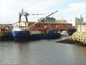
As for the freight-only operator, Lasta Mara Teoranta, the company since 2005 has the Government contract to carry cargo not just serving Inishmor but also Inis Meain and Inis Oirr. These services are an essential lifeline for islanders. Lasta Mara is the main cargo company serving the Aran Islands by operating from the mainland based in Galway Port using MV Bláth na Mara (1983/330grt).

All the daily needs of the islanders are carried in containers on board Bláth na Mara from food stuffs (chill and frozen), to household goods, furniture and fuel. As for larger items such as vehicles and old fashioned form of transport that includes horses (given the tourist jaunting carts) and other lifestock are also conveyed on the coastal freighter. 

A ‘roll-on roll-off’ i.e. ro-ro service from Rossaveel, Connemara is also provided by Lasta Mara using the MV Chateau-Thierry (see report photo) a former US Army tank landing craft. As previously reported the vessel brought emergency electrical generators due to power-cuts earlier this year.

Otherwise Chateau-Thierry's routine heavy goods cargoes are in the form of trucks, diggers and heavy plant and machinery. Such construction related vehicles were transported by Chateau Thierry from the mainland to Kilronan Harbour during the building of the new harbour. These vehicles rolled off the bow loading ramp onto the sandy beach at Kilronan, the capital of the Aran Islands. 

The costs to pay for Kilronan's new outer harbour (see engineering award) are derived through the passenger levies which are at centre stage of the ferry dispute.

As for the cargo service in order to maintain all perishable cargoes remain frozen before departing Galway Port, the outer pier is where a warehouse is equipped adjacent to where Bláth na Mara berths. The Galway-Aran Islands routes should also be noted as Ireland’s longest distance domestic (island serving) commercial cargo service.

It is on such trading routes that the old traditional joint passenger /cargo service had run up to 1988. This was carried out by the State owned Coras Iompair Eireann (CIE) group’s vessel Naomh Éanna.

The veteran vessel built by Dublin Liffey Drydock Company in 1958 ran on the route for four decades. Since the service closed Naomh Eanna has remained languishing in the capital’s Grand Canal Dock Basin. In recent years she was transferred to a disused graving dock having been saved from scrapping. Against this backdrop there have been plans to restore the historic Irish built ship. 
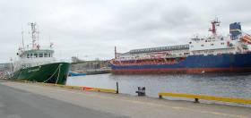
 

Published in Ports & Shipping

#GalwayAnchorage – Holland America Line’s Prinsendam continues her 28 Day Celtic & Bourgundian Explorer Cruise with an anchorage call on Galway Bay today, writes Jehan Ashmore.

Prior to the cruiseship's arrival off Galway Port, Prinsendam so far has visited Dublin, Belfast (as reported), the Scottish western isles and Killybegs yesterday.

She has a capacity for 766 passengers and 460 crew and in which cruisegoers are been tendered ashore to the City of the Tribes. The US company founded in 1928 has a history of trans-Atlantic 'liner' calls taking anchorage in Galway Bay.

During the careers of their Maasdam and Ryndam this required the use of a dedicated liner tender, Calshot which HAL purchased in 1964 through a subsidiary, Port & Liner Services (Ireland) Ltd.

Prinsendam is the final caller out of six cruiseships this season, however Galway Harbour Company have scheduled in for 9 calls in 2017. Again this will include HAL's Prinsendam, at 38,848 gross tonnage which is deemed small these days. Much larger cruiseships are planned as the port have proposed an outer deeper water port which would not require anchoring off Mutton Island. 

In the meantime, at the entrance to Galway on the outer pier is where a fleet of the cruiseships tenders are ferrying visitors back and forth. On the adjacent berth is LastMara Teo’s freight-only Aran Islands serving vessel, Bláth na Mara, whose fleetmate Chateau-Thierry transported generators from Rossaveal during power cuts on two of the three islands. 

Also berthed but alongside the quays of the Claddagh area is the former Commissioners of Irish Lights Dun Laoghaire Harbour based buoy-towage tender Puffin.

The Bristol built tug retains its original name having been acquired in 2011. Afloat two years later made a trip on board Puffin, which also carries out ship mooring lines-boat duties along the Shannon Estuary. On that occasion, this involved a repositioning passage from the Rusal Aughinish Alumina plant jetty to the Port of Foynes.

Published in Cruise Liners

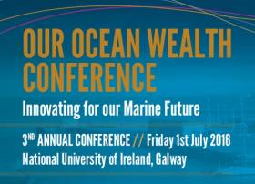
#OurOceanWealth - Registration is now open for the 2016 Our Ocean Wealth Conference at NUI Galway on Friday 1 July.

As previously reported on Afloat.ie, this year's conference will again take place alongside SeaFest, Ireland's national maritime festival, hosted this year in Galway Harbour from 2-3 July.

The full conference agenda is yet to be announced but items of focus will include:

  • Progress on the implementation of Harnessing Our Ocean Wealth - Ireland's Integrated Marine Plan
  • Into the Blue: Economy and Growth
  • Map, Observe, Predict: Innovating Across the Atlantic
  • Our New Relationship With the Sea

For more information or to register for the conference visit www.ouroceanwealth.ie.

Published in News Update

#OurOceanWealth - NUI Galway will host the third annual Our Ocean Wealth Conference on Friday 1 July.

The previous two conferences – in the inaugural event in Dublin Castle and last summer's in Cork Harbour – have outlined the progress in implementing the Government's 2012 Harnessing Our Ocean Wealth: An Integrated Marine Plan for Ireland.

And like last year's event in Ringaskiddy and Haulbowline, this year's conference will precede the return of SeaFest, Ireland's national maritime festival, in Galway Harbour from 2-3 July.

Further details are available at the Our Ocean Wealth website HERE.

Another upcoming date for the diary is the 26th Irish Environmental Research Colloquium.

'Ecosystem Services for a Sustainable Future' is the title of Environ 2016 at the University of Limerick from Tuesday 22 to Thursday 24 March.

For more information contact Sinead Macken at 086 807 1498 or [email protected] or visit www.environ2016.org

Published in News Update

There's an impressive glow from the Christmas lights hoisted high on the 90–foot mast of Atlantic Blue, a Hanse 531 yacht, moored in Galway Harbour this Christmas.

The maritime yuletide decorations have lit up the west coast harbour that is making an ambitious bid for a Tall Ships Visit in 2019.

Published in Galway Harbour
Tagged under

#TallShips - Galway could join the running to host the Tall Ships Races in 2019, as the Connacht Tribune reports.

City councillor and former Galway mayor Padraig Conneely is spearheading efforts to attract the tall ships to Galway Harbour – and the potential €50 million boost to the economy they'd bring with them.

Preliminary discussions have already taken place to explore the viability of a bid for the annual sailing spectacle in light of Dublin's opting out of the running for 2019.

“Galway has a great track record in hosting maritime events and the city has proven itself to be a great host for such events," said Cllr Conneely, citing the Volvo Ocean Race finale in 2012 and the stopover in 2009.

The Connacht Tribune has more on the story HERE.

Published in Tall Ships
Tagged under

#Powerboats - The Venture Cup for powerboat racers headlines a "bumper calendar of events" in Galway Harbour next June, as the Connacht Tribune reports.

Galway will be the only in-port race stop on the 1,000 mile challenge, reportedly "the longest, toughest and most prestigious powerboat race in the world".

And what in-port racing that will be, as up to 25 of the world's very best powerboat racers will blitz past Salthill Promenade towards the Atlantic from 16 June at such speeds that they'll be using the Aran Islands "as a chicane".

Not only that, but the celebrity involvement is sure to bring out the crowds to Galway and ports clockwise around Ireland from Cork to Dublin.

TV adventurer Bear Grylls is believed to have booked a berth on board one of the super-speed boats that can go as fast as 240mph, while Ireland will be represented by the youngest competitor, 18-year-old Adam Brennan – son of hotelier and host of RTÉ TV's At Your Service, John Brennan.

The Connacht Tribune has more on the story HERE.

Published in Powerboat Racing

#GalwayPort - Business leaders have welcomed the news that the €126 million Galway Port extension project will be proceed under the IROPI section of the EU Habitats Directive.

According to the Galway Independent, the decision by An Bord Pleanála to proceed under IROPI – or Imperative Reasons of Overriding Public Interest – is a first for Ireland.

Progress will involve establishing replacement habitats for those that would be adversely affected by the port extension. As previously reported on Afloat.ie, it was determined that a number of reef, mud and sand habitats would be destroyed by the 24 hectares of land reclamation required.

But there's better news for those with environmental concerns, as planners have determined that two nearby Natura sites – the Inner Galway Bay Special Protection Are and the Lough Corrib Special Area of Conservation – will see no impact, while priority habitats at Lough Atalia and Renmore Loughs will not be "negatively affected".

The board has also recommended "tight co-operation" between the Galway Harbour Company and local authorities to ensure conservation is made top priority throughout the project.

The Galway Independent has more on the story HERE.

Published in Galway Harbour

#GalwayPort - Parts of the current expansion plan for Galway Harbour would have a significant adverse impact on Galway Bay, according to An Bord Pleanála - a week ahead of the expected decision that has already been delayed for many months.

As RTÉ News reports, the planning body has invited the Galway Harbour Company to suggest moves it can make to offset any lasting damage to habitats in what is a candidate for designation as a Special Area of Conservation.

It has been confirmed that the €126 million redevelopment scheme, which involves reclaiming 24 hectares from the sea, would destroy a number of reef, mud and sand habitats.

Pending that feedback, planners will then decide whether to refer the expansion scheme to Brussels under the Derogation of the Habitats Directive for projects of overriding public interest.

Published in Galway Harbour
Page 7 of 10

General Information on using Waterways Ireland inland navigations

Safety on the Water

All users of the navigations are strongly recommended to make themselves aware of safety on the water for whatever activity they are involved in and to read the advice offered by the various governing bodies and by:

The Dept. of Transport, Ireland: www.gov.ie/transport and The Maritime and Coastguard Agency, UK, The RNLI – Water Safety Ireland for information in terms of drowning prevention and water safety.

Registration of Vessels

All vessels using the Shannon Navigation, which includes the Shannon-Erne Waterways and the Erne System must be registered with Waterways Ireland. Only open undecked boats with an engine of 15 horsepower or less on the Shannon Navigation, and vessels of 10 horsepower or less on the Erne System, are exempt. Registration is free of charge.

Craft registration should be completed online at: https://www.waterwaysireland.org/online-services/craft-registration

Permits for use of the Grand and Royal Canals and the Barrow Navigation

All vessels using the Grand and Royal Canals and the Barrow Navigation must display appropriate valid Permit(s) i.e A Combined Mooring and Passage Permit (€126) and if not intending to move every five days, an Extended Mooring Permit (€152).

Permit applications should be completed online at: https://www.waterwaysireland.org/online-services/canal-permits

Passage on the Royal and Grand Canals – Dublin Area

For boat passage through the locks east of Lock 12 into / out of Dublin on either the Royal or Grand Canals, Masters are requested to contact the Waterways Ireland Eastern Regional Office (M-F 9.30am-4.30pm) on tel: +353(0)1 868 0148 or email [email protected] prior to making passage in order to plan the necessary lock-keeping assistance arrangements.

On the Grand Canal a minimum of two days notice prior to the planned passage should be given, masters should note that with the exception of pre-arranged events, a maximum of 2 boats per day will be taken through the locks, travelling either east or west.

Movements in or out of the city will be organised by prior arrangement to take place as a single movement in one day. Boaters will be facilitated to travel the system if their passage is considered to be safe by Waterways Ireland and they have the valid permit(s) for mooring and passage.

Newcomen Lifting Bridge

On the Royal Canal two weeks’ notice of bridge passage (Newcomen Lifting Bridge) is required for the pre-set lift date, and lock assistance will then also be arranged. A minimum of 2 boats is required for a bridge lift to go ahead.

Waterways Ireland Eastern Regional Office (Tel: +353(0)1 868 0148 or [email protected] ) is the point of contact for the bridge lift.

A maximum number of boats passing will be implemented to keep to the times given above for the planned lifts (16 for the Sat / Sun lifts & 8 for the weekday lifts). Priority will be given on a first come first served basis.

On day of lift, boaters and passengers must follow guidance from Waterways Ireland staff about sequence of passage under bridge & through Lock 1, and must remain within signed and designated areas.

Events Held on the Waterways

All organised events taking place on the waterways must have the prior approval of Waterways Ireland. This is a twelve week process and application forms must be accompanied with the appropriate insurance, signed indemnity and risk assessment. The application should be completed on the Waterways Ireland events page at :

https://www.waterwaysireland.org/online-services/event-approval

Time Limits on Mooring in Public Harbours

On the Shannon Navigation and the Shannon-Erne Waterway craft may berth in public harbours for five consecutive days or a total of seven days in any one month.

On the Erne System, revised Bye Laws state that: No master or owner shall permit a vessel, boat or any floating or sunken object to remain moored at or in the vicinity of any public mooring, including mooring at any other public mooring within 3 kilometres of that location, for more than 3 consecutive days and shall not moor at that same mooring or any other public mooring within 3 kilometres of that location within the following 3 consecutive days without prior permission by an authorised official.

Winter Mooring on the Shannon Navigation and Shannon Erne Waterway

Winter mooring may be availed of by owners during the period 1 Nov to 31 Mar by prior arrangement and payment of a charge of €63.50 per craft. Craft not availing of Winter Mooring must continue to comply with the “5 Day Rule”. Winter Mooring applications should be completed online at : https://www.waterwaysireland.org/online-services/winter-moorings-booking

Owners should be aware that electricity supply and water supply to public moorings is disconnected for the winter months. This is to protect against frost damage, to reduce running costs and to minimise maintenance requirements during the winter months.

Vessel owners are advised that advance purchasing of electricity on the power bollards leading up to the disconnection date should be minimal. Electricity credit existing on the bollards will not be recoverable after the winter decommissioning date. Both services will be reinstated prior to the commencement of the next boating season.

Smart Cards

Waterways Ireland smart cards are used to operate locks on the Shannon Erne Waterway, to access the service blocks, to use the pump-outs along the navigations, to avail of electrical power at Waterways Ireland jetties.

Berthing in Public Harbours

Masters are reminded of the following:

  • Equip their vessel with mooring lines of appropriate length and strength and only secure their craft to mooring bollards and cleats provided for this purpose.
  • Ensure the available berth is suitable to the length of your vessel, do not overhang the mooring especially on finger moorings on floating pontoon moorings.
  • Ensure mooring lines, electric cables and fresh water hoses do not create a trip hazard on public jetties for others users.
  • Carry sufficient fenders to prevent damage to your own vessel, other vessels and WI property.
  • Allow sufficient space between your vessel and the vessel ahead /astern (c.1m) for fire safety purposes and /or to recover somebody from the water.
  • Do not berth more than two vessels side by side and ensure there is safe access/egress at all times between vessels and onto the harbour itself.
  • Do not berth in such a way to prevent use of harbour safety ladders, slipways or pump-outs.
  • Do not allow the bow of your vessel to overhang the walkway of a floating mooring thus creating a hazard for others with an overhanging anchor or bow fendering.
  • Animals are not allowed to be loose or stray at any time.
  • Harbour and jetty infrastructure such as railings, power pedestals, fresh water taps, electric light poles, safety bollards, ladders etc are not designed for the purpose of mooring craft , they will not bear the strain of a vessel and will be damaged.
  • At Carrybridge on the Erne System, Masters of vessels are not permitted to use stern on mooring. Masters of vessels must use the mooring fingers for mooring of vessels and for embarkation / disembarkation from vessels.

Passenger Vessel Berths

Masters of vessels should not berth on passenger vessel berths where it is indicated that an arrival is imminent. Passenger vessels plying the navigations generally only occupy the berths to embark and disembark passengers and rarely remain on the berths for extended periods or overnight.

Lock Lead-in Jetties

Lead-in jetties adjacent to the upstream and downstream gates at lock chambers are solely for the purpose of craft waiting to use the lock and should not be used for long term berthing.

Vessel Wake

Vessel wake, that is, the wave generated by the passage of the boat through the water, can sometimes be large, powerful and destructive depending on the hull shape and engine power of the vessel. This wake can be detrimental to other users of the navigation when it strikes their craft or inundates the shoreline or riverbank. Masters are requested to frequently look behind and check the effect of their wake / wash particularly when passing moored vessels, on entering harbours and approaching jetties and to be aware of people pursuing other activities such as fishing on the riverbank.

Speed Restriction

A vessel or boat shall not be navigated on the Shannon Navigation at a speed in excess of 5 kph when within 200 metres of a bridge, quay, jetty or wharf, when in a harbour or canal or when passing within 100 metres of a moored vessel or boat.

Vessels navigating the Shannon-Erne Waterway should observe the general 5 kph speed limit which applies along the waterway. This is necessary in order to prevent damage to the banks caused by excessive wash from vessels.

Vessels navigating the Erne System should observe the statutory 5kt / 6mph / 10kph speed limit areas.

A craft on the Royal and Grand canals shall not be navigated at a speed in excess of 6km per hour.

A craft on the Barrow Navigation shall not be navigated at a speed in excess of 11km per hour except as necessary for safe navigation in conditions of fast flow.

Bank Erosion

Narrow sections of all the navigations are particularly prone to bank erosion due to the large wash generated by some craft. Masters are requested to be vigilant and to slow down to a speed sufficient to maintain steerage when they observe the wash of their craft inundating the river banks.

Unusual Waterborne Activity

Unusual waterborne vessels may be encountered from time to time, such as, hovercraft or amphibious aircraft / seaplanes. Masters of such craft are reminded to apply the normal “Rule of the Road” when they meet conventional craft on the water and to allow extra room to manoeuvre in the interest of safety.

Sailing Activity

Mariners will encounter large numbers of sailing dinghies from late June to August in the vicinity of Lough Derg, Lough Ree and Lower Lough Erne. Sailing courses are marked by yellow buoys to suit weather conditions on the day. Vessels should proceed at slow speed and with due caution and observe the rules of navigation when passing these fleets, as many of the participants are junior sailors under training.

Rowing

Mariners should expect to meet canoes and vessels under oars on any part of the navigations, but more so in the vicinity of Athlone, Carrick-on-Shannon, Coleraine, Enniskillen and Limerick. Masters are reminded to proceed at slow speed and especially to reduce their wash to a minimum when passing these craft as they can be easily upset and swamped due to their very low freeboard and always be prepared to give way in any given traffic situation.

Canoeing

Canoeing is an adventure sport and participants are strongly recommended to seek the advice of the sport’s governing bodies i.e Canoeing Ireland and the Canoe Association of Northern Ireland, before venturing onto the navigations.

Persons in charge of canoes are reminded of the inherent danger to these craft associated with operating close to weirs, sluice gates, locks and other infrastructure particularly when rivers are in flood and large volumes of water are moving through the navigations due to general flood conditions or very heavy localised precipitation e.g. turbulent and broken water, stopper waves. Shooting weirs is prohibited without prior permission of Waterways Ireland.

Canoeists should check with lockkeepers prior entering a lock to ensure passage is done in a safe manner. Portage is required at all unmanned locks.

Canoe Trail Network – "Blueways"

Masters of powered craft are reminded that a canoe trail network is being developed across all navigations and to expect more organised canoeing along these trails necessitating slow speed and minimum wash when encountering canoeists, rowing boats etc

Rockingham and Drummans Island Canals – Lough Key

It is expected that work on Rockingham and Drummans Island Canals on Lough Key will be completed in 2021. Access to these canals will be for non-powered craft only, eg canoes, kayaks, rowing boats.

Fast Powerboats and Personal Watercraft (Jet Skis)

Masters of Fast Powerboats (speed greater than 17kts) and Personal Watercraft (i.e.Jet Skis) are reminded of the inherent dangers associated with high speed on the water and especially in the confines of small bays and narrow sections of the navigations. Keeping a proper look-out, making early alterations to course and /or reducing speed will avoid conflict with slower vessels using the navigation. Personal Watercraft are not permitted to be used on the canals.

Towing Waterskiers, Wakeboarders, Doughnuts etc

Masters of vessels engaged in any of these activities are reminded of the manoeuvring constraints imposed upon their vessel by the tow and of the added responsibilities that they have to the person(s) being towed. These activities should be conducted in areas which are clear of conflicting traffic. It is highly recommended that a person additional to the master be carried to act as a “look-out” to keep the tow under observation at all times.

Prohibition on Swimming

Swimming in the navigable channel, particularly at bridges, is dangerous and is prohibited due to the risk of being run over by a vessel underway in the navigation.

Age Restrictions on operating of powered craft

In the Republic of Ireland, Statutory Instrument 921 of 2005 provides the legal requirements regarding the minimum age for operating of powered craft. The Statutory Instrument contains the following requirements:

- The master or owner of a personal watercraft or a fast power craft shall take all reasonable steps to ensure that a person who has not attained the age of 16 years does not operate or control the craft

- The master or owner of a pleasure craft powered by an engine with a rating of more than 5 horse power or 3.7 kilowatts shall take all reasonable steps to ensure that a person who has not attained the age of 12 years does not operate or control the craft.

Lifejackets and Personal Flotation Devices (PFDs)

Lifejackets and PFD’s are the single most important items of personal protective equipment to be used on a vessel and should be worn especially when the vessel is being manoeuvred such as entering / departing a lock, anchoring, coming alongside or departing a jetty or quayside.

In the Republic of Ireland, Statutory Instrument 921 of 2005 provides the legal requirements regarding the wearing of Personal Flotation Devices. The Statutory Instrument contains the following requirements:

- The master or owner of a pleasure craft (other than a personal watercraft) shall ensure, that there are, at all times on board the craft, sufficient suitable personal flotation devices for each person on board.

- A person on a pleasure craft (other than a personal watercraft) of less than 7 metres length overall shall wear a suitable personal flotation device while on board an open craft or while on the deck of decked craft, other than when the craft is made fast to the shore or at anchor.

- The master or owner of a pleasure craft (other than a personal watercraft) shall take all reasonable steps to ensure that a person who has not attained the age of 16 years complies with paragraph above.

- The master or owner of a pleasure craft (other than a personal watercraft), shall take all reasonable steps to ensure that a person who has not attained the age of 16 years wears a suitable personal flotation device while on board an open craft or while on the deck of a decked craft other than when it is made fast to the shore or at anchor.

- The master or owner of a pleasure craft (other than a personal watercraft) shall take all reasonable steps to ensure that a person wears a suitable personal flotation device, at all times while – (a) being towed by the craft, (b) on board a vessel or object of any kind which is being towed by the craft.

Further information is available at: http://www.irishstatutebook.ie/eli/2005/si/921/made/en/print

Firing Range Danger Area – Lough Ree

The attention of mariners is drawn to the Irish Defence Forces Firing Range situated in the vicinity of buoys No’s 2 and 3, on Lough Ree on the Shannon Navigation. This range is used regularly for live firing exercises, throughout the year, all boats and vessels should stay clear of the area marked with yellow buoys showing a yellow "X" topmark and displaying the word "Danger".

Shannon Navigation, Portumna Swing Bridge Tolls

No attempt should be made by Masters’ of vessels to pay the bridge toll while making way through the bridge opening. Payment will only be taken by the Collector from Masters when they are secured alongside the jetties north and south of the bridge.

Navigating from Killaloe to Limerick on the Shannon Navigation

The navigation from Killaloe to Limerick involves passage through Ardnacrusha locks, the associated headrace and tailrace and the Abbey River into Limerick City. Careful passage planning is required to undertake this voyage. Considerations include: lock passage at Ardnacrusha, water flow in the navigation, airdraft under bridges on Abbey River in Limerick, state of tide in Limerick

Users are advised to contact the ESB Ardnacrusha hydroelectric power station (00353 (0)87 9970131) 48 hours in advance of commencing their journey to book passage through the locks at Ardnacrusha. It is NOT advised to undertake a voyage if more than one turbine is operating (20MW), due to the increased velocity of flow in the navigation channel, which can be dangerous. To ascertain automatically in real time how many turbines are running, users can phone +353 (0)87 6477229.

For safety reasons the ESB has advised that only powered craft with a capacity in excess of 5 knots are allowed to enter Ardnacrusha Headrace and Tailrace Canals.

Passage through Sarsfield Lock should be booked on +353-87-7972998, on the day prior to travel and it should be noted also that transit is not possible two hours either side of low water.

A Hydrographic survey in 2020 of the navigation channel revealed that the approach from Shannon Bridge to Sarsfield Lock and the Dock area has silted up. Masters of vessels and water users are advised to navigate to the Lock from Shannon bridge on a rising tide one or two hours before High Tide.

Lower Bann Navigation

The attention of all users is drawn to the “Users Code for the Lower Bann”, in particular to that section covering “Flow in the River” outlining the dangers for users both on the banks and in the navigation, associated with high flow rates when the river is in spate. Canoeists should consult and carry a copy of the “Lower Bann Canoe Trail” guide issued by the Canoe Association of Northern Ireland. Users should also contact the DfI Rivers Coleraine, who is responsible for regulating the flow rates on the river, for advisory information on the flow rates to be expected on any given day.

DfI Rivers Coleraine. Tel: 0044 28 7034 2357 Email: [email protected]

Lower Bann Navigation – Newferry – No wake zone

A No Wake Zone exists on the Lower Bann Navigation at Newferry. Masters of vessels are requested to proceed at a slow speed and create no wake while passing the jetties and slipways at Newferry.

Overhead Power Lines (OHPL) and Air draft

All Masters must be aware of the dangers associated with overhead power lines, in particular sailing vessels and workboats with cranes or large air drafts. Voyage planning is a necessity in order to identify the location of overhead lines crossing the navigation.

Overhead power line heights on the River Shannon are maintained at 12.6metres (40 feet) from Normal Summer level for that section of navigation, masters of vessels with a large air draft should proceed with caution and make additional allowances when water levels are high.

If a vessel or its equipment comes into contact with an OHPL the operator should NOT attempt to move the vessel or equipment. The conductor may still be alive or re-energise automatically. Maintain a safe distance and prevent third parties from approaching due to risk of arcing. Contact the emergency services for assistance.

Anglers are also reminded that a minimum ground distance of 30 metres should be maintained from overhead power lines when using a rod and line.

Submarine Cables and Pipes

Masters of vessels are reminded not to anchor their vessels in the vicinity of submarine cables or pipes in case they foul their anchor or damage the cables or pipes. Look to the river banks for signage indicating their presence.

Water Levels - Precautions

Low Water Levels:

When water levels fall below normal summer levels masters should be aware of:

Navigation

To reduce the risk of grounding masters should navigate on or near the centreline of the channel, avoid short cutting in dog-legged channels and navigating too close to navigation markers.

Proceeding at a slow speed will also reduce “squat” effect i.e. where the vessel tends to sit lower in the water as a consequence of higher speed.

Slipways

Reduced slipway length available under the water surface and the possibility of launching trailers dropping off the end of the concrete apron.

More slipway surface susceptible to weed growth requiring care while engaged in launching boats, from slipping and sliding on the slope. Note also that launching vehicles may not be able to get sufficient traction on the slipway once the craft is launched to get up the incline.

Bank Erosion

Very dry riverbanks are more susceptible to erosion from vessel wash.

Lock Share

Maximising on the number of vessels in a lock will ensure that the total volume of water moving downstream is decreased. Lock cycles should be used for vessels travelling each way.

High Water Levels:

When water levels rise above normal summer level masters should be aware of:

Navigation

Navigation marks will have reduced height above the water level or may disappear underwater altogether making the navigable channel difficult to discern.

In narrow sections of the navigations water levels will tend to rise more quickly than in main streams and air draft at bridges will likewise be reduced.

There will also be increased flow rates particularly in the vicinity of navigation infrastructure such as bridges, weirs, locks etc where extra care in manoeuvring vessels will be required.

Harbours and Jetties

Due care is required in harbours and at slipways when levels are at or near the same level as the harbour walkways' as the edge will be difficult to discern especially in reduced light conditions. It is advised that Personal Flotation Devices be worn if tending to craft in a harbour in these conditions.

Slipways

Slipways should only be used for the purpose of launching and recovering of water craft or other objects from the water. Before using a slipway it should be examined to ensure that the surface has sufficient traction/grip for the intended purpose such as launching a craft from a trailer using a vehicle, that there is sufficient depth of water on the slipway to float the craft off the trailer before the concrete apron ends and that the wheels of the trailer do not drop off the edge of the slipway. That life-saving appliances are available in the vicinity, that the vehicle is roadworthy and capable of coping with the weight of the trailer and boat on the incline. It is recommended that slipway operations are conducted by two persons.

Caution to be Used in Reliance upon Aids to Navigation

The aids to navigation depicted on the navigation guides comprise a system of fixed and floating aids to navigation. Prudent mariners will not rely solely on any single aid to navigation, particularly a floating aid to navigation. With respect to buoys, the buoy symbol is used to indicate the approximate position of the buoy body and the ground tackle which secures it to the lake or river bed. The approximate position is used because of the practical limitations in positioning and maintaining buoys in precise geographical locations. These limitations include, but are not limited to, prevailing atmospheric and lake/river conditions, the slope of and the material making up the lake/river bed, the fact that the buoys are moored to varying lengths of chain, and the fact that the buoy body and/or ground tackle positions are not under continuous surveillance. Due to the forces of nature, the position of the buoy body can be expected to shift inside and outside the charted symbol.

Buoys and perches are also moved out of position or pulled over by those mariners who use them to moor up to instead of anchoring. To this end, mariners should always monitor their passage by relating buoy/perch positions with the published navigation guide. Furthermore, a vessel attempting to pass close by always risks collision with a yawing buoy or with the obstruction that the buoy or beacon/perch marks.

Masters of Vessels are requested to use the most up to date Navigation guides when navigating on the Inland Waterways.

Information taken from Special Marine Notice No 1 of 2023