Menu

Ireland's sailing, boating & maritime magazine

Inland afloat headers


Displaying items by tag: Galway Statement

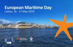
Chief executive Dr Peter Heffernan is representing the Marine Institute at European Maritime Day 2019 in Lisbon, Portugal this week.

Concluding today, Friday 17 May, European Maritime Day is one of the largest marine science and policy meetings of the year.

The 2019 programme focuses on blue entrepreneurship, research, innovation and investment to transform traditional maritime sectors and boost emerging technologies.

Dr Heffernan said the Marine Institute “plays a crucial role in supporting, co-ordinating and promoting marine research at a national and international level.

“By working alongside academic institutions in Ireland, and participating in and leading research partnerships, the institute is able to increase our knowledge of the ocean which will assist in the sustainable management and development of our marine resource.”

The Galway Statement, signed at the Marine Institute in 2013, provided the first step in forming the Atlantic Ocean Research Alliance (AORA) between the European Union, Canada and the United States of America.

AORA aims to promote a healthier Atlantic Ocean, find more sustainable ways to use its resources and increase people’s awareness and literacy surrounding the ocean.

“AORA is science diplomacy at work,” Dr Heffernan said. “Transatlantic cooperation has been instrumental to the success of AORA and creating a strong Atlantic community.

“Within five years, scientific research teams working together in the Atlantic have unearthed new discoveries and knowledge in the areas of seabed mapping, ocean observation, climate and polar research, and marine biotechnology.”

European Maritime Day encourages a ‘blue economy revolution’ to deliver economic growth in the maritime sector and expand employment opportunity.

The programme covers almost all aspects of marine science, technology and policy, and encourages participants to engage with partners from the EU community to exchange information.

The 2020 European Maritime Day annual meeting will be hosted by Cork City Council, which will mark the first time Ireland has hosted the event.

Published in Marine Science

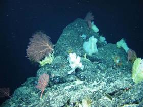
#MarineScience - A multinational team of ocean exploration experts returned to Galway on World Ocean Day (Friday 8 June) after spending the last few weeks exploring and mapping the Charlie-Gibbs Fracture Zone of the Mid-Atlantic Ridge.

Using the robotic mini-sub ROV Holland I, the TOSCA (Tectonic Spreading and the Charlie-Gibbs Fracture Zone) research team led by Dr Aggie Georgiopoulou of UCD collected “spectacular” film footage of sponge gardens.

In another first for deep-sea exploration, the marine science team on board the RV Celtic Explorer also found more than 70 skate eggs in a nursery some 2,000 metres below the surface.

“Up to 150 rock and sediment samples amounting to roughly 200kg along with 86 hours of video footage and over 10,000 square kilometres of the zone were also mapped, which is almost the size of Co Galway and Co Mayo together,” Dr Georgiopoulou said.

The Charlie-Gibbs Fracture Zone was mapped for the first time in 2015 on the RV Celtic Explorer as one of the key projects launched by the Atlantic Ocean Research Alliance, following the signing of the Galway Statement on Atlantic Ocean Cooperation between Canada, the EU and the US in May 2013.

“The high resolution data produced by Ireland’s INFOMAR programme in 2015, that revealed spectacular landscape with 4,000m-high mounds rising from the seabed to 600m below the sea surface — taller than Carrauntoohil, Ireland’s highest mountain — has been instrumental in our continued research over the last month,” Dr Georgiopoulou said.

The tectonic spreading at the Charlie-Gibbs Fracture Zone consists of two huge parallel cracks in the crust of the Atlantic Ocean running between Ireland and Newfoundland, and is the longest-lived fracture zone in the Atlantic. It is the most prominent feature interrupting and offsetting the Mid-Atlantic Ridge.

“What we have found at the Charlie-Gibbs Fracture Zone surpassed all of our expectations,” Dr Georgiopoulou added. “Exploring three mountain areas, 500-1,000m-high scarps were discovered that have been produced by catastrophic rock avalanches, with giant boulder fields spilling into the fractures.

“Although these fracture zones are similar to the San Andreas fault in the western US and the North Anatolian fault in Turkey and Greece, with large earthquakes taking place there regularly, this is the first time there has been a dedicated geological study in the Charlie-Gibbs Fracture Zone area.”

The TOSCA expedition involved 13 scientists from nine institutions and five different countries including Ireland, the UK, Germany, Canada and Greece.

Experts in seabed mapping, marine geology, oceanography and marine biology, each team will return to their respective Institutes to analyse all the data and work out how the mountains were formed, when and how the rock avalanches take place and how the geology affects the local habitat for marine wildlife.

Marine Institute chief executive Dr Peter Heffernan congratulated the team on their recent discoveries, stating that deep ocean expeditions cannot be taken for granted as we need to better understand the features that make up the ocean seabed.

“With the ocean affecting climate change, global population and seafood demand, we need to map our seabed to define favourable habitats for fishing, key sites for conservation, and safe navigation for shipping.

“The expedition supported by AORA also reflects the value and essential role of international partnerships, particularly with achieving the shared goals of the Galway Statement on Atlantic Ocean Cooperation 2013, which include our ongoing cooperation on ocean science and observation in the Atlantic Ocean,” Dr Heffernan said.

Published in Marine Science

#MarineScience - Five years ago this month, the Galway Statement on Atlantic Ocean Cooperation was signed and the Atlantic Ocean Research Alliance (AORA) between the European Union, Canada and the United States of America formed.

In the time since, the AORA has already been recognised as a success story in the Atlantic area, highlighting international best practices, and promoting the key priorities of the European Union’s Atlantic Strategy and Atlantic Action Plan, embodied in the Galway Statement and its potential support to the Blue Economy.

Today there are more than 500 research teams working in the Atlantic Ocean. Transatlantic co-operation has been embedded and embraced at the heart of the scientific teams working together in Atlantic-wide field campaigns on seabed mapping, ocean observation, seafood, weather, climate and polar research, marine biotechnology and marine spatial planning.

The Galway Statement has also provided the first step in all-Atlantic co-operation, leading to the signing of the Belém Statement on Atlantic Research & Innovation Cooperation between the European Union, South Africa and Brazil. An all-Atlantic research community is also being built.

New transatlantic institutional structures have been formed, including an Ocean Frontier Institute in Canada which includes European and US partners.

Speaking about the achievements to date, Dr Margaret Rae, director of AORA co-ordination and support action at the Marine Institute, said: “AORA is using the latest technology to map the Atlantic, making groundbreaking discoveries like previously uncharted undersea volcanoes and mountains, circulation patterns, and more.

“Our coordinated efforts are helping to create a blueprint for the next generation of ocean observation. And there’s still much to uncover, from new sources of energy and food to lifesaving medicines found in unexpected sources.

“By learning all we can about our oceans, we can create a world with better navigation, weather prediction, smarter search and rescue, health, and a thriving seafood industry that will feed generations to come.”

Transatlantic research teams with Horizon 2020 funding have unearthed new discoveries and knowledge:

Seabed Mapping
- Completed seven opportunistic transatlantic surveys by Irish, Canadian, French and Fugro vessels, resulting in discoveries of uncharted seamounts kilometres high, deep sea volcanoes, and ridges some hundreds of kilometres in length.
- Developed a collaborative model for industry, research and government to promote Atlantic seabed mapping and open data.
- Encouraged private sector participation for public good, resulting in Fugro contributing more than 65,000 sq km of high resolution data. Fugro maps the seabed while transiting between offshore projects.

Ocean Observation
- Completed an analysis of Atlantic-wide observation system capacities/gaps.
- For the first time a team has formed to develop a blueprint for an Atlantic-wide integrated ocean observing system with wide Atlantic participation.

Atlantic Ecosystems
- Co-ordinated expeditions to map deep-sea Atlantic ecosystems and advanced knowledge of key species, ecosystems and processes.
- Discovered modern Atlantic Ocean circulation which is atypical of the longer term.
- Deployed new sensors in eastern subpolar North Atlantic to enable key advancements in understanding of ocean physics interactions.
- Provided scientific evidence that temperature change, acidification, fisheries and their cumulative effects pose the greatest risks to ecosystem services.
- Successfully tested a generic Marine Spatial Planning (MSP) framework to assess spatially managed areas (SMAs) across the North Atlantic.

Seafood
- For the first time, climate vulnerability assessments of North Atlantic fish and shellfish, including the human communities dependent on these have been rigorously compared across the EU, US & Canada – strengthening scientific cooperation and building better forecasts.
- Made the first steps to use marine algae to build ‘blue belts’ for carbon/nitrogen sequestration and sustainable aquaculture.

Ocean Education
- Developed a transatlantic ocean literacy strategy and a range of new ocean educational materials (videos, teaching modules, infographics).

Weather, Climate & Polar Research
- Worked together to study Arctic warming impacts, ecosystem productivity and ocean-climate dynamics to give new understanding to local populations.
- Facilitated co-operative understanding of the impact of a changing Arctic on weather and climate across the northern hemisphere.
- Worked with public and private users of climate information to help them incorporate uncertain scientific evidence into real-world decision-making processes.

For more information see www.atlanticresource.org.

Published in Marine Science

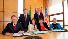
#MarineScience - Canada’s Minister of Environment and Climate Change, Catherine McKenna, was at the Marine Institute headquarters in Oranmore yesterday (Friday 13 October) to discuss collaborations under the Atlantic Ocean Research Alliance.

The Marine Institute meetings were part of a tour by Minister McKenna to London and Dublin to advance discussions on clean growth and climate action.

Minister McKenna was accompanied by Canadian Ambassador to Ireland Kevin Vickers and met with the Marine Institute’s chair Dr John Killen and chief executive Dr Peter Heffernan, members of the senior management team and scientific staff.

The meeting provided an opportunity to discuss existing projects and opportunities to further Ireland and Canada’s collaboration on Atlantic Ocean research and climate impacts.

“Transatlantic cooperation is essential to broadening our scientific understanding of the Atlantic Ocean and helping to ensure it remains healthy and productive,” said Dr Heffernan. “It’s hugely important for Ireland and brings us closer to achieving the goals of the Galway Statement on Atlantic Ocean Co-operation signed here at the Marine Institute Galway in May 2013 by the EU, USA and Canada.

“The goal is to work together, share expertise and advance our science goals to promote the sustainable management of our Atlantic ocean for the benefit of all.”

Since the signing of the Galway Statement, the Marine Institute says it has led initiatives to further this collaboration in areas including Atlantic seabed mapping and climate change research, and is leading the EU H2020-funded Atlantic Ocean Research Alliance - Coordination and Support Action.

Speaking on her visit to the Marine Institute, Minister McKenna said: “Canada and Ireland are natural partners on marine research. Canada recognises that Atlantic research will be more effective if we work together and on both sides of the ocean.

“The knowledge we gain benefits us all, and all and is crucial to helping us to meet the challenges we face, in particular climate change, food security and new sources of energy.”

Ambassador Vickers added: “We are now entering a new era of transatlantic co-operation that will enable us to achieve great things together in the coming years.

“We are raising the importance for ocean discovery above sectoral interests and putting marine research on a new global level that transcends national borders, making literal the bonds connecting Ireland and Canada, to increase our knowledge of the ocean that joins us and to maximise the innovation potential it affords us.”

Published in Marine Science

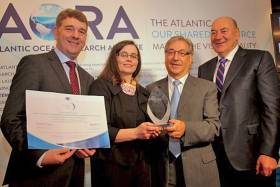
#MarineScience - The Atlantic Ocean Research Alliance Co-ordination and Support Action (AORA-CSA) has received the first Atlantic Project Award for International Cooperation.

The Marine Institute-led project was presented with the accolade yesterday (Tuesday 27 September) during the Atlantic Stakeholders Conference at the Croke Park Conference Centre.

Karmenu Vella, European Commissioner for Environment, Maritime Affairs and Fisheries, presented the award to Dr Peter Heffernan and Dr Margaret Rae of the Marine Institute, the lead partner in the Horizon 2020-funded project to implement the Galway Statement on Atlantic Ocean co-operation and support the emerging blue economy.

Marine Minister Michael Creed highlighted the importance of the Atlantic Strategy to Ireland in his address to the conference, which aims to promote entrepreneurship and innovation as a hub for participants to make valuable contacts and explore areas for co-operation, share information and good practices, promote and identify new ideas as well as funding opportunities and partnerships for their projects.

"Just over half of the 400-plus delegates at the conference today are Irish, many of them SMEs, which shows the importance of the Atlantic Strategy to Ireland and the significant opportunities it represents,” said Dr Heffernan, the Marine Institute’s chief executive.

“Irish SMEs have the chance to meet face to face with potential research partners and investors, and to work together on ideas for novel marine projects at the networking and matchmaking activities here today.”

The Atlantic Strategy has influence on the European Union’s innovation and funding programmes, including the Horizon 2020 framework programme for research, the European Maritime and Fisheries Fund (EMFF) and the InterReg programme.

"Irish marine researchers have been very successful in winning blue growth research funding, with 5% of the available budget under Horizon 2020 in 2014 going to Irish researchers,” said Dr Heffernan. “Irish marine research projects benefitted from €5.6m funding and resulted in the creation of about 41 research jobs.

"Irish researchers had an equally strong performance in 2015, winning €2.86m in competitive funding, representing 4.7% of the total EU budget in this area."

Seven Irish research organisations were funded under the 2015 calls, with NUI Galway winning nearly €1m for a number of marine research projects.

Another notable Irish success was Brandon Bioscience Ltd, funded under the SME instrument as partners in the SEA MORE YIELD project to commercialise a novel biotech solution to yield losses in oil seed crops using native Irish seaweed.

The Atlantic Strategy Group, which oversees the implementation of the EU's Atlantic Strategy, is currently chaired by Ireland and made up of relevant member states (Ireland, UK, France, Portugal, and Spain), the European Parliament and the European Commission, as well as regional representatives.

Published in Marine Science

#BlueGrowth - The first projects funded under the EU's Horizon 2020 programme for 'blue growth' will be launched at a conference in Brussels next month.

The Atlantic - Our Shared Resource: Making the Vision Reality will be held at the Palais d'Egmont from 16-17 April.

It marks a "new exciting stage" in implementation of activities signposted in 2013's Galway Statement on Atlantic Ocean Co-operation.

And it's sure to inform the discussions at this July's Harnessing Our Ocean Wealth Conference in Cork Harbour.

Details on registration for the conference are available HERE.

Published in News Update

#MarineScience - The Atlantic Ocean: Our Unknown Treasure was on the agenda at the annual meeting of the American Association for the Advancement of Science (AAAS) in San Jose, California on Saturday 14 February.

Marine Institute chief executive Dr Peter Heffernan joined European Commission officials and leading scientists from the USA, Europe and Canada to discuss how to explore the largely unknown Atlantic Ocean; how new technologies can help us to challenge our understanding of the planet; and how new observation and visualisation tools can improve what we know about the seabed and inform science to help shape future marine policy.

The event built on the Galway Statement on Atlantic Ocean Research Co-operation signed at the Marine Institute in May 2013 by representatives from the EU, Canada and the US, launching an Atlantic Ocean Research Alliance.

Its goals are to better understand the Atlantic and the Arctic, to study the interplay between them, particularly relating to climate change, and to promote sustainable management of their resources.

Speaking about the event, Dr Heffernan said: "It's an exciting time, as all sides - European, US and Canadian - have shown engagement, planning and commitment to driving the Atlantic Ocean Research Alliance forward and preparing joint actions.

"There are very real global challenges to be tackled, and there is strong momentum now to create significant benefits such as better ecosystem assessments and forecasts and deeper understandings of vulnerabilities and risks.

"These transatlantic collaborations will also help to generate new tools to increase resilience and adaptation and to conserve our rich biodiversity. We also really need to foster public understanding of how ocean science and observation will address pressing issues for citizens and for the environment."

Dr Heffernan concluded: "The AAAS meeting gave an opportunity to see some of the collaborations that are undertaken in the Atlantic Ocean and discuss challenges for future research, technological developments, mapping and imaging as well as research co-operation across the Atlantic."

Published in Marine Science

General Information on using Waterways Ireland inland navigations

Safety on the Water

All users of the navigations are strongly recommended to make themselves aware of safety on the water for whatever activity they are involved in and to read the advice offered by the various governing bodies and by:

The Dept. of Transport, Ireland: www.gov.ie/transport and The Maritime and Coastguard Agency, UK, The RNLI – Water Safety Ireland for information in terms of drowning prevention and water safety.

Registration of Vessels

All vessels using the Shannon Navigation, which includes the Shannon-Erne Waterways and the Erne System must be registered with Waterways Ireland. Only open undecked boats with an engine of 15 horsepower or less on the Shannon Navigation, and vessels of 10 horsepower or less on the Erne System, are exempt. Registration is free of charge.

Craft registration should be completed online at: https://www.waterwaysireland.org/online-services/craft-registration

Permits for use of the Grand and Royal Canals and the Barrow Navigation

All vessels using the Grand and Royal Canals and the Barrow Navigation must display appropriate valid Permit(s) i.e A Combined Mooring and Passage Permit (€126) and if not intending to move every five days, an Extended Mooring Permit (€152).

Permit applications should be completed online at: https://www.waterwaysireland.org/online-services/canal-permits

Passage on the Royal and Grand Canals – Dublin Area

For boat passage through the locks east of Lock 12 into / out of Dublin on either the Royal or Grand Canals, Masters are requested to contact the Waterways Ireland Eastern Regional Office (M-F 9.30am-4.30pm) on tel: +353(0)1 868 0148 or email [email protected] prior to making passage in order to plan the necessary lock-keeping assistance arrangements.

On the Grand Canal a minimum of two days notice prior to the planned passage should be given, masters should note that with the exception of pre-arranged events, a maximum of 2 boats per day will be taken through the locks, travelling either east or west.

Movements in or out of the city will be organised by prior arrangement to take place as a single movement in one day. Boaters will be facilitated to travel the system if their passage is considered to be safe by Waterways Ireland and they have the valid permit(s) for mooring and passage.

Newcomen Lifting Bridge

On the Royal Canal two weeks’ notice of bridge passage (Newcomen Lifting Bridge) is required for the pre-set lift date, and lock assistance will then also be arranged. A minimum of 2 boats is required for a bridge lift to go ahead.

Waterways Ireland Eastern Regional Office (Tel: +353(0)1 868 0148 or [email protected] ) is the point of contact for the bridge lift.

A maximum number of boats passing will be implemented to keep to the times given above for the planned lifts (16 for the Sat / Sun lifts & 8 for the weekday lifts). Priority will be given on a first come first served basis.

On day of lift, boaters and passengers must follow guidance from Waterways Ireland staff about sequence of passage under bridge & through Lock 1, and must remain within signed and designated areas.

Events Held on the Waterways

All organised events taking place on the waterways must have the prior approval of Waterways Ireland. This is a twelve week process and application forms must be accompanied with the appropriate insurance, signed indemnity and risk assessment. The application should be completed on the Waterways Ireland events page at :

https://www.waterwaysireland.org/online-services/event-approval

Time Limits on Mooring in Public Harbours

On the Shannon Navigation and the Shannon-Erne Waterway craft may berth in public harbours for five consecutive days or a total of seven days in any one month.

On the Erne System, revised Bye Laws state that: No master or owner shall permit a vessel, boat or any floating or sunken object to remain moored at or in the vicinity of any public mooring, including mooring at any other public mooring within 3 kilometres of that location, for more than 3 consecutive days and shall not moor at that same mooring or any other public mooring within 3 kilometres of that location within the following 3 consecutive days without prior permission by an authorised official.

Winter Mooring on the Shannon Navigation and Shannon Erne Waterway

Winter mooring may be availed of by owners during the period 1 Nov to 31 Mar by prior arrangement and payment of a charge of €63.50 per craft. Craft not availing of Winter Mooring must continue to comply with the “5 Day Rule”. Winter Mooring applications should be completed online at : https://www.waterwaysireland.org/online-services/winter-moorings-booking

Owners should be aware that electricity supply and water supply to public moorings is disconnected for the winter months. This is to protect against frost damage, to reduce running costs and to minimise maintenance requirements during the winter months.

Vessel owners are advised that advance purchasing of electricity on the power bollards leading up to the disconnection date should be minimal. Electricity credit existing on the bollards will not be recoverable after the winter decommissioning date. Both services will be reinstated prior to the commencement of the next boating season.

Smart Cards

Waterways Ireland smart cards are used to operate locks on the Shannon Erne Waterway, to access the service blocks, to use the pump-outs along the navigations, to avail of electrical power at Waterways Ireland jetties.

Berthing in Public Harbours

Masters are reminded of the following:

  • Equip their vessel with mooring lines of appropriate length and strength and only secure their craft to mooring bollards and cleats provided for this purpose.
  • Ensure the available berth is suitable to the length of your vessel, do not overhang the mooring especially on finger moorings on floating pontoon moorings.
  • Ensure mooring lines, electric cables and fresh water hoses do not create a trip hazard on public jetties for others users.
  • Carry sufficient fenders to prevent damage to your own vessel, other vessels and WI property.
  • Allow sufficient space between your vessel and the vessel ahead /astern (c.1m) for fire safety purposes and /or to recover somebody from the water.
  • Do not berth more than two vessels side by side and ensure there is safe access/egress at all times between vessels and onto the harbour itself.
  • Do not berth in such a way to prevent use of harbour safety ladders, slipways or pump-outs.
  • Do not allow the bow of your vessel to overhang the walkway of a floating mooring thus creating a hazard for others with an overhanging anchor or bow fendering.
  • Animals are not allowed to be loose or stray at any time.
  • Harbour and jetty infrastructure such as railings, power pedestals, fresh water taps, electric light poles, safety bollards, ladders etc are not designed for the purpose of mooring craft , they will not bear the strain of a vessel and will be damaged.
  • At Carrybridge on the Erne System, Masters of vessels are not permitted to use stern on mooring. Masters of vessels must use the mooring fingers for mooring of vessels and for embarkation / disembarkation from vessels.

Passenger Vessel Berths

Masters of vessels should not berth on passenger vessel berths where it is indicated that an arrival is imminent. Passenger vessels plying the navigations generally only occupy the berths to embark and disembark passengers and rarely remain on the berths for extended periods or overnight.

Lock Lead-in Jetties

Lead-in jetties adjacent to the upstream and downstream gates at lock chambers are solely for the purpose of craft waiting to use the lock and should not be used for long term berthing.

Vessel Wake

Vessel wake, that is, the wave generated by the passage of the boat through the water, can sometimes be large, powerful and destructive depending on the hull shape and engine power of the vessel. This wake can be detrimental to other users of the navigation when it strikes their craft or inundates the shoreline or riverbank. Masters are requested to frequently look behind and check the effect of their wake / wash particularly when passing moored vessels, on entering harbours and approaching jetties and to be aware of people pursuing other activities such as fishing on the riverbank.

Speed Restriction

A vessel or boat shall not be navigated on the Shannon Navigation at a speed in excess of 5 kph when within 200 metres of a bridge, quay, jetty or wharf, when in a harbour or canal or when passing within 100 metres of a moored vessel or boat.

Vessels navigating the Shannon-Erne Waterway should observe the general 5 kph speed limit which applies along the waterway. This is necessary in order to prevent damage to the banks caused by excessive wash from vessels.

Vessels navigating the Erne System should observe the statutory 5kt / 6mph / 10kph speed limit areas.

A craft on the Royal and Grand canals shall not be navigated at a speed in excess of 6km per hour.

A craft on the Barrow Navigation shall not be navigated at a speed in excess of 11km per hour except as necessary for safe navigation in conditions of fast flow.

Bank Erosion

Narrow sections of all the navigations are particularly prone to bank erosion due to the large wash generated by some craft. Masters are requested to be vigilant and to slow down to a speed sufficient to maintain steerage when they observe the wash of their craft inundating the river banks.

Unusual Waterborne Activity

Unusual waterborne vessels may be encountered from time to time, such as, hovercraft or amphibious aircraft / seaplanes. Masters of such craft are reminded to apply the normal “Rule of the Road” when they meet conventional craft on the water and to allow extra room to manoeuvre in the interest of safety.

Sailing Activity

Mariners will encounter large numbers of sailing dinghies from late June to August in the vicinity of Lough Derg, Lough Ree and Lower Lough Erne. Sailing courses are marked by yellow buoys to suit weather conditions on the day. Vessels should proceed at slow speed and with due caution and observe the rules of navigation when passing these fleets, as many of the participants are junior sailors under training.

Rowing

Mariners should expect to meet canoes and vessels under oars on any part of the navigations, but more so in the vicinity of Athlone, Carrick-on-Shannon, Coleraine, Enniskillen and Limerick. Masters are reminded to proceed at slow speed and especially to reduce their wash to a minimum when passing these craft as they can be easily upset and swamped due to their very low freeboard and always be prepared to give way in any given traffic situation.

Canoeing

Canoeing is an adventure sport and participants are strongly recommended to seek the advice of the sport’s governing bodies i.e Canoeing Ireland and the Canoe Association of Northern Ireland, before venturing onto the navigations.

Persons in charge of canoes are reminded of the inherent danger to these craft associated with operating close to weirs, sluice gates, locks and other infrastructure particularly when rivers are in flood and large volumes of water are moving through the navigations due to general flood conditions or very heavy localised precipitation e.g. turbulent and broken water, stopper waves. Shooting weirs is prohibited without prior permission of Waterways Ireland.

Canoeists should check with lockkeepers prior entering a lock to ensure passage is done in a safe manner. Portage is required at all unmanned locks.

Canoe Trail Network – "Blueways"

Masters of powered craft are reminded that a canoe trail network is being developed across all navigations and to expect more organised canoeing along these trails necessitating slow speed and minimum wash when encountering canoeists, rowing boats etc

Rockingham and Drummans Island Canals – Lough Key

It is expected that work on Rockingham and Drummans Island Canals on Lough Key will be completed in 2021. Access to these canals will be for non-powered craft only, eg canoes, kayaks, rowing boats.

Fast Powerboats and Personal Watercraft (Jet Skis)

Masters of Fast Powerboats (speed greater than 17kts) and Personal Watercraft (i.e.Jet Skis) are reminded of the inherent dangers associated with high speed on the water and especially in the confines of small bays and narrow sections of the navigations. Keeping a proper look-out, making early alterations to course and /or reducing speed will avoid conflict with slower vessels using the navigation. Personal Watercraft are not permitted to be used on the canals.

Towing Waterskiers, Wakeboarders, Doughnuts etc

Masters of vessels engaged in any of these activities are reminded of the manoeuvring constraints imposed upon their vessel by the tow and of the added responsibilities that they have to the person(s) being towed. These activities should be conducted in areas which are clear of conflicting traffic. It is highly recommended that a person additional to the master be carried to act as a “look-out” to keep the tow under observation at all times.

Prohibition on Swimming

Swimming in the navigable channel, particularly at bridges, is dangerous and is prohibited due to the risk of being run over by a vessel underway in the navigation.

Age Restrictions on operating of powered craft

In the Republic of Ireland, Statutory Instrument 921 of 2005 provides the legal requirements regarding the minimum age for operating of powered craft. The Statutory Instrument contains the following requirements:

- The master or owner of a personal watercraft or a fast power craft shall take all reasonable steps to ensure that a person who has not attained the age of 16 years does not operate or control the craft

- The master or owner of a pleasure craft powered by an engine with a rating of more than 5 horse power or 3.7 kilowatts shall take all reasonable steps to ensure that a person who has not attained the age of 12 years does not operate or control the craft.

Lifejackets and Personal Flotation Devices (PFDs)

Lifejackets and PFD’s are the single most important items of personal protective equipment to be used on a vessel and should be worn especially when the vessel is being manoeuvred such as entering / departing a lock, anchoring, coming alongside or departing a jetty or quayside.

In the Republic of Ireland, Statutory Instrument 921 of 2005 provides the legal requirements regarding the wearing of Personal Flotation Devices. The Statutory Instrument contains the following requirements:

- The master or owner of a pleasure craft (other than a personal watercraft) shall ensure, that there are, at all times on board the craft, sufficient suitable personal flotation devices for each person on board.

- A person on a pleasure craft (other than a personal watercraft) of less than 7 metres length overall shall wear a suitable personal flotation device while on board an open craft or while on the deck of decked craft, other than when the craft is made fast to the shore or at anchor.

- The master or owner of a pleasure craft (other than a personal watercraft) shall take all reasonable steps to ensure that a person who has not attained the age of 16 years complies with paragraph above.

- The master or owner of a pleasure craft (other than a personal watercraft), shall take all reasonable steps to ensure that a person who has not attained the age of 16 years wears a suitable personal flotation device while on board an open craft or while on the deck of a decked craft other than when it is made fast to the shore or at anchor.

- The master or owner of a pleasure craft (other than a personal watercraft) shall take all reasonable steps to ensure that a person wears a suitable personal flotation device, at all times while – (a) being towed by the craft, (b) on board a vessel or object of any kind which is being towed by the craft.

Further information is available at: http://www.irishstatutebook.ie/eli/2005/si/921/made/en/print

Firing Range Danger Area – Lough Ree

The attention of mariners is drawn to the Irish Defence Forces Firing Range situated in the vicinity of buoys No’s 2 and 3, on Lough Ree on the Shannon Navigation. This range is used regularly for live firing exercises, throughout the year, all boats and vessels should stay clear of the area marked with yellow buoys showing a yellow "X" topmark and displaying the word "Danger".

Shannon Navigation, Portumna Swing Bridge Tolls

No attempt should be made by Masters’ of vessels to pay the bridge toll while making way through the bridge opening. Payment will only be taken by the Collector from Masters when they are secured alongside the jetties north and south of the bridge.

Navigating from Killaloe to Limerick on the Shannon Navigation

The navigation from Killaloe to Limerick involves passage through Ardnacrusha locks, the associated headrace and tailrace and the Abbey River into Limerick City. Careful passage planning is required to undertake this voyage. Considerations include: lock passage at Ardnacrusha, water flow in the navigation, airdraft under bridges on Abbey River in Limerick, state of tide in Limerick

Users are advised to contact the ESB Ardnacrusha hydroelectric power station (00353 (0)87 9970131) 48 hours in advance of commencing their journey to book passage through the locks at Ardnacrusha. It is NOT advised to undertake a voyage if more than one turbine is operating (20MW), due to the increased velocity of flow in the navigation channel, which can be dangerous. To ascertain automatically in real time how many turbines are running, users can phone +353 (0)87 6477229.

For safety reasons the ESB has advised that only powered craft with a capacity in excess of 5 knots are allowed to enter Ardnacrusha Headrace and Tailrace Canals.

Passage through Sarsfield Lock should be booked on +353-87-7972998, on the day prior to travel and it should be noted also that transit is not possible two hours either side of low water.

A Hydrographic survey in 2020 of the navigation channel revealed that the approach from Shannon Bridge to Sarsfield Lock and the Dock area has silted up. Masters of vessels and water users are advised to navigate to the Lock from Shannon bridge on a rising tide one or two hours before High Tide.

Lower Bann Navigation

The attention of all users is drawn to the “Users Code for the Lower Bann”, in particular to that section covering “Flow in the River” outlining the dangers for users both on the banks and in the navigation, associated with high flow rates when the river is in spate. Canoeists should consult and carry a copy of the “Lower Bann Canoe Trail” guide issued by the Canoe Association of Northern Ireland. Users should also contact the DfI Rivers Coleraine, who is responsible for regulating the flow rates on the river, for advisory information on the flow rates to be expected on any given day.

DfI Rivers Coleraine. Tel: 0044 28 7034 2357 Email: [email protected]

Lower Bann Navigation – Newferry – No wake zone

A No Wake Zone exists on the Lower Bann Navigation at Newferry. Masters of vessels are requested to proceed at a slow speed and create no wake while passing the jetties and slipways at Newferry.

Overhead Power Lines (OHPL) and Air draft

All Masters must be aware of the dangers associated with overhead power lines, in particular sailing vessels and workboats with cranes or large air drafts. Voyage planning is a necessity in order to identify the location of overhead lines crossing the navigation.

Overhead power line heights on the River Shannon are maintained at 12.6metres (40 feet) from Normal Summer level for that section of navigation, masters of vessels with a large air draft should proceed with caution and make additional allowances when water levels are high.

If a vessel or its equipment comes into contact with an OHPL the operator should NOT attempt to move the vessel or equipment. The conductor may still be alive or re-energise automatically. Maintain a safe distance and prevent third parties from approaching due to risk of arcing. Contact the emergency services for assistance.

Anglers are also reminded that a minimum ground distance of 30 metres should be maintained from overhead power lines when using a rod and line.

Submarine Cables and Pipes

Masters of vessels are reminded not to anchor their vessels in the vicinity of submarine cables or pipes in case they foul their anchor or damage the cables or pipes. Look to the river banks for signage indicating their presence.

Water Levels - Precautions

Low Water Levels:

When water levels fall below normal summer levels masters should be aware of:

Navigation

To reduce the risk of grounding masters should navigate on or near the centreline of the channel, avoid short cutting in dog-legged channels and navigating too close to navigation markers.

Proceeding at a slow speed will also reduce “squat” effect i.e. where the vessel tends to sit lower in the water as a consequence of higher speed.

Slipways

Reduced slipway length available under the water surface and the possibility of launching trailers dropping off the end of the concrete apron.

More slipway surface susceptible to weed growth requiring care while engaged in launching boats, from slipping and sliding on the slope. Note also that launching vehicles may not be able to get sufficient traction on the slipway once the craft is launched to get up the incline.

Bank Erosion

Very dry riverbanks are more susceptible to erosion from vessel wash.

Lock Share

Maximising on the number of vessels in a lock will ensure that the total volume of water moving downstream is decreased. Lock cycles should be used for vessels travelling each way.

High Water Levels:

When water levels rise above normal summer level masters should be aware of:

Navigation

Navigation marks will have reduced height above the water level or may disappear underwater altogether making the navigable channel difficult to discern.

In narrow sections of the navigations water levels will tend to rise more quickly than in main streams and air draft at bridges will likewise be reduced.

There will also be increased flow rates particularly in the vicinity of navigation infrastructure such as bridges, weirs, locks etc where extra care in manoeuvring vessels will be required.

Harbours and Jetties

Due care is required in harbours and at slipways when levels are at or near the same level as the harbour walkways' as the edge will be difficult to discern especially in reduced light conditions. It is advised that Personal Flotation Devices be worn if tending to craft in a harbour in these conditions.

Slipways

Slipways should only be used for the purpose of launching and recovering of water craft or other objects from the water. Before using a slipway it should be examined to ensure that the surface has sufficient traction/grip for the intended purpose such as launching a craft from a trailer using a vehicle, that there is sufficient depth of water on the slipway to float the craft off the trailer before the concrete apron ends and that the wheels of the trailer do not drop off the edge of the slipway. That life-saving appliances are available in the vicinity, that the vehicle is roadworthy and capable of coping with the weight of the trailer and boat on the incline. It is recommended that slipway operations are conducted by two persons.

Caution to be Used in Reliance upon Aids to Navigation

The aids to navigation depicted on the navigation guides comprise a system of fixed and floating aids to navigation. Prudent mariners will not rely solely on any single aid to navigation, particularly a floating aid to navigation. With respect to buoys, the buoy symbol is used to indicate the approximate position of the buoy body and the ground tackle which secures it to the lake or river bed. The approximate position is used because of the practical limitations in positioning and maintaining buoys in precise geographical locations. These limitations include, but are not limited to, prevailing atmospheric and lake/river conditions, the slope of and the material making up the lake/river bed, the fact that the buoys are moored to varying lengths of chain, and the fact that the buoy body and/or ground tackle positions are not under continuous surveillance. Due to the forces of nature, the position of the buoy body can be expected to shift inside and outside the charted symbol.

Buoys and perches are also moved out of position or pulled over by those mariners who use them to moor up to instead of anchoring. To this end, mariners should always monitor their passage by relating buoy/perch positions with the published navigation guide. Furthermore, a vessel attempting to pass close by always risks collision with a yawing buoy or with the obstruction that the buoy or beacon/perch marks.

Masters of Vessels are requested to use the most up to date Navigation guides when navigating on the Inland Waterways.

Information taken from Special Marine Notice No 1 of 2023