Menu

Ireland's sailing, boating & maritime magazine

Inland afloat headers


Displaying items by tag: Haulbowline Island

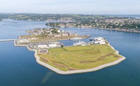
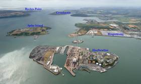
One year on since completion, the Haulbowline Island Recreational Amenity in the heart of Cork Harbour is the largest project of its kind to date in Ireland.

The Haulbowline Remediation by Cork County Council has transformed the former East Tip site into a 22-acre People’s Park in the middle of the Harbour.

And, as we celebrate the first anniversary of the park, Afloat's 'before' aerial photos below show what an amazing transformation has been carried out by Cork County Council. 

650,000 cubic metres of by-products from steel production were deposited here over a 40-year period
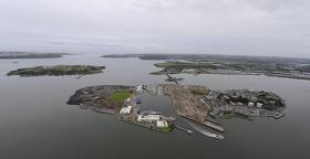
650,000 cubic metres of by-products from steel production were deposited here over a 40-year period Photos: Bob Bateman

Haulbowline, home to the headquarters of the Irish Naval Service, was also formerly the location of Ireland’s only steelworks from 1939 until its closure in 2001. 650,000 cubic metres of by-products from the steel production was deposited here over a 40-year period.

The extensive remediation of the site saw the delivery onto the island of over 15,000 HGV loads of material, 47,000 tonnes of rock armour material to protect the shoreline, 180,000 tonnes of subsoil and 37,000 tonnes of topsoil, transforming the site into the scenic landscaped recreational amenity it is today.

As Afloat previously reported, complete with 4kms of fully accessible pathways, a 1 km jogging circuit, playing pitches and seating areas that lend themselves to remarkable views of the harbour and wildlife observation, the island has hundreds of native tree mixes and plants to promote biodiversity.

Published in Cork Harbour

A former Cork Harbour slagheap turned park has been officially opened by the Taoiseach, as The Irish Times reports.

Taoiseach Micheál Martin was joined by local TD and Defence Minister Simon Coveney among others on Saturday (17 July) at the ribbon-cutting for what’s been named the People’s Park Haulbowline.

As previously reported on Afloat.ie, the park — on the site of the former Irish Steel slag heap at the east tip of Haulbowline island — includes 4km of harbour-side walkways, a 1km jogging circuit and numerous seating areas.

It has also been extensively landscaped with wildflower areas and more than 200 trees, rich with biodiversity and wildlife.

And its official opening marks the culmination of a multi-year, €25m remediation project that the Taoiseach says should stand as a model for the rest of the country.

“This is great day not for Corkonians but also for the people of Ireland,” he said. “It’s a national people’s park but it also reflects the genuine transformation that we can bring about at various sites.”

The Irish Times has more on the story HERE.

Bob Bateman's People's Park & Haulbowline Photo Gallery

Published in Cork Harbour

Haulbowline Island Amenity Park in Ringaskiddy will be open to the public from tomorrow, Friday 15 January, Co Cork’s mayor has confirmed.

The park includes 4km of harbour-side walkways, a 1km jogging circuit and numerous seating areas to stop and take in the views of Cork Harbour.

It has also been extensively landscaped with wildflower areas and more than 200 trees, and is rich with biodiversity and wildlife.

Mayor of the County of Cork, Cllr Mary Linehan Foley welcomed the opening of the park and noted the value of safe areas for outdoor recreation, which are especially welcome at these times.

“Covid-19 restrictions have seen a huge uptake in people using our parks, beaches and greenways to get exercise within their 5km,” she said.

“Haulbowline Island Amenity Park will be a fantastic asset, particularly to the people of Ringaskiddy and the immediate surrounding area.

“People living outside 5km from the park will have to wait to visit Haulbowline but it will be worth the wait for the spectacular views of Cork Harbour.”

Cork County Council chief executive Tim Lucey noted the level of transformation that has taken place in the development of the park.

“The most innovative and customised solutions have been applied throughout with spectacular end results: excellent amenities and the establishment of woodlands and wildflower areas,” he said.

A spokesperson for Ringaskiddy and District Residents Association welcomed the opening of the park and highlighted the value of this amenity to local residents noting that “any environmentally-friendly recreational amenities are most welcome and long overdue for our community”.

Haulbowline Island Amenity Parkis gated and will be open to the public daily from 9am to 4.30pm in the winter months, with spring and summer hours to be decided.

Published in Cork Harbour

The East Tip Haulbowline Island Remediation Project in Cork Harbour, was voted the National Engineering Project of the Year for 2019 at a ceremony held in Dublin. 

As Afloat previously reported, Engineers Ireland invited members of the public to cast their vote in the shortlist of projects nominated in the awards' flagship category. 

According to Engineers Ireland, the project in Cork Harbour was conducted by Cork County Council, RPS, PJ Hegarty & Sons and the Department of Agriculture, Food and the Marine. 

The local authority engineering project that transformed the East Tip on the island (opposite Cobh) took the the lead at the 2019 Engineers Ireland Excellence Awards held in association with the ESB.

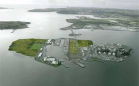
The remediation project, delivered on time and under budget, has seen 22 acres of the island’s East Tip transformed from a desolate, toxic, industrial site into a magnificent public recreational facility for local residents, workers and visitors in what has been one of the biggest environmental works in the history of the state.

The site at Haulbowline Island in Co Cork, formerly the home of Irish Steel, has been used for waste disposal for decades, with an estimated 650,000 cubic metres of slag and other waste metal from the steelworks deposited on the site from the 1960s until steel making ended at the plant in 2001.

Adopting the most innovative and customised engineering solutions throughout to overcome many challenges, the East Tip now boasts new playing pitches, walkways, cycleways, seating areas and the planting of hundreds of trees, woodlands and wildflower areas.

The Engineering Project of the Year category is sponsored by Transport Infrastructure Ireland and is voted for by a panel of judges and the public.

To read much more on the project click here (scroll down) to sub-heading: 'Immensely Challenging' 

Published in Cork Harbour

#corkharbour - Set to open on Haulbowline Island in Cork Harbour, is a public park despite warnings in a 2017 report that chemical contamination at the island’s former steel site has the potential to cause risks to users of a future park.

Now home to the Irish Naval Service, the GreenNews.ie reports that Haulbowline formerly housed the Irish Steel plant in the centre of the island from the late 1930s until its closure in 2001.

Over a 40-year period, 650,000 cubic metres of by-products and waste from the steelworks were deposited on a nine-hectare shallow sand spit on the island known as the East Tip.

Cork County Council was appointed as an agent for the Minister for Agriculture to oversee the regularisation of the site.

The East Tip has now been regenerated and is slated to open as a public park shortly, featuring playing pitches, walkways, cycleways, and over 200 trees and wildflower areas.

Much more on this story can be read here. 

Published in Cork Harbour

#NavyNews -  A tour by the Prince of Wales of an Irish Naval Service patrol ship, to retrace steps of his ancestors in Cork and Kerry and be briefed on world-renowned conservation projects around Killarney are planned during his visit to the Republic next month.

It has emerged writes The Belfast Telegraph that the three-day visit was organised at the specific request of the Prince, who has for years wanted to visit a number of historic Cork and Kerry sites.

He will be accompanied by his wife, Camilla the Duchess of Cornwall for the visit, which is scheduled to begin in Cork on June 14.

The Belfast Telegraph has learned that Charles, who visited the Republic with Camilla in 2016, has specifically requested a tour of the historic Haulbowline Naval Base in Cork harbour.

It was formerly a strategically important dockyard of Britain's Royal Navy.

First fortified in 1602, not long after the Spanish Armada's failed invasion bid, Haulbowline Island is now the main base of the Irish Naval Service.

For more on the visit to the naval base located in lower Cork Habour click here.

Published in Navy

#CorkHarbour - Independent.ie reports that firefighters have extinguished a blaze that broke out last night (Thursday 21 December) at the Naval Service base on Haulbowline Island.

The incident began around 9pm in a disused warehouse next to the officers’ mess and a number of other key buildings.

The fire quickly spread to the roof, where it could be seen across Cork Harbour.

All Naval Service personnel on base at the time were evacuated as a precaution and there were no casualties reported.

Marine Minister Michael Creed was on the other side of Haulbowline earlier this week to inspect remediation works on the East Tip waste site, as previously reported on Afloat.ie.

Published in Cork Harbour

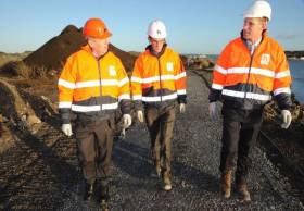
#CorkHarbour - Marine Minister Michael Creed visited the East Tip at Haulbowline yesterday (Wednesday 20 December) to inspect progress on remediation works on the Cork Harbour island.

The minister’s visit follows the signing in July of the contract to commence an extensive remediation of the large East Tip waste deposit site as the main focus of the Haulbowline Island remediation project.

“I am very pleased to see the works now underway on the remediation of the East Tip site on Haulbowline,” said Minister Creed from the site. “Over the next 15 months the island will undergo a period of intense activity as the waste materials which have blighted the East Tip site are addressed.”

Cork County Council is acting as agent of the minister in the remediation project. The contract was awarded by Cork County Council to a consortium led by PJ Hegarty & Sons Ltd.

Cllr Sinead Sheppard said: “East Cork communities are relieved to see remedial works begin in the East tip site of Haulbowline and are grateful to Cork County Council for all the work carried out on the site making it safe and stable for the people living in the area.”

Cork County Council chief executive Tim Lucey added: “We have already reached a number of key milestones in this project including preparatory work which cleared the way for the completion of the project in the East Tip.”

Works being carried out on-site include marine elements to prevent tidal incursions to the site, access and infrastructure works and capping the waste materials to render the site safe, stable and suitable for future uses. Remediation is expected to be completed by the end of 2018.

Published in Cork Harbour
Tagged under

#CorkHarbour - Marine Minister Michael Creed today (Monday 10 July) welcomed the signing of contracts to commence remediation of the East Tip as the main focus of the Haulbowline Island remediation project.

Commenting at the signing, Minister Creed said: “I am delighted that the tender process for this crucial step has been successfully concluded and that we can now look forward to the core remediation work at Haulbowline Island being addressed. 

“The Government is committed to remediating Haulbowline Island and the East Tip is one of the most important aspects to be addressed.”

Cork County Council is acting as agent of the minister in the remediation of Haulbowline Island. The contract is being awarded by Cork County Council to a consortium led by PJ Hegarty & Sons Ltd and is for an extensive remediation of the East Tip waste deposit site.

The works on the Cork Harbour island — which also houses the headquarters of the Naval Service — will include marine elements to prevent tidal incursions to the site, access and infrastructure works and capping the waste materials to render the site safe, stable and suitable for future uses.

“We can expect remediation works will intensify from now until late 2018,” added Minister Creed. “There will be significant construction activity on the island, it will bring substantial benefits to the local economy and transform the island into a genuine national infrastructural asset.”

Published in Cork Harbour
Tagged under

“The boy stood on the burning deck,” is one of the most famous lines in literature and particularly relevant in the maritime sphere. Many people can quote the next line…”Whence all but he had fled…” But why was he there, on what ship and in what circumstances? On this week’s edition of THIS ISLAND NATION we tell you the full story. While listening to it, I compared it with a following story on the programme, the threat to the operations of the Irish Naval Service by a commercial company.

It seems ludicrous that a fully operational Naval Service is under threat, but so it is and the warning has come from the Department of Defence, so it is the opinion of Government.

“This cannot be an acceptable situation….for the necessary functioning of a fully operational Naval Base…..” Those words, from the Department of Defence, are blunt and were made in a major intervention at a public inquiry held by Bord Pleanala into the Indaver Ireland waste company’s third attempt to build a hazardous waste incinerator at Ringaskiddy in Cork Harbour, close to Naval Base headquarters. The Department went further, stating that the location of the incinerator would also affect Air Corps operations, which “may be forced to impose a ‘no-fly’ restriction” around Haulbowline Island. “In addition, Haulbowline Island is accessed by road as a sort of cul de sac to the Ringaskiddy Road. The proposed incinerator is to be built adjacent to this road, before Haulbowline. Therefore, in the event of any accident at the incinerator, road access to and from Haulbowline is threatened. For example, if an accident at the incinerator necessitated local area evacuation, the evacuation of Haulbowline would be denied.

“This cannot be an acceptable situation for those that work at or visit Haulbowline, nor for the necessary functioning of a fully operational Naval Base therein.”

That makes the threat to the Naval Service very clear. No nation can accept a restriction imposed on its Naval Service operations. That must be national policy. I am proud of our Naval Service. It is a professional, top-level maritime organisation. Its rescue work in Irish waters has been superb. Its performance on refugee rescue in the Mediterranean has raised the profile of Ireland as a maritime nation. I do not accept that its operations should be threatened. I live in the Cork Harbour area. Through my kitchen window I see three wind turbines and several chemical factories. So harbour industrial development is an accepted part of my daily life, but a threat to our Naval Service is not acceptable.

Also under threat, publicly stated by the Minister for the Marine, is €500m. of marine development investment in the harbour if the incinerator, which he has described as “wrong place, wrong time,” is built. Concern has been voiced about youth sailing close to the incinerator and, if Air Corps helicopter operations are affected, what about the effect on Coast Guard helicopter operations in the area?

This is the 50th edition of THIS ISLAND NATION so a somewhat unusual coincidence of two Naval stories on the programme - that of the legendary boy who stood on the burning deck of the flagship of Napoleon’s fleet at the Battle of the Nile, the three-decked, 120-gun L’Orient and the threat to Ireland’s Naval Service

• Listen to the programme below:

Published in Island Nation
Page 1 of 2

General Information on using Waterways Ireland inland navigations

Safety on the Water

All users of the navigations are strongly recommended to make themselves aware of safety on the water for whatever activity they are involved in and to read the advice offered by the various governing bodies and by:

The Dept. of Transport, Ireland: www.gov.ie/transport and The Maritime and Coastguard Agency, UK, The RNLI – Water Safety Ireland for information in terms of drowning prevention and water safety.

Registration of Vessels

All vessels using the Shannon Navigation, which includes the Shannon-Erne Waterways and the Erne System must be registered with Waterways Ireland. Only open undecked boats with an engine of 15 horsepower or less on the Shannon Navigation, and vessels of 10 horsepower or less on the Erne System, are exempt. Registration is free of charge.

Craft registration should be completed online at: https://www.waterwaysireland.org/online-services/craft-registration

Permits for use of the Grand and Royal Canals and the Barrow Navigation

All vessels using the Grand and Royal Canals and the Barrow Navigation must display appropriate valid Permit(s) i.e A Combined Mooring and Passage Permit (€126) and if not intending to move every five days, an Extended Mooring Permit (€152).

Permit applications should be completed online at: https://www.waterwaysireland.org/online-services/canal-permits

Passage on the Royal and Grand Canals – Dublin Area

For boat passage through the locks east of Lock 12 into / out of Dublin on either the Royal or Grand Canals, Masters are requested to contact the Waterways Ireland Eastern Regional Office (M-F 9.30am-4.30pm) on tel: +353(0)1 868 0148 or email [email protected] prior to making passage in order to plan the necessary lock-keeping assistance arrangements.

On the Grand Canal a minimum of two days notice prior to the planned passage should be given, masters should note that with the exception of pre-arranged events, a maximum of 2 boats per day will be taken through the locks, travelling either east or west.

Movements in or out of the city will be organised by prior arrangement to take place as a single movement in one day. Boaters will be facilitated to travel the system if their passage is considered to be safe by Waterways Ireland and they have the valid permit(s) for mooring and passage.

Newcomen Lifting Bridge

On the Royal Canal two weeks’ notice of bridge passage (Newcomen Lifting Bridge) is required for the pre-set lift date, and lock assistance will then also be arranged. A minimum of 2 boats is required for a bridge lift to go ahead.

Waterways Ireland Eastern Regional Office (Tel: +353(0)1 868 0148 or [email protected] ) is the point of contact for the bridge lift.

A maximum number of boats passing will be implemented to keep to the times given above for the planned lifts (16 for the Sat / Sun lifts & 8 for the weekday lifts). Priority will be given on a first come first served basis.

On day of lift, boaters and passengers must follow guidance from Waterways Ireland staff about sequence of passage under bridge & through Lock 1, and must remain within signed and designated areas.

Events Held on the Waterways

All organised events taking place on the waterways must have the prior approval of Waterways Ireland. This is a twelve week process and application forms must be accompanied with the appropriate insurance, signed indemnity and risk assessment. The application should be completed on the Waterways Ireland events page at :

https://www.waterwaysireland.org/online-services/event-approval

Time Limits on Mooring in Public Harbours

On the Shannon Navigation and the Shannon-Erne Waterway craft may berth in public harbours for five consecutive days or a total of seven days in any one month.

On the Erne System, revised Bye Laws state that: No master or owner shall permit a vessel, boat or any floating or sunken object to remain moored at or in the vicinity of any public mooring, including mooring at any other public mooring within 3 kilometres of that location, for more than 3 consecutive days and shall not moor at that same mooring or any other public mooring within 3 kilometres of that location within the following 3 consecutive days without prior permission by an authorised official.

Winter Mooring on the Shannon Navigation and Shannon Erne Waterway

Winter mooring may be availed of by owners during the period 1 Nov to 31 Mar by prior arrangement and payment of a charge of €63.50 per craft. Craft not availing of Winter Mooring must continue to comply with the “5 Day Rule”. Winter Mooring applications should be completed online at : https://www.waterwaysireland.org/online-services/winter-moorings-booking

Owners should be aware that electricity supply and water supply to public moorings is disconnected for the winter months. This is to protect against frost damage, to reduce running costs and to minimise maintenance requirements during the winter months.

Vessel owners are advised that advance purchasing of electricity on the power bollards leading up to the disconnection date should be minimal. Electricity credit existing on the bollards will not be recoverable after the winter decommissioning date. Both services will be reinstated prior to the commencement of the next boating season.

Smart Cards

Waterways Ireland smart cards are used to operate locks on the Shannon Erne Waterway, to access the service blocks, to use the pump-outs along the navigations, to avail of electrical power at Waterways Ireland jetties.

Berthing in Public Harbours

Masters are reminded of the following:

  • Equip their vessel with mooring lines of appropriate length and strength and only secure their craft to mooring bollards and cleats provided for this purpose.
  • Ensure the available berth is suitable to the length of your vessel, do not overhang the mooring especially on finger moorings on floating pontoon moorings.
  • Ensure mooring lines, electric cables and fresh water hoses do not create a trip hazard on public jetties for others users.
  • Carry sufficient fenders to prevent damage to your own vessel, other vessels and WI property.
  • Allow sufficient space between your vessel and the vessel ahead /astern (c.1m) for fire safety purposes and /or to recover somebody from the water.
  • Do not berth more than two vessels side by side and ensure there is safe access/egress at all times between vessels and onto the harbour itself.
  • Do not berth in such a way to prevent use of harbour safety ladders, slipways or pump-outs.
  • Do not allow the bow of your vessel to overhang the walkway of a floating mooring thus creating a hazard for others with an overhanging anchor or bow fendering.
  • Animals are not allowed to be loose or stray at any time.
  • Harbour and jetty infrastructure such as railings, power pedestals, fresh water taps, electric light poles, safety bollards, ladders etc are not designed for the purpose of mooring craft , they will not bear the strain of a vessel and will be damaged.
  • At Carrybridge on the Erne System, Masters of vessels are not permitted to use stern on mooring. Masters of vessels must use the mooring fingers for mooring of vessels and for embarkation / disembarkation from vessels.

Passenger Vessel Berths

Masters of vessels should not berth on passenger vessel berths where it is indicated that an arrival is imminent. Passenger vessels plying the navigations generally only occupy the berths to embark and disembark passengers and rarely remain on the berths for extended periods or overnight.

Lock Lead-in Jetties

Lead-in jetties adjacent to the upstream and downstream gates at lock chambers are solely for the purpose of craft waiting to use the lock and should not be used for long term berthing.

Vessel Wake

Vessel wake, that is, the wave generated by the passage of the boat through the water, can sometimes be large, powerful and destructive depending on the hull shape and engine power of the vessel. This wake can be detrimental to other users of the navigation when it strikes their craft or inundates the shoreline or riverbank. Masters are requested to frequently look behind and check the effect of their wake / wash particularly when passing moored vessels, on entering harbours and approaching jetties and to be aware of people pursuing other activities such as fishing on the riverbank.

Speed Restriction

A vessel or boat shall not be navigated on the Shannon Navigation at a speed in excess of 5 kph when within 200 metres of a bridge, quay, jetty or wharf, when in a harbour or canal or when passing within 100 metres of a moored vessel or boat.

Vessels navigating the Shannon-Erne Waterway should observe the general 5 kph speed limit which applies along the waterway. This is necessary in order to prevent damage to the banks caused by excessive wash from vessels.

Vessels navigating the Erne System should observe the statutory 5kt / 6mph / 10kph speed limit areas.

A craft on the Royal and Grand canals shall not be navigated at a speed in excess of 6km per hour.

A craft on the Barrow Navigation shall not be navigated at a speed in excess of 11km per hour except as necessary for safe navigation in conditions of fast flow.

Bank Erosion

Narrow sections of all the navigations are particularly prone to bank erosion due to the large wash generated by some craft. Masters are requested to be vigilant and to slow down to a speed sufficient to maintain steerage when they observe the wash of their craft inundating the river banks.

Unusual Waterborne Activity

Unusual waterborne vessels may be encountered from time to time, such as, hovercraft or amphibious aircraft / seaplanes. Masters of such craft are reminded to apply the normal “Rule of the Road” when they meet conventional craft on the water and to allow extra room to manoeuvre in the interest of safety.

Sailing Activity

Mariners will encounter large numbers of sailing dinghies from late June to August in the vicinity of Lough Derg, Lough Ree and Lower Lough Erne. Sailing courses are marked by yellow buoys to suit weather conditions on the day. Vessels should proceed at slow speed and with due caution and observe the rules of navigation when passing these fleets, as many of the participants are junior sailors under training.

Rowing

Mariners should expect to meet canoes and vessels under oars on any part of the navigations, but more so in the vicinity of Athlone, Carrick-on-Shannon, Coleraine, Enniskillen and Limerick. Masters are reminded to proceed at slow speed and especially to reduce their wash to a minimum when passing these craft as they can be easily upset and swamped due to their very low freeboard and always be prepared to give way in any given traffic situation.

Canoeing

Canoeing is an adventure sport and participants are strongly recommended to seek the advice of the sport’s governing bodies i.e Canoeing Ireland and the Canoe Association of Northern Ireland, before venturing onto the navigations.

Persons in charge of canoes are reminded of the inherent danger to these craft associated with operating close to weirs, sluice gates, locks and other infrastructure particularly when rivers are in flood and large volumes of water are moving through the navigations due to general flood conditions or very heavy localised precipitation e.g. turbulent and broken water, stopper waves. Shooting weirs is prohibited without prior permission of Waterways Ireland.

Canoeists should check with lockkeepers prior entering a lock to ensure passage is done in a safe manner. Portage is required at all unmanned locks.

Canoe Trail Network – "Blueways"

Masters of powered craft are reminded that a canoe trail network is being developed across all navigations and to expect more organised canoeing along these trails necessitating slow speed and minimum wash when encountering canoeists, rowing boats etc

Rockingham and Drummans Island Canals – Lough Key

It is expected that work on Rockingham and Drummans Island Canals on Lough Key will be completed in 2021. Access to these canals will be for non-powered craft only, eg canoes, kayaks, rowing boats.

Fast Powerboats and Personal Watercraft (Jet Skis)

Masters of Fast Powerboats (speed greater than 17kts) and Personal Watercraft (i.e.Jet Skis) are reminded of the inherent dangers associated with high speed on the water and especially in the confines of small bays and narrow sections of the navigations. Keeping a proper look-out, making early alterations to course and /or reducing speed will avoid conflict with slower vessels using the navigation. Personal Watercraft are not permitted to be used on the canals.

Towing Waterskiers, Wakeboarders, Doughnuts etc

Masters of vessels engaged in any of these activities are reminded of the manoeuvring constraints imposed upon their vessel by the tow and of the added responsibilities that they have to the person(s) being towed. These activities should be conducted in areas which are clear of conflicting traffic. It is highly recommended that a person additional to the master be carried to act as a “look-out” to keep the tow under observation at all times.

Prohibition on Swimming

Swimming in the navigable channel, particularly at bridges, is dangerous and is prohibited due to the risk of being run over by a vessel underway in the navigation.

Age Restrictions on operating of powered craft

In the Republic of Ireland, Statutory Instrument 921 of 2005 provides the legal requirements regarding the minimum age for operating of powered craft. The Statutory Instrument contains the following requirements:

- The master or owner of a personal watercraft or a fast power craft shall take all reasonable steps to ensure that a person who has not attained the age of 16 years does not operate or control the craft

- The master or owner of a pleasure craft powered by an engine with a rating of more than 5 horse power or 3.7 kilowatts shall take all reasonable steps to ensure that a person who has not attained the age of 12 years does not operate or control the craft.

Lifejackets and Personal Flotation Devices (PFDs)

Lifejackets and PFD’s are the single most important items of personal protective equipment to be used on a vessel and should be worn especially when the vessel is being manoeuvred such as entering / departing a lock, anchoring, coming alongside or departing a jetty or quayside.

In the Republic of Ireland, Statutory Instrument 921 of 2005 provides the legal requirements regarding the wearing of Personal Flotation Devices. The Statutory Instrument contains the following requirements:

- The master or owner of a pleasure craft (other than a personal watercraft) shall ensure, that there are, at all times on board the craft, sufficient suitable personal flotation devices for each person on board.

- A person on a pleasure craft (other than a personal watercraft) of less than 7 metres length overall shall wear a suitable personal flotation device while on board an open craft or while on the deck of decked craft, other than when the craft is made fast to the shore or at anchor.

- The master or owner of a pleasure craft (other than a personal watercraft) shall take all reasonable steps to ensure that a person who has not attained the age of 16 years complies with paragraph above.

- The master or owner of a pleasure craft (other than a personal watercraft), shall take all reasonable steps to ensure that a person who has not attained the age of 16 years wears a suitable personal flotation device while on board an open craft or while on the deck of a decked craft other than when it is made fast to the shore or at anchor.

- The master or owner of a pleasure craft (other than a personal watercraft) shall take all reasonable steps to ensure that a person wears a suitable personal flotation device, at all times while – (a) being towed by the craft, (b) on board a vessel or object of any kind which is being towed by the craft.

Further information is available at: http://www.irishstatutebook.ie/eli/2005/si/921/made/en/print

Firing Range Danger Area – Lough Ree

The attention of mariners is drawn to the Irish Defence Forces Firing Range situated in the vicinity of buoys No’s 2 and 3, on Lough Ree on the Shannon Navigation. This range is used regularly for live firing exercises, throughout the year, all boats and vessels should stay clear of the area marked with yellow buoys showing a yellow "X" topmark and displaying the word "Danger".

Shannon Navigation, Portumna Swing Bridge Tolls

No attempt should be made by Masters’ of vessels to pay the bridge toll while making way through the bridge opening. Payment will only be taken by the Collector from Masters when they are secured alongside the jetties north and south of the bridge.

Navigating from Killaloe to Limerick on the Shannon Navigation

The navigation from Killaloe to Limerick involves passage through Ardnacrusha locks, the associated headrace and tailrace and the Abbey River into Limerick City. Careful passage planning is required to undertake this voyage. Considerations include: lock passage at Ardnacrusha, water flow in the navigation, airdraft under bridges on Abbey River in Limerick, state of tide in Limerick

Users are advised to contact the ESB Ardnacrusha hydroelectric power station (00353 (0)87 9970131) 48 hours in advance of commencing their journey to book passage through the locks at Ardnacrusha. It is NOT advised to undertake a voyage if more than one turbine is operating (20MW), due to the increased velocity of flow in the navigation channel, which can be dangerous. To ascertain automatically in real time how many turbines are running, users can phone +353 (0)87 6477229.

For safety reasons the ESB has advised that only powered craft with a capacity in excess of 5 knots are allowed to enter Ardnacrusha Headrace and Tailrace Canals.

Passage through Sarsfield Lock should be booked on +353-87-7972998, on the day prior to travel and it should be noted also that transit is not possible two hours either side of low water.

A Hydrographic survey in 2020 of the navigation channel revealed that the approach from Shannon Bridge to Sarsfield Lock and the Dock area has silted up. Masters of vessels and water users are advised to navigate to the Lock from Shannon bridge on a rising tide one or two hours before High Tide.

Lower Bann Navigation

The attention of all users is drawn to the “Users Code for the Lower Bann”, in particular to that section covering “Flow in the River” outlining the dangers for users both on the banks and in the navigation, associated with high flow rates when the river is in spate. Canoeists should consult and carry a copy of the “Lower Bann Canoe Trail” guide issued by the Canoe Association of Northern Ireland. Users should also contact the DfI Rivers Coleraine, who is responsible for regulating the flow rates on the river, for advisory information on the flow rates to be expected on any given day.

DfI Rivers Coleraine. Tel: 0044 28 7034 2357 Email: [email protected]

Lower Bann Navigation – Newferry – No wake zone

A No Wake Zone exists on the Lower Bann Navigation at Newferry. Masters of vessels are requested to proceed at a slow speed and create no wake while passing the jetties and slipways at Newferry.

Overhead Power Lines (OHPL) and Air draft

All Masters must be aware of the dangers associated with overhead power lines, in particular sailing vessels and workboats with cranes or large air drafts. Voyage planning is a necessity in order to identify the location of overhead lines crossing the navigation.

Overhead power line heights on the River Shannon are maintained at 12.6metres (40 feet) from Normal Summer level for that section of navigation, masters of vessels with a large air draft should proceed with caution and make additional allowances when water levels are high.

If a vessel or its equipment comes into contact with an OHPL the operator should NOT attempt to move the vessel or equipment. The conductor may still be alive or re-energise automatically. Maintain a safe distance and prevent third parties from approaching due to risk of arcing. Contact the emergency services for assistance.

Anglers are also reminded that a minimum ground distance of 30 metres should be maintained from overhead power lines when using a rod and line.

Submarine Cables and Pipes

Masters of vessels are reminded not to anchor their vessels in the vicinity of submarine cables or pipes in case they foul their anchor or damage the cables or pipes. Look to the river banks for signage indicating their presence.

Water Levels - Precautions

Low Water Levels:

When water levels fall below normal summer levels masters should be aware of:

Navigation

To reduce the risk of grounding masters should navigate on or near the centreline of the channel, avoid short cutting in dog-legged channels and navigating too close to navigation markers.

Proceeding at a slow speed will also reduce “squat” effect i.e. where the vessel tends to sit lower in the water as a consequence of higher speed.

Slipways

Reduced slipway length available under the water surface and the possibility of launching trailers dropping off the end of the concrete apron.

More slipway surface susceptible to weed growth requiring care while engaged in launching boats, from slipping and sliding on the slope. Note also that launching vehicles may not be able to get sufficient traction on the slipway once the craft is launched to get up the incline.

Bank Erosion

Very dry riverbanks are more susceptible to erosion from vessel wash.

Lock Share

Maximising on the number of vessels in a lock will ensure that the total volume of water moving downstream is decreased. Lock cycles should be used for vessels travelling each way.

High Water Levels:

When water levels rise above normal summer level masters should be aware of:

Navigation

Navigation marks will have reduced height above the water level or may disappear underwater altogether making the navigable channel difficult to discern.

In narrow sections of the navigations water levels will tend to rise more quickly than in main streams and air draft at bridges will likewise be reduced.

There will also be increased flow rates particularly in the vicinity of navigation infrastructure such as bridges, weirs, locks etc where extra care in manoeuvring vessels will be required.

Harbours and Jetties

Due care is required in harbours and at slipways when levels are at or near the same level as the harbour walkways' as the edge will be difficult to discern especially in reduced light conditions. It is advised that Personal Flotation Devices be worn if tending to craft in a harbour in these conditions.

Slipways

Slipways should only be used for the purpose of launching and recovering of water craft or other objects from the water. Before using a slipway it should be examined to ensure that the surface has sufficient traction/grip for the intended purpose such as launching a craft from a trailer using a vehicle, that there is sufficient depth of water on the slipway to float the craft off the trailer before the concrete apron ends and that the wheels of the trailer do not drop off the edge of the slipway. That life-saving appliances are available in the vicinity, that the vehicle is roadworthy and capable of coping with the weight of the trailer and boat on the incline. It is recommended that slipway operations are conducted by two persons.

Caution to be Used in Reliance upon Aids to Navigation

The aids to navigation depicted on the navigation guides comprise a system of fixed and floating aids to navigation. Prudent mariners will not rely solely on any single aid to navigation, particularly a floating aid to navigation. With respect to buoys, the buoy symbol is used to indicate the approximate position of the buoy body and the ground tackle which secures it to the lake or river bed. The approximate position is used because of the practical limitations in positioning and maintaining buoys in precise geographical locations. These limitations include, but are not limited to, prevailing atmospheric and lake/river conditions, the slope of and the material making up the lake/river bed, the fact that the buoys are moored to varying lengths of chain, and the fact that the buoy body and/or ground tackle positions are not under continuous surveillance. Due to the forces of nature, the position of the buoy body can be expected to shift inside and outside the charted symbol.

Buoys and perches are also moved out of position or pulled over by those mariners who use them to moor up to instead of anchoring. To this end, mariners should always monitor their passage by relating buoy/perch positions with the published navigation guide. Furthermore, a vessel attempting to pass close by always risks collision with a yawing buoy or with the obstruction that the buoy or beacon/perch marks.

Masters of Vessels are requested to use the most up to date Navigation guides when navigating on the Inland Waterways.

Information taken from Special Marine Notice No 1 of 2023