


Displaying items by tag: Haulbowline
Questions for Minister over Haulbowline Dump

Minister for the Environment Phil Hogan is set to be quizzed over plans to deal with the toxic waste site on Haulbowline island in Cork Harbour, the Irish Examiner reports.
As previously reported on Afloat.ie, two weeks ago the European Commission gave the Government three months to take action over the the former steel works, which contains an estimated 500,000 tonnes of toxic metal waste and cancer-causing materials.
The minister will meet Cork County Council on 9 May after an official request to discuss the matter was made by Cobh independent councillor Seán O'Connor.
Labour councillor John Mulvihill said locals would not be happy until the waste was removed and a study conducted to examine if there was any link between the site and high cancer rates in the area.
The Irish Examiner has more on the story HERE. See also our story Hot site in the harbour.
Hot site in Cork Harbour
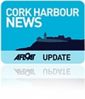
Haulbowline island is making headlines because of cancer-causing residue, left over from the Irish Steel plant that once occupied the land. It has been confirmed that a cache of 500,000 tonnes of slag and toxic waste material were buried at the former steelworks. Now the Government has three months to start cleaning the toxic waste site in Haulbowline or risk court action by the European Commission.
The report, compiled in 2005 but, like the toxins, only seeping out later, shows high levels of several heavy metals at the plant, both in soil samples and water samples.
The site at Haulbowline. Photo: Bob Bateman
Chromium six, which causes cancer both by inhalation and by infecting groundwater, was revealed to be present in massive quantities at Haulbowline. The mineral is a highly toxic anti-corrosion agent used in the steel-making process, but which is gradually being phased out due to its toxicity.
The site is a blight on one of the finest natural harbours in the world, and home to one of the best regattas in the world. How can sailors make their views known on this subject? We'd like to hear your thoughts – [email protected]
'Three Months to Clean Up Haulbowline' Says Europe

The Government has three months to start cleaning the toxic waste site in Haulbowline or risk court action by the European Commission, the Irish Examiner reports.
The site at the former Irish Steel plant contains an estimated 500,000 tonnes of waste, including toxic heavy metals and cancer causing materials, and has been blamed for the area's notoriety in having one of the highest cancer rates in Ireland.
Two petitions from local groups totalling 5,500 signatures were presented to the European Parliament's petitions committee in Brussels on Wednesday, according to The Irish Times.
Mary O'Leary, chair of the Cork Harbour Alliance for a Safe Environment (Chase), outlined to the committe that in spite of four reports between 1998 and 2005 highlighting the dangers of contamination from the site, the Irish State has failed to regulate it or take clean-up action.
Petitions committee member Jean-Francoise Brakland said he "fully agreed" with locals' concerns over the "dangerous mess".
He also commended Environment Minister Phil Hogan for understanding "the difficulties and the challenges of environmental implementation" but cautioned that "we are not going to wait for the next 10 years".
Brakland promised that if no real action was taken on Haulbowline after three months, the commitee would seek a court judgement againt the State.
The Irish Examiner has more on the story HERE.
Navy Escort Detained Trawler to Castletownbere

Less then a month ago the Naval Service detained a Northern Irish registered fishing vessel the Lynn Marie seven miles east off Bray Head. Onboard was a crew of 4 UK nationals who were taken into custody to the Gardai after the trawler was escorted by the CPV L.E. Orla to Dun Laoghaire Harbour. To read more about this detention click here.
Ironically the L.E. Orla was a former Royal Naval vessel, HMS Swift (P241) which was deployed on her first assignment to the Hong Kong Patrol Squadron for a four-year period. In 1988 Margaret Thatcher's Conservative Party Government disposed HMS Swift and HMS Swallow (P242) to the Irish Naval Service. The pair were built by Hall Russell Shipyard of Aberdeen as part of an eight 'Peacock' class coastal patrol vessel (CPV).
The 'Peacock' pair were commissioned into the Naval Service and renamed L.E. Orla (P41) and L.E. Ciara (P42) in a ceremony attended by An Taoiseach Charles J. Haughey at the Naval Base in Haulbowline, Cork Harbour.
This weeks' detention is the second conducted by the Naval Service in 2011. Last year the Naval Service carried out 1,666 vessel boardings which resulted in 70 warnings and eight detentions.
- Irish Naval Service
- Cork Harbour
- Northern Ireland
- Haulbowline
- castletownbere
- naval service
- LE Niamh
- Royal Navy
- Ports and Shipping News
- Lynn Marie
- Fishery Breaches
- Fishery Detention
- Fishing Trawler
- Peacock Class
- Hong Kong
- Hall Russell
- Appledore Shipbuilders
- LE Orla
- HMS Swift
- LE Ciara
- HMS Swallow
- Margaret Thatcher
- Conservative Party
- An Taoiseach
- Charles J. Haughey
- Naval Base
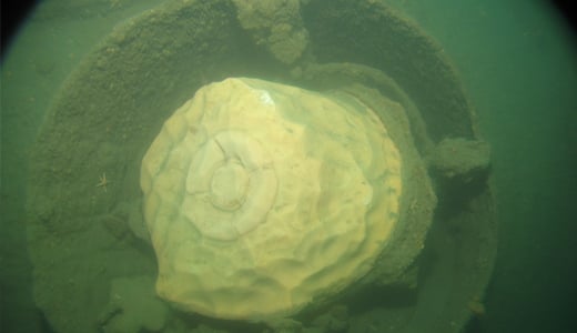
German U-Boat Rediscovered in Cork Harbour
Scuba Divers have found a fully intact World War I U-Boat on the seabed just outside Cork harbour, some 93 years after it sank writes Timmy Carey.
During the First World War the menace provided by German U-Boats would prove deadly to the Allies and were responsible for sinking millions of tons of shipping; indeed German U-Boats almost changed the course of the war. Most allied ships sunk by U-boats were sunk by either torpedo, deck gunfire or explosives placed aboard the ship by U-boat crew. A smaller number of ships were also sunk by mine laying U-boats; one of these being UC42. On the 10th of September of 1917 UC42 was laying her deadly cargo of mines at the entrance to Cork harbour when a terrific explosion occurred which resulted in a grim death for all 27 German Submariners aboard.
As the submarine sank to the seabed the German submariners were trapped inside UC42, which would soon become their metal tomb.
On November 2nd of that year, hardhat divers from the Haulbowline dockyard dived the area and positively identified the U-boat as UC42, noting the stern damage to the submarine and the presence of the bodies of some of the German submariners. During 1918 the submarine was dived by Haulbowline and American divers in an effort to disarm all the mines and torpedoes still aboard, with USS Melville taking three of the mines. It was widely believed that in July 1919 divers using explosives from HMS Vernon torpedo school had destroyed the submarine with the remains being dispersed on the seabed by wire sweeps.
With the advent of scuba diving many divers have since searched for the scattered remains of UC42 around Cork harbour with no luck until a recent dive by two local divers Ian Kelleher and Niall O Regan descended a shot line to see the menacing sight of the hull of a German U-boat emerge from the shadows. Both divers were very surprised and ecstatic to find a fully intact World War I U-Boat in 27 meters of water just outside Cork harbour in good condition with little obvious explosive damage from the British naval dive team.
A local dive team of five divers had spent the previous 12 months carrying out a careful methodical search of the greater harbour area determined to find the remains of the submarine; their hard labours finally paying dividends when Niall and Ian identified the presence of the submarine. The dive team consisted of Ian Kelleher, Niall O Regan, Philip Johnston, Eoin Mc Garry and Timmy Carey.
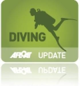
Over the past few weeks the divers have carefully and methodically videoed and photographed the Submarine and taken various measurements to record the wrecks' condition. Over a number of dives the dive team carefully cleaned the growth from the propeller and after some methodical cleaning found the U-Boats number UC42 stamped into it; positively identifying the submarine.
As the submarine is a war grave and contains the remains of so many young German submariners the dive team also laid a plaque of remembrance, which was erected near the submarines propellers; to act as a memorial to the German submariners forever entombed in UC42. The plaque was kindly donated to the dive team by John O' Mahony of Complete Signs.
The image of the U-Boats propellor with the markings identifying the U-Boat. Photo: Timmy Carey
A badly decayed mine on UC42 still in the mine chute. Photo: Timmy Carey
Department Denies Haulbowline Report

The spokesman told RTE news there is no likelihood of fines being imposed.
He added that the notice, which was issued last week, is part of a long standing legal case being taken against Ireland relating to other waste legacy sites.
Haulbowline was mentioned because it had no waste license.
Minister For Defence Attends Naval Service Commissioning Ceremony In Cork
Minister for Defence, Mr. Tony Killeen, TD today attended the Naval Service Commissioning Ceremony of the 48th Naval Service Cadet Class at Haulbowline in Cork.
The Minister was welcomed to the Naval Base by the Deputy Chief of Staff (Operations), Major General Ralph James and the Flag Officer Commanding the Naval Service, Commodore Frank Lynch.
Speaking at the Commissioning Ceremony for 5 members of the 48th Naval Cadet Class, Minister Killeen said: "Today's ceremony is the culmination of two years of hard work and dedication by these five young people. Over the last two years they have undergone a rigorous training programme, covering both professional and academic subjects, and of course hands on experience on the high seas. The training they have received has equipped these young professionals with the skills necessary to face the many and varied challenges they will encounter in the course of their military careers. They have successfully achieved the high standards required of them in a wide variety of activities and I have no doubt that they will be at the helm of the development of the Naval Service long into the future."
Minister Killeen added: "As you will all be aware, my colleague the Minister for Finance and I were very pleased to be able to announce during our recent visit to the Naval Base that Government approval had been granted for the purchase of two new Offshore Patrol Vessels for the Naval Service.
"The Government's decision is of course subject to the negotiations with the preferred bidder, Babcock Marine, reaching a satisfactory conclusion. Today, I am delighted to report that very good progress has been made since the announcement and I am confident that I will be in a position to formally place a contract within a number of weeks.
"It is indeed very heartening that such positive news for the Naval Service coincides with the commissioning today of this new class of cadets. These young officers can look forward to careers which will be served on these modern new vessels.
"The Naval Service makes an important contribution across a wide variety of roles assigned by Government. The success of the Naval Service in the areas of fishery protection, search and rescue and the provision of aid to the civil power is clear for all to see. These high profile roles have the added benefit of conveying the importance of the Naval Service to the wider community. In this context, as Minister for Defence, I am committed to continuing the development of the Naval Service to ensure that it is capable of fulfilling the full range of tasks assigned to it by the Government. To this end there is a Cadetship competition currently being held in order to recruit a total of thirty Cadets, six of whom will join the Naval Service. It is anticipated that their training will commence in December of this year.
"I would like to pay tribute to the Naval College staff involved in preparing these cadets for officer duty. Today however, belongs primarily to these new officers. They are charged with providing leadership and guidance to others, a responsibility, I have no doubt they will discharge with excellence", the Minister concluded.

The Minister for Defence, Mr. Tony Killeen, TD, with his cabinet colleague the Minister for Finance, Mr. Brian Lenihan, TD, were today, at the Naval Service Base in Haulbowline, Cork to welcome home the Naval Service vessel the L.E. Niamh from her ten week mission to Latin America.
This deployment was in support of the strong cultural and heritage links between Ireland and South America, to mark the celebration of the bicentenaries of independence by Mexico, Argentina, and Chile, and to promote Ireland and Irish trade links in these countries.
The Captain of the LE Niamh is Lieutenant Commander Kenneth Minehane, a native of Bantry, Co. Cork, and there were 46 crew on the mission.
LE Niamh arrives back into Haulbowline today. Photo: Bob Bateman
Speaking on the LE Niamh in Cork Minister Killeen said "The trade and diplomatic mission to Latin America, which was undertaken by the LE Niamh, was a significant initiative from Ireland's perspective and is an example of the continued effective inter-departmental cooperation, particularly in the area of trade. The Captain and crew of the ship have carried out excellent work on behalf of the State in furthering our national interests in the region. I would like to commend them on their achievements and thank them for their service."
Minister Killeen continued "I am delighted to be able to announce today that following discussions with my cabinet colleague Mr. Brian Lenihan, T.D., Government approval has been received for the Department of Defence and the Naval Service to enter into discussions with UK based shipbuilder Babcock Marine, with a view to finalising negotiations for the purchase of two new Naval Service Offshore Patrol Vessels (OPVs).
The decision to proceed with the final award of the contract to purchase the OPV's is subject to these negotiations reaching a satisfactory outcome. I hope to be in a position to make a formal announcement regarding the award of the contract for the new OPV's by November 2010. However, as you can appreciate, as negotiations are ongoing it would be inappropriate for me to comment further on them at this time except to wish the officials in the Department of Defence and the Naval Service well in these negotiations".
Minister Lenihan said "I am also pleased to be here in Haulbowline this afternoon with Minister Killeen for this major announcement. I am especially pleased that in agreeing the Defence Estimates for 2011 it has been possible to provide for this key defence priority."
The older naval ships have a nominal lifespan of 30 years. By 2015, all but two of the current flotilla of eight Naval vessels will be at least 30 years old (which is the normal maximum lifespan of such vessels). The continued use of older vessels is expensive in terms of both maintenance and, more importantly, loss of days on patrol. Notwithstanding increased inspections, maintenance and repair, it is not recommended that any vessel should remain in service beyond 35 years.
The three oldest vessels, LE Emer commissioned in 1978, LE Aoife commissioned in 1979 and LE Aisling commissioned in 1980, remain in service through a programme of continuous planned and preventative maintenance and inspections. These inspections have recently resulted in extensive repairs being carried out to all three vessels with holes in the hull plating of each being detected and repaired in the course of dry docking. All three vessels were out of service for approximately 6 weeks.
Minister Killeen added "The acquisition of two new modern vessels will ensure that the Naval Service continues to be fully equipped to carry out its day to day roles in enforcing the State's sovereign rights over our waters and our fisheries and meeting Ireland's obligations in the area of maritime safety and security and fisheries protection. I am acutely aware of the difficulties for Irish fishermen arising from the damage inflicted by over fishing of some key stocks off our coast. The Naval Service plays a significant role in helping to return these stocks to sustainability."
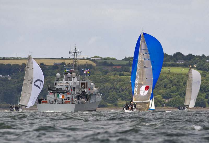
Cork Week and How You Can Win
 How you can win at Cork Week
with more than a little help from local expert Eddie English [pictured left] – Cork Week 2004 (reprinted from Afloat July 2004). For all the up to date information and news on Cork Week click here.
Eddie English stands high on Cobh’s historic waterfront and looks out across Cork Harbour, south towards Roche’s Point Lighthouse and the entrance to the natural sanctuary. Immediately below, a huge Brittany Ferries ship heads slowly out to sea; it’s not even close in size to a previous visitor to the former Queenstown, but then again, the RMS Titanic belonged to a different era.
To his left, the inshore waters north of the Whitegate oil refinery hide the channel to East Ferry where the Marlogue Inn stands over its marina and just opposite, the legendary Murphs on the mainland shore.
On his right, the channel between Spike and Haulbowline Islands and Cobh is the main shipping route for the Port of Cork for ferries, commercial shipping and the Irish Naval Service base.
But it’s the view straight out to sea that confirms one of the magic ingredients that have made Cork Week an international regatta of worldwide repute: vast tracts of open, unobstructed water and all within easy reach of the shoreside facilities of the hosts at the Royal Cork Marina at Crosshaven.
When it comes to local knowledge, few are as expert as English. Not only is he chairman of the event's racing committee, not only does he run a long-established sailing school in the harbour, but when you are offered an insight from someone who takes his dog for a walk on notorious mud banks at low water springs, they tend to be nuggets of the golden variety.

Left: Sigma 33s negotiate Roche’s Point
"The harbour course is the key to Cork Week," says English. "It's the decider where the event is won or lost and has the most variables involved." So this, then, is the Eddie English step-by-step guide to gaining an edge for that course, plus the coastal, wind/leeward and Olympic-type courses at Cork Week 2004.
Harbour Race
Above all, be conservative at the start of the Harbour Race if the tide is with you on the start off Weaver's Point. There can be two knots of tide here typically and an OCS in any fleet represents the end of the story with recovery improbable. Ideally, a short tour of the harbour during the weekend registration stage of Cork Week will pay dividends. If you can, borrow a RIB and take the tour at low-water.
Two marks form part of this course outside the harbour and rounding order will depend on wind-direction on the day. The first is off Ringabella to the south-west shore heading towards Kinsale. If there’s a flood tide, hug the shore. In fact, if the breeze is SW, go right, even in an ebb.
The second is off Trabolgan, east of Roche's Point. Crucially, beware of the strength of tide when traversing the channel across the harbour entrance. Don't just rely on the GPS – plot the tidal vectors to find the true course to steer. Once to the east of Roche's Point, there’s negligible tide and often a tide line can be observed.
This course then takes the fleet into the harbour but beware when entering on the east side of the Harbour mouth – the Cow and Calf rocks are extensions of Roche's Point up to one cable off the shore.

Above: Hugging the shoreline for a tactical advantage
Most races will come into a buoy east of Cobh, making this a long leg in, but offer plenty of hazards on a falling tide. After the Cow and Calf, it’s possible to dodge into White Bay but be wary of rocks and shallows on the south end of the bay close to Roche's Point.
The Dog's Nose promontory is next and it’s possible to cut into the area north of here though close inshore it shallows and the Black Rock is marked by a perch as the main hazard.
Bear in mind the sailing instructions that require clearance of 50 metres off the oil refinery jetty at all times. A listening watch on VHF Ch. 12 is useful for avoiding shipping.

Above: The fleet at anchor – everyone’s gone to the pub...
Once past the refinery jetty, the tide running north-east/south-west for the East Ferry channel can suck you in or push you out.
The alternative to the eastern shore approach is to hug the western shore and involves rock-hopping from Ringabella in past Weaver's Point. An option is to duck into the Owenbue River at Crosshaven – the tide ebbs here up to 30–40 minutes before HW Cobh.
North of here, the Curlane Bank, south of Spike Island, offers an option but beware of shallows. The area south-east of Spike is littered with rocks and, in particular, off the eastern end is a large rock marked by a perch.
The Spit Bank is the biggest in the harbour and is located from the north end of Spike from the lighthouse to the corner off Haulbowline. On very low spring tides, football is played on this bank. The key here is: go as close as you dare. The bank is mostly mud except for ‘The Seven Stones’ aka The Ballast Rocks located approximately two cables east south-east of the No. 20 (Port) Buoy.
Having made the turn for the final approach to the Cobh rounding buoy, one of the showcase marks in the entire event set beneath the picturesque back-drop of the town, this leg from ‘Cuskinny Turn’ offers several options in tide. With the tide is a straight-forward matter of choosing the deepest water so check the charts. Usually, the north shore offers no significant gains. Keep a sharp watch for the passenger ferries running from Cobh to Spike and Haulbowline Islands.
From Cobh, the Harbour Race will have a new finishing line in 2004, moving to the No. 7 (starboard) buoy south of the refinery.
Coastal Course
Going west from the start in a south-westerly or filling sea-breeze, taking the right-handside of the course, pays off, thanks to lifts off the shore. Use the bays to get out of the tide, with the exception of the first bay after Robert's Head/Daunt buoy – it’s called Rocky Bay and it is!
The tide here follows a south-west/north-east direction in line with the heads with a one-knot maximum. Keep the harbour entrance strategy from the previous course notes in mind too.
For 2004, the former south-east mark located approximately three miles east of Roche's Point has been renamed Moonduster as a tribute to the late Denis Doyle and his legendary 51-foot yacht that is synonymous with Cork.
All Courses
The Olympic and windward/leeward are located outside the harbour so allow plenty of time to get afloat – some courses could take you up to an hour to reach as the number of yachts leaving Crosshaven at one time can mean congestion. The furthest course is three miles south-east of Roche's Point which in turn is two miles from Crosshaven. Don't assume the Race Officers will wait – best advice is to follow the professionals' example and leave early to be at sea on time with an opportunity to practice a few crew drills.
These courses usually have no significant tidal factors as most are located outside the harbour and beyond the main entrance tide line. More importantly, if a sea breeze builds, this will be of more use to you.
If a sea-breeze applies, it generally tends to build from around 11am, peaks at 3pm and is gone by 6pm. It will usually begin in the south/south-east provided the gradient doesn't block it. It tends to veer throughout the day until it comes from the SSW to SW – always moving right as the day progresses. Be vigilant to spot it building as it applies to all courses.


, and Dermot O’Kane, Head of Sales, Esri Ireland. Esri Ireland is announcing that its digital mapping system is helping DURL to prevent 13 million litres of polluted wastewater from entering Dublin rivers annually, by locating misconnected household appliances that are expelling polluted water")


 Michael Murphy Schull Harbour Sailing Club (SHSC), Eric Coogan Heineken Ireland, Mark Murphy, Commodore SHSC, Jack Allen SHSC, Carmel O'Regan SHSC, Cornelious Ndlovu, Schull Harbour Hotel Operations Manager and Derval Murphy SHSC")


