


Displaying items by tag: INFOMAR
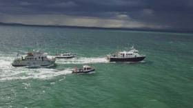
#MarineScience - A multinational team of ocean exploration experts returned to Galway on World Ocean Day (Friday 8 June) after spending the last few weeks exploring and mapping the Charlie-Gibbs Fracture Zone of the Mid-Atlantic Ridge.
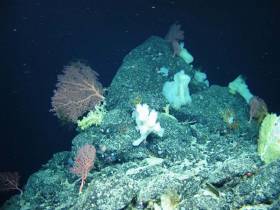
Using the robotic mini-sub ROV Holland I, the TOSCA (Tectonic Spreading and the Charlie-Gibbs Fracture Zone) research team led by Dr Aggie Georgiopoulou of UCD collected “spectacular” film footage of sponge gardens.
In another first for deep-sea exploration, the marine science team on board the RV Celtic Explorer also found more than 70 skate eggs in a nursery some 2,000 metres below the surface.
“Up to 150 rock and sediment samples amounting to roughly 200kg along with 86 hours of video footage and over 10,000 square kilometres of the zone were also mapped, which is almost the size of Co Galway and Co Mayo together,” Dr Georgiopoulou said.
The Charlie-Gibbs Fracture Zone was mapped for the first time in 2015 on the RV Celtic Explorer as one of the key projects launched by the Atlantic Ocean Research Alliance, following the signing of the Galway Statement on Atlantic Ocean Cooperation between Canada, the EU and the US in May 2013.
“The high resolution data produced by Ireland’s INFOMAR programme in 2015, that revealed spectacular landscape with 4,000m-high mounds rising from the seabed to 600m below the sea surface — taller than Carrauntoohil, Ireland’s highest mountain — has been instrumental in our continued research over the last month,” Dr Georgiopoulou said.
The tectonic spreading at the Charlie-Gibbs Fracture Zone consists of two huge parallel cracks in the crust of the Atlantic Ocean running between Ireland and Newfoundland, and is the longest-lived fracture zone in the Atlantic. It is the most prominent feature interrupting and offsetting the Mid-Atlantic Ridge.
“What we have found at the Charlie-Gibbs Fracture Zone surpassed all of our expectations,” Dr Georgiopoulou added. “Exploring three mountain areas, 500-1,000m-high scarps were discovered that have been produced by catastrophic rock avalanches, with giant boulder fields spilling into the fractures.
“Although these fracture zones are similar to the San Andreas fault in the western US and the North Anatolian fault in Turkey and Greece, with large earthquakes taking place there regularly, this is the first time there has been a dedicated geological study in the Charlie-Gibbs Fracture Zone area.”
The TOSCA expedition involved 13 scientists from nine institutions and five different countries including Ireland, the UK, Germany, Canada and Greece.
Experts in seabed mapping, marine geology, oceanography and marine biology, each team will return to their respective Institutes to analyse all the data and work out how the mountains were formed, when and how the rock avalanches take place and how the geology affects the local habitat for marine wildlife.
Marine Institute chief executive Dr Peter Heffernan congratulated the team on their recent discoveries, stating that deep ocean expeditions cannot be taken for granted as we need to better understand the features that make up the ocean seabed.
“With the ocean affecting climate change, global population and seafood demand, we need to map our seabed to define favourable habitats for fishing, key sites for conservation, and safe navigation for shipping.
“The expedition supported by AORA also reflects the value and essential role of international partnerships, particularly with achieving the shared goals of the Galway Statement on Atlantic Ocean Cooperation 2013, which include our ongoing cooperation on ocean science and observation in the Atlantic Ocean,” Dr Heffernan said.
Survey By INFOMAR to Map Seabed South of Celtic Sea
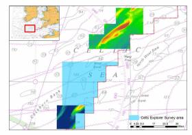
#MarineScience - Marine Institute's RV Celtic Explorer departed Galway yesterday for the first deepwater INFOMAR survey of 2018 to map the seabed in the region of the Labadie and Cockburn Banks, south of the Celtic Sea.
These areas are of ecological and economic value to the Irish fishing fleet and the data collected will allow better fisheries management decisions.
INFOMAR, the national seabed mapping programme, is a joint programme between the Geological Survey of Ireland (GSI) and Marine Institute. INFOMAR creates bathymetric charts and products for Ireland's coastal and deeper offshore waters using acoustic sonars called multi-beams. The survey team will be led by Vera Quinlan, and include four INFOMAR surveyors / scientists and four marine science students.
Three multi-beam echo sounders on the marine research vessel will transmit beams of sound towards the sea floor. These 'beams of sound' are reflected off the sea floor and both the time it takes to receive the returned signal and the intensity are captured by the on-board systems. This process provides a very clear picture of the shape and texture of the seafloor, such as the bathymetry, and the geological characteristics of the area.
Further studies include the analysis of the radiation patterns of the sonars resulting in increased precision and improved data. This is part of a long-running collaboration between INFOMAR and Professor John Hughes Clarke at the Centre for Coastal and Ocean Mapping at the University of NewINFOMAR survey to map the Celtic Sea seabed Hampshire.
The survey team includes two students from the United States of America, Alexandra Dawson and Treyson Gillespie, from the BEAMS (BEnthic Acoustic Mapping and Survey) Program. BEAMS is an undergraduate-focused training and research program from the College of Charleston's Department of Geology and Environmental Geosciences, and aims to develop a strong and qualified workforce of ocean surveyors in support of the academic, research and operational marine communities.
INFOMAR also welcomes Becky Cronin and Rachel O' Mahoney from the Training Through Research Surveys (TTRS), a collaboration with the Marine Institute. The programme aims to increase national capacity in offshore marine research by offering seagoing placements for students of marine related sciences and technologies on the national research vessels, RV Celtic Explorer and RV Celtic Voyager.
Follow INFOMAR on Facebook and Twitter for updates from the INFOMAR survey team. Also follow scientists@sea blog for some blogs during the survey.
#MarineNotice - Hydrographic and geophysical surveys will be undertaken in the Celtic Sea and Atlantic Ocean under the INFOMAR (Integrated Mapping for the Sustainable Development of Ireland’s Marine Resources) programme until October 2018.
Geological Survey Ireland vessels the RV Keary (Callsign EI-GO-9), RV Geo (Callsign EI-DK-6), RV Tonn (Callsign EI-PT-7), RV Mallet (Callsign EI-SN-9) and RV Lir (Callsign EI-HI-2) are already involved in scheduled surveys since March.
Marine Institute vessels the RV Celtic Explorer (Callsign EIGB) and RV Celtic Voyager (Callsign EIQN) will begin surveys this weekend, starting with the former vessel on a three-week survey from Sunday 22 April.
The Celtic Voyager and the Celtic Explorer will be towing a magnetometer sensor with a single cable of up to 200 metres in length. The vessels will display appropriate lights and markers, and will be listening on VHF Channel 16 throughout the course of the surveys.
Details of co-ordinates for these surveys are included in Marine Notice No 18 of 2018, a PDF of which is available to read or download HERE.
Note that the Atlantic Ocean Area may not be surveyed in 2018, but if for operational reasons the survey does take place, it will be during the dates set out above for the Celtic Voyager surveys listed therein. In that event, the Marine Notice will be updated with specific dates.
Celtic Voyager Explores Irish Sea’s Lost landscapes
#MarineScience - An Irish research team from IT Sligo and University College Cork recently joined the ‘Europe’s Lost Frontiers’ project to explore the extensive submerged landscapes in the Irish Sea aboard the Marine Institute’s Celtic Voyager research vessel research vessel.
Following the last Ice Age, large areas of habitable land were inundated following climate change and sea level rise across the world. Globally, the sea level rose around 120 metres and an area more than twice that of the modern United States of America was lost to the sea.
Beneath the waves of the Irish Sea is a prehistoric ‘palaeolandscape’ of plains, hills, marshlands and river valleys in which evidence of human activity is expected to be preserved.
This landscape is similar to Doggerland, an area of the southern North Sea and currently the best known example of a palaeolandscape in Europe. Doggerland has been extensively researched by Prof Vince Gaffney, principal investigator of the Europe’s Lost Frontiers project.
“Research by the project team has also provided accurate maps for the submerged lands that lie between Ireland and Britain,” said Prof Gaffney, “and these are suspected to hold crucial information regarding the first settlers of Ireland and adjacent lands along the Atlantic corridor.”
To provide this evidence, sediment from some 60 cores, taken from 20 sites by the RV Celtic Voyager in Liverpool and Cardigan Bays between the 21 and 25 February, will be studied by an international marine research team.
Dr James Bonsall, from the Centre for Environmental Research Innovation and Sustainability (CERIS) in the Department of Environmental Science at IT Sligo, was chief scientist for this phase of the research, and together with his CERIS colleague, environmental scientist Eithne Davis, directed operations on board the RV Celtic Voyager.
“It is very exciting,” said Dr Bonsall, “as we’re using cutting-edge technology to retrieve the first evidence for life within landscapes that were inundated by rising sea levels thousands of years ago.
“This is the first time that this range of techniques has been employed on submerged landscapes under the Irish Sea. Today we perceive the Irish Sea as a large body of water, a sea that separates us from Britain and mainland Europe, a sea that gives us an identity as a proud island nation. But 18,000 years ago, Ireland, Britain and Europe were part of a single landmass that gradually flooded over thousands of years, forming the islands that we know today.
“We’re going to find out where, when, why and how people lived on a landscape that today is located beneath the waves.”
Key outcomes of the research will be to reconstruct and simulate the palaeo-environments of the Irish Sea, using ancient DNA, analysed in the laboratories at the University of Warwick, and palaeo-environmental data extracted from the sediment cores.
The studies will be of immense value in understanding ‘first’ or ‘early’ contact and settlement around the coasts of Ireland and Britain, but also the lifestyles of those people who lived within the inundated, prehistoric landscapes that lie between our islands and which have never been adequately explored by archaeologists.
The Celtic Voyager and the Marine Institute’s expertise were provided to explore the extensive submerged landscapes, where marine core samples were taken. Technical support setting up the seabed survey and navigation systems was also provided by members of the DCCAE-funded INFOMAR team, who specialise in bathymetric mapping and geophysical survey.
This research survey was carried out with the support of the Marine Institute, funded under the Marine Research Programme 2014-2020 by the Irish Government.
Europe’s Lost Frontiers is an ERC-funded Advanced Grant project based at the University of Bradford. Aimed at understanding the transition between hunter gathering to farming in north-west Europe, the project is studying the evidence for inundated palaeolandscapes around the British coast using seismic reflectance data sets to generate topographical maps of these ‘lost lands’ that are as accurate and complete as possible.
Environmental data from these areas is then being used to reconstruct and simulate the palaeo-environments of these landscapes using ancient DNA extracted directly from sediment cores as well as traditional environmental evidence.
INFOMAR Contributes €24.6 million to Irish Economy
The INFOMAR programme, jointly managed by the Marine Institute and Geological Survey Ireland and funded by the Department of Communications, Climate Action and Environment held its annual seminar in Cork (15th – 16th November), highlighting the impact and value of Ireland's national seabed mapping programme.
The event, attended by representatives from leading industry, government and research organisations, was held in partnership with National Maritime College of Ireland (NMCI) who hosted the conference focused on 'Collaborating for better marine resource management'.
Koen Verbruggen, Director of Geological Survey of Ireland, highlighted a report just published by Indecon International Economic Consultants, 'An Economic Review of the Irish Geoscience Sector', which shows INFOMAR has contributed €24.6 million to the Irish economy in 2016 across four sectors examined.
Michael Gillooly, Director of Ocean Science and Information Services at the Marine Institute underlined the importance of collaboration to optimise delivery of quality science and knowledge to inform decision making. Mr Gillooly said, "INFOMAR data and associated value added programmes, in which INFOMAR plays a central role, will enable delivery of integrated marine data outputs and services, such as the Integrated Digital Ocean which will be used by government, industry, researchers and the general public'
Thomas Furey, Marine Institute joint INFOMAR programme manager noted, "There has been extensive progress and success in mapping, and associated research and innovation, however three specific challenges remain for INFOMAR in the years ahead:
• Dealing with Brexit in the context of our maritime boarders and transboundary issues associated with the Marine Strategy Framework Directive & Marine Spatial Planning;
• Achieving regional scale integrated coastal zone land to sea mapping given the associated technology challenges, and;
• Leveraging Ireland's leading role in seabed & habitat mapping to provide Irish partnership delivered products and services on the global market."
Sean Cullen, Geological Survey of Ireland joint INFOMAR programme manager said, "Ireland is recognised internationally for its leadership role in mapping and marine data management, and increasing our collaboration and knowledge sharing in operations and innovation will provide significant opportunities for growth of Irish industries and jobs, and allow us to deliver the best science and knowledge based resource and risk management decisions into the future."
The event provided an open, informative and engaging platform bringing together Ireland's key marine stakeholders including speakers from the Marine Institute, Geological Survey Ireland; UAV Mapping & Coastal Heritage, National University, Galway; University College, Dublin; University College, Cork; AAIU; IMDO; MaREI; SEAI; GDG; ARUP; and the OPW.
INFOMAR Seminar Takes Place In Cork Next Week
#INFOMAR - This year’s annual seminar for the INFOMAR programme will take place next Wednesday 15 and Thursday 16 November at the National Maritime College of Ireland on Cork Harbour.
The Integrated Mapping for the Sustainable Development of Ireland’s Marine Resource (INFOMAR) programme is a joint marine science venture between the Marine Institute and Geological Survey Ireland and is funded through Department of Communications, Climate Action and Environment.
‘Collaborating for Better Marine Resource Management’ is the theme of this year’s INFOMAR seminar — held in partnership with the NMCI — which aims to provide an open, informative and engaging platform bringing together Ireland's key marine stakeholders.
The format will include quality presentations, demonstrations and networking opportunities. See the seminar agenda for the two days, and register for the free event via Eventbrite.
Offshore Earthquakes & Deep Sea Corals Among 26 Projects Awarded €45m By SFI
#MarineScience - Offshore earthquakes and cold water coral in subsea canyons in Irish waters are among 26 projects awarded €45 million in research investment through the Science Foundation Ireland's Investigators Programme, announced last week by Minister of State for Training and Skills, John Halligan.
“This funding recognises some of Ireland’s top researchers and enables them to advance vital research areas in Ireland,” said the minister. “I am confident that the teams being supported will generate important new scientific breakthroughs.”
The 26 research projects will support 94 research positions over the next five years.
“In addition, today’s investment provides 20 companies with access to invaluable expertise and infrastructure across the country,” said Minister Halligan. “These collaborations between industry and academia are integral to further enhancing Ireland’s reputation for research excellence.”
To strengthen and accelerate research in key strategic areas of national interest, Science Foundation Ireland (SFI) collaborates with several funding agencies and public bodies through the SFI Investigators Programme.
Six of the research projects received co-funding worth a total of €3 million from Teagasc, the Geological Survey of Ireland, the Marine Institute, and the Environmental Protection Agency. The Marine Institute and the Geological Survey of Ireland are co-funding two marine science awards with SFI to the value of €2.65 million.
Professor Sergei Lebedev of the Dublin Institute of Advanced Studies (DIAS) has been awarded €1,248,989 to investigate the structure, evolution and seismic hazard of Ireland’s offshore territory.
With 90% of Ireland’s territory offshore, it represents vast resources but also hazards, with offshore earthquakes posing the biggest risk with the potential to trigger undersea landslides and tsunamis.
Prof Lebedev’s team will for the first time deploy an array of ocean-bottom, broadband seismometers offshore which, together with existing arrays onshore, will cover the entire Irish territory.
Professor Andy Wheeler of University College Cork has been awarded €874,329 to explore and monitor cold water corals in submarine canyons in the deep ocean and determine their sensitivity to climate change and fisheries and oil industry impacts.
Prof Wheeler’s team will used advanced robotic technology and novel 3D visualisation and will make recommendations for sustainable responsible fisheries and hydrocarbon activity and for effective management during climate change.
Dr Ciaran Kelly, R&D manager at the Marine Institute, said, “The Marine Institute is delighted to partner with SFI again in co-funding these important projects through the investigators programme, together with our INFOMAR programme partners, Geological Survey of Ireland.
“This collaboration will accelerate our knowledge of key processes of the deep ocean bringing longstanding benefits to society.”
For more information on the 26 projects funded through the SFI Investigators Programme see www.sfi.ie.
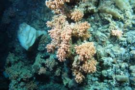
New Expedition Finds Deepest Ever Irish Corals

#MarineScience - A team of scientists have discovered the deepest known occurrence of a cold water coral reef known as Solenosmilia variabilis in Irish waters.
The marine scientists, led by the Marine Institute with the National Parks and Wildlife Service (NPWS), travelled over 1,000 nautical miles over three weeks along Ireland's Porcupine Bank and continental slope collecting HD video, sample cores and biological specimens from marine wildlife along the shelf edge from 50 locations.
They also explored the Atlantic Ocean to depths of more than 1,600 metres as part of a multi-agency and university collaboration using video mapping with the Marine Institute’s mini-submarine ROV Holland I.
The SeaRover survey was carried out on the Commissioner of Irish Lights vessel ILV Granuaile, gathering data for marine planning, habitat protection and measuring the effects of climate change.
“Some of the reef ecosystems and habitats we discovered have never been seen before, and discovering S. variabilis at depths greater than 1,600m helps us establish a better understanding of the environmental conditions necessary for this species to thrive,” said INFOMAR chief scientist David O’Sullivan.
"The deep-sea coral S. variabilis is widespread, normally seen at depths between 1,000 to 1,300m on seamounts or rocky areas deep under the sea but only occasionally forms reefs.
“Its growth rate is very slow approximately one millimetre per year, so finding the reef structure, which is part of a fragile ecosystem thousands of years old, in deeper parts of the ocean is an important find for marine science.”
Also found in this extreme deep sea environment were sea pens, which visually look like a cross between a feather, a starfish and a fern, but are are actually a form of soft coral.
“With over 300 species currently known around the world, they come in a variety of shapes, sizes and colours — we have seen a wide variety of forms on this survey, and can only give species names to very few as many are likely to be new to science and have yet to be described,” said Dr Yvonne Leahy of the NPWS.
“There are undoubtedly many more unidentified species out there and we ourselves have observed some specimens that require closer examination to properly identify.”
The team used the ROV Holland 1 to map the distribution and extent of deep water reefs and associated habitats, as well as using high-resolution bathymetric maps produced under the national seabed mapping programme INFOMAR, a joint initiative of the Marine Institute and the Geological Survey of Ireland.
The bathymetric data, which shows the depths of the ocean, has been key in identifying specific seabed features such as submarine canyons, escarpments and mounds where reef habitats are likely to occur.
The SeaRover (Sensitive Ecosystem Assessment and ROV Exploration of Reef Habitat) survey is jointly funded by the Government and the EU through the European Maritime Fisheries Fund and NPWS to undertake further mapping surveys of offshore reefs, with the aim of evaluating status and review requirements for conservation and management measures consistent with the Habitats Directive.
The project is co-managed by the INFOMAR programme and Fisheries Science and Ecosystem Services at the Marine Institute and NPWS. While the project objectives are primarily policy driven, the collection of data and scientific benefit will also be of immense benefit to the national and international research community.
The ROV robotic arms were also used to collect biological specimens for NUI Galway's SFI funded project ‘Exploiting and Conserving Deep Sea Genetic Resources’, and will also give new information on where sensitive species are found to help research at University of Plymouth’s Deep Sea Conservation Unit to predict where high value ecological areas might be identified offshore of Ireland and the wider North East Atlantic.
“The biological samples will help us understand the connectivity of different cold-water coral reef habitats, which will ultimately help with their future management,” said on-board senior scientist Dr Kerry Howell from Plymouth University.
This latest research mission comes less than two months after a team of university researchers and students on the RV Celtic Explorer explored cold water corals and sponges in the Whittard Canyon on the south-western edge of the continental shelf.
First Of Six INFOMAR Seabed Surveys In 2017 Completed

#MarineScience - The Marine Institute’s RV Celtic Voyager returned to Cork Harbour last week after the first of six INFOMAR seabed mapping surveys planned for 2017.
The two-week seabed survey carried out its operations in the Celtic Sea south of the Waterford and Wexford coastlines.
The research team — involving geophysicists, geologists, marine biologists and data processors Kevin Sheehan, David O'Sullivan, Oisin McManus, Nicola O'Brien and Michael Arrigan — were tasked to accurately map the physical, chemical and biological features of the seabed area.
INFOMAR survey operations are conducted by a fleet of research vessels — including the RV Celtic Voyager, which is used for mapping seabed terrain in water depths between 20m and 100m.
The vessels are equipped with advanced mapping technologies including state-of-the-art acoustic sonars, geophysical instrumentation and ground-truthing capabilities, as well as geophysical equipment and precise satellite positioning.
“This helps to ensure data collection is of the highest possible quality across a wide range of water depths, conditions and environments, providing us with full coverage mapping of the shape and type of the seabed below,” says David O'Sullivan.
The INFOMAR survey around Ireland is one of the largest civilian seabed mapping projects in the world and aims to gather high resolution seabed data that contributes to the sustainable development of Ireland's marine resource.
As an island nation, Ireland is responsible for the sustainable management of its marine resources and it is important that accurate seabed maps are created to enable effective governance.
“Gathering up-to-date information about our ocean is cognisant of ensuring we have the best available science and knowledge to inform decisions affecting our ocean, particularly in relation to fisheries management and the development of ocean energy,” added O’Sullivan.
The INtegrated Mapping FOr the Sustainable Development of Ireland's MArine Resource (INFOMAR) programme is a joint venture between the Geological Survey of Ireland and the Marine Institute, funded by the Department of Communications, Climate Action and Environment.
Seabed Mapping Seminar In Galway Next Week
#INFOMAR - Galway’s Marine Institute hosts the 2016 Seminar for INFOMAR – Integrated Mapping for the Sustainable Development of Ireland’s Marine Resource – next Wednesday 19 October.
With a focus on ‘collectively creating an INFOMAR legacy’, the free day-long event will look back on the development and impact of seabed mapping in Ireland, as well as plans for completion of the coastal and shelf-mapping project, and optimising the use and value of knowledge gained from mapping data.
The morning’s two main sessions include a ‘birds eye view’ of mapping the seas of Ireland’s Exclusive Economic Zone, and exploring the latest mapping technology for coastal development and management.
Afternoon presentations will also look at INFOMAR’s role the in energy, infrastructure, environment and education sectors.
The full seminar agenda is online, and free registration is available HERE.


, and Dermot O’Kane, Head of Sales, Esri Ireland. Esri Ireland is announcing that its digital mapping system is helping DURL to prevent 13 million litres of polluted wastewater from entering Dublin rivers annually, by locating misconnected household appliances that are expelling polluted water")


 Michael Murphy Schull Harbour Sailing Club (SHSC), Eric Coogan Heineken Ireland, Mark Murphy, Commodore SHSC, Jack Allen SHSC, Carmel O'Regan SHSC, Cornelious Ndlovu, Schull Harbour Hotel Operations Manager and Derval Murphy SHSC")


