Menu

Ireland's sailing, boating & maritime magazine

Inland afloat headers


Displaying items by tag: Inshore

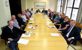
#Fishing - A new website for the National Inshore Fisheries Forums (NIFF) was launched by Marine Minister Michael Creed yesterday (Tuesday 25 October).

“Getting inshore fishing communities involved in decision-making is the key aim of the forum initiative,” said the minister, who added that the website “is a vital tool both to make information available and also to foster interaction and discussion.

“I hope that it will become a regular port of call for all interested in developing a sustainable future for this sector.”

Minister Creed also thanked Bord Iascaigh Mhara and the forum delegates for their contributions to the website at www.inshoreforums.ie, launched at the eighth meeting of the NIFF since it was established in 2014.

Budget 2017’s introduction of the Fisher’s Tax Credit (based on the seafarer’s allowance model) and changes to the Fish Assist Scheme were highlighted as important income support mechanisms for inshore fishing communities.

The inshore sector — comprising fishing boats of less than 12 metres in overall length — makes up more than 80% of the fishing fleet, and is predominately active within six nautical miles of the Irish shore.

Minister Creed acknowledged the role of the NIFF and others in the fishing industry in advocating for income support.

“Maintaining jobs and attracting new entrants have been identified by our stakeholders as a key challenge for our fishing industry, including the inshore sector,” he said.

“This annual tax credit specifically for fishermen of €1,270, which mirrors the value of the Seafarer’s allowance, is important recognition for their contribution to Ireland’s Blue Economy.”

Yesterday’s NIFF meeting also tabled proposals to revise the conservation measures for lobster, and to introduce technical conservation measures for the velvet crab fishery.

Published in Fishing
Tagged under

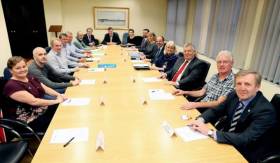
#Fishing - New Minister for Agriculture, Food and the Marine Michael Creed hosted his first meeting of the National Inshore Fisheries Forum (NIFF) yesterday, Wednesday 22 June.

The minister met with the chairs and vice-chairs representing the six Regional Inshore Fisheries Forums (RIFFs) to hear their proposals for the future development of the inshore fisheries sector.

The inshore sector – comprising fishing boats of less than 12m in overall length – make up more than 80% of the fishing fleet and are predominately active within six nautical miles of the Irish shore.

“I am pleased that there was a focus in today’s discussions on priorities to ensure a positive longterm future for this sector," said Minister Creed. "This Government has committed to the development of the inshore sector. To deliver this, it is essential to hear the views of the stakeholders themselves through the NIFF.

"With EMFF funding now available, there are opportunities to secure sustainable inshore fisheries and enhance incomes in rural, coastal communities.” Among the range of issues discussed at yesterday’s meeting were access to herring stocks, and proposals to develop national conservation measures for velvet crab.

This was the seventh meeting of the NIFF (not to be confused with the National Inland Fisheries Forum), which was established in 2014 to facilitate the development of a coherent inshore sector 'voice' by encouraging inshore fishermen to discuss their fishing issues and generate commonly-supported initiatives.

A network of six Regional Inshore Fisheries Forums (RIFFs) around the Irish coast have nominated delegates to bring forward regional proposals to the NIFF for wider industry discussion.

These RIFF members include inshore fishermen, environmental interests, marine leisure, marine tourism and other marine stakeholders.

The structures also provide opportunities for collaboration between the inshore fishing sector and their communities on sustainable strategies to optimise the income opportunities afforded by the coastal resource.

Published in Fishing
Tagged under

#fishermen – The Minister for the Marine, Simon Coveney T.D. today hosted the first meeting of the National Inshore Fisheries Forum (NIFF), bringing together for the first time a network of representatives from the six recently established Regional Inshore Fisheries Forums. The inshore sector (comprising fishing boats of less than 12 metres in overall length) make up more than 80% of the fishing fleet and are predominately active within six nautical miles of the Irish shore.

Speaking ahead of the first NIFF meeting the Minister said: "In May last year I announced a package of measures to support the sustainability and viability of the inshore fisheries sector. I have long been concerned that Ireland's inshore fishermen have been poorly represented in national policy making structures and to address that deficit, and as part of the package of measures, I took the innovative step of setting up of the forum initiative. I am delighted that inshore fishermen are buying into this opportunity to focus the priorities on what is needed to ensure the long term future in their sector. I look forward to appointing the first Chair and Vice-Chair at today's meeting."

The NIFF has been set up to facilitate the development of a coherent inshore sector "voice" by encouraging inshore fishermen to discuss their fishing issues and generate commonly-supported initiatives. A network of Regional Inshore Fisheries Forums (RIFFs), based on and linked to the community-led Fisheries Local Action Groups (FLAGs) around the Irish coast, have nominated delegates to bring forward regional proposals to the NIFF for wider industry discussion. The RIFF members include inshore fishermen, environmental interests, marine leisure, marine tourism and other marine stakeholders. The structures also provide a new opportunity for collaboration between the inshore fishing sector and their communities on sustainable strategies to optimise the income opportunities afforded by the coastal resource.

Michael Keatinge, BIM's Interim CEO and Fisheries Development Director stressed the value of the NIFF to the sector; 'This is a unique opportunity to develop our valuable inshore fishery not just in terms of short term improvements but to ensure the long term sustainability of our stocks which in turn will protect revenue and employment in our fishing reliant coastal communities. Today's meeting is a positive step forward in this regard and the issues discussed including conservation, enforcement and the collation of landings data will enable this industry to be best placed to secure a viable future. I am pleased to say that our industry's commitment to conservation is clear with a phenomenal response to the BIM Lobster V-notching Scheme last year with over 33,000 lobsters v-notched compensating fishermen to the tune of more than €250,000 and we are expecting an even greater response this year. BIM are looking forward to assisting the Minister, the Department and industry to ensure this initiative plays a key role in the development of our inshore fishing sector'

Challenges facing the inshore sector including the reformed CFP and protecting Natura 2000 sites as well as feedback from the recent consultation on a proposed management plan for razor clam fishing in the North Irish Sea were discussed at today's meeting. Other important fisheries for the inshore sector for discussion included lobster, crab and opportunities for diversification to maintain a viable inshore sector.

Published in Fishing
Tagged under

#inshorefisheries – Following the launch of the National Inshore Fisheries Forum (NIFF) earlier this year by the Minister for Agriculture, Food and Marine, Mr. Simon Coveney T.D. and the recent agreement on the terms of reference for the forum; BIM are now seeking members to take part in the Regional Inshore Fisheries Forums (RIFFs). Each RIFF will feed into the National Inshore Fisheries Forum and will link with the existing infrastructure of the Fisheries Local Action Groups or FLAG's programme. There are six FLAG's established in coastal regions around Ireland.
The RIFFs will comprise of no more than 12 members.
A minimum of 8 members will represent the inshore fisheries sector and will be appointed on the basis of:
their ability to represent the views of the inshore sector
their knowledge of inshore fisheries, fish stocks, and fishing methods, and
their capacity to engage on fisheries management issues.
In addition, the FLAG will aim to ensure that the membership is representative of the FLAG region's geographical coverage and the characteristics of the region's inshore fleet and fisheries. Applicants must demonstrate support within their respective sector for their nomination to a forum. The balance of the membership will include stakeholders from marine sectors other than fisheries, such as seafood processing/sales, marine leisure, marine tourism, environmental NGOs and community organisations.
Should the FLAGs consider a sector or area is lacking in representation the FLAG reserves the right to approach appropriate individuals or organisations to seek members.
If you are interested in applying for membership of the RIFFs, please e-mail Caroline Curraoin in BIM [email protected] or send your application by post to FLAG Co-ordinator, BIM, , P.O. Box 12, Crofton Rd., Dun Laoghaire , Co. Dublin. Full details on the terms of reference for the National Inshore Fisheries Forum are available on www.bim.ie
The closing date for all applications is Friday, 29th August 2014.

Published in BIM
Tagged under

#Fishing - Marine Minister Simon Coveney has announced a package of measures to develop the inshore fisheries sector.

The package is targeted at the inshore fishing sector and consists of three parts including the establishment of a National Inshore Fisheries Forum, supported by a network of Regional Inshore Forums in each of the Fisheries Local Action Group (FLAG) regions.

There will also be a funding programme worth up to €1m for the inshore sector, and conservation measures to support lobster and shrimp stocks.

The inshore sector (fishing boats of less than 12m overall length) comprises over 80% of the fishing fleet and is predominately active within 6 nautical miles of the shore.

Announcing the establishment of the National Inshore Fisheries Forum (NIFF), the minister said: “Ireland’s inshore fishermen are poorly represented by current structures and need a dedicated platform where they can discuss and develop common initiatives.

"I hope that inshore fishermen will embrace this opportunity created by the new structures to have a coherent voice which can be heard clearly.”

The NIFF is being set up to encourage inshore fishermen using small fishing boats to participate in the management of their fisheries. 

A network of Regional Inshore Forums (RIFs), based on and linked to the community-led FLAGs around the Irish coast, will nominate delegates to bring forward regional proposals to the NIFF for wider industry discussion. The structures will also provide a new opportunity for future consultation with the inshore fishing sector.

Meanwhile, Minister Coveney committed to a total funding programme for inshore fishermen in 2014 worth up to €1m. This is aimed at providing financial assistance for sustainable, environmentally friendly fishing practices and the recent safety equipment and training initiative.

Support will be available under the new Sustainable Inshore Fisheries Scheme for a range of measures including:

  • An enhanced v-notching programme with increased coverage around the coast (grant aid increased from current maximum 55% to 75%);
  • Gear and equipment to support responsible fishing practices (such as mackerel jigging, potting for crayfish); abd
  • Improvements in the area of quality, hygiene, and standards on board.

A supplementary Shellfish Pot Replacement Scheme will also be launched to provide extended assistance to fishermen who lost pots during the exceptional winter storms, more than doubling the pot limits from 50 to 200 for boats less than 12m length and from 100 to 250 for boats from 12 to 15m in length.

Existing applicants to the current scheme will automatically be increased to the supplementary pot limits and a call for new applications will be advertised.

Following on extensive consultation in 2013, the minister also approved plans to revise conservation measures for lobster and shrimp.

Given the importance of very large lobsters to the reproductive potential of the stock, a maximum landing size for lobster of 127mm will be introduced by legislation in the coming months.

During the first two years of operation of this new measure, fishermen will be paid up to 75% of the market price for v-notching ‘oversize’ lobsters and returning them live to sea. In addition the grant aid for voluntary V notching of Lobsters is being increased from the existing maximum of 55% to a new maximum of 75%.

In addition, a revised closing date for the shrimp fishery of 15 March instead of 1 May will commence from 2015 to provide stock protection during the spawning period.

Minister Coveney said: “I am asking the Regional Inshore Forums, as a first initiative, to identify lobster stock enhancement areas within their regions where hatchery-grown juveniles could be released. Lobsters are one of the most important species to the inshore sector and we need to dedicate resources to ensure the long-term future of this valuable stock. 

"I have also asked BIM to work with the Marine Institute to develop a pilot project for a national lobster hatchery as an additional conservation tool.”

Published in Fishing
Tagged under

#ANGLING - An "eagle-eyed" angler in Co Cork received a free eye test after his remarkable find of a wedding ring in the water last week.

Seventy-five-year-old Pat O'Flaherty spotted the €400 gold band - complete with its red box - in the River Lee, garnering him a front-page story in the Irish Examiner and a free eye test from Specsavers.

They put me in the chair and did all the tests and told me I have 20:20 vision," he said.

The owner of the ring has yet to be traced, despite much speculation as to how it ended up in the Lee in the first place. If unclaimed, O'Flaherty intends to auction the ring for charity.

In other angling news, West Cork's Courtmacsherry Angling Centre hosted members of the Bradford Sea Angling Club in the UK last weekend.

Poor weather meant that the group was restricted to inshore fishing on the Friday and Saturday, but the Sunday saw a catch of ling up to 23lbs as well as pollack, coalfish, cod, haddock and whiting.

Published in Angling

#MARINE WILDLIFE - The Irish Whale and Dolphin Group has confirmed the sighting of a humpback whale off Achill Island in Co Mayo last weekend.

Surfers off Keel Beach were credited with the discovery, after spotting a large whale of 30-60ft breaking the surface multiple times, lifting its tail fluke vertically.

The sighting is only the fifth validated record of a humpback whale off the coastal area from Galway to Donegal.

"It remains something of a mystery as to why sightings of this species remain such relatively rare events along our west and northwest compared to our south and southwest coasts," says IWDG sightings co-ordinator Pádraig Whooley.

"This latest sighting is a timely reminder that species such as humpbacks can and do turn up in places that are well outside what we perceive to be the known 'hotspots'."

Humpback whales tend to feed in inshore waters, which should make them increasingly easier for the public to spot from the shore, he added.

The IWDG has more on the story HERE.

Published in Marine Wildlife
Spectacular photographs taken from the shore by Lifeboat Operations Manager John Brittain during Clifden RNLI's special surf training recently on Dunloughan beach show the type of conditions that volunteer lifeboat crew train in for the life-saving charity. The shots capture the inshore lifeboat crewmembers climbing a wave and exercising in some choppy conditions.

John organised the training in response to the increased popularity of the area with surfers.  RNLI Divisional Assessor Trainer Helena Duggan travelled to the lifeboat station to put 18 volunteer lifeboat crew through their paces and train them in handling the lifeboat in surf and responding to potential callouts from leisure marine enthusiasts.

Training is a core part of volunteering with the RNLI and each crewmember in Clifden trains once a fortnight on the stations two inshore lifeboats.

Commenting on the exercise John said, "I took my camera down to photograph the exercise and was really pleased with the results.  It is great to be able to show the public what our lifeboat volunteers go through to ensure they are fit and trained to go to sea. We had a fantastic turnout on the day and the lifeboat crew learned about boat handling in surf conditions. We are delighted so many people are visiting the area for leisure marine activities."

clifden_d_class_1

clifden_d_class_2

clifden_d_class_3

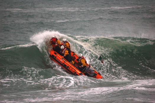
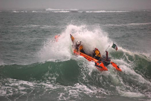
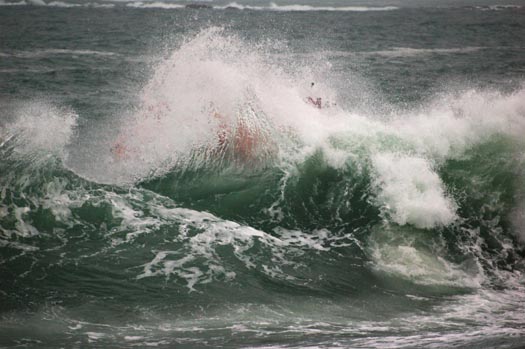
Photos by John Brittain/Clifden RNLI show Clifden volunteer lifeboat crew with RNLI Training assessor Helena Duggan during surf training on Dunloughan beach, Ballyconeely

Related Safety posts

RNLI Lifeboats in Ireland


Safety News


Rescue News from RNLI Lifeboats in Ireland


Coast Guard News from Ireland


Water Safety News from Ireland

Marine Casualty Investigation Board News

Marine Warnings

Published in RNLI Lifeboats
Proposals for ten potential conservation zones in the Irish Sea are earmarked in a second report released from the Irish Sea Conservation Zones project.

The area include the inshore waters of Merseyside, Lancashire and Cumbria and offshore waters of the Isle of Man, Wales, Northern Ireland and England. One of the zones is a 187 square km stretch of deep water between Northern Ireland and the Isle of Man.

In order to gain a greater understanding of the proposed zones, the report commissioned a Regional Stakeholder Group which drew from a diverse range of interests in the Irish Sea. Among the stakeholders included were the Royal Yachting Association, the fishing community and ports authorities. The review identified the size, shape and locations of the proposed 10 ten new Marine Conservation Zones. For the first time, the zones included inshore water of the Irish Sea project area as well as offshore.

"This is a real milestone for the project, with potential Marine Conservation Zones identified in both inshore and offshore waters", said Greg Whitfield, project manager at Irish Sea Conservation Zones.

"It is now really important that people take a look at the potential zones and give us their feedback on them. The better the information we have, the better the Marine Conservation Zones that are recommended by the regional stakeholder group will be."

Each of the marine conservation zones are designed to protect nationally important marine wildlife, habitats and geology. In addition they are designed to have the least impact possible on people's activities, but some restrictions will apply as the zones must meet guidelines for protecting species and habitats.

Members of the public are being invited to participate and will be considered as the second project continues to refine its proposals. The report is only a snapshot of the work so far. It does not contain concrete recommendations for the locations of Marine Conservation Zones (MCZ) in the Irish Sea, and the potential zones shown in the report are described as tentative and liable to change.

The Irish Sea Conservation Zone project will be releasing a third report before the Regional Stakeholder Group finalises its recommendations. The reports are delivered to the Science Advisory Panel. The independent body is comprised of expert scientists whose main role is to evaluate the potential of MCZs against ecological criteria.

The third progress report will be made available in February 2011. Its final recommendations will then be presented to the UK government in June. Following that a formal public consultation on the proposed MCZs are to take place in late 2011 and early 2012.

For information on the Second Progress Report including feedback forms can be downloaded from HERE or by calling 00 44 (0)1925 813 200
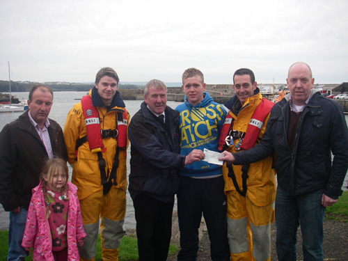
Published in Marine Science

A grateful family presented a cheque to Portrush lifeboat crew in thanks for saving their son this summer.
On 16th May 2010 both Portrush Lifeboats were launched to two separate incidents within one at 0922 hours and one at 0924 hours.
Within minutes two full volunteer crews had assembled and both the All-weather Lifeboat and the Inshore Lifeboat were launched. The Inshore Lifeboat was launched to reports of two young people in the water at Dhu Varren. Karl O'Neill was at the helm supported by Nick Christie and Jonathan Weston. Two youths had gone into the sea after a dog, and were starting to experience real difficulties in getting back to shore. One of the youths Damian Morris had sustained cuts to his arms and legs, was suffering hypothermia and was literally going under the water for the third time when the Portrush Lifeboat arrived on scene. Damian spent several days in hospital as a result of the incident and was delighted to be able to come to the station to meet the crew who had saved him that day.
Damian's uncle and Godfather Raymond Comac and his friend Paul McGuigan, do a lot of charity work in Damian's hometown in Omagh holding fundraisers to raise funds to take motorbikes out to South Africa for use by health care workers in the townships. However this year, they divided the proceeds between their charity and the RNLI, in recognition of the fact that the volunteer crew at Portrush had saved Damian's life.
Damian's parents Liam and Rosemary Morris, Damian himself and his uncle Raymond and friend Paul travelled to Portrush to meet the crew and hand over a cheque for £1000. Both Nick and Karl were overwhelmed by the generosity and stated;
'We don't do this for thanks, but it's so nice to meet someone that you have helped and for this amount to be raised is fantastic for the station'
The family got a tour of the station and had a look at the new Inshore lifeboat 'The David Roulston' which took over from the 'Ken and Mary' the boat that responded to the call that day....one of her last launches.

Cheque_Presentation_Nov_2010_055

Related Safety posts

RNLI Lifeboats in Ireland


Safety News


Rescue News from RNLI Lifeboats in Ireland


Coast Guard News from Ireland


Water Safety News from Ireland

Marine Casualty Investigation Board News

Marine Warnings

Published in RNLI Lifeboats

General Information on using Waterways Ireland inland navigations

Safety on the Water

All users of the navigations are strongly recommended to make themselves aware of safety on the water for whatever activity they are involved in and to read the advice offered by the various governing bodies and by:

The Dept. of Transport, Ireland: www.gov.ie/transport and The Maritime and Coastguard Agency, UK, The RNLI – Water Safety Ireland for information in terms of drowning prevention and water safety.

Registration of Vessels

All vessels using the Shannon Navigation, which includes the Shannon-Erne Waterways and the Erne System must be registered with Waterways Ireland. Only open undecked boats with an engine of 15 horsepower or less on the Shannon Navigation, and vessels of 10 horsepower or less on the Erne System, are exempt. Registration is free of charge.

Craft registration should be completed online at: https://www.waterwaysireland.org/online-services/craft-registration

Permits for use of the Grand and Royal Canals and the Barrow Navigation

All vessels using the Grand and Royal Canals and the Barrow Navigation must display appropriate valid Permit(s) i.e A Combined Mooring and Passage Permit (€126) and if not intending to move every five days, an Extended Mooring Permit (€152).

Permit applications should be completed online at: https://www.waterwaysireland.org/online-services/canal-permits

Passage on the Royal and Grand Canals – Dublin Area

For boat passage through the locks east of Lock 12 into / out of Dublin on either the Royal or Grand Canals, Masters are requested to contact the Waterways Ireland Eastern Regional Office (M-F 9.30am-4.30pm) on tel: +353(0)1 868 0148 or email [email protected] prior to making passage in order to plan the necessary lock-keeping assistance arrangements.

On the Grand Canal a minimum of two days notice prior to the planned passage should be given, masters should note that with the exception of pre-arranged events, a maximum of 2 boats per day will be taken through the locks, travelling either east or west.

Movements in or out of the city will be organised by prior arrangement to take place as a single movement in one day. Boaters will be facilitated to travel the system if their passage is considered to be safe by Waterways Ireland and they have the valid permit(s) for mooring and passage.

Newcomen Lifting Bridge

On the Royal Canal two weeks’ notice of bridge passage (Newcomen Lifting Bridge) is required for the pre-set lift date, and lock assistance will then also be arranged. A minimum of 2 boats is required for a bridge lift to go ahead.

Waterways Ireland Eastern Regional Office (Tel: +353(0)1 868 0148 or [email protected] ) is the point of contact for the bridge lift.

A maximum number of boats passing will be implemented to keep to the times given above for the planned lifts (16 for the Sat / Sun lifts & 8 for the weekday lifts). Priority will be given on a first come first served basis.

On day of lift, boaters and passengers must follow guidance from Waterways Ireland staff about sequence of passage under bridge & through Lock 1, and must remain within signed and designated areas.

Events Held on the Waterways

All organised events taking place on the waterways must have the prior approval of Waterways Ireland. This is a twelve week process and application forms must be accompanied with the appropriate insurance, signed indemnity and risk assessment. The application should be completed on the Waterways Ireland events page at :

https://www.waterwaysireland.org/online-services/event-approval

Time Limits on Mooring in Public Harbours

On the Shannon Navigation and the Shannon-Erne Waterway craft may berth in public harbours for five consecutive days or a total of seven days in any one month.

On the Erne System, revised Bye Laws state that: No master or owner shall permit a vessel, boat or any floating or sunken object to remain moored at or in the vicinity of any public mooring, including mooring at any other public mooring within 3 kilometres of that location, for more than 3 consecutive days and shall not moor at that same mooring or any other public mooring within 3 kilometres of that location within the following 3 consecutive days without prior permission by an authorised official.

Winter Mooring on the Shannon Navigation and Shannon Erne Waterway

Winter mooring may be availed of by owners during the period 1 Nov to 31 Mar by prior arrangement and payment of a charge of €63.50 per craft. Craft not availing of Winter Mooring must continue to comply with the “5 Day Rule”. Winter Mooring applications should be completed online at : https://www.waterwaysireland.org/online-services/winter-moorings-booking

Owners should be aware that electricity supply and water supply to public moorings is disconnected for the winter months. This is to protect against frost damage, to reduce running costs and to minimise maintenance requirements during the winter months.

Vessel owners are advised that advance purchasing of electricity on the power bollards leading up to the disconnection date should be minimal. Electricity credit existing on the bollards will not be recoverable after the winter decommissioning date. Both services will be reinstated prior to the commencement of the next boating season.

Smart Cards

Waterways Ireland smart cards are used to operate locks on the Shannon Erne Waterway, to access the service blocks, to use the pump-outs along the navigations, to avail of electrical power at Waterways Ireland jetties.

Berthing in Public Harbours

Masters are reminded of the following:

  • Equip their vessel with mooring lines of appropriate length and strength and only secure their craft to mooring bollards and cleats provided for this purpose.
  • Ensure the available berth is suitable to the length of your vessel, do not overhang the mooring especially on finger moorings on floating pontoon moorings.
  • Ensure mooring lines, electric cables and fresh water hoses do not create a trip hazard on public jetties for others users.
  • Carry sufficient fenders to prevent damage to your own vessel, other vessels and WI property.
  • Allow sufficient space between your vessel and the vessel ahead /astern (c.1m) for fire safety purposes and /or to recover somebody from the water.
  • Do not berth more than two vessels side by side and ensure there is safe access/egress at all times between vessels and onto the harbour itself.
  • Do not berth in such a way to prevent use of harbour safety ladders, slipways or pump-outs.
  • Do not allow the bow of your vessel to overhang the walkway of a floating mooring thus creating a hazard for others with an overhanging anchor or bow fendering.
  • Animals are not allowed to be loose or stray at any time.
  • Harbour and jetty infrastructure such as railings, power pedestals, fresh water taps, electric light poles, safety bollards, ladders etc are not designed for the purpose of mooring craft , they will not bear the strain of a vessel and will be damaged.
  • At Carrybridge on the Erne System, Masters of vessels are not permitted to use stern on mooring. Masters of vessels must use the mooring fingers for mooring of vessels and for embarkation / disembarkation from vessels.

Passenger Vessel Berths

Masters of vessels should not berth on passenger vessel berths where it is indicated that an arrival is imminent. Passenger vessels plying the navigations generally only occupy the berths to embark and disembark passengers and rarely remain on the berths for extended periods or overnight.

Lock Lead-in Jetties

Lead-in jetties adjacent to the upstream and downstream gates at lock chambers are solely for the purpose of craft waiting to use the lock and should not be used for long term berthing.

Vessel Wake

Vessel wake, that is, the wave generated by the passage of the boat through the water, can sometimes be large, powerful and destructive depending on the hull shape and engine power of the vessel. This wake can be detrimental to other users of the navigation when it strikes their craft or inundates the shoreline or riverbank. Masters are requested to frequently look behind and check the effect of their wake / wash particularly when passing moored vessels, on entering harbours and approaching jetties and to be aware of people pursuing other activities such as fishing on the riverbank.

Speed Restriction

A vessel or boat shall not be navigated on the Shannon Navigation at a speed in excess of 5 kph when within 200 metres of a bridge, quay, jetty or wharf, when in a harbour or canal or when passing within 100 metres of a moored vessel or boat.

Vessels navigating the Shannon-Erne Waterway should observe the general 5 kph speed limit which applies along the waterway. This is necessary in order to prevent damage to the banks caused by excessive wash from vessels.

Vessels navigating the Erne System should observe the statutory 5kt / 6mph / 10kph speed limit areas.

A craft on the Royal and Grand canals shall not be navigated at a speed in excess of 6km per hour.

A craft on the Barrow Navigation shall not be navigated at a speed in excess of 11km per hour except as necessary for safe navigation in conditions of fast flow.

Bank Erosion

Narrow sections of all the navigations are particularly prone to bank erosion due to the large wash generated by some craft. Masters are requested to be vigilant and to slow down to a speed sufficient to maintain steerage when they observe the wash of their craft inundating the river banks.

Unusual Waterborne Activity

Unusual waterborne vessels may be encountered from time to time, such as, hovercraft or amphibious aircraft / seaplanes. Masters of such craft are reminded to apply the normal “Rule of the Road” when they meet conventional craft on the water and to allow extra room to manoeuvre in the interest of safety.

Sailing Activity

Mariners will encounter large numbers of sailing dinghies from late June to August in the vicinity of Lough Derg, Lough Ree and Lower Lough Erne. Sailing courses are marked by yellow buoys to suit weather conditions on the day. Vessels should proceed at slow speed and with due caution and observe the rules of navigation when passing these fleets, as many of the participants are junior sailors under training.

Rowing

Mariners should expect to meet canoes and vessels under oars on any part of the navigations, but more so in the vicinity of Athlone, Carrick-on-Shannon, Coleraine, Enniskillen and Limerick. Masters are reminded to proceed at slow speed and especially to reduce their wash to a minimum when passing these craft as they can be easily upset and swamped due to their very low freeboard and always be prepared to give way in any given traffic situation.

Canoeing

Canoeing is an adventure sport and participants are strongly recommended to seek the advice of the sport’s governing bodies i.e Canoeing Ireland and the Canoe Association of Northern Ireland, before venturing onto the navigations.

Persons in charge of canoes are reminded of the inherent danger to these craft associated with operating close to weirs, sluice gates, locks and other infrastructure particularly when rivers are in flood and large volumes of water are moving through the navigations due to general flood conditions or very heavy localised precipitation e.g. turbulent and broken water, stopper waves. Shooting weirs is prohibited without prior permission of Waterways Ireland.

Canoeists should check with lockkeepers prior entering a lock to ensure passage is done in a safe manner. Portage is required at all unmanned locks.

Canoe Trail Network – "Blueways"

Masters of powered craft are reminded that a canoe trail network is being developed across all navigations and to expect more organised canoeing along these trails necessitating slow speed and minimum wash when encountering canoeists, rowing boats etc

Rockingham and Drummans Island Canals – Lough Key

It is expected that work on Rockingham and Drummans Island Canals on Lough Key will be completed in 2021. Access to these canals will be for non-powered craft only, eg canoes, kayaks, rowing boats.

Fast Powerboats and Personal Watercraft (Jet Skis)

Masters of Fast Powerboats (speed greater than 17kts) and Personal Watercraft (i.e.Jet Skis) are reminded of the inherent dangers associated with high speed on the water and especially in the confines of small bays and narrow sections of the navigations. Keeping a proper look-out, making early alterations to course and /or reducing speed will avoid conflict with slower vessels using the navigation. Personal Watercraft are not permitted to be used on the canals.

Towing Waterskiers, Wakeboarders, Doughnuts etc

Masters of vessels engaged in any of these activities are reminded of the manoeuvring constraints imposed upon their vessel by the tow and of the added responsibilities that they have to the person(s) being towed. These activities should be conducted in areas which are clear of conflicting traffic. It is highly recommended that a person additional to the master be carried to act as a “look-out” to keep the tow under observation at all times.

Prohibition on Swimming

Swimming in the navigable channel, particularly at bridges, is dangerous and is prohibited due to the risk of being run over by a vessel underway in the navigation.

Age Restrictions on operating of powered craft

In the Republic of Ireland, Statutory Instrument 921 of 2005 provides the legal requirements regarding the minimum age for operating of powered craft. The Statutory Instrument contains the following requirements:

- The master or owner of a personal watercraft or a fast power craft shall take all reasonable steps to ensure that a person who has not attained the age of 16 years does not operate or control the craft

- The master or owner of a pleasure craft powered by an engine with a rating of more than 5 horse power or 3.7 kilowatts shall take all reasonable steps to ensure that a person who has not attained the age of 12 years does not operate or control the craft.

Lifejackets and Personal Flotation Devices (PFDs)

Lifejackets and PFD’s are the single most important items of personal protective equipment to be used on a vessel and should be worn especially when the vessel is being manoeuvred such as entering / departing a lock, anchoring, coming alongside or departing a jetty or quayside.

In the Republic of Ireland, Statutory Instrument 921 of 2005 provides the legal requirements regarding the wearing of Personal Flotation Devices. The Statutory Instrument contains the following requirements:

- The master or owner of a pleasure craft (other than a personal watercraft) shall ensure, that there are, at all times on board the craft, sufficient suitable personal flotation devices for each person on board.

- A person on a pleasure craft (other than a personal watercraft) of less than 7 metres length overall shall wear a suitable personal flotation device while on board an open craft or while on the deck of decked craft, other than when the craft is made fast to the shore or at anchor.

- The master or owner of a pleasure craft (other than a personal watercraft) shall take all reasonable steps to ensure that a person who has not attained the age of 16 years complies with paragraph above.

- The master or owner of a pleasure craft (other than a personal watercraft), shall take all reasonable steps to ensure that a person who has not attained the age of 16 years wears a suitable personal flotation device while on board an open craft or while on the deck of a decked craft other than when it is made fast to the shore or at anchor.

- The master or owner of a pleasure craft (other than a personal watercraft) shall take all reasonable steps to ensure that a person wears a suitable personal flotation device, at all times while – (a) being towed by the craft, (b) on board a vessel or object of any kind which is being towed by the craft.

Further information is available at: http://www.irishstatutebook.ie/eli/2005/si/921/made/en/print

Firing Range Danger Area – Lough Ree

The attention of mariners is drawn to the Irish Defence Forces Firing Range situated in the vicinity of buoys No’s 2 and 3, on Lough Ree on the Shannon Navigation. This range is used regularly for live firing exercises, throughout the year, all boats and vessels should stay clear of the area marked with yellow buoys showing a yellow "X" topmark and displaying the word "Danger".

Shannon Navigation, Portumna Swing Bridge Tolls

No attempt should be made by Masters’ of vessels to pay the bridge toll while making way through the bridge opening. Payment will only be taken by the Collector from Masters when they are secured alongside the jetties north and south of the bridge.

Navigating from Killaloe to Limerick on the Shannon Navigation

The navigation from Killaloe to Limerick involves passage through Ardnacrusha locks, the associated headrace and tailrace and the Abbey River into Limerick City. Careful passage planning is required to undertake this voyage. Considerations include: lock passage at Ardnacrusha, water flow in the navigation, airdraft under bridges on Abbey River in Limerick, state of tide in Limerick

Users are advised to contact the ESB Ardnacrusha hydroelectric power station (00353 (0)87 9970131) 48 hours in advance of commencing their journey to book passage through the locks at Ardnacrusha. It is NOT advised to undertake a voyage if more than one turbine is operating (20MW), due to the increased velocity of flow in the navigation channel, which can be dangerous. To ascertain automatically in real time how many turbines are running, users can phone +353 (0)87 6477229.

For safety reasons the ESB has advised that only powered craft with a capacity in excess of 5 knots are allowed to enter Ardnacrusha Headrace and Tailrace Canals.

Passage through Sarsfield Lock should be booked on +353-87-7972998, on the day prior to travel and it should be noted also that transit is not possible two hours either side of low water.

A Hydrographic survey in 2020 of the navigation channel revealed that the approach from Shannon Bridge to Sarsfield Lock and the Dock area has silted up. Masters of vessels and water users are advised to navigate to the Lock from Shannon bridge on a rising tide one or two hours before High Tide.

Lower Bann Navigation

The attention of all users is drawn to the “Users Code for the Lower Bann”, in particular to that section covering “Flow in the River” outlining the dangers for users both on the banks and in the navigation, associated with high flow rates when the river is in spate. Canoeists should consult and carry a copy of the “Lower Bann Canoe Trail” guide issued by the Canoe Association of Northern Ireland. Users should also contact the DfI Rivers Coleraine, who is responsible for regulating the flow rates on the river, for advisory information on the flow rates to be expected on any given day.

DfI Rivers Coleraine. Tel: 0044 28 7034 2357 Email: [email protected]

Lower Bann Navigation – Newferry – No wake zone

A No Wake Zone exists on the Lower Bann Navigation at Newferry. Masters of vessels are requested to proceed at a slow speed and create no wake while passing the jetties and slipways at Newferry.

Overhead Power Lines (OHPL) and Air draft

All Masters must be aware of the dangers associated with overhead power lines, in particular sailing vessels and workboats with cranes or large air drafts. Voyage planning is a necessity in order to identify the location of overhead lines crossing the navigation.

Overhead power line heights on the River Shannon are maintained at 12.6metres (40 feet) from Normal Summer level for that section of navigation, masters of vessels with a large air draft should proceed with caution and make additional allowances when water levels are high.

If a vessel or its equipment comes into contact with an OHPL the operator should NOT attempt to move the vessel or equipment. The conductor may still be alive or re-energise automatically. Maintain a safe distance and prevent third parties from approaching due to risk of arcing. Contact the emergency services for assistance.

Anglers are also reminded that a minimum ground distance of 30 metres should be maintained from overhead power lines when using a rod and line.

Submarine Cables and Pipes

Masters of vessels are reminded not to anchor their vessels in the vicinity of submarine cables or pipes in case they foul their anchor or damage the cables or pipes. Look to the river banks for signage indicating their presence.

Water Levels - Precautions

Low Water Levels:

When water levels fall below normal summer levels masters should be aware of:

Navigation

To reduce the risk of grounding masters should navigate on or near the centreline of the channel, avoid short cutting in dog-legged channels and navigating too close to navigation markers.

Proceeding at a slow speed will also reduce “squat” effect i.e. where the vessel tends to sit lower in the water as a consequence of higher speed.

Slipways

Reduced slipway length available under the water surface and the possibility of launching trailers dropping off the end of the concrete apron.

More slipway surface susceptible to weed growth requiring care while engaged in launching boats, from slipping and sliding on the slope. Note also that launching vehicles may not be able to get sufficient traction on the slipway once the craft is launched to get up the incline.

Bank Erosion

Very dry riverbanks are more susceptible to erosion from vessel wash.

Lock Share

Maximising on the number of vessels in a lock will ensure that the total volume of water moving downstream is decreased. Lock cycles should be used for vessels travelling each way.

High Water Levels:

When water levels rise above normal summer level masters should be aware of:

Navigation

Navigation marks will have reduced height above the water level or may disappear underwater altogether making the navigable channel difficult to discern.

In narrow sections of the navigations water levels will tend to rise more quickly than in main streams and air draft at bridges will likewise be reduced.

There will also be increased flow rates particularly in the vicinity of navigation infrastructure such as bridges, weirs, locks etc where extra care in manoeuvring vessels will be required.

Harbours and Jetties

Due care is required in harbours and at slipways when levels are at or near the same level as the harbour walkways' as the edge will be difficult to discern especially in reduced light conditions. It is advised that Personal Flotation Devices be worn if tending to craft in a harbour in these conditions.

Slipways

Slipways should only be used for the purpose of launching and recovering of water craft or other objects from the water. Before using a slipway it should be examined to ensure that the surface has sufficient traction/grip for the intended purpose such as launching a craft from a trailer using a vehicle, that there is sufficient depth of water on the slipway to float the craft off the trailer before the concrete apron ends and that the wheels of the trailer do not drop off the edge of the slipway. That life-saving appliances are available in the vicinity, that the vehicle is roadworthy and capable of coping with the weight of the trailer and boat on the incline. It is recommended that slipway operations are conducted by two persons.

Caution to be Used in Reliance upon Aids to Navigation

The aids to navigation depicted on the navigation guides comprise a system of fixed and floating aids to navigation. Prudent mariners will not rely solely on any single aid to navigation, particularly a floating aid to navigation. With respect to buoys, the buoy symbol is used to indicate the approximate position of the buoy body and the ground tackle which secures it to the lake or river bed. The approximate position is used because of the practical limitations in positioning and maintaining buoys in precise geographical locations. These limitations include, but are not limited to, prevailing atmospheric and lake/river conditions, the slope of and the material making up the lake/river bed, the fact that the buoys are moored to varying lengths of chain, and the fact that the buoy body and/or ground tackle positions are not under continuous surveillance. Due to the forces of nature, the position of the buoy body can be expected to shift inside and outside the charted symbol.

Buoys and perches are also moved out of position or pulled over by those mariners who use them to moor up to instead of anchoring. To this end, mariners should always monitor their passage by relating buoy/perch positions with the published navigation guide. Furthermore, a vessel attempting to pass close by always risks collision with a yawing buoy or with the obstruction that the buoy or beacon/perch marks.

Masters of Vessels are requested to use the most up to date Navigation guides when navigating on the Inland Waterways.

Information taken from Special Marine Notice No 1 of 2023