Menu

Ireland's sailing, boating & maritime magazine

Inland afloat headers


Displaying items by tag: Lough Corrib

Ireland’s second largest lake, Lough Corrib, faces so many challenges that it requires a forum for stakeholders, a weekend workshop has agreed.

This would facilitate co-operation between the many State agencies and voluntary groups working to protect the lake and river system, the workshop in Claregalway, Co Galway, agreed.

The “Who’s Who in the Corrib” workshop involved over 40 representatives from Galway city and county councils, the Environmental Protection Agency, Inland Fisheries, National Parks and Wildlife, universities and angling groups and Corrib Beo.

The workshop was facilitated by Dr Trish Murphy of Inishowen River Trust and Mark Horton of the Rivers Trust, with support from the Local Authority Waters Programme (LAWPRO).

Dr Bernadette White of LAWPRO discussed catchment plans and the potential for catchment forums in the new River Basin Management Plan for Ireland, due out by the end of 2023.

Corrib Beo says the workshop “discussed the challenges facing Lough Corrib - these included a loss of water quality, invasive species, climate change, lack of public awareness of the lake and a confused mosaic of State bodies”.

“People just don’t know ‘who is in charge’ of Lough Corrib,” the group notes.

“Based on the feedback, there was a strong sense that we need an entity with a holistic view, to mobilise the resources towards a common vision for the Corrib,” it says.

John Gibbons of Oughterard said at the public session that “the Owenriff River is dying before our eyes - we are on a race to the bottom of the Corrib!”.

Billy Kavanagh, East Corrib Alliance, stated that it was established by four angling clubs with the aims of improving water quality in our rivers, enhancement and restoration of habitat around these rivers, and trout stream development.

“We felt we had to do something as a matter of urgency, and we feel that the involvement of farmers/ landowners is of the utmost importance,” he said.

Micheál O Cinneide, co-chair of Corrib Beo, heralded the importance of a Corrib Forum, where agencies, council staff and voluntary groups could “share experience, set priorities and work on a long- -term plan for the management of the Corrib”.

Gerry Lydon of Corrib Beo thanked LAWPRO for the initiative.

“Corrib communities have been working locally for years, but we need a collective approach, leadership and shared learning,” he said.

The Corrib information day included an open session, where members of the public were able to meet the participants at their stands and learn about the many groups and projects working towards the protection of the Corrib.

“ The turnout showed a strong level of public interest and a mandate for LAWPRO to continue its work with Corrib groups and agencies,” Corrib Beo says.

Published in Inland Waterways
Tagged under

Kayaking in Carlow and swimming in Lough Corrib are among some 189 projects to benefit as part of a €3.5 million investment in adventure and rural tourism.

The State funding being rolled out in partnership with Fáilte Ireland under the Outdoor Recreation Infrastructure Scheme (ORIS) promises to further enhance Ireland’s natural amenities and support rural Ireland as a destination for adventure tourism.

Projects across every county have been chosen for investment of up to €20,000 under Measure 1 of the scheme. Funding for larger projects under Measure 2 and 3 of the scheme will be announced by Minister for Rural and Community Development, Heather Humphreys in the coming weeks.

Among the projects being funded in this round are improvements to river access to enhance the overall experience at Tullow Kayaking Club in Co Carlow (€20,000) and maintenance of the swimming area, including provision of lifebuoys, at Annaghdown Pier on Lough Corrib in Co Galway (€20,000).

Published in Aquatic Tourism

Inland Fisheries Ireland (IFI) has announced details of 31 locations prioritised for river habitat enhancement works in the wider Lough Corrib catchment area.

Each of the 31 river channels has been prioritised for enhancement works based on its hydromorphological condition, which considers how far the state of the river had departed from its natural condition.

The prioritisation follows extensive consultation by the State agency with responsibility for the protection and conservation of freshwater fish and habitats with stakeholders, including local angling clubs, the National Parks and Wildlife Service and the Office of Public Works.

In addition to surveys of the river channels, a review of the physical and ecological characteristics of the watercourses in the catchment were carried out, including water quality and fish status analysis.

A high priority was given to channels with moderate and good water quality; as well as those with low fish status.

Speaking about the announcement, Barry O’Connor, director of IFI’s Development Programme, said: “Following significant research and consultation by IFI, this prioritisation list of 31 river channels sets out where the most urgent habitat rehabilitation works are required in the Lough Corrib catchment area, and will allow us to focus our resources on the areas that are in most need of help.

“This is in addition to the annual maintenance of priority salmonid habitats being conducted by IFI staff throughout the catchment, along with stock management, and weed control operations.

“All prioritised works will be included in our medium-to-long-term management plan for the Great Western Lakes, which is currently under development.”

It is proposed that the enhancement works will be completed over a five-year period, with some already underway at a number of top priority habitat sites.

Extensive preparations will take place for the remaining sites, subject to the availability of resources. These include:

  • Landowner consultation and securement of consent.
  • Preparation of a development plan for each site, followed by appropriate assessment to ensure that sensitive species and habitats are not adversely affected by the proposed works.
  • Undertaking of fish surveys before works are undertaken and in the year after the works are carried out. Further monitoring surveys may also be carried out.
  • Application for consent to the relevant authorities, followed by procurement of contractors and materials.
Published in Angling

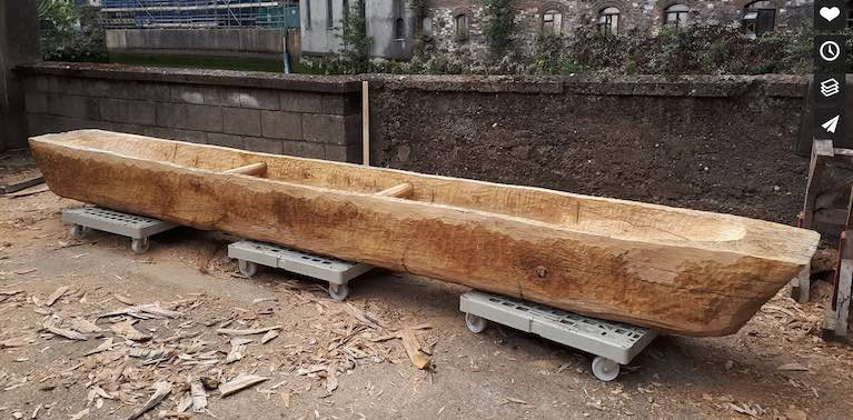
An oak tree’s transformation from trunk to replica iron age boat on Connemara's Lough Corrib has been filmed as part of a University College Cork (UCC) project.

Entitled "A New Logboat for Lough Corrib: The Pallasboy Project", the film was made over 20 months and documents how the logboat was modelled on a 2,400-year-old vessel found at the bottom of Lough Corrib.

The original was partially excavated and recorded by Karl Brady of Ireland's National Monuments Service's Underwater Archaeology Unit.

Photographer and former archaeologist Brian Mac Domhnaill’s film begins with the felling of an oak in the Vale of Clara, Glenalough, Co Wicklow in November 2017.

It closes with the boat’s maiden voyage at Knockferry, Lough Corrib in Galway in July 2019. The boat launch was hosted in partnership with Moycullen and Oughterard Heritage, and drew national media attention. 

UCC archaeologist Dr Benjamin Gearey noted that the film documents the painstaking process of converting around two tonnes of oak tree into a close replica of a 2000 year vessel, and its joyous maiden voyage onto the waters beneath which the original still lies". 

As Afloat reported last July, the replica was modelled on the sunken boat that measures some 7.5m long, 0.61m wide and 0.4m deep.

It was created by Mark Griffiths, as part of the Pallasboy Project, an international collaborative study established at UCC to investigate the crafting of prehistoric wooden objects and involving archaeologists, woodworkers and artists.

After the log was felled and the trunk prepared, Griffiths carved the replica over a period of 18 days at the Meitheal Mara community boatyard in Cork City, using a combination of replica prehistoric and modern tools.

The project was funded by the World Wood Day Fund via the International Wood Culture Society. The replica log boat has since been gifted to Moycullen Heritage Society.
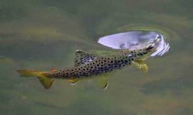
Published in Historic Boats
Tagged under

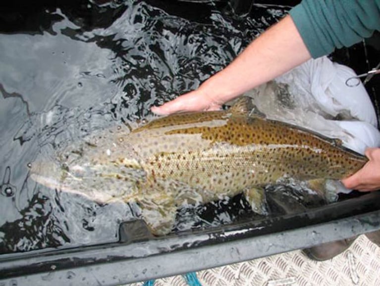
A newly published research paper co-authored by experts in Ireland highlights the importance of ferox trout to the fisheries of Lough Corrib and Lough Mask.

Ferox trout are highly prized by trophy anglers, and Loughs Corrib and Mask have recorded the majority of Irish specimens since angling records began in the 1950s.

The large, long-lived, fish-eating trout are normally found in deep lakes and are believed to be genetically distinct from normal brown trout, having evolved after the last Ice Age 12,000 years ago.

Little was known about the spawning location of Irish ferox trout compared to normal brown trout, and a radio tracking study was initiated in both catchments in 2005.

Local anglers and Inland Fisheries Ireland (IFI) staff helped catch large ferox trout on both lakes in order to insert radio tags.

The fish were released after tagging and then tracked with help from the Irish Air Corps helicopter unit and by walking spawning streams with a radio tracking antenna to determine in which streams ferox spawned.

Scientists from Inland Fisheries Ireland worked with colleagues at the Norwegian Institute for Nature Research on the data collected in this study.

Results from radio tracking showed that the majority (92%) of ferox trout tagged in Lough Corrib spawned in a single spawning stream, the Cong River, while the majority (76%) of ferox trout tagged in Lough Mask spawned in the Cong canal and Cong River.

These results, as published in the Journal of Fish Biology, indicate that these streams are most likely the principle spawning locations of ferox trout in both lakes.

Dr Paddy Gargan, senior research officer at Inland Fisheries Ireland and lead author on the publication, said: “The occurrence of ferox trout predominantly in single spawning rivers in both catchments highlights the vulnerability of the ferox populations with estimates of their population size thought to be small”.

IFI’s head of research Dr Cathal Gallagher welcomed the findings and said: “It was important that conservation measures, based on this research, have been introduced in the Corrib and Mask catchments continue to protect ferox trout.

“These conservation measures have reduced the number of ferox trout being killed and claimed as specimens and support the conservation of this unique trout.”

Published in Angling

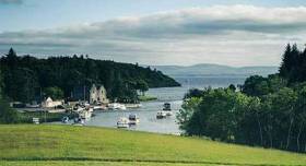
Life was simpler back in 1882 when the sailing folk of Galway Bay and the stunningly beautiful Lough Corrib inaugurated the Galway to Cong race the length of the great lake writes W M Nixon. People didn’t have cars, and still less had they efficient road trailers. So if you raced the whole way from Galway up the lake to Cong, you then had to expect to sail back again, and you’d have covered at least 60 miles by the time the day was out, though it’s likely they made at least two days of it.

But now with modern road trailers and dinghies dominant, complex logistics enter the equation. Since its revival in 1972, the race has been just one way – southwards from Cong to Corrib Village in Galway city. In order to ensure a smooth state of affairs after the finish, competitors are offered the option of leaving their boats by road at Lisloughry beforehand, then leaving their cars and trailers at Corrib Village where a bus will be on hand early in the Saturday morning to get them back to their waiting boats in Cong.

lough corrib2
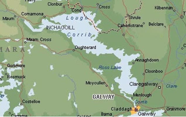
The basic shape of Lough Corrib indicated in this plan gives some idea of the length of Saturday’s race, but doesn’t fully reveal the lake’s island-studded nature (below) Photo: W M Nixon
lough corrib3
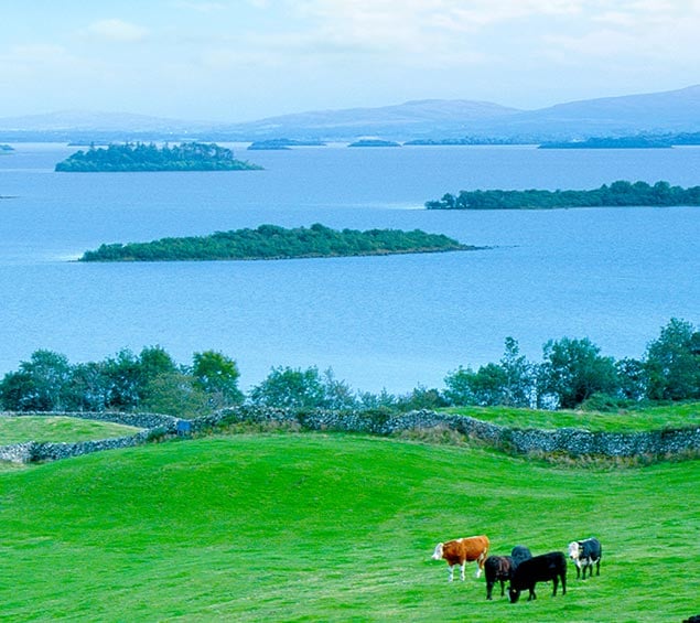
Not only is the race now a convenient half size in length (though still all of 30 miles), but there’s a pit stop for lunch and conviviality at Kilbeg, more or less halfway down the lake where the expansive Corrib is at its narrowest, and there’s a pub nearby. But the very fact that your car and trailer are waiting at the south end of the lake is a real spur to completing the event

On the other hand, with people making last-minute decisions based on the fickle weather of 2019, maybe the handiest contact is direct to organiser John Barry, Rear Commodore (Dinghies) Galway Bay SC, at 086-8111269 – he reports that entries already in range from 420s to a selection of RS dinghies, participant ages are from 15 to 85, and there’s a strong female contingent taking on the challenge.

Meanwhile, the GBSC cruisers are recovering from their Summer Solstice Cruise to the Aran Islands at the weekend, which had a dozen boats taking part. While the sail round Inishmore on Saturday enjoyed Mediterranean conditions, Sunday brought driving easterly rain and a very damp beat home - all very character-building stuff.

Published in Galway Harbour
Tagged under

Two anglers recently appeared in court on charges relating to illegal fishing methods on the Cong River and fishing during the closed season.

On Thursday 23 May, Mindaugas Jenkus of Claremorris, Co Mayo and Dalius Bureninas of Birr, Co Offaly appeared in front of Judge Mary Fahy at Clifden District Court in respect of breaches of fisheries legislation on the Cong River which occurred on 9 September 2018.

Both defendants represented themselves and pleaded guilty to strokehauling (using a weighted instrument or device with a rod and line or otherwise to foul-hook fish) and fishing out of season on the Cong River.

Bureninas also pleaded guilty to a further charge of obstruction under Section 301 (7) of the Fisheries (Consolidation) Act 1959.

Fisheries officer Paul Reynolds outlined the facts of the case to the court, while assistant fisheries inspector Barry Kelly also told the court that the Cong River was a very important salmonid fishery with has a large run of Atlantic salmon and a good stock of brown trout.

It is also of particular conservation interest in relation to ferox trout, for which the river is renowned.

The Cong River is one of the main tributaries of Lough Corrib, and is one of the most important salmon rivers in the west of Ireland

Fisheries inspector Pat Gorman stated that these offences were very serious due to the conservation status of the Cong River, when asked his opinion by Judge Fahy.

The judge commented on how serious a matter these offences were and referred to Bureninas giving a false name and address when lawfully demanded. She also noted that Mr Jenkus had a recent conviction for a similar fisheries offence.

Judge Fahy stated that if both defendants paid costs of €600 each to the court at a sitting of Clifden District Court on 26 September, she may deal with the matter by way of a somewhat reduced fine.

She also warned both men to be on their best behaviour and not to come to the attention of Inland Fisheries Ireland (IFI) again as there was a risk of a custodial sentence being imposed.

“The Cong River is one of the main tributaries of Lough Corrib, is one of the most important salmon rivers in the west of Ireland and provides habitat for a very unique salmonid sub-species, ferox trout,” said IFI chief executive Dr Ciaran Byrne when commenting on the case.

“The Cong River is closed to angling during September as a conservation measure relating to both Atlantic salmon and ferox trout. The river attracts many anglers and tourists annually to fish for these unique wild salmonid species.”

Published in Angling

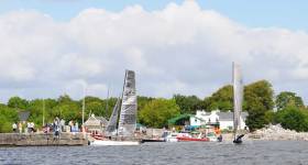
Sailors and boating enthusiasts from Galway’s sailing and boating clubs are coming together next month to follow their forebears in Europe’s oldest and longest inland sailing race.

On Saturday 29 June the fleet of dinghies will pit their wits against the elements and each other on the historic route along the length of Lough Corrib from Lisloughrey near Cong to Galway city.

Since 1882, sailors have raced the length of Lough Corrib. While the origin of the wager which prompted the first races is shrouded in myth and lore, the early races were hotly contested and a great social occasion.

They were very much a test of stamina as well as skill, with competitors completing a round trip of over 60 nautical miles from Galway to Ashford Castle and back again. It was raced annually until 1914 and the outbreak of World War I.

The race was revived in its current format, sailed in one direction from Lisloughrey to Galway, in 1972 and again became a stable in the Galway maritime calendar.

However, the weather gods have not been good to the race in recent years.

So, to ensure a successful event this year, the boating and sailing clubs around Galway have come together and moved the event to an earlier slot in the calendar.

It will take place this year on 29 June and follow the traditional steamer channel through the lake.

Full details of the race and the online registration are available on the Galway Bay Sailing Club website.

Transport will leave Corrib Rowing and Yacht Club and the Galway Commercial Boat Club at 8am to bring sailors to the start line in Lisloughrey. From there, the boats will make their way to Kilbeg for lunch and then continue on to the finish line in the lower Corrib.

However, the challenges don’t end there, with the Quincentennial Bridge providing a final obstacle to be negotiated — usually with the mast, sails and sailors in the water!

Following the race, there will be the chance to relive the decisive moments of the race at a reception hosted by the Commercial club after the historical silverware has been presented at CRYC.

Galway Bay Sailing Club has a link to the Notice of Race and Sailing Instructions, as well as the online registration form. For more details about the 2019 Cong-Galway Sailing Race, see the Facebook event page HERE.

Published in Racing

The owner of an angling centre from Moycullen was convicted at Galway District Court last Tuesday 5 February for the illegal use of a net and for possession of an unlawfully captured trout.

The court heard that Michael Canney, with an address at Portarra Lodge, was approached by Inland Fisheries Ireland (IFI) fisheries officers on the morning of 25 June 2018 as he was hauling an illegal net into a lake boat on Lough Corrib.

Diorai Ford, solicitor acting for IFI, outlined to the court that fisheries officers had covertly kept the illegal net under surveillance throughout the night.

The net had been fishing since the previous evening when it was discovered during a routine fisheries patrol.

Canney was accompanied in the boat by a foreign student who was staying with him where he operates an angling centre.

When Canney retrieved the net into the boat, it contained one dead brown trout. While in the act of lifting the net, Canney was approached by a fisheries officer on a personal water craft.

Canney was co-operative throughout. The equipment used in the commission of the offences was seized and included a lake boat and engine.

Solicitor for the defendant, Sinead Fitzpatrick, stated in his defence that Canney had a group of Italian anglers staying with him at the time and he was undertaking a survey to see what fish stocks were in the area.

Judge Mary Fahy commented that she knew several people who fish legally on a regular basis on Lough Corrib and that Canney was a mature man and that he knew that what he was doing was illegal.

Judge Fahy convicted Mr Canney on both counts, and imposed a fine of €500 for the use of an unlawful net, along with a fine of €500 for the possession of an unlawfully captured trout.

Costs of €600 were awarded to IFI’s solicitor. The boat and engine that Canney used in the commission of the offences were also forfeited.

IFI chief executive Dr Ciaran Byrne said: “Lough Corrib is considered Ireland’s finest wild brown trout fishery and is also a Special Area of Conservation (SAC) designated for the protection of numerous aquatic species including Atlantic salmon.

“Lough Corrib attracts a vast number of anglers from all over the world who enjoy the unique angling for wild brown trout, Atlantic salmon, pike and coarse fish that the lake offers.

“This conviction reflects the long hours that dedicated fisheries officers spend on a daily basis in protecting our valuable fisheries resource.”

Published in Angling

#Angling - Inland Fisheries Ireland (IFI) has confirmed a fish kill on the River Tolka that was reported earlier this week.

Fisheries investigators found dead fish over a 5km stretch of the river in the Tolka Valley Park area, following the report on Tuesday 18 September.

According to IFI, a “significant source of polluting material has been identified” and samples were taken for analysis.

In the meantime “relevant parties are undertaking appropriate remedial action” as the investigation continues.

Also this week, Minister of State for inland fisheries Seán Kyne committed €300,000 for the removal of an invasive waterweed in Lough Corrib.

IFI will begin operations in 2019 to remove the aquatic plant Lagarosiphon major from the lough, after successful cutting and picking operations over the summer months this year.

In addition to these management operations, IFI commenced a research project last month which aims to establish the current distribution of L major in Lough Corrib.

New innovative methods are being trialled to survey the aquatic plant as part of this research. These include unmanned aerial drones, sub-aquatic remotely operated vehicles (ROVs) and modern remote sensing techniques.

Speaking as he visited IFI’s stand at the National Ploughing Championships, Minister Kyne also asked the fisheries body and his department to continue liaison with the National Parks and Wildlife Service (NPWS), who have responsibility for the legislation covering Alien Invasive Species (AIS).

Published in Angling
Page 1 of 3

General Information on using Waterways Ireland inland navigations

Safety on the Water

All users of the navigations are strongly recommended to make themselves aware of safety on the water for whatever activity they are involved in and to read the advice offered by the various governing bodies and by:

The Dept. of Transport, Ireland: www.gov.ie/transport and The Maritime and Coastguard Agency, UK, The RNLI – Water Safety Ireland for information in terms of drowning prevention and water safety.

Registration of Vessels

All vessels using the Shannon Navigation, which includes the Shannon-Erne Waterways and the Erne System must be registered with Waterways Ireland. Only open undecked boats with an engine of 15 horsepower or less on the Shannon Navigation, and vessels of 10 horsepower or less on the Erne System, are exempt. Registration is free of charge.

Craft registration should be completed online at: https://www.waterwaysireland.org/online-services/craft-registration

Permits for use of the Grand and Royal Canals and the Barrow Navigation

All vessels using the Grand and Royal Canals and the Barrow Navigation must display appropriate valid Permit(s) i.e A Combined Mooring and Passage Permit (€126) and if not intending to move every five days, an Extended Mooring Permit (€152).

Permit applications should be completed online at: https://www.waterwaysireland.org/online-services/canal-permits

Passage on the Royal and Grand Canals – Dublin Area

For boat passage through the locks east of Lock 12 into / out of Dublin on either the Royal or Grand Canals, Masters are requested to contact the Waterways Ireland Eastern Regional Office (M-F 9.30am-4.30pm) on tel: +353(0)1 868 0148 or email [email protected] prior to making passage in order to plan the necessary lock-keeping assistance arrangements.

On the Grand Canal a minimum of two days notice prior to the planned passage should be given, masters should note that with the exception of pre-arranged events, a maximum of 2 boats per day will be taken through the locks, travelling either east or west.

Movements in or out of the city will be organised by prior arrangement to take place as a single movement in one day. Boaters will be facilitated to travel the system if their passage is considered to be safe by Waterways Ireland and they have the valid permit(s) for mooring and passage.

Newcomen Lifting Bridge

On the Royal Canal two weeks’ notice of bridge passage (Newcomen Lifting Bridge) is required for the pre-set lift date, and lock assistance will then also be arranged. A minimum of 2 boats is required for a bridge lift to go ahead.

Waterways Ireland Eastern Regional Office (Tel: +353(0)1 868 0148 or [email protected] ) is the point of contact for the bridge lift.

A maximum number of boats passing will be implemented to keep to the times given above for the planned lifts (16 for the Sat / Sun lifts & 8 for the weekday lifts). Priority will be given on a first come first served basis.

On day of lift, boaters and passengers must follow guidance from Waterways Ireland staff about sequence of passage under bridge & through Lock 1, and must remain within signed and designated areas.

Events Held on the Waterways

All organised events taking place on the waterways must have the prior approval of Waterways Ireland. This is a twelve week process and application forms must be accompanied with the appropriate insurance, signed indemnity and risk assessment. The application should be completed on the Waterways Ireland events page at :

https://www.waterwaysireland.org/online-services/event-approval

Time Limits on Mooring in Public Harbours

On the Shannon Navigation and the Shannon-Erne Waterway craft may berth in public harbours for five consecutive days or a total of seven days in any one month.

On the Erne System, revised Bye Laws state that: No master or owner shall permit a vessel, boat or any floating or sunken object to remain moored at or in the vicinity of any public mooring, including mooring at any other public mooring within 3 kilometres of that location, for more than 3 consecutive days and shall not moor at that same mooring or any other public mooring within 3 kilometres of that location within the following 3 consecutive days without prior permission by an authorised official.

Winter Mooring on the Shannon Navigation and Shannon Erne Waterway

Winter mooring may be availed of by owners during the period 1 Nov to 31 Mar by prior arrangement and payment of a charge of €63.50 per craft. Craft not availing of Winter Mooring must continue to comply with the “5 Day Rule”. Winter Mooring applications should be completed online at : https://www.waterwaysireland.org/online-services/winter-moorings-booking

Owners should be aware that electricity supply and water supply to public moorings is disconnected for the winter months. This is to protect against frost damage, to reduce running costs and to minimise maintenance requirements during the winter months.

Vessel owners are advised that advance purchasing of electricity on the power bollards leading up to the disconnection date should be minimal. Electricity credit existing on the bollards will not be recoverable after the winter decommissioning date. Both services will be reinstated prior to the commencement of the next boating season.

Smart Cards

Waterways Ireland smart cards are used to operate locks on the Shannon Erne Waterway, to access the service blocks, to use the pump-outs along the navigations, to avail of electrical power at Waterways Ireland jetties.

Berthing in Public Harbours

Masters are reminded of the following:

  • Equip their vessel with mooring lines of appropriate length and strength and only secure their craft to mooring bollards and cleats provided for this purpose.
  • Ensure the available berth is suitable to the length of your vessel, do not overhang the mooring especially on finger moorings on floating pontoon moorings.
  • Ensure mooring lines, electric cables and fresh water hoses do not create a trip hazard on public jetties for others users.
  • Carry sufficient fenders to prevent damage to your own vessel, other vessels and WI property.
  • Allow sufficient space between your vessel and the vessel ahead /astern (c.1m) for fire safety purposes and /or to recover somebody from the water.
  • Do not berth more than two vessels side by side and ensure there is safe access/egress at all times between vessels and onto the harbour itself.
  • Do not berth in such a way to prevent use of harbour safety ladders, slipways or pump-outs.
  • Do not allow the bow of your vessel to overhang the walkway of a floating mooring thus creating a hazard for others with an overhanging anchor or bow fendering.
  • Animals are not allowed to be loose or stray at any time.
  • Harbour and jetty infrastructure such as railings, power pedestals, fresh water taps, electric light poles, safety bollards, ladders etc are not designed for the purpose of mooring craft , they will not bear the strain of a vessel and will be damaged.
  • At Carrybridge on the Erne System, Masters of vessels are not permitted to use stern on mooring. Masters of vessels must use the mooring fingers for mooring of vessels and for embarkation / disembarkation from vessels.

Passenger Vessel Berths

Masters of vessels should not berth on passenger vessel berths where it is indicated that an arrival is imminent. Passenger vessels plying the navigations generally only occupy the berths to embark and disembark passengers and rarely remain on the berths for extended periods or overnight.

Lock Lead-in Jetties

Lead-in jetties adjacent to the upstream and downstream gates at lock chambers are solely for the purpose of craft waiting to use the lock and should not be used for long term berthing.

Vessel Wake

Vessel wake, that is, the wave generated by the passage of the boat through the water, can sometimes be large, powerful and destructive depending on the hull shape and engine power of the vessel. This wake can be detrimental to other users of the navigation when it strikes their craft or inundates the shoreline or riverbank. Masters are requested to frequently look behind and check the effect of their wake / wash particularly when passing moored vessels, on entering harbours and approaching jetties and to be aware of people pursuing other activities such as fishing on the riverbank.

Speed Restriction

A vessel or boat shall not be navigated on the Shannon Navigation at a speed in excess of 5 kph when within 200 metres of a bridge, quay, jetty or wharf, when in a harbour or canal or when passing within 100 metres of a moored vessel or boat.

Vessels navigating the Shannon-Erne Waterway should observe the general 5 kph speed limit which applies along the waterway. This is necessary in order to prevent damage to the banks caused by excessive wash from vessels.

Vessels navigating the Erne System should observe the statutory 5kt / 6mph / 10kph speed limit areas.

A craft on the Royal and Grand canals shall not be navigated at a speed in excess of 6km per hour.

A craft on the Barrow Navigation shall not be navigated at a speed in excess of 11km per hour except as necessary for safe navigation in conditions of fast flow.

Bank Erosion

Narrow sections of all the navigations are particularly prone to bank erosion due to the large wash generated by some craft. Masters are requested to be vigilant and to slow down to a speed sufficient to maintain steerage when they observe the wash of their craft inundating the river banks.

Unusual Waterborne Activity

Unusual waterborne vessels may be encountered from time to time, such as, hovercraft or amphibious aircraft / seaplanes. Masters of such craft are reminded to apply the normal “Rule of the Road” when they meet conventional craft on the water and to allow extra room to manoeuvre in the interest of safety.

Sailing Activity

Mariners will encounter large numbers of sailing dinghies from late June to August in the vicinity of Lough Derg, Lough Ree and Lower Lough Erne. Sailing courses are marked by yellow buoys to suit weather conditions on the day. Vessels should proceed at slow speed and with due caution and observe the rules of navigation when passing these fleets, as many of the participants are junior sailors under training.

Rowing

Mariners should expect to meet canoes and vessels under oars on any part of the navigations, but more so in the vicinity of Athlone, Carrick-on-Shannon, Coleraine, Enniskillen and Limerick. Masters are reminded to proceed at slow speed and especially to reduce their wash to a minimum when passing these craft as they can be easily upset and swamped due to their very low freeboard and always be prepared to give way in any given traffic situation.

Canoeing

Canoeing is an adventure sport and participants are strongly recommended to seek the advice of the sport’s governing bodies i.e Canoeing Ireland and the Canoe Association of Northern Ireland, before venturing onto the navigations.

Persons in charge of canoes are reminded of the inherent danger to these craft associated with operating close to weirs, sluice gates, locks and other infrastructure particularly when rivers are in flood and large volumes of water are moving through the navigations due to general flood conditions or very heavy localised precipitation e.g. turbulent and broken water, stopper waves. Shooting weirs is prohibited without prior permission of Waterways Ireland.

Canoeists should check with lockkeepers prior entering a lock to ensure passage is done in a safe manner. Portage is required at all unmanned locks.

Canoe Trail Network – "Blueways"

Masters of powered craft are reminded that a canoe trail network is being developed across all navigations and to expect more organised canoeing along these trails necessitating slow speed and minimum wash when encountering canoeists, rowing boats etc

Rockingham and Drummans Island Canals – Lough Key

It is expected that work on Rockingham and Drummans Island Canals on Lough Key will be completed in 2021. Access to these canals will be for non-powered craft only, eg canoes, kayaks, rowing boats.

Fast Powerboats and Personal Watercraft (Jet Skis)

Masters of Fast Powerboats (speed greater than 17kts) and Personal Watercraft (i.e.Jet Skis) are reminded of the inherent dangers associated with high speed on the water and especially in the confines of small bays and narrow sections of the navigations. Keeping a proper look-out, making early alterations to course and /or reducing speed will avoid conflict with slower vessels using the navigation. Personal Watercraft are not permitted to be used on the canals.

Towing Waterskiers, Wakeboarders, Doughnuts etc

Masters of vessels engaged in any of these activities are reminded of the manoeuvring constraints imposed upon their vessel by the tow and of the added responsibilities that they have to the person(s) being towed. These activities should be conducted in areas which are clear of conflicting traffic. It is highly recommended that a person additional to the master be carried to act as a “look-out” to keep the tow under observation at all times.

Prohibition on Swimming

Swimming in the navigable channel, particularly at bridges, is dangerous and is prohibited due to the risk of being run over by a vessel underway in the navigation.

Age Restrictions on operating of powered craft

In the Republic of Ireland, Statutory Instrument 921 of 2005 provides the legal requirements regarding the minimum age for operating of powered craft. The Statutory Instrument contains the following requirements:

- The master or owner of a personal watercraft or a fast power craft shall take all reasonable steps to ensure that a person who has not attained the age of 16 years does not operate or control the craft

- The master or owner of a pleasure craft powered by an engine with a rating of more than 5 horse power or 3.7 kilowatts shall take all reasonable steps to ensure that a person who has not attained the age of 12 years does not operate or control the craft.

Lifejackets and Personal Flotation Devices (PFDs)

Lifejackets and PFD’s are the single most important items of personal protective equipment to be used on a vessel and should be worn especially when the vessel is being manoeuvred such as entering / departing a lock, anchoring, coming alongside or departing a jetty or quayside.

In the Republic of Ireland, Statutory Instrument 921 of 2005 provides the legal requirements regarding the wearing of Personal Flotation Devices. The Statutory Instrument contains the following requirements:

- The master or owner of a pleasure craft (other than a personal watercraft) shall ensure, that there are, at all times on board the craft, sufficient suitable personal flotation devices for each person on board.

- A person on a pleasure craft (other than a personal watercraft) of less than 7 metres length overall shall wear a suitable personal flotation device while on board an open craft or while on the deck of decked craft, other than when the craft is made fast to the shore or at anchor.

- The master or owner of a pleasure craft (other than a personal watercraft) shall take all reasonable steps to ensure that a person who has not attained the age of 16 years complies with paragraph above.

- The master or owner of a pleasure craft (other than a personal watercraft), shall take all reasonable steps to ensure that a person who has not attained the age of 16 years wears a suitable personal flotation device while on board an open craft or while on the deck of a decked craft other than when it is made fast to the shore or at anchor.

- The master or owner of a pleasure craft (other than a personal watercraft) shall take all reasonable steps to ensure that a person wears a suitable personal flotation device, at all times while – (a) being towed by the craft, (b) on board a vessel or object of any kind which is being towed by the craft.

Further information is available at: http://www.irishstatutebook.ie/eli/2005/si/921/made/en/print

Firing Range Danger Area – Lough Ree

The attention of mariners is drawn to the Irish Defence Forces Firing Range situated in the vicinity of buoys No’s 2 and 3, on Lough Ree on the Shannon Navigation. This range is used regularly for live firing exercises, throughout the year, all boats and vessels should stay clear of the area marked with yellow buoys showing a yellow "X" topmark and displaying the word "Danger".

Shannon Navigation, Portumna Swing Bridge Tolls

No attempt should be made by Masters’ of vessels to pay the bridge toll while making way through the bridge opening. Payment will only be taken by the Collector from Masters when they are secured alongside the jetties north and south of the bridge.

Navigating from Killaloe to Limerick on the Shannon Navigation

The navigation from Killaloe to Limerick involves passage through Ardnacrusha locks, the associated headrace and tailrace and the Abbey River into Limerick City. Careful passage planning is required to undertake this voyage. Considerations include: lock passage at Ardnacrusha, water flow in the navigation, airdraft under bridges on Abbey River in Limerick, state of tide in Limerick

Users are advised to contact the ESB Ardnacrusha hydroelectric power station (00353 (0)87 9970131) 48 hours in advance of commencing their journey to book passage through the locks at Ardnacrusha. It is NOT advised to undertake a voyage if more than one turbine is operating (20MW), due to the increased velocity of flow in the navigation channel, which can be dangerous. To ascertain automatically in real time how many turbines are running, users can phone +353 (0)87 6477229.

For safety reasons the ESB has advised that only powered craft with a capacity in excess of 5 knots are allowed to enter Ardnacrusha Headrace and Tailrace Canals.

Passage through Sarsfield Lock should be booked on +353-87-7972998, on the day prior to travel and it should be noted also that transit is not possible two hours either side of low water.

A Hydrographic survey in 2020 of the navigation channel revealed that the approach from Shannon Bridge to Sarsfield Lock and the Dock area has silted up. Masters of vessels and water users are advised to navigate to the Lock from Shannon bridge on a rising tide one or two hours before High Tide.

Lower Bann Navigation

The attention of all users is drawn to the “Users Code for the Lower Bann”, in particular to that section covering “Flow in the River” outlining the dangers for users both on the banks and in the navigation, associated with high flow rates when the river is in spate. Canoeists should consult and carry a copy of the “Lower Bann Canoe Trail” guide issued by the Canoe Association of Northern Ireland. Users should also contact the DfI Rivers Coleraine, who is responsible for regulating the flow rates on the river, for advisory information on the flow rates to be expected on any given day.

DfI Rivers Coleraine. Tel: 0044 28 7034 2357 Email: [email protected]

Lower Bann Navigation – Newferry – No wake zone

A No Wake Zone exists on the Lower Bann Navigation at Newferry. Masters of vessels are requested to proceed at a slow speed and create no wake while passing the jetties and slipways at Newferry.

Overhead Power Lines (OHPL) and Air draft

All Masters must be aware of the dangers associated with overhead power lines, in particular sailing vessels and workboats with cranes or large air drafts. Voyage planning is a necessity in order to identify the location of overhead lines crossing the navigation.

Overhead power line heights on the River Shannon are maintained at 12.6metres (40 feet) from Normal Summer level for that section of navigation, masters of vessels with a large air draft should proceed with caution and make additional allowances when water levels are high.

If a vessel or its equipment comes into contact with an OHPL the operator should NOT attempt to move the vessel or equipment. The conductor may still be alive or re-energise automatically. Maintain a safe distance and prevent third parties from approaching due to risk of arcing. Contact the emergency services for assistance.

Anglers are also reminded that a minimum ground distance of 30 metres should be maintained from overhead power lines when using a rod and line.

Submarine Cables and Pipes

Masters of vessels are reminded not to anchor their vessels in the vicinity of submarine cables or pipes in case they foul their anchor or damage the cables or pipes. Look to the river banks for signage indicating their presence.

Water Levels - Precautions

Low Water Levels:

When water levels fall below normal summer levels masters should be aware of:

Navigation

To reduce the risk of grounding masters should navigate on or near the centreline of the channel, avoid short cutting in dog-legged channels and navigating too close to navigation markers.

Proceeding at a slow speed will also reduce “squat” effect i.e. where the vessel tends to sit lower in the water as a consequence of higher speed.

Slipways

Reduced slipway length available under the water surface and the possibility of launching trailers dropping off the end of the concrete apron.

More slipway surface susceptible to weed growth requiring care while engaged in launching boats, from slipping and sliding on the slope. Note also that launching vehicles may not be able to get sufficient traction on the slipway once the craft is launched to get up the incline.

Bank Erosion

Very dry riverbanks are more susceptible to erosion from vessel wash.

Lock Share

Maximising on the number of vessels in a lock will ensure that the total volume of water moving downstream is decreased. Lock cycles should be used for vessels travelling each way.

High Water Levels:

When water levels rise above normal summer level masters should be aware of:

Navigation

Navigation marks will have reduced height above the water level or may disappear underwater altogether making the navigable channel difficult to discern.

In narrow sections of the navigations water levels will tend to rise more quickly than in main streams and air draft at bridges will likewise be reduced.

There will also be increased flow rates particularly in the vicinity of navigation infrastructure such as bridges, weirs, locks etc where extra care in manoeuvring vessels will be required.

Harbours and Jetties

Due care is required in harbours and at slipways when levels are at or near the same level as the harbour walkways' as the edge will be difficult to discern especially in reduced light conditions. It is advised that Personal Flotation Devices be worn if tending to craft in a harbour in these conditions.

Slipways

Slipways should only be used for the purpose of launching and recovering of water craft or other objects from the water. Before using a slipway it should be examined to ensure that the surface has sufficient traction/grip for the intended purpose such as launching a craft from a trailer using a vehicle, that there is sufficient depth of water on the slipway to float the craft off the trailer before the concrete apron ends and that the wheels of the trailer do not drop off the edge of the slipway. That life-saving appliances are available in the vicinity, that the vehicle is roadworthy and capable of coping with the weight of the trailer and boat on the incline. It is recommended that slipway operations are conducted by two persons.

Caution to be Used in Reliance upon Aids to Navigation

The aids to navigation depicted on the navigation guides comprise a system of fixed and floating aids to navigation. Prudent mariners will not rely solely on any single aid to navigation, particularly a floating aid to navigation. With respect to buoys, the buoy symbol is used to indicate the approximate position of the buoy body and the ground tackle which secures it to the lake or river bed. The approximate position is used because of the practical limitations in positioning and maintaining buoys in precise geographical locations. These limitations include, but are not limited to, prevailing atmospheric and lake/river conditions, the slope of and the material making up the lake/river bed, the fact that the buoys are moored to varying lengths of chain, and the fact that the buoy body and/or ground tackle positions are not under continuous surveillance. Due to the forces of nature, the position of the buoy body can be expected to shift inside and outside the charted symbol.

Buoys and perches are also moved out of position or pulled over by those mariners who use them to moor up to instead of anchoring. To this end, mariners should always monitor their passage by relating buoy/perch positions with the published navigation guide. Furthermore, a vessel attempting to pass close by always risks collision with a yawing buoy or with the obstruction that the buoy or beacon/perch marks.

Masters of Vessels are requested to use the most up to date Navigation guides when navigating on the Inland Waterways.

Information taken from Special Marine Notice No 1 of 2023