


Displaying items by tag: Marine Institute
Sixty–Foot Record Wave Recorded During Hurricane Ophelia
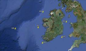
Record wave heights were captured by the Irish Weather Buoy Network during Hurricane Ophelia on Monday 16th October, causing one of the five weather buoys to break it moorings.
The highest wave was recorded off the Irish coastline at 16.00 on Monday when the M5 weather buoy off the South East coast, measured a record individual wave (Hmax) of 17.81m* and a record significant wave height (Hs) of 12.97m **.
The M5 weather buoy subsequently broke away from its mooring and the Marine Institute coordinated the retrieval process as a matter of urgency. The M5 was recovered yesterday by the MV Puffin of Fastnet Shipping (Waterford) and brought ashore last night.
As Ophelia moved northwards, the M2 buoy to the east of Dublin also experienced a record significant wave height (HS )** of 6.64m measured at 18.00 on Monday 16th.
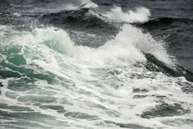
![]() Waves lash the Baltimore beacon in West Cork during Storm Ophelia. Photo: Youen Jacob
Waves lash the Baltimore beacon in West Cork during Storm Ophelia. Photo: Youen Jacob
Earlier in the day, at 12.00, the M3 buoy, off the South West coast measured an individual wave height of 13.59m, although this was not a record wave for this buoy.
In addition to measuring the waves, the weather buoy network, which is managed by the Marine Institute provides further vital atmospheric (including wind speed) and oceanographic information to support both maritime safety and, importantly in storm events such as Ophelia, help to validate the weather forecast models run by Met Éireann providing guidance to the national emergency planning efforts.
The Irish Weather Buoy Network is designed to improve weather forecasts and safety at sea around Ireland. The buoy network also provides operational ocean models, shipping bulletins, gale and swell warnings as well as data for general public information and research. The network is managed by the Marine Institute in collaboration with Met Éireann, the UK Met Office and the Irish Department of Transport, Tourism and Sport (DTTAS). Real time data from the network can be found here.
Canada’s Environment & Climate Change Minister Visits Marine Institute To Talk Atlantic Ocean Collaboration
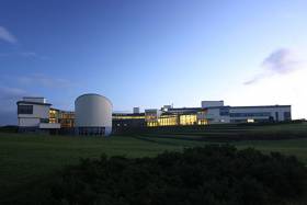
#MarineScience - Canada’s Minister of Environment and Climate Change, Catherine McKenna, was at the Marine Institute headquarters in Oranmore yesterday (Friday 13 October) to discuss collaborations under the Atlantic Ocean Research Alliance.
The Marine Institute meetings were part of a tour by Minister McKenna to London and Dublin to advance discussions on clean growth and climate action.
Minister McKenna was accompanied by Canadian Ambassador to Ireland Kevin Vickers and met with the Marine Institute’s chair Dr John Killen and chief executive Dr Peter Heffernan, members of the senior management team and scientific staff.
The meeting provided an opportunity to discuss existing projects and opportunities to further Ireland and Canada’s collaboration on Atlantic Ocean research and climate impacts.
“Transatlantic cooperation is essential to broadening our scientific understanding of the Atlantic Ocean and helping to ensure it remains healthy and productive,” said Dr Heffernan. “It’s hugely important for Ireland and brings us closer to achieving the goals of the Galway Statement on Atlantic Ocean Co-operation signed here at the Marine Institute Galway in May 2013 by the EU, USA and Canada.
“The goal is to work together, share expertise and advance our science goals to promote the sustainable management of our Atlantic ocean for the benefit of all.”
Since the signing of the Galway Statement, the Marine Institute says it has led initiatives to further this collaboration in areas including Atlantic seabed mapping and climate change research, and is leading the EU H2020-funded Atlantic Ocean Research Alliance - Coordination and Support Action.
Speaking on her visit to the Marine Institute, Minister McKenna said: “Canada and Ireland are natural partners on marine research. Canada recognises that Atlantic research will be more effective if we work together and on both sides of the ocean.
“The knowledge we gain benefits us all, and all and is crucial to helping us to meet the challenges we face, in particular climate change, food security and new sources of energy.”
Ambassador Vickers added: “We are now entering a new era of transatlantic co-operation that will enable us to achieve great things together in the coming years.
“We are raising the importance for ocean discovery above sectoral interests and putting marine research on a new global level that transcends national borders, making literal the bonds connecting Ireland and Canada, to increase our knowledge of the ocean that joins us and to maximise the innovation potential it affords us.”
Commitments To €6M Funding For Seabed Mapping & Marine Research Welcomed
#MarineScience - The Marine Institute has welcomed commitments of €6 million in funding for seabed mapping and marine research announced at the fourth Our Ocean Conference in Malta last week.
Ciaran Cannon, Minister of State for International Development, addressed representatives from more than 200 countries at the EU conference, stressing the importance of promoting and protecting the world's marine resources for present and future generations.
Aside from the new funding for mapping and research, Minister Cannon also announced the roll-out of a 'groundbreaking' Global Citizenship marine environment education module for school children from September 2017 onwards.
“This programme will increase ocean literacy by fostering understanding of the important role our oceans play in our lives, how individual actions can affect them and how we can act together to protect them,” he said.
Marine Institute chief executive Dr Peter Heffernan explained that the new module supports the aims of the institute’s own Explorers Education Programme “to build on Ireland's marine and maritime heritage by increasing awareness of the value, opportunities and social benefits of our ocean wealth and identity.”
Meanwhile, Minister Cannon committed to €320,000 in funding to the 2017 Clean Coasts programme and its more than 550 volunteer groups established in Ireland to date.
Also noted was an expansion of the 2015 Fishing for Litter programme, and continued contributions to support developing countries engagement at the UN on issues relating to marine governance.
In addition, Minister Cannon reaffirmed Ireland's commitment to prohibit the sale or manufacture of certain products containing microbeads, announced at the UN in June of this year.
Marine Minister Introduces Conservation Measures Proposed By National Inshore Fisheries Forum
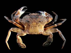
#Fishing - Marine Minister Michael Creed signed into law conservation measures concerning Irish velvet crab stocks as he hosted the 12th meeting of the National Inshore Fisheries Forum (NIFF) today, Wednesday 27 September.
The Inshore Fisheries Forum structures, which include the NIFF and six Regional Inshore Fisheries Forums (RIFFs), were established in 2014 to foster stakeholder-led development of proposals for the inshore fishing sector.
As well as moved to protect Irish velvet crab, the minister also introduced measures to regulate fishing activities affecting Natura 2000 sites at Hook Head and the Saltee Islands.
Regulations signed by Minister Creed today will introduce a Minimum Conservation Reference Size (MCRS) of 65mm for velvet crab that will apply to Irish sea fishing boats from 1 January 2018.
This measure was initially developed by the West Regional Inshore Fisheries Forum (RIFF) with advice from the Marine Institute. The proposal was brought to the minister last year by the NIFF, and a public consultation on the measure was held at the end of 2016.
Velvet crab are fished all year, but mainly in the March to October period, and they are predominantly a by-catch in the lobster fishery. Landings of velvet crab into Ireland were 406 tonnes in 2015, higher than any year since 2004, and were valued at just under €808,000. Over 80% of velvet crabs are landed by vessels less than 10 metres in length.
Additionally, a Fisheries Natura Declaration signed by Minister Creed today will restrict fishing using dredge and trawling gear for scallop fishing to protect certain sensitive habitats in Natura 2000 conservation sites off the southeast coast of Wexford from 30 November.
The Natura 2000 sites include the Hook Head and Saltee Islands SACs (Special Areas of Conservation). The declaration also sets down monitoring and notification requirements for boats fishing using dredge and trawling gear within these habitats.
These gear and monitoring measures were developed through industry members working with the Marine Institute and Bord Iascaigh Mhara (BIM) to address risks to sensitive habitats in the Hook Head and Saltee Islands SACs. The risks were identified by the Marine Institute in a 2014 risk assessment report of sea-fishing activities in Natura 2000 sites in the Irish Sea.
Industry members – including individual scallop fishermen, members of the Southeast RIFF and representatives of the Irish South and East Fish Producers Organisation (ISEFPO) – met with the Marine Institute and BIM through 2015 and 2016 to develop risk mitigation proposals for the fishery. A public consultation on the resulting Mitigation Response Plan was carried out in 2016.
These measures are being introduced following full consultation with the Inshore Fisheries Forum structures.
“Heading into their third year, the forums have taken a lead in tackling conservation issues and changing practices with a view to long-term sustainability,” said Minister Creed. “I welcome the support these measures have received from the Forums which reflects the mature approach this sector is taking in dealing with its own challenges.”
Minister Creed and the NIFF discussed the implementation of the new measures and the status of other measures under review for important stocks such as lobster, brown crab and razor clams.
The minister also discussed the impact of Brexit on the fishing sector and the UK’s intention to withdraw from the London Fisheries Convention, which governs access to waters inside the 12-mile limit.
Commenting on issues arising for the sector from Brexit, Minister Creed noted: “While the implications of Brexit are far from clear at this point in time, I will continue to highlight Irish fisheries concerns on the EU agenda and work with other impacted EU member states and the Barnier team to ensure that fisheries are not isolated in the overall negotiations on a new EU/UK relationship.”
Offshore Earthquakes & Deep Sea Corals Among 26 Projects Awarded €45m By SFI
#MarineScience - Offshore earthquakes and cold water coral in subsea canyons in Irish waters are among 26 projects awarded €45 million in research investment through the Science Foundation Ireland's Investigators Programme, announced last week by Minister of State for Training and Skills, John Halligan.
“This funding recognises some of Ireland’s top researchers and enables them to advance vital research areas in Ireland,” said the minister. “I am confident that the teams being supported will generate important new scientific breakthroughs.”
The 26 research projects will support 94 research positions over the next five years.
“In addition, today’s investment provides 20 companies with access to invaluable expertise and infrastructure across the country,” said Minister Halligan. “These collaborations between industry and academia are integral to further enhancing Ireland’s reputation for research excellence.”
To strengthen and accelerate research in key strategic areas of national interest, Science Foundation Ireland (SFI) collaborates with several funding agencies and public bodies through the SFI Investigators Programme.
Six of the research projects received co-funding worth a total of €3 million from Teagasc, the Geological Survey of Ireland, the Marine Institute, and the Environmental Protection Agency. The Marine Institute and the Geological Survey of Ireland are co-funding two marine science awards with SFI to the value of €2.65 million.
Professor Sergei Lebedev of the Dublin Institute of Advanced Studies (DIAS) has been awarded €1,248,989 to investigate the structure, evolution and seismic hazard of Ireland’s offshore territory.
With 90% of Ireland’s territory offshore, it represents vast resources but also hazards, with offshore earthquakes posing the biggest risk with the potential to trigger undersea landslides and tsunamis.
Prof Lebedev’s team will for the first time deploy an array of ocean-bottom, broadband seismometers offshore which, together with existing arrays onshore, will cover the entire Irish territory.
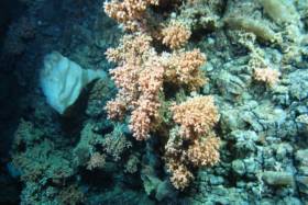
Professor Andy Wheeler of University College Cork has been awarded €874,329 to explore and monitor cold water corals in submarine canyons in the deep ocean and determine their sensitivity to climate change and fisheries and oil industry impacts.
Prof Wheeler’s team will used advanced robotic technology and novel 3D visualisation and will make recommendations for sustainable responsible fisheries and hydrocarbon activity and for effective management during climate change.
Dr Ciaran Kelly, R&D manager at the Marine Institute, said, “The Marine Institute is delighted to partner with SFI again in co-funding these important projects through the investigators programme, together with our INFOMAR programme partners, Geological Survey of Ireland.
“This collaboration will accelerate our knowledge of key processes of the deep ocean bringing longstanding benefits to society.”
For more information on the 26 projects funded through the SFI Investigators Programme see www.sfi.ie.
Groundfish Survey Off North West Coast This October
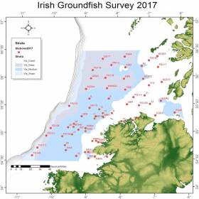
#MarineNotice - The Marine Institute advises that the annual Irish Groundfish Survey (IGFS2017) will be carried out off the North West Coast of Ireland between Tuesday 3 and Saturday 14 October, in fulfilment of Ireland’s Common Fisheries Policy obligations.
The IGFS is a demersal trawl survey consisting of approximately 45 fishing hauls of 30 minutes duration each in ICES area VIa. Fishing in 2017 will take place within a two nautical mile radius of these 45 positions, the approximate locations of which are noted in Marine Notice No 39 of 2017.
The survey will be conducted by the RV Celtic Explorer (Callsign: EIGB), which will display all appropriate lights and signals during the survey and will also be listening on VHF Channel 16. The vessel will be towing a high headline GOV 36/47 demersal trawl during fishing operations.
This survey is to determine the relative annual abundance and distribution of commercially exploited fish stocks, in particular assessment of recent recruitment. In addition, other species of national importance are sampled along with physical and chemical oceanographic parameters.
The Marine Institute requests that commercial fishing and other marine operators keep a two nautical mile area around the tow points clear of any gear or apparatus during the survey period outlined above.
While there is no statutory provision for the loss of gear at sea, the Marine Institute will make every effort to avoid gear, adequately marked according to legislation, that may be encountered in the notified areas. In the event that an operator has static gear or other obstructions within 2nm of the trawl points, it is the responsibility of the owner to notify the survey managers or vessel directly.
This should be communicated by identifying specifically which ‘Prime Station’ is of concern using the appendix and contact details provided in Marine Notice No 39 of 2017, a PDF of which is available to read or download HERE.
It is not required to provide positional details of commercial operations beyond 3-4nm of the survey points provided. Specifics of any fishing gear or other obstructions that are known and cannot be kept clear of these survey haul locations can be notified using the contact details provided in the above Marine Notice.
Call For Marine Researchers To Apply For Fulbright Irish Awards

#MarineScience - The Marine Institute and the Fulbright Commission are once again offering a unique opportunity for an Irish PhD candidate or scholar to travel to the USA to research in the fields of marine science or a marine-related business sector.
The Fulbright Commission is seeking applicants with academic and personal excellence, strong leadership potential and a commitment to being a Fulbrighter. The commission is particularly interested in receiving applications for this award from candidates who are exploring:
- Marine Sensor Technologies and Observation Systems
- Maritime Economics
- Marine Spatial Planning
- Maritime Law and Security
- Renewable Ocean Energy
- Marine Biotechnology (including Functional Foods)
- Marine Environment
- Oceanographic Modelling
- Shipping
- Seafood Safety
- Ecosystems-based Fisheries Management
- Big Data, and Sustainable Development
The 2018-2019 Fulbright Irish Awards supporting Irish and EU citizens to study, research or teach in the USA are now open for application. All applications are due by 4pm on Tuesday 31 October.
These globally-recognised and prestigious awards, operating between the United States and 155 countries, were founded by Senator J William Fulbright in 1946 “to expand the boundaries of human wisdom, empathy and perception” through educational and cultural exchange.
As a Fulbright Scholar, Dr Triona McGrath — a post-doctoral researcher at NUI Galway — visited Scripps Institution of Oceanography in San Diego in 2013 on a trip funded by the Marine Institute to develop her analytical skills in ocean carbon chemistry.
Dr McGrath has been researching ocean climate change since 2008 and highlights the value of her experience in the USA, saying: “The opportunity provided me with a wealth of information of how others work and increasing my knowledge at an international level.”
Dr McGrath’s team continues to monitor levels of carbon dioxide in Irish marine waters to determine the level of carbon in the ocean and subsequent increase in ocean acidity.
Along with her colleagues, Dr McGrath published the first rates of ocean acidification for Irish offshore waters and the first baseline dataset of carbon parameters in Irish coastal waters.
This data is crucial for our understanding of the future health of our oceans, and can provide information to determine the impacts of ocean acidification on marine ecosystems.
The Fulbright Commission in Ireland recently launched its new website and a promotional video called ‘Across the Water’ created by IADT student Gary Boyd, which also features Dr McGrath.
Marine Notice: Spiddal Wave Energy Test Site Decommissioning Works
#MarineNotice - The latest Marine Notice from the Department of Transport, Tourism and Sport (DTTAS) advises of the decommissioning of the wave energy test site in Galway Bay.
The decommissioning of the Marine Institute's wave energy site will involve the removal of four cardinal marks and a wave monitoring data buoy, and the establishment of a new special mark denoting the presence of the Galway Bay Subsea Observatory on the seabed at the site off Spiddal.
The Chateau Thierry (Callsign EIHK6) was scheduled to arrive in Galway Bay this week between Monday 11 and next Monday 18 September. This operation is expected to last two days, depending upon weather or other operational conditions.
It is anticipated that the decommissioning operation will be completed on or before Tuesday 19 September.
The Chateau Thierry will display appropriate lights and markers. The work vessel will be broadcasting and listening on VHF Channel 16 during the decommissioning.
Full details of co-ordinated of the relevant work areas are included in Marine Notice No 38 of 2017, a PDF of which is available to read or download HERE.
Primary School Marine Science Art Project Shortlisted For Top Award
#MarineScience - Build Your Own Unknown, a marine science and art project by fourth-class pupils at Cregmore National School in Co Galway, has been shortlisted for the Allianz Business to Arts Awards.
As previously reported on Afloat.ie, the Cregmore pupils worked with artist Louise Manifold to produce their installation and short film, using images and footage from the ROV Holland I for inspiration in recreating the discovery of the Moytirra deep-sea hydrothermal vents in 2011.
The project — which places art, marine science and technology in the heart of the classroom — also involved TULCA in partnership with the Marine Institute’s Explorers Education Programme and marine scientist Dr Andy Wheeler from UCC.
Marine Institute chief executive Dr Peter Heffernan congratulated the team on their achievement and wished them luck for awards night.
“One of the greatest outcomes of the Build Your Own Unknown project was being able to provide an opportunity for artists, marine scientists and educators to work together to help engage and increase children, teachers and the wider community’s awareness about the importance of our ocean,” said Dr Heffernan.
The Allianz Business to Arts Awards recognise and champion the spirit of collaboration between businesses, artists and arts organisations that develop creative partnerships; bringing the arts and artists into mutually beneficial relationships across society.
The winners of this year’s Allianz Business to Arts Awards will be announced later this evening (Monday 4 September).
New Shellfish Safety Reporting Website Goes Live
#Shellfish - The Marine Institute, as the EU designated national reference laboratory for shellfish toxins and shellfish microbiology in Ireland, has launched a new shellfish safety website.
Incorporating a range of user friendly info-graphics and maps, the site will provide information on recent trends analysis as well as current status of shellfish production areas.
The new website has been launched to provide regulatory authorities, shellfish producers, processors, hospitality industry, public health officials and the general public with the most up-to-date information available.
The Marine Institute carries out a year-round national testing programme to ensure that all shellfish are safe before being placed on the market for human consumption.
“With over 100 coastal aquaculture production areas farming a variety of shellfish species, and many more offshore areas being fished commercially, it is essential that an efficient and accurate method of communicating these test results is in place,” said Joe Silke, manager of shellfish safety for the Marine Institute.
The open status of shellfish production areas is necessary before the product can be placed on the market. This open status depends on clear tests being obtained for a comprehensive range of shellfish toxins, and in addition, harmful algal species from water samples must be tested on an ongoing basis. In addition, microbiological classification status is assigned on the basis of ongoing testing.
“Placing shellfish on the market requires speedy testing and reporting laboratory results. The Institute has strived towards providing state of the art processes and this new website will provide current status and a range of extra information that was not previously online,” added Silke.
All shellfish safety data are continuously compiled on databases at the Marine Institute and are essential to assign the appropriate ongoing status to the shellfish production areas.
The new website, the first phase of which is now available online, will feature new information such as the progress of sample analysis through the lab, recent trends in toxin and harmful algal concentrations, and maps to indicate the national trends.
Further features will be rolled out in the coming months.


, and Dermot O’Kane, Head of Sales, Esri Ireland. Esri Ireland is announcing that its digital mapping system is helping DURL to prevent 13 million litres of polluted wastewater from entering Dublin rivers annually, by locating misconnected household appliances that are expelling polluted water")


 Michael Murphy Schull Harbour Sailing Club (SHSC), Eric Coogan Heineken Ireland, Mark Murphy, Commodore SHSC, Jack Allen SHSC, Carmel O'Regan SHSC, Cornelious Ndlovu, Schull Harbour Hotel Operations Manager and Derval Murphy SHSC")


