Menu

Ireland's sailing, boating & maritime magazine

Inland afloat headers


Displaying items by tag: Marine Science News

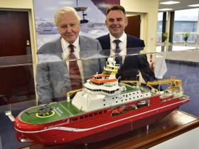
#BoatyMcBoatface - Sir David Attenborough along with more than 1,000 people attended the keel-laying ceremony of a new £150m polar research vessel at a UK shipyard yesterday.

Construction of RSS Sir David Attenborough was officially started by the world-renowned naturalist and broadcaster, after whom the ship is named. Noting earlier this year the public through an online poll originally had chosen a different name 'Boaty McBoatface' as a clear favourite that proved controversial. The newbuild's robotic underwater vehicle will however be named 'Boaty McBoatface'.

At the ceremonial event at Cammell Laird's shipyard site, Birkenhead in Liverpool City Region, Sir David started the “keel laying” process by initiating the lifting by crane of the first hull unit on to the construction berth. This unit, weighing around 100 tonnes, includes part of the ship’s keel and is the first of 97 units which will be erected to form the entire hull of the research ship.

When the ship sets sail in 2019, the RRS Sir David Attenborough will provide a research base to help scientists tackle some of the most important issues facing humanity, including climate change, future sea level rise and the impact of environmental change on marine life.

Speaking at the ceremony Sir David Attenborough said: “It is an honour to be invited to take part in the keel-laying ceremony. The Polar Regions are not only critical for understanding the natural world but they also have an enormous appeal for journalists, broadcasters and the public.

“I have had several opportunities to experience the power of these places first hand. This new ship will ensure that scientists have access to these enigmatic regions to uncover secrets that we can only imagine at this point. Scientists working on this new ship will inform everyone about our changing world for generations to come.”


Published in Marine Science

#NewCentre – The Examiner writes that over the weekend, a maritime facility which will power the 'blue economy" was opened in Ringaskiddy, Co Cork, by Taoiseach Enda Kenny.

The 4,700m sq, five-storey Beaufort Building with wave simulators, test tanks, workshops and offices provides Ireland with world-class infrastructure for renewable energy and maritime research.

Named after the Irish hydrographer and globally adopted Beaufort Wind Scale creator, Rear Admiral Francis Beaufort, the Beaufort building will house the headquarters of the multi-institutional home to Science Foundation Ireland's Marine Renewable Energy Ireland and the LIR National Ocean Test Facility.

For more on this new facility located in lower Cork Harbour, the newspaper has a report here.

Published in Marine Science

#BlueEconomy - Dr Peter Heffernan, CEO of the Marine Institute is to be the guest speaker of Cork Chamber's June Business Breakfast on Thursday 25th June in the Clarion Hotel.

The Blue Economy is seen as hugely important for the island of Ireland and Cork is naturally well positioned to reap the benefits of this growth, boasting the second largest natural harbour in the world. Focused around the Ringaskiddy area, the Irish Maritime Research Cluster (IMERC) are at the centre of promoting Ireland as a world renowned maritime and research development location.

It is also the site of the National Maritime College of Ireland, the Irish Naval Service and the UCC Beaufort Laboratory.

Dr Peter Heffernan was appointed as CEO of the Marine Institute in 1994. The Marine Institute is Ireland's National agency for marine Research Technology Development & Innovation (RTDI).

Dr Heffernan obtained PhD in marine science from the National University of Ireland, Galway. He held a post-doctoral position at University of Georgia (USA) in 1985, he has published over 40 scientific papers, has over 20-years of experience in leading marine science policy developments at national, EU and trans-Atlantic levels.

This is an opportunity for Chamber members to get an insight into the huge potential in the marine industry in Ireland and in particular, in the Southern Region.

Members of the public are also invited to the Cork Chamber event where further information, registration and event times are available through this website link HERE.

Published in Marine Science

#SeaforSociety - An open day saw more than 150 children from five schools from Dublin, Cork, Galway, and Mayo visit the Marine Institute's research vessel, the RV Celtic Explorer, as well as Galway Atlantaquaria, as part of the EU FP7 Sea for Society project to raise awareness of our ocean, this week in Galway city.

The Sea for Society collective action aims to shape the concept of a "Blue Society" and improve Europe's understanding on the relation between the ocean and our daily life activities. "As part of the Sea for Society FP7 project in Ireland, we provided the opportunity for children to see and take part in a wide range of activities including meeting with marine scientists, researchers and the Captain of the RV Celtic Explorer, as well as the team from AquaTT and marine experts at the aquarium," explained Cushla Dromgool-Regan, Marine Institute.

On the vessel the children meet with the fisheries research team who showed a wide range of fish from the deep ocean. The seabed mapping researchers showed bathymetry mapping images of key shipwrecks around Ireland as well as the newly discovered submarine mountain ranges mapped by the RV Celtic Explorer on its latest expedition from Newfoundland to Galway.

The remotely operated vehicle ROV Holland I, which is to be used in the vessels next expedition filming cold water corals on the Porcupine bank, was also on display. This
provided a key opportunity for the children to learn about marine history, marine technology well as taking part in some simple experiments demonstrating pressure.

AquaTT also asked the teachers and children to think about the small changes we can make in our lifestyle which have a significant impact on the ocean, such as using less water, eating fish that has been caught sustainably, disposing plastics in a responsible way, to taking part in beach cleans.

Galway Atlantaquaria provided tactile learning opportunities where the students got to touch and see marine animals native to Irish seashores and ocean.

Teachers and pupils alike described the event as a unique and wonderful experience. "I've attended many trips with the school, but this one really stood out. We learned so much, ranging from how phytoplankton in our ocean provide up to 50 percent of the oxygen we breathe, to how to tell the age of a fish using their ear bones - otoliths. Raising awareness of our ocean and the impact that the ocean has on us is so important," said Maire Ni Fhoghlu, from Gaelscoil Uileog de Burca, Claremorris.

The children who attended the open day had taken part in the Marine Institute's Explorers Education Programme which is run by Galway Atlantaquaria, Blackrock Education Centre, SeaLife – Bray and Lifetime Lab in Cork, and is also supported by other education centres in Mayo and Galway.

"The excellent marine activities and projects completed this year by the schools were evident by the enthusiasm and knowledge of the children who visited the Celtic Explorer. For an island nation it is heartening to see that the children are learning about our ocean, understanding the importance of scientific marine research as well as taking personal responsibility for caring for our marine environment," Cushla Dromgool-Regan further said.

The Explorers Education programme also provides a range of cross curricular teaching resources and lesson plans for all primary schools to freely download at www.explorers.ie 

In addition for more details on the programme details click HERE.

Published in Marine Science

#NewUCCcentre – According to a report in the Irish Examiner, University College Cork has been granted permission to facilitate site works for the development of a major maritime research centre on the southside of Cork harbour.

The university applied at the end of July for the works, on a site of 15 acres next to Cork Institute of Technology's National Maritime College of Ireland, (which held it's Open Day on Tuesday this week) in Ringaskiddy.

The development also adjoins the under-construction Beaufort Laboratory, for which permission was given on foot of a 2011 application to Cork County Council. For more details among a series of projects listed under planning notes, click HERE.


Published in Marine Science

#INFOMARseminar- The annual INFOMAR Seminar is to take place in Waterford City over the course of two-days (22-23 October) at the Tower Hotel opposite the city's landmark Reginald Tower.

The seminar will include an update on Ireland's national seabed mapping programme featuring survey operations and coverage, future plans, associated research along with poster sessions. To register for a free place at the seminar, click HERE

INFOMAR which stands for The INtegrated Mapping FOr the Sustainable Development of Ireland's MArine Resource programme is a joint venture between the Geological Survey of Ireland and the Marine Institute.

An area covering some 125,000 km2 of Ireland's most productive and commercially valuable inshore waters is carried out by INFOMAR. They produce integrated mapping products covering the physical, chemical and biological features of the seabed.

The following research vessels operate for INFORMAR the RV Keary, Geo and Cosantóir Bradán.


Published in Marine Science

#UnderwaterWaterford – Following our port snapshot of Waterford Harbour shipping this morning which included a dredger, INFOMAR takes us on a 3D-fly-through of the estuary (in reverse direction) showing the seabed as its winds its way upriver to the city, writes Jehan Ashmore.

The 3D imagery shows (click link, scroll down and enlarge video) the varying depths and channel widths of the shipping lane along Waterford estuary taken from the research vessel, the RV Keary.

As mentioned above this is where a dredging campaign is currently underway, notably for ships using Belview Por, the main terminal facility of the Port of Waterford Company which has contracted WD Mersey (1983/1,696grt) to carry out the work.

Since late last month dredging operations along the estuary has involved the spoil to be dumped south-west off Hook Head.

As for the role of RV Keary this took place in 2011 and was the first INFOMAR survey leg to be carried out by the South African built aluminium constructed catamaran. The survey took two-months to complete and was conducted in preparation to hosting the second Tall Ships Festival held that year.

The seabed survey mapping of RV Keary concentrated on the navigational channel while the surrounding shallower waters were tasked to a smaller RIB based craft, RV Geo. Together this was the first occasion the pair of GSI vessels worked on a survey.

The 15m RV Keary is a state-run marine research survey vessel commissioned for and operated by the Geological Survey of Ireland (GSI). As reported in 2012, the Central Fisheries Board cutter Cosantoir Bradan was chartered by GSI in an RV role.

The vessels primary function is to provide an inshore survey capability for the national INtegrated Mapping FOr the Sustainable Development of Ireland's MArine Resource - in short INFOMAR.

In addition assistance in the INFOMAR programme which is funded by the Department of Communications, Energy and Natural Resources, is also made available from the Marine Institute's pair of research vessels, RV Celtic Voyager and larger fleetmate RV Celtic Explorer.

To keep track of GSI vessels current locations, click this map-link.

Published in Ports & Shipping

#EurOCEAN – CEO of the Marine Institute, Dr Peter Heffernan yesterday welcomed the announcement of the EurOCEAN 2014 Conference in Rome recalling the very successful EurOCEAN 2004 Galway Conference and the 2004 Galway Declaration on Marine Science & Technology.

The Galway Declaration, and subsequent EurOCEAN Conference Declarations (Aberdeen, 2007 and Ostend, 2010), have made significant contributions to the EU's Marine Research Agenda and the Integrated Maritime Policy for the European Union (2007). He looked forward to an equally influential Declaration from the Rome Conference.

EurOCEAN 2014 (7th – 9th October 2014, Rome) will bring together marine scientists across the broad range of disciplines with policymakers, industry and NGOs, to develop a common vision on achieving an ecosystem approach to the management of Europe's marine resources as a fundamental requirement for sustainable Blue Growth. Highlighting the importance of Blue Growth and of commercially-driven, problem-oriented research, EurOCEAN 2014 will equally emphasize that a growing and sustainable maritime economy will also require a much greater knowledge and understanding of marine ecosystem functioning and resilience.

For 2.5 days EurOCEAN 2014 cover a combination of plenary sessions and parallel workshops, organized around societal, policy and regional challenges. The conference programme will reflect the high-level messages of the European Marine Board's Navigating the Future-IV Foresight Report.

The EurOCEAN 2014 conference is part of the successful EurOCEAN Conference Series initiated in late 1990s to provide a regular focal point for the marine and maritime research community and stakeholders to interact with European and member state policymakers and programme managers, to discuss and respond to new marine science and technology developments, challenges and opportunities.

EurOCEAN 2014 is an official event of the Italian EU Presidency and is co-organized by the European Marine Board, European Commission and the Italian EMB members, CNRS, OGS and CoNISMA.

For further information see: http://eurocean2014.eu/


Published in Marine Science
8th October 2013

INFOMAR Annual Seminar 2013

#INFOMARseminar – A two-day INFOMAR seminar hosted by the Geological Survey of Ireland and the Marine Institute is to start tomorrow (Wednesday 9 October) in Limerick City.

Integrated Mapping for the Sustainable Development of Ireland's Marine Resources (INFOMAR) is a joint venture between the Geological Survey of Ireland and the Marine Institute. The programme is the successor to the Irish National Seabed Survey.

INFOMAR covers some 125,000 km² of Irelands most productive and commercially valuable inshore waters.

The annual INFOMAR conference will see seminar delegates meet in the Pavilion of the University of Limerick (UL) which is to be hosted by the Mobile & Marine Robotics Research Centre.

The seminar will include an update on Ireland's national seabed mapping programme including survey operations and coverage, future plans, associated research along with poster sessions.

Places to attend the free seminar were made open to all, however registration has now closed as attendance is at capacity.

To request a late registration, contact Kevin Sheehan by email: [email protected], should places become available.

For further information visit: www.eventelephant.com/infomarannualseminar2013


Published in Marine Science

#ResearchShipTime – The Marine Institute are calling for applications for those wishing to accept ship-time on board the research vessels RV Celtic Explorer and RV Celtic Voyager in 2014 and 2015.

Applications for ship-time must be submitted using Research Vessel Operations' on-line 'Survey Planning System' (SPS) before 20th September 2013.

Applicants can get further information from the Apply for Ship-time pageApplications for ship-time must be submitted using Research Vessel Operations' on-line 'Survey Planning System' (SPS) before 20th September 2013.

Applicants can get further information from the Apply for Ship-time page on the Marine Institute website www.marine.ie and contact [email protected] to obtain login details to SPS.

Applicants should read The Vessel Charter Guidelines (.doc 256 KB) prior to submitting their application.

Applicants may seek grant-aid to cover all or part of the vessel charter costs.

For information on eligibility for grant-aid and additional application requirements please refer to the Grant-Aid Guidelines

Note: Applications for grant-aid will only be accepted for ship-time in 2014. Applications for grant-aid for ship-time in 2015 will be accepted in 2014.

Persons considering making an application for shiptime for training purposes are advised to consult with Strategic Marine Alliance for Research and Training (SMART) via [email protected].

This marine science partnership programme is designed to standardise and optimise ship based training for 3rd level students and provide nationally accredited ship based training activities.

The RV Celtic Explorer will once again be making transatlantic passages to complete a survey in Newfoundland waters in April 2014 (Westward) and May (Eastward) and a targeted call for applications to utilise these transects is being included in this year's call.

Applications are invited from researchers to utilise to utilise the vessel for up to a 14 day period on the western transect starting in mid-April 2014.

The initiative is planned to coincide with a planned charter survey in Newfoundland waters in April/May 2014 and is a precursor to future transatlantic co-operative research as outlined at the recent Atlantic Strategy meeting which included EU, US and Canadian Partners.

The PIP funding scheme will accept proposals for part funding of shiptime and full funding of associated research. For further information please go to their website: http://www.pip.ie/page/1


Published in Marine Science
Page 1 of 3

General Information on using Waterways Ireland inland navigations

Safety on the Water

All users of the navigations are strongly recommended to make themselves aware of safety on the water for whatever activity they are involved in and to read the advice offered by the various governing bodies and by:

The Dept. of Transport, Ireland: www.gov.ie/transport and The Maritime and Coastguard Agency, UK, The RNLI – Water Safety Ireland for information in terms of drowning prevention and water safety.

Registration of Vessels

All vessels using the Shannon Navigation, which includes the Shannon-Erne Waterways and the Erne System must be registered with Waterways Ireland. Only open undecked boats with an engine of 15 horsepower or less on the Shannon Navigation, and vessels of 10 horsepower or less on the Erne System, are exempt. Registration is free of charge.

Craft registration should be completed online at: https://www.waterwaysireland.org/online-services/craft-registration

Permits for use of the Grand and Royal Canals and the Barrow Navigation

All vessels using the Grand and Royal Canals and the Barrow Navigation must display appropriate valid Permit(s) i.e A Combined Mooring and Passage Permit (€126) and if not intending to move every five days, an Extended Mooring Permit (€152).

Permit applications should be completed online at: https://www.waterwaysireland.org/online-services/canal-permits

Passage on the Royal and Grand Canals – Dublin Area

For boat passage through the locks east of Lock 12 into / out of Dublin on either the Royal or Grand Canals, Masters are requested to contact the Waterways Ireland Eastern Regional Office (M-F 9.30am-4.30pm) on tel: +353(0)1 868 0148 or email [email protected] prior to making passage in order to plan the necessary lock-keeping assistance arrangements.

On the Grand Canal a minimum of two days notice prior to the planned passage should be given, masters should note that with the exception of pre-arranged events, a maximum of 2 boats per day will be taken through the locks, travelling either east or west.

Movements in or out of the city will be organised by prior arrangement to take place as a single movement in one day. Boaters will be facilitated to travel the system if their passage is considered to be safe by Waterways Ireland and they have the valid permit(s) for mooring and passage.

Newcomen Lifting Bridge

On the Royal Canal two weeks’ notice of bridge passage (Newcomen Lifting Bridge) is required for the pre-set lift date, and lock assistance will then also be arranged. A minimum of 2 boats is required for a bridge lift to go ahead.

Waterways Ireland Eastern Regional Office (Tel: +353(0)1 868 0148 or [email protected] ) is the point of contact for the bridge lift.

A maximum number of boats passing will be implemented to keep to the times given above for the planned lifts (16 for the Sat / Sun lifts & 8 for the weekday lifts). Priority will be given on a first come first served basis.

On day of lift, boaters and passengers must follow guidance from Waterways Ireland staff about sequence of passage under bridge & through Lock 1, and must remain within signed and designated areas.

Events Held on the Waterways

All organised events taking place on the waterways must have the prior approval of Waterways Ireland. This is a twelve week process and application forms must be accompanied with the appropriate insurance, signed indemnity and risk assessment. The application should be completed on the Waterways Ireland events page at :

https://www.waterwaysireland.org/online-services/event-approval

Time Limits on Mooring in Public Harbours

On the Shannon Navigation and the Shannon-Erne Waterway craft may berth in public harbours for five consecutive days or a total of seven days in any one month.

On the Erne System, revised Bye Laws state that: No master or owner shall permit a vessel, boat or any floating or sunken object to remain moored at or in the vicinity of any public mooring, including mooring at any other public mooring within 3 kilometres of that location, for more than 3 consecutive days and shall not moor at that same mooring or any other public mooring within 3 kilometres of that location within the following 3 consecutive days without prior permission by an authorised official.

Winter Mooring on the Shannon Navigation and Shannon Erne Waterway

Winter mooring may be availed of by owners during the period 1 Nov to 31 Mar by prior arrangement and payment of a charge of €63.50 per craft. Craft not availing of Winter Mooring must continue to comply with the “5 Day Rule”. Winter Mooring applications should be completed online at : https://www.waterwaysireland.org/online-services/winter-moorings-booking

Owners should be aware that electricity supply and water supply to public moorings is disconnected for the winter months. This is to protect against frost damage, to reduce running costs and to minimise maintenance requirements during the winter months.

Vessel owners are advised that advance purchasing of electricity on the power bollards leading up to the disconnection date should be minimal. Electricity credit existing on the bollards will not be recoverable after the winter decommissioning date. Both services will be reinstated prior to the commencement of the next boating season.

Smart Cards

Waterways Ireland smart cards are used to operate locks on the Shannon Erne Waterway, to access the service blocks, to use the pump-outs along the navigations, to avail of electrical power at Waterways Ireland jetties.

Berthing in Public Harbours

Masters are reminded of the following:

  • Equip their vessel with mooring lines of appropriate length and strength and only secure their craft to mooring bollards and cleats provided for this purpose.
  • Ensure the available berth is suitable to the length of your vessel, do not overhang the mooring especially on finger moorings on floating pontoon moorings.
  • Ensure mooring lines, electric cables and fresh water hoses do not create a trip hazard on public jetties for others users.
  • Carry sufficient fenders to prevent damage to your own vessel, other vessels and WI property.
  • Allow sufficient space between your vessel and the vessel ahead /astern (c.1m) for fire safety purposes and /or to recover somebody from the water.
  • Do not berth more than two vessels side by side and ensure there is safe access/egress at all times between vessels and onto the harbour itself.
  • Do not berth in such a way to prevent use of harbour safety ladders, slipways or pump-outs.
  • Do not allow the bow of your vessel to overhang the walkway of a floating mooring thus creating a hazard for others with an overhanging anchor or bow fendering.
  • Animals are not allowed to be loose or stray at any time.
  • Harbour and jetty infrastructure such as railings, power pedestals, fresh water taps, electric light poles, safety bollards, ladders etc are not designed for the purpose of mooring craft , they will not bear the strain of a vessel and will be damaged.
  • At Carrybridge on the Erne System, Masters of vessels are not permitted to use stern on mooring. Masters of vessels must use the mooring fingers for mooring of vessels and for embarkation / disembarkation from vessels.

Passenger Vessel Berths

Masters of vessels should not berth on passenger vessel berths where it is indicated that an arrival is imminent. Passenger vessels plying the navigations generally only occupy the berths to embark and disembark passengers and rarely remain on the berths for extended periods or overnight.

Lock Lead-in Jetties

Lead-in jetties adjacent to the upstream and downstream gates at lock chambers are solely for the purpose of craft waiting to use the lock and should not be used for long term berthing.

Vessel Wake

Vessel wake, that is, the wave generated by the passage of the boat through the water, can sometimes be large, powerful and destructive depending on the hull shape and engine power of the vessel. This wake can be detrimental to other users of the navigation when it strikes their craft or inundates the shoreline or riverbank. Masters are requested to frequently look behind and check the effect of their wake / wash particularly when passing moored vessels, on entering harbours and approaching jetties and to be aware of people pursuing other activities such as fishing on the riverbank.

Speed Restriction

A vessel or boat shall not be navigated on the Shannon Navigation at a speed in excess of 5 kph when within 200 metres of a bridge, quay, jetty or wharf, when in a harbour or canal or when passing within 100 metres of a moored vessel or boat.

Vessels navigating the Shannon-Erne Waterway should observe the general 5 kph speed limit which applies along the waterway. This is necessary in order to prevent damage to the banks caused by excessive wash from vessels.

Vessels navigating the Erne System should observe the statutory 5kt / 6mph / 10kph speed limit areas.

A craft on the Royal and Grand canals shall not be navigated at a speed in excess of 6km per hour.

A craft on the Barrow Navigation shall not be navigated at a speed in excess of 11km per hour except as necessary for safe navigation in conditions of fast flow.

Bank Erosion

Narrow sections of all the navigations are particularly prone to bank erosion due to the large wash generated by some craft. Masters are requested to be vigilant and to slow down to a speed sufficient to maintain steerage when they observe the wash of their craft inundating the river banks.

Unusual Waterborne Activity

Unusual waterborne vessels may be encountered from time to time, such as, hovercraft or amphibious aircraft / seaplanes. Masters of such craft are reminded to apply the normal “Rule of the Road” when they meet conventional craft on the water and to allow extra room to manoeuvre in the interest of safety.

Sailing Activity

Mariners will encounter large numbers of sailing dinghies from late June to August in the vicinity of Lough Derg, Lough Ree and Lower Lough Erne. Sailing courses are marked by yellow buoys to suit weather conditions on the day. Vessels should proceed at slow speed and with due caution and observe the rules of navigation when passing these fleets, as many of the participants are junior sailors under training.

Rowing

Mariners should expect to meet canoes and vessels under oars on any part of the navigations, but more so in the vicinity of Athlone, Carrick-on-Shannon, Coleraine, Enniskillen and Limerick. Masters are reminded to proceed at slow speed and especially to reduce their wash to a minimum when passing these craft as they can be easily upset and swamped due to their very low freeboard and always be prepared to give way in any given traffic situation.

Canoeing

Canoeing is an adventure sport and participants are strongly recommended to seek the advice of the sport’s governing bodies i.e Canoeing Ireland and the Canoe Association of Northern Ireland, before venturing onto the navigations.

Persons in charge of canoes are reminded of the inherent danger to these craft associated with operating close to weirs, sluice gates, locks and other infrastructure particularly when rivers are in flood and large volumes of water are moving through the navigations due to general flood conditions or very heavy localised precipitation e.g. turbulent and broken water, stopper waves. Shooting weirs is prohibited without prior permission of Waterways Ireland.

Canoeists should check with lockkeepers prior entering a lock to ensure passage is done in a safe manner. Portage is required at all unmanned locks.

Canoe Trail Network – "Blueways"

Masters of powered craft are reminded that a canoe trail network is being developed across all navigations and to expect more organised canoeing along these trails necessitating slow speed and minimum wash when encountering canoeists, rowing boats etc

Rockingham and Drummans Island Canals – Lough Key

It is expected that work on Rockingham and Drummans Island Canals on Lough Key will be completed in 2021. Access to these canals will be for non-powered craft only, eg canoes, kayaks, rowing boats.

Fast Powerboats and Personal Watercraft (Jet Skis)

Masters of Fast Powerboats (speed greater than 17kts) and Personal Watercraft (i.e.Jet Skis) are reminded of the inherent dangers associated with high speed on the water and especially in the confines of small bays and narrow sections of the navigations. Keeping a proper look-out, making early alterations to course and /or reducing speed will avoid conflict with slower vessels using the navigation. Personal Watercraft are not permitted to be used on the canals.

Towing Waterskiers, Wakeboarders, Doughnuts etc

Masters of vessels engaged in any of these activities are reminded of the manoeuvring constraints imposed upon their vessel by the tow and of the added responsibilities that they have to the person(s) being towed. These activities should be conducted in areas which are clear of conflicting traffic. It is highly recommended that a person additional to the master be carried to act as a “look-out” to keep the tow under observation at all times.

Prohibition on Swimming

Swimming in the navigable channel, particularly at bridges, is dangerous and is prohibited due to the risk of being run over by a vessel underway in the navigation.

Age Restrictions on operating of powered craft

In the Republic of Ireland, Statutory Instrument 921 of 2005 provides the legal requirements regarding the minimum age for operating of powered craft. The Statutory Instrument contains the following requirements:

- The master or owner of a personal watercraft or a fast power craft shall take all reasonable steps to ensure that a person who has not attained the age of 16 years does not operate or control the craft

- The master or owner of a pleasure craft powered by an engine with a rating of more than 5 horse power or 3.7 kilowatts shall take all reasonable steps to ensure that a person who has not attained the age of 12 years does not operate or control the craft.

Lifejackets and Personal Flotation Devices (PFDs)

Lifejackets and PFD’s are the single most important items of personal protective equipment to be used on a vessel and should be worn especially when the vessel is being manoeuvred such as entering / departing a lock, anchoring, coming alongside or departing a jetty or quayside.

In the Republic of Ireland, Statutory Instrument 921 of 2005 provides the legal requirements regarding the wearing of Personal Flotation Devices. The Statutory Instrument contains the following requirements:

- The master or owner of a pleasure craft (other than a personal watercraft) shall ensure, that there are, at all times on board the craft, sufficient suitable personal flotation devices for each person on board.

- A person on a pleasure craft (other than a personal watercraft) of less than 7 metres length overall shall wear a suitable personal flotation device while on board an open craft or while on the deck of decked craft, other than when the craft is made fast to the shore or at anchor.

- The master or owner of a pleasure craft (other than a personal watercraft) shall take all reasonable steps to ensure that a person who has not attained the age of 16 years complies with paragraph above.

- The master or owner of a pleasure craft (other than a personal watercraft), shall take all reasonable steps to ensure that a person who has not attained the age of 16 years wears a suitable personal flotation device while on board an open craft or while on the deck of a decked craft other than when it is made fast to the shore or at anchor.

- The master or owner of a pleasure craft (other than a personal watercraft) shall take all reasonable steps to ensure that a person wears a suitable personal flotation device, at all times while – (a) being towed by the craft, (b) on board a vessel or object of any kind which is being towed by the craft.

Further information is available at: http://www.irishstatutebook.ie/eli/2005/si/921/made/en/print

Firing Range Danger Area – Lough Ree

The attention of mariners is drawn to the Irish Defence Forces Firing Range situated in the vicinity of buoys No’s 2 and 3, on Lough Ree on the Shannon Navigation. This range is used regularly for live firing exercises, throughout the year, all boats and vessels should stay clear of the area marked with yellow buoys showing a yellow "X" topmark and displaying the word "Danger".

Shannon Navigation, Portumna Swing Bridge Tolls

No attempt should be made by Masters’ of vessels to pay the bridge toll while making way through the bridge opening. Payment will only be taken by the Collector from Masters when they are secured alongside the jetties north and south of the bridge.

Navigating from Killaloe to Limerick on the Shannon Navigation

The navigation from Killaloe to Limerick involves passage through Ardnacrusha locks, the associated headrace and tailrace and the Abbey River into Limerick City. Careful passage planning is required to undertake this voyage. Considerations include: lock passage at Ardnacrusha, water flow in the navigation, airdraft under bridges on Abbey River in Limerick, state of tide in Limerick

Users are advised to contact the ESB Ardnacrusha hydroelectric power station (00353 (0)87 9970131) 48 hours in advance of commencing their journey to book passage through the locks at Ardnacrusha. It is NOT advised to undertake a voyage if more than one turbine is operating (20MW), due to the increased velocity of flow in the navigation channel, which can be dangerous. To ascertain automatically in real time how many turbines are running, users can phone +353 (0)87 6477229.

For safety reasons the ESB has advised that only powered craft with a capacity in excess of 5 knots are allowed to enter Ardnacrusha Headrace and Tailrace Canals.

Passage through Sarsfield Lock should be booked on +353-87-7972998, on the day prior to travel and it should be noted also that transit is not possible two hours either side of low water.

A Hydrographic survey in 2020 of the navigation channel revealed that the approach from Shannon Bridge to Sarsfield Lock and the Dock area has silted up. Masters of vessels and water users are advised to navigate to the Lock from Shannon bridge on a rising tide one or two hours before High Tide.

Lower Bann Navigation

The attention of all users is drawn to the “Users Code for the Lower Bann”, in particular to that section covering “Flow in the River” outlining the dangers for users both on the banks and in the navigation, associated with high flow rates when the river is in spate. Canoeists should consult and carry a copy of the “Lower Bann Canoe Trail” guide issued by the Canoe Association of Northern Ireland. Users should also contact the DfI Rivers Coleraine, who is responsible for regulating the flow rates on the river, for advisory information on the flow rates to be expected on any given day.

DfI Rivers Coleraine. Tel: 0044 28 7034 2357 Email: [email protected]

Lower Bann Navigation – Newferry – No wake zone

A No Wake Zone exists on the Lower Bann Navigation at Newferry. Masters of vessels are requested to proceed at a slow speed and create no wake while passing the jetties and slipways at Newferry.

Overhead Power Lines (OHPL) and Air draft

All Masters must be aware of the dangers associated with overhead power lines, in particular sailing vessels and workboats with cranes or large air drafts. Voyage planning is a necessity in order to identify the location of overhead lines crossing the navigation.

Overhead power line heights on the River Shannon are maintained at 12.6metres (40 feet) from Normal Summer level for that section of navigation, masters of vessels with a large air draft should proceed with caution and make additional allowances when water levels are high.

If a vessel or its equipment comes into contact with an OHPL the operator should NOT attempt to move the vessel or equipment. The conductor may still be alive or re-energise automatically. Maintain a safe distance and prevent third parties from approaching due to risk of arcing. Contact the emergency services for assistance.

Anglers are also reminded that a minimum ground distance of 30 metres should be maintained from overhead power lines when using a rod and line.

Submarine Cables and Pipes

Masters of vessels are reminded not to anchor their vessels in the vicinity of submarine cables or pipes in case they foul their anchor or damage the cables or pipes. Look to the river banks for signage indicating their presence.

Water Levels - Precautions

Low Water Levels:

When water levels fall below normal summer levels masters should be aware of:

Navigation

To reduce the risk of grounding masters should navigate on or near the centreline of the channel, avoid short cutting in dog-legged channels and navigating too close to navigation markers.

Proceeding at a slow speed will also reduce “squat” effect i.e. where the vessel tends to sit lower in the water as a consequence of higher speed.

Slipways

Reduced slipway length available under the water surface and the possibility of launching trailers dropping off the end of the concrete apron.

More slipway surface susceptible to weed growth requiring care while engaged in launching boats, from slipping and sliding on the slope. Note also that launching vehicles may not be able to get sufficient traction on the slipway once the craft is launched to get up the incline.

Bank Erosion

Very dry riverbanks are more susceptible to erosion from vessel wash.

Lock Share

Maximising on the number of vessels in a lock will ensure that the total volume of water moving downstream is decreased. Lock cycles should be used for vessels travelling each way.

High Water Levels:

When water levels rise above normal summer level masters should be aware of:

Navigation

Navigation marks will have reduced height above the water level or may disappear underwater altogether making the navigable channel difficult to discern.

In narrow sections of the navigations water levels will tend to rise more quickly than in main streams and air draft at bridges will likewise be reduced.

There will also be increased flow rates particularly in the vicinity of navigation infrastructure such as bridges, weirs, locks etc where extra care in manoeuvring vessels will be required.

Harbours and Jetties

Due care is required in harbours and at slipways when levels are at or near the same level as the harbour walkways' as the edge will be difficult to discern especially in reduced light conditions. It is advised that Personal Flotation Devices be worn if tending to craft in a harbour in these conditions.

Slipways

Slipways should only be used for the purpose of launching and recovering of water craft or other objects from the water. Before using a slipway it should be examined to ensure that the surface has sufficient traction/grip for the intended purpose such as launching a craft from a trailer using a vehicle, that there is sufficient depth of water on the slipway to float the craft off the trailer before the concrete apron ends and that the wheels of the trailer do not drop off the edge of the slipway. That life-saving appliances are available in the vicinity, that the vehicle is roadworthy and capable of coping with the weight of the trailer and boat on the incline. It is recommended that slipway operations are conducted by two persons.

Caution to be Used in Reliance upon Aids to Navigation

The aids to navigation depicted on the navigation guides comprise a system of fixed and floating aids to navigation. Prudent mariners will not rely solely on any single aid to navigation, particularly a floating aid to navigation. With respect to buoys, the buoy symbol is used to indicate the approximate position of the buoy body and the ground tackle which secures it to the lake or river bed. The approximate position is used because of the practical limitations in positioning and maintaining buoys in precise geographical locations. These limitations include, but are not limited to, prevailing atmospheric and lake/river conditions, the slope of and the material making up the lake/river bed, the fact that the buoys are moored to varying lengths of chain, and the fact that the buoy body and/or ground tackle positions are not under continuous surveillance. Due to the forces of nature, the position of the buoy body can be expected to shift inside and outside the charted symbol.

Buoys and perches are also moved out of position or pulled over by those mariners who use them to moor up to instead of anchoring. To this end, mariners should always monitor their passage by relating buoy/perch positions with the published navigation guide. Furthermore, a vessel attempting to pass close by always risks collision with a yawing buoy or with the obstruction that the buoy or beacon/perch marks.

Masters of Vessels are requested to use the most up to date Navigation guides when navigating on the Inland Waterways.

Information taken from Special Marine Notice No 1 of 2023