Menu

Ireland's sailing, boating & maritime magazine

Inland afloat headers


Displaying items by tag: Mayflower

Today (Wednesday) in Plymouth in England, the Mayflower Autonomous Ship is expected to have her official launch, though the word is she has been test floated in advance. If that's the case, it was a prudent move, for although un-manned ships using Artificial Intelligence and other technologies have been ideas in the making for some time, this particular 15-metre trimaran – called Mayflower in honour of the 400th Anniversary of the Pilgrim Fathers' voyage in the original Mayflower from Plymouth in Devon to what became Plymouth in Massachusetts – is really pushing the envelope in just about every direction, as she will be reliant on AI, solar power and the auxiliary support of a wing sail to get her alone across the Atlantic.

Built in Gdansk in Poland for a partnership which includes ProMare and IBM, this 50-footer was originally supposed to have been launched at the beginning of the summer and to be starting her voyage around now, after extensive sea trials. But the pandemic has delayed everything, and the pioneering Transatlantic voyage is currently planned for early next summer after trialling through the winter.

Building the Mayflower Autonomous Ship in Gdansk

This may be no bad thing for the promoters of the project, as the western side of the North Atlantic at the moment is experiencing the most active tropical storm and hurricane-generating conditions ever recorded. Doubtless, we'll be feeling the effects of that in Ireland in due course, but right now the idea of sending a slip of a thing directly to America ultimately relying on solar power on a northern route re-tracing the original Mayflower's course of 1620 might well prove to be a test too far.

The two Mayflowers: the original took 66 days to get across the Atlantic in 1620
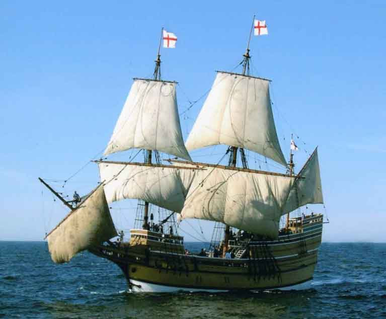
Ghost from the past. The two Mayflowers: the original took 66 days to get across the Atlantic in 1620

In fact, if you're contemplating an east-west Transatlantic voyage across the direct route on the North Atlantic in the next few weeks, for your comfort and safety we'd recommend hopping aboard a west-bound nuclear submarine. Of course, this is the negation of using solar power. But as this department of Afloat.ie has been in cahoots for a long time with that secret society which believes we're ultimately going to have to rely on nuclear power to save the planet, the entire idea seems utterly logical, and going underwater makes sense.

For it's on the interface between sea and air that boats and ships get battered about. Go silent, go deep, go smooth. Back in the day when NATO saw large fleets exercising in harmony, other navies noticed that around mid-day there seemed to be a slackening of activity among French submarines. Between 1230 hrs and 1430 hrs, you wouldn't hear a word from them at all. It seems they all gently descended to their own favoured smooth spots on the seabed, and there they sat in order to enjoy a proper French lunch – wine and all – totally undisturbed.

French Nuclear submarine of the Shortfin Barracuda Class. A descent to the peace of the seabed for an undisturbed lunch was, as they say in the Michelin Guide, "well worth the detour"French Nuclear submarine of the Shortfin Barracuda Class. A descent to the peace of the seabed for an undisturbed lunch was, as they say in the Michelin Guide, "well worth the detour".

So maybe if we want to send unmanned "ships" reliably across the Atlantic, we should be thinking under-water well below those bumpy waves, and use crew-less nuclear subs. The technology would be mind-boggling. But apparently some of the computing power being deployed for the Mayflower Autonomous Ship was originally devised to predict risks in international banking, and just look how successful that has been over the years…….

Published in News Update
Tagged under

Some sailing events capture the popular imagination, while others – for some reason – simply pass by relatively unheeded. Either way, there’s no doubting that the 628-mile Rolex Sydney-Hobart Race is in the former category, with its crazy Christmas-time start witnessed by as many as 600,000 people, watching the inevitable flotilla of over-the-top SuperMaxis weaving their way out of the superb harbour at the head of an exceptionally varied and historic fleet.

It was going to be special in this year of all years, for 75 years is a long time in terms of Euro-centric Australian history. Of course, there were people in Australia for tens of thousands of years before the Europeans arrived. But like the early pre-Spanish discoverers of the Canary Islands, those First Australians who did manage to get safely ashore – for many didn’t make it – gradually abandoned any thought of seafaring as they worked out ways of making a living entirely on land from this very strange place they’d stumbled upon.

sydney hobart race start 2019 
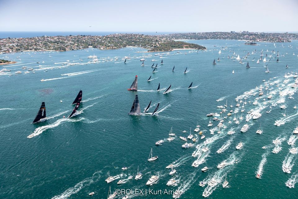
The big boats get away from the Sydney haze at the start on Thursday. Photo: Rolex/Kurt Arrigo
But for the new Australians from Europe, seafaring with its communication to the outside world was essential. Yet their distance from that world meant they developed their own ways of doing things, with the betting-mad Sydney Harbour 18-footers the ultimate sailing expression of the sports-oriented Australian way of life.

This year, the Sydney-Hobart has taken on added significance, for since August, Australia has been fighting a growing – and sometimes tragically fatal - battle with bush fires. The Lucky Country has been out of some of its luck, and it’s arguable that this loss of luck has been partly self-inflicted. But no country in the world can claim innocence in the causes of climate change, yet it’s Australia’s misfortune that the bush fires after years of drought should so markedly impinge on the Australian way of life, with its outdoor emphasis.

The Sydney-Hobart Race is a chance to show that life goes on, albeit in a wiser frame of mind. All it needed on December 26th 2019 was a decent onshore breeze to restore Sydney Harbour to its clear and sunny self, and a fleet which acknowledged that times aren’t quite normal, but life must go on.

rshr 2019 start3
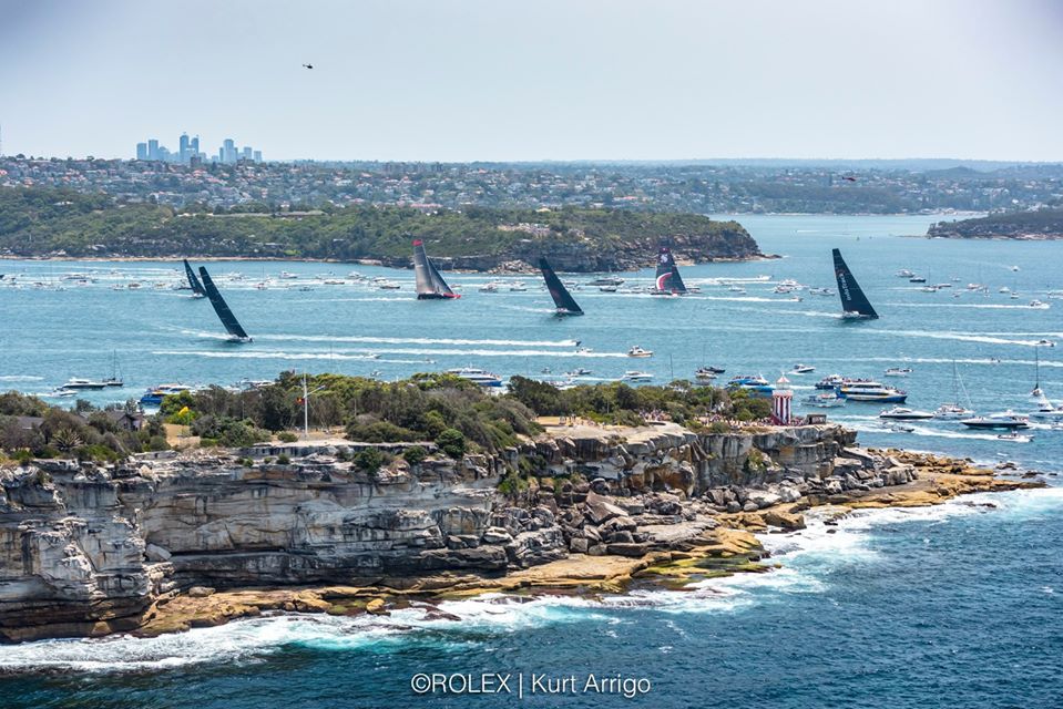
The SuperMaxis heading into open water on Thursday – the size of the spectator fleet, plus tens of thousands of watchers ashore, spoke volumes for how much the successful staging of the 75th Rolex Sydney-Hobart Race meant to Australians in these challenging times. Photo: Rolex/Kurt Arrigo
And it certainly is a life-affirming event, one of sailing’s great spectacles, yet one in which every boat in the fleet from 30 footers to 100 footers feels equally involved. Having been inaugurated in 1945 under the inspiration of that remarkable offshore racing pioneer John Illingworth, it soon seemed the most natural thing in the world to race from Sydney to Hobart, for an annual cruise-in-company along the same route was a Christmas tradition at the Cruising Yacht Club of Australia.

Today, Sydney-Hobart as a brand name has real muscle, and while Sydney has always basked in its association with the race’s start, it took the more conservative Hobart rather longer to realize that this sporting special gave them a USP in the Tasmania-promotion stakes for tourism.

hobart tasmania4
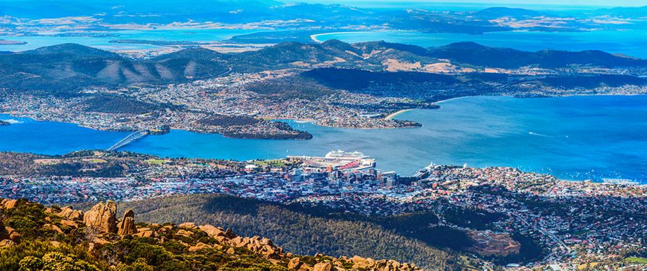
Hobart in Tasmania – it’s the same latitude as Bordeaux in France
In fact, interest is at an all-time high, for last year for the first time a Tasmanian boat was the overall winner, Philip Turner’s RP66 Alive. It’s as though a Wicklow boat had won the Round Ireland Race…… And these days, those who had thought Tasmania was a remote and windy island somewhere down towards the Antarctic are now aware that Hobart in the Southern Hemisphere is on the same latitude as Bordeaux in the Northern Hemisphere, and it’s a charming and scenically stunning place with its own remarkable classic yacht tradition.

yacht alive5
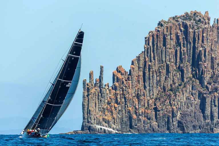
The Tasmanian RP 66 Alive weathering the famous Organ Pipes in the approaches to Hobart, on her way to the overall win in the 2018 Rolex Sydney-Hobart Race. Photo: Studio Borlenghi/Rolex
Thus the message is that if you’ve got your port associated with a great sailing event which has popular interest, for heaven’s sake do everything you can to nurture the relationship. In following the Sydney-Hobart Race’s fascinating progress with its often extraordinary yet time-honoured finish totally identified with Hobart, it’s a reminder that just a month ago, the world of offshore racing – indeed the world of sailing globally – was agog at the news that the biennial Fastnet Races of 2021 and 2023 would not finish at Plymouth in Devon - as the race had done since its inauguration in 1925 - but instead would finish in Cherbourg, where the local authorities were prepared to be lavish with their preparations and welcome.

The people of Plymouth must think the fates have got it in for them. The historic harbour, associated with the swashbuckling if sometimes very questionable wealth-enhancing seafaring deeds of the likes of Drake and Raleigh and Hawkins, has been seeing its more modern maritime links greedily challenged by other ports.

As Shakespeare observed in another context in the time of those energetic opportunists: “When sorrows come, they come not single spies, but in battalions”. For Plymouth, it was only starting when it was announced back in May that an alternative OSTAR (the original single-handed Transatlantic Race first staged from Plymouth’s Royal Western YC in 1960) was going to have a highly-funded re-birth from Brest in France.

plymouth england6
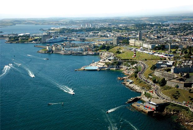
The Port of Plymouth, which has hosted the finish of every Fastnet Race since 1925. But for 2021, the finish will be in Cherbourg
That announcement didn’t come from Plymouth. It emanated from OC Sport, who have rights in the race and are based in Cowes, but have been majority French-owned since 2014. Meanwhile, Plymouth is going ahead with its own 60th Anniversary OSTAR (Original Single-Handed Race) on 10th May.

For the mega-funded hyper-publicised French super-multihulls, the offering from Brest has obvious appeal. But the historical claims of Plymouth are likewise gaining their adherents, and as entries don’t close until 16th March 2020, the evolving story of the two races is continuing.

Then in late November, with just ten days to go until December’s Paris Boat Show with its potential to give significant upcoming events a fresh buzz of publicity, it was announced that the RORC Rolex Fastnet Races of 2021 and 2023 would not be finishing in Plymouth - as the race has done since it was founded in 1925 – but instead, in a course 90 miles longer, the finish would be in facility-filled money-waving Cherbourg in France.

The reactions to this have been spread right across the entire spectrum from complete disapproval to enthusiastic support, and even now it’s still simmering.

At the apparently rather sparsely attended but online-streamed press conference in RORC HQ in London, the top honchos did reveal that for the Centenary Fastnet Race in 2025, they might consider returning to Plymouth if berthing facilities has been markedly improved.

In the circumstances, it sounded slightly patronizing with an unpleasant whiff of the wheeler-dealing about it. But we can soften their cough by pointing out that if they really want a truly authentic Centenary Fastnet Race in 2025, then they’ll have to abandon the Cowes starting line, and instead start the fleet eastward out of the Solent from the Royal Victoria Yacht Club in Ryde. Back in 1925, the big clubs at Cowes declined to get involved in this crazy new venture. But once it was clear that it was established and would happen again, it was a case of Hello Cowes, Goodbye Ryde…….

wizard fastnet7
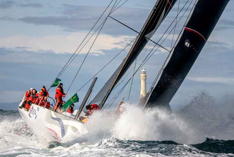
Wherever the Fastnet Race starts or finishes, it will still have to go round Ireland’s most famous rock. This is the American former Volvo 70 Wizard (David & Peter Askew), winner of World Sailing’s “Boat of the Year 2019” title, at the Fastnet Rock on her way to winning the Rolex Fastnet race 2019. Photo: Rolex 

No matter what they do, Ireland’s impregnable Fastnet Rock remains immovably at the heart of it all. It is simply The Fastnet Race – full stop. But back in Plymouth, yet another historical challenge to their cherished maritime perception of themselves arose at the end of November. For they’d been thinking that, regardless of what might happen to the OSTAR and the Fastnet Race, the really big deal in their maritime history is their link to the Pilgrim Fathers sailing in the Mayflower from Plymouth to America in 1620.

Now there’s an anniversary to conjure with. 400 years to be celebrated in Plymouth in 2020 for something which has pure gold historical importance. But the people of Harwich on England’s East Coast say that Plymouth’s claims to the Mayflower story are only incidental. The ship began her voyage from the East Coast, they say, and only called briefly at Plymouth while heading west.

To underline their case, they’ve spent 2019 restoring the house in Harwich which was the home of Christopher Jones, Captain of the Mayflower, and in 2020 they look forward to greeting thousands of American visitors to Mayflower’s most tangible and authentic link.

And to the west of Plymouth, the people of the fishing port of Newlyn in Cornwall are also claiming that the Mayflower actually stopped there - albeit briefly – before the real beginning of the Transatlantic voyage, so that’s where the American tourists should be splashing their dollars.

Quite so. It would be time for the people of Plymouth to send for Francis Drake and his more ruthless shipmates to sort this out were it not for one indisputable geographic and historical fact. The place where the Pilgrim Fathers first landed in America in December 1620 is now known as Plymouh Rock. It is in Plymouth, Massachusetts. Harwich? Newlyn? Fuggedaboudit……..

mayflower two plymouth8
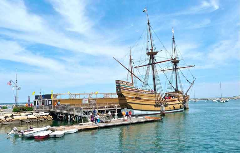
An inescapable fact of history and geography – Mayflower II berthed at Plymouth, Massachusetts. 
Meanwhile, Hobart and Tasmania have literally shaken off their links with a dismal penal colonial, past, and the place is re-born as a destination for the discerning, with a pleasant climate, fantastic scenery, and some great sailing people who can count winning the Sydney-Hobart race among their achievements. There’s no way they’re going to allow that particular link to be broken.

Published in W M Nixon
Tagged under

Members of the public will be able to see their name etched into history when ambitious plans to build a multi-million pound robot boat to mark the 400th anniversary of the sailing of the Mayflower out of Plymouth take another step forward next month.

The team behind the Mayflower Autonomous Ship are planning a Crowdfunding launch which will offer, among many other rewards, the chance to put individual names on the side of the ship when it is built.

It will be the 21st Century version of the Mayflower and be able to sail without crew from Plymouth UK to Plymouth, USA in 2020 on the 400th anniversary of the first sailing.

Last week organisers received the support of the Ambassador of the United States of America Matthew Barzun at a special reception at the Embassy in London to celebrate the transatlantic relationship.

But in order to get the design from blueprint to boatyard, organisers need to raise £300,000 for the crucial next design and development stage which will include robust wave tank scale-model testing.

Everyone is being offered the chance to get their name written into history as ‘new pilgrims' by buying a reward that will literally make their mark on the project. For £20 you can put your name on the boat; for £50 you can put your family's name on it and for £35 you can put two names and a significant date.

Larger rewards will include invitations to VIP events, invitations to the launch, exclusive opportunities and other offers.

"So far we have the plans, the passion, the potential and now all we need is to get it to production," explains Patrick Dowsett, who spent 30 years in the Royal Navy, including time as a commander, in charge of HMS Northumberland.

"It is ground-breaking in so many ways and will put Plymouth on the global map for marine science excellence. We are offering everyone a chance to get involved in this incredible Devon project.

"This first stage will nail down the planning, the testing, the project development and the modelling to enable us to start the build of the real thing in 2018."

The launch of the Mayflower Autonomous Ship out of Plymouth UK as the flagship of the Mayflower 400 celebrations will cement the city's reputation as a global centre of marine excellence and a marine science hub.

The Mayflower Autonomous Ship (MAS) will be the first vessel of its kind to sail without captain or crew across the Atlantic and be able to conduct scientific research around the world.

With driverless cars already on the horizon and the air industry using computers to fly planes, MAS could lead the way to changing the way the shipping industry works.

When launched, the MAS could be controlled by a computer, or by a captain sitting behind a virtual bridge onshore. It would sail out of Plymouth via remote control and then switch to autonomous control once out at sea.

It will be solar powered, with cutting edge battery and renewable energy capture, travelling to inhospitable parts of the world to conduct scientific research and collect data. Onboard there will be unmanned aerial vehicles plus life rafts so that it can respond to a distress call from other mariners, and be first on the scene and render assistance.

The MAS will be built in Plymouth and the South West. The team behind the project, a collaboration between Plymouth submarine builder MSubs, Plymouth University and charitable marine research foundation Promare, is looking for suitable locations.

Published in Marine Science
Tagged under

#mayflowerII – The American–based historic replica ship Mayflower II arrived at Mystic Seaport on Sunday for a restoration at the southeastern Connecticut museum's Henry B. duPont Preservation Shipyard.

The original 110 ft. overall Mayflower was the 15th century ship that transported mostly English Puritans, known today as the Pilgrims, from Plymouth, England to the New World.

There were 102 passengers and the crew on the Dutch Cargo class ship is estimated to be approximately 30 but the exact number is unknown.

The ship that first sailed in 1609 plied many routes but her most famous was from Southampton to America.

This voyage has become an iconic story in some of the earliest annals of American history, with its story of death and of survival in the harsh New World winter environment.

Restoration work will begin this month, honouring the Mayflower II's original construction and using traditional methods with the goal of restoring the ship to her original state when she arrived to Plymouth in 1957.


Published in Tall Ships
Tagged under

General Information on using Waterways Ireland inland navigations

Safety on the Water

All users of the navigations are strongly recommended to make themselves aware of safety on the water for whatever activity they are involved in and to read the advice offered by the various governing bodies and by:

The Dept. of Transport, Ireland: www.gov.ie/transport and The Maritime and Coastguard Agency, UK, The RNLI – Water Safety Ireland for information in terms of drowning prevention and water safety.

Registration of Vessels

All vessels using the Shannon Navigation, which includes the Shannon-Erne Waterways and the Erne System must be registered with Waterways Ireland. Only open undecked boats with an engine of 15 horsepower or less on the Shannon Navigation, and vessels of 10 horsepower or less on the Erne System, are exempt. Registration is free of charge.

Craft registration should be completed online at: https://www.waterwaysireland.org/online-services/craft-registration

Permits for use of the Grand and Royal Canals and the Barrow Navigation

All vessels using the Grand and Royal Canals and the Barrow Navigation must display appropriate valid Permit(s) i.e A Combined Mooring and Passage Permit (€126) and if not intending to move every five days, an Extended Mooring Permit (€152).

Permit applications should be completed online at: https://www.waterwaysireland.org/online-services/canal-permits

Passage on the Royal and Grand Canals – Dublin Area

For boat passage through the locks east of Lock 12 into / out of Dublin on either the Royal or Grand Canals, Masters are requested to contact the Waterways Ireland Eastern Regional Office (M-F 9.30am-4.30pm) on tel: +353(0)1 868 0148 or email [email protected] prior to making passage in order to plan the necessary lock-keeping assistance arrangements.

On the Grand Canal a minimum of two days notice prior to the planned passage should be given, masters should note that with the exception of pre-arranged events, a maximum of 2 boats per day will be taken through the locks, travelling either east or west.

Movements in or out of the city will be organised by prior arrangement to take place as a single movement in one day. Boaters will be facilitated to travel the system if their passage is considered to be safe by Waterways Ireland and they have the valid permit(s) for mooring and passage.

Newcomen Lifting Bridge

On the Royal Canal two weeks’ notice of bridge passage (Newcomen Lifting Bridge) is required for the pre-set lift date, and lock assistance will then also be arranged. A minimum of 2 boats is required for a bridge lift to go ahead.

Waterways Ireland Eastern Regional Office (Tel: +353(0)1 868 0148 or [email protected] ) is the point of contact for the bridge lift.

A maximum number of boats passing will be implemented to keep to the times given above for the planned lifts (16 for the Sat / Sun lifts & 8 for the weekday lifts). Priority will be given on a first come first served basis.

On day of lift, boaters and passengers must follow guidance from Waterways Ireland staff about sequence of passage under bridge & through Lock 1, and must remain within signed and designated areas.

Events Held on the Waterways

All organised events taking place on the waterways must have the prior approval of Waterways Ireland. This is a twelve week process and application forms must be accompanied with the appropriate insurance, signed indemnity and risk assessment. The application should be completed on the Waterways Ireland events page at :

https://www.waterwaysireland.org/online-services/event-approval

Time Limits on Mooring in Public Harbours

On the Shannon Navigation and the Shannon-Erne Waterway craft may berth in public harbours for five consecutive days or a total of seven days in any one month.

On the Erne System, revised Bye Laws state that: No master or owner shall permit a vessel, boat or any floating or sunken object to remain moored at or in the vicinity of any public mooring, including mooring at any other public mooring within 3 kilometres of that location, for more than 3 consecutive days and shall not moor at that same mooring or any other public mooring within 3 kilometres of that location within the following 3 consecutive days without prior permission by an authorised official.

Winter Mooring on the Shannon Navigation and Shannon Erne Waterway

Winter mooring may be availed of by owners during the period 1 Nov to 31 Mar by prior arrangement and payment of a charge of €63.50 per craft. Craft not availing of Winter Mooring must continue to comply with the “5 Day Rule”. Winter Mooring applications should be completed online at : https://www.waterwaysireland.org/online-services/winter-moorings-booking

Owners should be aware that electricity supply and water supply to public moorings is disconnected for the winter months. This is to protect against frost damage, to reduce running costs and to minimise maintenance requirements during the winter months.

Vessel owners are advised that advance purchasing of electricity on the power bollards leading up to the disconnection date should be minimal. Electricity credit existing on the bollards will not be recoverable after the winter decommissioning date. Both services will be reinstated prior to the commencement of the next boating season.

Smart Cards

Waterways Ireland smart cards are used to operate locks on the Shannon Erne Waterway, to access the service blocks, to use the pump-outs along the navigations, to avail of electrical power at Waterways Ireland jetties.

Berthing in Public Harbours

Masters are reminded of the following:

  • Equip their vessel with mooring lines of appropriate length and strength and only secure their craft to mooring bollards and cleats provided for this purpose.
  • Ensure the available berth is suitable to the length of your vessel, do not overhang the mooring especially on finger moorings on floating pontoon moorings.
  • Ensure mooring lines, electric cables and fresh water hoses do not create a trip hazard on public jetties for others users.
  • Carry sufficient fenders to prevent damage to your own vessel, other vessels and WI property.
  • Allow sufficient space between your vessel and the vessel ahead /astern (c.1m) for fire safety purposes and /or to recover somebody from the water.
  • Do not berth more than two vessels side by side and ensure there is safe access/egress at all times between vessels and onto the harbour itself.
  • Do not berth in such a way to prevent use of harbour safety ladders, slipways or pump-outs.
  • Do not allow the bow of your vessel to overhang the walkway of a floating mooring thus creating a hazard for others with an overhanging anchor or bow fendering.
  • Animals are not allowed to be loose or stray at any time.
  • Harbour and jetty infrastructure such as railings, power pedestals, fresh water taps, electric light poles, safety bollards, ladders etc are not designed for the purpose of mooring craft , they will not bear the strain of a vessel and will be damaged.
  • At Carrybridge on the Erne System, Masters of vessels are not permitted to use stern on mooring. Masters of vessels must use the mooring fingers for mooring of vessels and for embarkation / disembarkation from vessels.

Passenger Vessel Berths

Masters of vessels should not berth on passenger vessel berths where it is indicated that an arrival is imminent. Passenger vessels plying the navigations generally only occupy the berths to embark and disembark passengers and rarely remain on the berths for extended periods or overnight.

Lock Lead-in Jetties

Lead-in jetties adjacent to the upstream and downstream gates at lock chambers are solely for the purpose of craft waiting to use the lock and should not be used for long term berthing.

Vessel Wake

Vessel wake, that is, the wave generated by the passage of the boat through the water, can sometimes be large, powerful and destructive depending on the hull shape and engine power of the vessel. This wake can be detrimental to other users of the navigation when it strikes their craft or inundates the shoreline or riverbank. Masters are requested to frequently look behind and check the effect of their wake / wash particularly when passing moored vessels, on entering harbours and approaching jetties and to be aware of people pursuing other activities such as fishing on the riverbank.

Speed Restriction

A vessel or boat shall not be navigated on the Shannon Navigation at a speed in excess of 5 kph when within 200 metres of a bridge, quay, jetty or wharf, when in a harbour or canal or when passing within 100 metres of a moored vessel or boat.

Vessels navigating the Shannon-Erne Waterway should observe the general 5 kph speed limit which applies along the waterway. This is necessary in order to prevent damage to the banks caused by excessive wash from vessels.

Vessels navigating the Erne System should observe the statutory 5kt / 6mph / 10kph speed limit areas.

A craft on the Royal and Grand canals shall not be navigated at a speed in excess of 6km per hour.

A craft on the Barrow Navigation shall not be navigated at a speed in excess of 11km per hour except as necessary for safe navigation in conditions of fast flow.

Bank Erosion

Narrow sections of all the navigations are particularly prone to bank erosion due to the large wash generated by some craft. Masters are requested to be vigilant and to slow down to a speed sufficient to maintain steerage when they observe the wash of their craft inundating the river banks.

Unusual Waterborne Activity

Unusual waterborne vessels may be encountered from time to time, such as, hovercraft or amphibious aircraft / seaplanes. Masters of such craft are reminded to apply the normal “Rule of the Road” when they meet conventional craft on the water and to allow extra room to manoeuvre in the interest of safety.

Sailing Activity

Mariners will encounter large numbers of sailing dinghies from late June to August in the vicinity of Lough Derg, Lough Ree and Lower Lough Erne. Sailing courses are marked by yellow buoys to suit weather conditions on the day. Vessels should proceed at slow speed and with due caution and observe the rules of navigation when passing these fleets, as many of the participants are junior sailors under training.

Rowing

Mariners should expect to meet canoes and vessels under oars on any part of the navigations, but more so in the vicinity of Athlone, Carrick-on-Shannon, Coleraine, Enniskillen and Limerick. Masters are reminded to proceed at slow speed and especially to reduce their wash to a minimum when passing these craft as they can be easily upset and swamped due to their very low freeboard and always be prepared to give way in any given traffic situation.

Canoeing

Canoeing is an adventure sport and participants are strongly recommended to seek the advice of the sport’s governing bodies i.e Canoeing Ireland and the Canoe Association of Northern Ireland, before venturing onto the navigations.

Persons in charge of canoes are reminded of the inherent danger to these craft associated with operating close to weirs, sluice gates, locks and other infrastructure particularly when rivers are in flood and large volumes of water are moving through the navigations due to general flood conditions or very heavy localised precipitation e.g. turbulent and broken water, stopper waves. Shooting weirs is prohibited without prior permission of Waterways Ireland.

Canoeists should check with lockkeepers prior entering a lock to ensure passage is done in a safe manner. Portage is required at all unmanned locks.

Canoe Trail Network – "Blueways"

Masters of powered craft are reminded that a canoe trail network is being developed across all navigations and to expect more organised canoeing along these trails necessitating slow speed and minimum wash when encountering canoeists, rowing boats etc

Rockingham and Drummans Island Canals – Lough Key

It is expected that work on Rockingham and Drummans Island Canals on Lough Key will be completed in 2021. Access to these canals will be for non-powered craft only, eg canoes, kayaks, rowing boats.

Fast Powerboats and Personal Watercraft (Jet Skis)

Masters of Fast Powerboats (speed greater than 17kts) and Personal Watercraft (i.e.Jet Skis) are reminded of the inherent dangers associated with high speed on the water and especially in the confines of small bays and narrow sections of the navigations. Keeping a proper look-out, making early alterations to course and /or reducing speed will avoid conflict with slower vessels using the navigation. Personal Watercraft are not permitted to be used on the canals.

Towing Waterskiers, Wakeboarders, Doughnuts etc

Masters of vessels engaged in any of these activities are reminded of the manoeuvring constraints imposed upon their vessel by the tow and of the added responsibilities that they have to the person(s) being towed. These activities should be conducted in areas which are clear of conflicting traffic. It is highly recommended that a person additional to the master be carried to act as a “look-out” to keep the tow under observation at all times.

Prohibition on Swimming

Swimming in the navigable channel, particularly at bridges, is dangerous and is prohibited due to the risk of being run over by a vessel underway in the navigation.

Age Restrictions on operating of powered craft

In the Republic of Ireland, Statutory Instrument 921 of 2005 provides the legal requirements regarding the minimum age for operating of powered craft. The Statutory Instrument contains the following requirements:

- The master or owner of a personal watercraft or a fast power craft shall take all reasonable steps to ensure that a person who has not attained the age of 16 years does not operate or control the craft

- The master or owner of a pleasure craft powered by an engine with a rating of more than 5 horse power or 3.7 kilowatts shall take all reasonable steps to ensure that a person who has not attained the age of 12 years does not operate or control the craft.

Lifejackets and Personal Flotation Devices (PFDs)

Lifejackets and PFD’s are the single most important items of personal protective equipment to be used on a vessel and should be worn especially when the vessel is being manoeuvred such as entering / departing a lock, anchoring, coming alongside or departing a jetty or quayside.

In the Republic of Ireland, Statutory Instrument 921 of 2005 provides the legal requirements regarding the wearing of Personal Flotation Devices. The Statutory Instrument contains the following requirements:

- The master or owner of a pleasure craft (other than a personal watercraft) shall ensure, that there are, at all times on board the craft, sufficient suitable personal flotation devices for each person on board.

- A person on a pleasure craft (other than a personal watercraft) of less than 7 metres length overall shall wear a suitable personal flotation device while on board an open craft or while on the deck of decked craft, other than when the craft is made fast to the shore or at anchor.

- The master or owner of a pleasure craft (other than a personal watercraft) shall take all reasonable steps to ensure that a person who has not attained the age of 16 years complies with paragraph above.

- The master or owner of a pleasure craft (other than a personal watercraft), shall take all reasonable steps to ensure that a person who has not attained the age of 16 years wears a suitable personal flotation device while on board an open craft or while on the deck of a decked craft other than when it is made fast to the shore or at anchor.

- The master or owner of a pleasure craft (other than a personal watercraft) shall take all reasonable steps to ensure that a person wears a suitable personal flotation device, at all times while – (a) being towed by the craft, (b) on board a vessel or object of any kind which is being towed by the craft.

Further information is available at: http://www.irishstatutebook.ie/eli/2005/si/921/made/en/print

Firing Range Danger Area – Lough Ree

The attention of mariners is drawn to the Irish Defence Forces Firing Range situated in the vicinity of buoys No’s 2 and 3, on Lough Ree on the Shannon Navigation. This range is used regularly for live firing exercises, throughout the year, all boats and vessels should stay clear of the area marked with yellow buoys showing a yellow "X" topmark and displaying the word "Danger".

Shannon Navigation, Portumna Swing Bridge Tolls

No attempt should be made by Masters’ of vessels to pay the bridge toll while making way through the bridge opening. Payment will only be taken by the Collector from Masters when they are secured alongside the jetties north and south of the bridge.

Navigating from Killaloe to Limerick on the Shannon Navigation

The navigation from Killaloe to Limerick involves passage through Ardnacrusha locks, the associated headrace and tailrace and the Abbey River into Limerick City. Careful passage planning is required to undertake this voyage. Considerations include: lock passage at Ardnacrusha, water flow in the navigation, airdraft under bridges on Abbey River in Limerick, state of tide in Limerick

Users are advised to contact the ESB Ardnacrusha hydroelectric power station (00353 (0)87 9970131) 48 hours in advance of commencing their journey to book passage through the locks at Ardnacrusha. It is NOT advised to undertake a voyage if more than one turbine is operating (20MW), due to the increased velocity of flow in the navigation channel, which can be dangerous. To ascertain automatically in real time how many turbines are running, users can phone +353 (0)87 6477229.

For safety reasons the ESB has advised that only powered craft with a capacity in excess of 5 knots are allowed to enter Ardnacrusha Headrace and Tailrace Canals.

Passage through Sarsfield Lock should be booked on +353-87-7972998, on the day prior to travel and it should be noted also that transit is not possible two hours either side of low water.

A Hydrographic survey in 2020 of the navigation channel revealed that the approach from Shannon Bridge to Sarsfield Lock and the Dock area has silted up. Masters of vessels and water users are advised to navigate to the Lock from Shannon bridge on a rising tide one or two hours before High Tide.

Lower Bann Navigation

The attention of all users is drawn to the “Users Code for the Lower Bann”, in particular to that section covering “Flow in the River” outlining the dangers for users both on the banks and in the navigation, associated with high flow rates when the river is in spate. Canoeists should consult and carry a copy of the “Lower Bann Canoe Trail” guide issued by the Canoe Association of Northern Ireland. Users should also contact the DfI Rivers Coleraine, who is responsible for regulating the flow rates on the river, for advisory information on the flow rates to be expected on any given day.

DfI Rivers Coleraine. Tel: 0044 28 7034 2357 Email: [email protected]

Lower Bann Navigation – Newferry – No wake zone

A No Wake Zone exists on the Lower Bann Navigation at Newferry. Masters of vessels are requested to proceed at a slow speed and create no wake while passing the jetties and slipways at Newferry.

Overhead Power Lines (OHPL) and Air draft

All Masters must be aware of the dangers associated with overhead power lines, in particular sailing vessels and workboats with cranes or large air drafts. Voyage planning is a necessity in order to identify the location of overhead lines crossing the navigation.

Overhead power line heights on the River Shannon are maintained at 12.6metres (40 feet) from Normal Summer level for that section of navigation, masters of vessels with a large air draft should proceed with caution and make additional allowances when water levels are high.

If a vessel or its equipment comes into contact with an OHPL the operator should NOT attempt to move the vessel or equipment. The conductor may still be alive or re-energise automatically. Maintain a safe distance and prevent third parties from approaching due to risk of arcing. Contact the emergency services for assistance.

Anglers are also reminded that a minimum ground distance of 30 metres should be maintained from overhead power lines when using a rod and line.

Submarine Cables and Pipes

Masters of vessels are reminded not to anchor their vessels in the vicinity of submarine cables or pipes in case they foul their anchor or damage the cables or pipes. Look to the river banks for signage indicating their presence.

Water Levels - Precautions

Low Water Levels:

When water levels fall below normal summer levels masters should be aware of:

Navigation

To reduce the risk of grounding masters should navigate on or near the centreline of the channel, avoid short cutting in dog-legged channels and navigating too close to navigation markers.

Proceeding at a slow speed will also reduce “squat” effect i.e. where the vessel tends to sit lower in the water as a consequence of higher speed.

Slipways

Reduced slipway length available under the water surface and the possibility of launching trailers dropping off the end of the concrete apron.

More slipway surface susceptible to weed growth requiring care while engaged in launching boats, from slipping and sliding on the slope. Note also that launching vehicles may not be able to get sufficient traction on the slipway once the craft is launched to get up the incline.

Bank Erosion

Very dry riverbanks are more susceptible to erosion from vessel wash.

Lock Share

Maximising on the number of vessels in a lock will ensure that the total volume of water moving downstream is decreased. Lock cycles should be used for vessels travelling each way.

High Water Levels:

When water levels rise above normal summer level masters should be aware of:

Navigation

Navigation marks will have reduced height above the water level or may disappear underwater altogether making the navigable channel difficult to discern.

In narrow sections of the navigations water levels will tend to rise more quickly than in main streams and air draft at bridges will likewise be reduced.

There will also be increased flow rates particularly in the vicinity of navigation infrastructure such as bridges, weirs, locks etc where extra care in manoeuvring vessels will be required.

Harbours and Jetties

Due care is required in harbours and at slipways when levels are at or near the same level as the harbour walkways' as the edge will be difficult to discern especially in reduced light conditions. It is advised that Personal Flotation Devices be worn if tending to craft in a harbour in these conditions.

Slipways

Slipways should only be used for the purpose of launching and recovering of water craft or other objects from the water. Before using a slipway it should be examined to ensure that the surface has sufficient traction/grip for the intended purpose such as launching a craft from a trailer using a vehicle, that there is sufficient depth of water on the slipway to float the craft off the trailer before the concrete apron ends and that the wheels of the trailer do not drop off the edge of the slipway. That life-saving appliances are available in the vicinity, that the vehicle is roadworthy and capable of coping with the weight of the trailer and boat on the incline. It is recommended that slipway operations are conducted by two persons.

Caution to be Used in Reliance upon Aids to Navigation

The aids to navigation depicted on the navigation guides comprise a system of fixed and floating aids to navigation. Prudent mariners will not rely solely on any single aid to navigation, particularly a floating aid to navigation. With respect to buoys, the buoy symbol is used to indicate the approximate position of the buoy body and the ground tackle which secures it to the lake or river bed. The approximate position is used because of the practical limitations in positioning and maintaining buoys in precise geographical locations. These limitations include, but are not limited to, prevailing atmospheric and lake/river conditions, the slope of and the material making up the lake/river bed, the fact that the buoys are moored to varying lengths of chain, and the fact that the buoy body and/or ground tackle positions are not under continuous surveillance. Due to the forces of nature, the position of the buoy body can be expected to shift inside and outside the charted symbol.

Buoys and perches are also moved out of position or pulled over by those mariners who use them to moor up to instead of anchoring. To this end, mariners should always monitor their passage by relating buoy/perch positions with the published navigation guide. Furthermore, a vessel attempting to pass close by always risks collision with a yawing buoy or with the obstruction that the buoy or beacon/perch marks.

Masters of Vessels are requested to use the most up to date Navigation guides when navigating on the Inland Waterways.

Information taken from Special Marine Notice No 1 of 2023