Menu

Ireland's sailing, boating & maritime magazine

Inland afloat headers


Displaying items by tag: Mediterranean

#NormanAtlantic - RTÉ News reports that Italy has launched a criminal investigation into the blaze on the car ferry Norman Atlantic as the Greek government confirms the recovery of four bodies from the site of the disaster off Corfu.

As reported yesterday on Afloat.ie, the ferry sailing the Mediterranean from Greece to Italy called for help after a fire broke out in its lower decks.

Prosecutors will determine whether negligence played a role in the incident as rescue teams continue to battle the elements to evacuate more than 100 passengers who remain on the vessel.

The Guardian says four British nationals are among those rescued so far.

Meanwhile, according to The Irish Times, language difficulties between the crew of the Italian-registered ferry and its predominantly Greek passengers have posed problems on board.

Published in News Update

#Rescue - Some 466 people were being evacuated this morning from a car ferry that reported a fire on board while sailing from Greece to Italy this morning, according to RTÉ News.

As of 8am this morning Irish time, 130 people had been moved from the Norman Atlantic via a rescue boat to a nearby container ship some 44 nautical miles west of Corfu.

Passengers have described a lack of co-ordination in the evacuation effort since the fire broke out at 4am Irish time.

"They tried to lower some boats, but not all of us could get in," one person claiming to be a passenger told a Greek TV station by phone.

And as The Irish Times reports, poor weather in the area - with wind speeds of up to 88km per hour - has made the rescue effort "complicated".

“We are doing everything we can to save those on board and no one, no one will be left helpless in this tough situation,” said Greek shipping minister Miltiadis Varvitsiotis.

The incident comes almost three years after the wrecking of the Costa Concordia in the waters off western Italy.

RTÉ News has more on this developing story HERE.

Published in Rescue
Tagged under
#VOLVO OCEAN RACE - Abu Dhabi Ocean Racing's challenge was nearly scuppered at the outset when their yacht suffered a broken mast just hours into the first leg of the Volvo Ocean Race yesterday.
The accident occurred 30 nautical miles south of Cartagena on the Spanish Mediterranean, when the yacht Azzam encountered rough weather some six hours after leaving Alicante.
"Our mast broke into three pieces when landing off a big wave in 30+ knots of wind," said skipper Ian Walker. "We were sailing under a J4 and two reefs. We do not as yet know the cause."
The broken mast pieces and rig were recovered, thanks to the "courageous" intervention of crewman Wade Morgan, who entered the water to cut away the top of the mainsail.
Walker added: “The mast from the first spreader up is now secured to the port side of the boat. About three or four metres protrude from behind the boat. A spider web of lines is keeping the operation intact. The crew are deeply disappointed.”
Yacht and crew - which includes Wexford man Justin Slattery - were last night headed towards the flatter water at Cabo de Palos before returning to Alicante under motor to begin repairs and get back in the race.
Abu Dhabi Ocean Racing are one of six teams competing in the epic round-the-world yacht race, which is set to finish in Galway next July.
Earlier this week the team finished first in the initial in-port race of the competition.
The official Volvo Ocean Race website has more on the story HERE.

#VOLVO OCEAN RACE - Abu Dhabi Ocean Racing's challenge was nearly scuppered at the outset when their yacht suffered a broken mast just hours into the first leg of the Volvo Ocean Race yesterday. Dismast photos by Paul Todd below.

The accident occurred 30 nautical miles south of Cartagena on the Spanish Mediterranean, when the yacht Azzam encountered rough weather some six hours after leaving Alicante.

"Our mast broke into three pieces when landing off a big wave in 30+ knots of wind," said skipper Ian Walker. "We were sailing under a J4 and two reefs. We do not as yet know the cause."


VOR2abudhabi

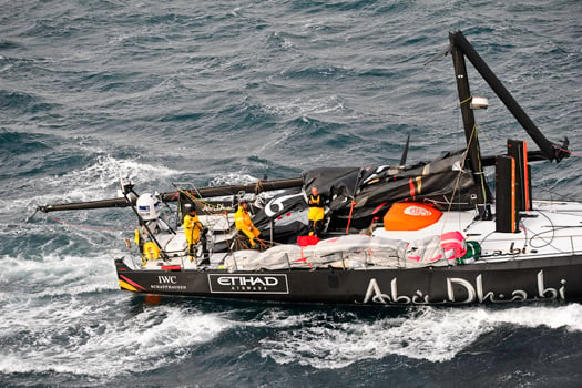
A first leg disaster for Ian Walker on Abu Dhabi - Photo: Paul Todd

The broken mast pieces and rig were recovered, thanks to the "courageous" intervention of crewman Wade Morgan, who entered the water to cut away the top of the mainsail.

Walker added: “The mast from the first spreader up is now secured to the port side of the boat. About three or four metres protrude from behind the boat. A spider web of lines is keeping the operation intact. The crew are deeply disappointed.”

Yacht and crew - which includes Wexford man Justin Slattery - were last night headed towards the flatter water at Cabo de Palos before returning to Alicante under motor to begin repairs and get back in the race.

Abu Dhabi Ocean Racing are one of six teams competing in the epic round-the-world yacht race, which is set to finish in Galway next July.

Earlier this week the team finished first in the initial in-port race of the competition.

The official Volvo Ocean Race website has more on the story HERE.

Published in Ocean Race
#VOLVO OCEAN RACE - Organisers for next year's Volvo Ocean Race stopover in Galway have promised the event will be "bigger and better" than the previous race visit in 2009.
John Killeen, president of Let's Do It Galway, told the Galway Independent that he expects as many as 8,000 foreign visitors to the City of the Tribes next July.
Killeen is in Alicante on the Spanish Mediterranean for the week of events and in-port races leading up to the official start of the 2011-12 Volvo Ocean Race this Saturday.
The race is set to finish in Galway on Tuesday 3 July 2012, attracting the world's media to Ireland's fifth largest city for the final prize-giving.
Nimmo's Pier will be the focus of entertainment facilities for the many thousands expected to throng the city as the six competing yachts complete their epic challenge
"It’s a rare opportunity for Galway and Ireland to have the leverage of such an event and, if we don’t [use it to benefit Galway], it will be remissible,” said Killeen.
The Galway Independent has more on the story HERE.

#VOLVO OCEAN RACE - Organisers for next year's Volvo Ocean Race stopover in Galway have promised the event will be "bigger and better" than the previous race visit in 2009.

John Killeen, president of Let's Do It Galway, told the Galway Independent that he expects as many as 8,000 foreign visitors to the City of the Tribes next July.

dragonberthedinAlicante

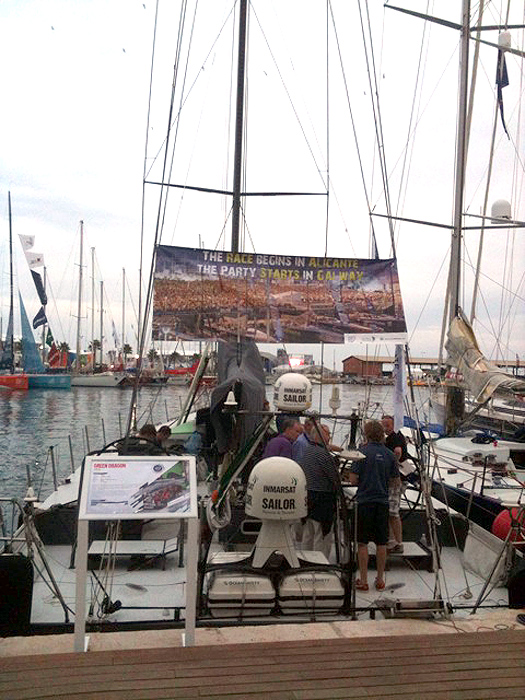
Green Dragon on show in Alicante this week – her dockside poster reads: 'the race begins in Alicante, the party starts in Galway'

Killeen is in Alicante on the Spanish Mediterranean for the week of events and in-port races leading up to the official start of the 2011-12 Volvo Ocean Race this Saturday.

The race is set to finish in Galway on Tuesday 3 July 2012, attracting the world's media to Ireland's fifth largest city for the final prize-giving.

Nimmo's Pier will be the focus of entertainment facilities for the many thousands expected to throng the city as the six competing yachts complete their epic challenge.

"It’s a rare opportunity for Galway and Ireland to have the leverage of such an event and, if we don’t [use it to benefit Galway], it will be remissible,” said Killeen.

The Galway Independent has more on the story HERE.

Published in Ocean Race

Every year, at the Cruising Association's London headquarters in Limehouse, it holds a one-day seminar for those planning to cruise in the Mediterranean. Open to both members and non-members, this year's event was a sell-out with more than 90 cruising sailors taking part. To cater for the growing demand for this type of event, the Med Section is considering running two seminars a year, with a second at another venue, in late autumn.

At this year's seminar, experts from the Cruising Association's membership led sessions on:

Eco-friendly cruising: avoiding anchoring damage, reducing and recycling waste, minimising harm from grey and black water discharges, which paints and cleaners to use on hulls and decks, and preventing pollution from engines.

Albania: a new cruising destination; ports of entry, paperwork, personal security, chart accuracy, safe anchorages, restricted areas, marinas – few and small at the moment.

Healthcare: insurance, the European healthcare scheme, prescription and over-the-counter drugs, European names for UK drugs, first-aid box contents, on-board injuries, gastric problems, sunburn, dehydration, heat stroke, insects, jelly fish, and more.

Weather: typical weather patterns, national forecasts, internet forecasts, different weather models, GRIBs, Navtex, how to interpret and evaluate forecasts, forecasting from your own observations.

Regulations: boat papers, radio licences, insurance, crew lists, passports and visas, International Certificate of Competence, CEVNI, VAT, pollution control, residency, personal taxation.
Fitting-out: awnings and biminis, drinking water, swimming, scuba and snorkels, gas, refrigeration, wind and solar generation, anchoring – rodes, scope and anchor types, bow-to and stern-to mooring, tenders, passerelles, tools and spares.

At the end of the day, delegates were asked to suggest their own tactics and techniques to improve Mediterranean cruising. Many of these involved alcohol, but the prize for the best suggestion was to anchor from the stern, to encourage airflow through the boat.

Each year, the Med Section publishes a summary of members' cruising plans to make it easier for members to arrange to meet up during the summer. The Section is organising a rally on the island of Uglyan in Croatia in June this year, and a rally in the Peloponnese is planned for 2012.

Membership of the Med Section is free to any member of the Cruising Association.

Published in Cruising
Marine surveyors are currently inspecting the German cargo ship which was refloated yesterday in Galway Bay after running aground early on Thursday.
The Irish Coast Guard confirmed to The Irish Times that no pollution had occurred in the grounding of the Pantanal on the south Connemara coast.
The 120m vessel was refloated at high tide yesterday morning with help from the Celtic Isle tug from Foynes in Co Limerick.
Ship managers Harren & Partner said the hull would undergo a diver inspection before the vessel sails for dry dock.
Yesterday Minister for the Marine Simon Coveney welcomed the "successful operation in very challenging conditions" and confirmed a thorough investigation of the incident by the Marine Casualty Investigation Board.
The ship had been sailing from the Mediterranean to Rossaveal to collect two monohull ferries, sold to Mauritius, that had been built to serve the Aran Islands route.
The Irish Times has more on the story HERE.

Marine surveyors are currently inspecting the German cargo ship which was refloated yesterday in Galway Bay after running aground early on Thursday.

The Irish Coast Guard confirmed to The Irish Times that no pollution had occurred in the grounding of the Pantanal on the south Connemara coast.

The 120m vessel was refloated at high tide yesterday morning with help from the Celtic Isle tug from Foynes in Co Limerick.

Ship managers Harren & Partner said the hull would undergo a diver inspection before the vessel sails for dry dock.

Yesterday Minister for the Marine Simon Coveney welcomed the "successful operation in very challenging conditions" and confirmed a thorough investigation of the incident by the Marine Casualty Investigation Board.

The ship had been sailing from the Mediterranean to Rossaveal to collect two monohull ferries, sold to Mauritius, that had been built to serve the Aran Islands route.

The Irish Times has more on the story HERE.

Published in Ports & Shipping

The Cruising Association has just launched a new internet and email based net, which lets members cruising various regions of the world arrange meets, ask questions and receive answers about ever-changing local facilities and regulations.

It all started in 2000 as Mednet, a service for some 85 members cruising yachts and motorboats in the Mediterranean. MedNet 1 allowed one-to-one email communication but soon members wanted more, especially the ability to see the answers to other members' questions.

So MedNet 2 was born in Spring 2001, providing wider access to conversations. By Autumn 2003 MedNet 2 had moved to Yahoo Groups, but as membership increased mail traffic became too heavy for slow and expensive internet connections on boats. As a consequence MedNetLite was introduced for those with low bandwidth connections. By now 250 users were exchanging news about lay-up sites, marinas, restaurants, anchorages, provisioning, boatyards, itineraries and regulatory changes. But a good long-term record of all this data was missing.

So MedNet 3 was introduced in 2006, working as an email based forum within MyCA, the Cruising Association members-only intranet. There were still shortcomings. The system was passive, collecting e-mails and displaying them online. Inputs were only by email. By now, users had grown to 350, 10% of the Cruising Association's membership. Members cruising in other regions began asking for their own networks.

The time had come to upgrade so Version 4 was developed by a group of Cruising Association members with IT skills. This has just been launched for four regions; Mediterranean, Baltic, European Inland Waterways and 'Blue Water'. Members can join as many as they wish. They post and respond online, or by email. They can receive full or lite email messages or opt for no email, just tuning in online when they have Internet access. A full record of all these discussions is maintained online, making it easy to research topics and keep the Cruising Association's many members-only publications right up-to-date.

On MedNet recent discussions have included:
• The need for grey water holding tanks in Turkey
• The cheapest way of making cash withdrawals
• Marina costs in western Italy
• Recommendations for a rigger in Preveza
• How to watch British TV in the Med
• Places for winter storage ashore
It will be interesting to see the sorts of topics that the wider use of MedNet technology brings!

Published in Cruising

Flying into Malta it's hard not to be struck by the landscape: the buildings all a blinding beige in the hot sun, the landscape fairly arid and dry. It's more reminiscent of the Northern African coast, which is only 155 nautical miles west. The island archipelago is at the crossroads of the Mediterranean situated, as it is, midway between Sicily and the coast of Tunisia. This year's fleet reflects that more than any year past, with numerous entries from throughout Europe, Russia, the United Kingdom and the United States.

One Irish boat, Legally Brunette, from Dun Laoghaire is entered in to the race.

This 31st edition of the 606-nautical mile Rolex Middle Sea Race begins this Saturday, 23 October from Grand Harbour. Registration closes on Friday, but by press time there were 83 boats entered from 18 countries. Included in this number and back to defend, are 2009 Overall Winner, Andres Soriano on the 21-metre mini-maxi Alegre (GBR), and Line Honours winner, Mike Slade on the 30.5-metre ICAP Leopard (GBR).

The race is organized and hosted by the Royal Malta Yacht Club, which moved into stylish brand new quarters overlooking Marsamxett Harbour, just prior to last year's race. The yacht club, with as rich and varied a history as this island republic, is one of the most hospitable anywhere and provides all sailors who make the effort to trek here, a warm welcome.

Yesterday, a low pressure system that swept through south of Sicily, with winds of 50 knots and 3 to 4 metre seas, which has delayed the arrival of some of the foreign fleet. Though some like Esimit Europa 2 (SLO) and Wild Joe (HUN) were already committed to crossing and so endured the conditions encountered enroute. The 30-metre Esimit had a lightening strike that took out the wind instruments at the top of its 44-metre mast. Meanwhile, Marton Jozsa's Wild Joe, a R/P Custom 60, which set out from Croatia on Friday, and then from Sicily yesterday morning, had a tough crossing, ripping both their mainsail and jib.

Many of the fleet is moored in Camper & Nicholson's Grand Harbour Marina and dockside there today there was a flurry of activity with crews effecting repairs or otherwise prepping for Saturday's offshore race. Tomorrow, Wednesday, there will be Coastal Race most likely around neighboring Comino Island. Some boats, though not all, use this race as a tune-up for the offshore.

Along the quay, there were country flags on the back of boats from Spain, Italy, Hungary, Slovenia, the UK and United States, as well as a local fleet of competitors from Malta. One would think the Maltese might have an edge – local knowledge of the area, perhaps – and in that group one of the ringers may well be Jaru (MLT), a J/133 co-skippered by John Ripard Jr. and his brother-in-law, Andrew Calascione. The close relations don't stop there, as half the crew are composed of their children, with a few close friends from the UK there to round out the crew.

Sailing onboard, as helmsman and watch leader, is 23-year old, Sebastian Ripard. This youngest of the Ripard generation is taking time out from his, and team mate Benji Borg's, campaign in the 49er class for the 2012/2016 Olympics. This 600+ mile race requires switching gears from 'around the cans'. Asked what he likes about this, his eighth, race, Sebastian said, "It's a beautiful race. I mean one of the marks is a volcano, which is often erupting! There's always a bit of everything in this race, tactically there are a lot of different points where the race compresses, so there's a lot of tricky areas: the Straits (of Messina), Stromboli, by Favignana, which make it challenging throughout. There are a lot of variables that keep on changing. And I quite enjoy the mental demands of an offshore race; it's more of an adventure. In his first go round in 2002, he racked up an overall win on the J/109 Jammin' (MLT) with – same as this year – his father and uncle. He followed that with a 2nd place in the J/109 Artie (MLT) with Lee Sartariano.

The J-Boat has a good track record for the race: a J/133 won its' class and placed 2nd overall in the 2008 Rolex Middle Sea Race. The 43-footer was Sailing World magazines' "Boat of the Year" award when it was launched in 2003 and the design has proven itself for performance cruising and offshore racing.

Almost all foreign competitors seem drawn to this unique race: a long offshore, anti-clockwise around Sicily, a few volcanoes, and some neighboring islands. Bryon Ehrhart owner and skipper of Lucky (USA), is one of those. Ehrhart, from Chicago, first raced the boat in the 2006 Newport Bermuda Race. Since then they have competed in the 2007 Transpac Race, the 2008 Chicago Mackinac, and the 2009 Rolex Fastnet Race.

His crew are a group of strong amateurs, with a few professionals that have sailed together for years. For the most part, they are Etchells (one-design) sailors, and plan to bring that level of intensity and competitiveness from the small boat fleet to a big boat offshore program.

Ehrhart said, "We have an interest in doing the truly great ocean races and certainly the Rolex Middle Sea Race is one of them. It's a race that I have read about over the years and have thought that – because of the course – would be strategically and tactically challenging, maybe even the most challenging we have done or will ever do.

"A fantastic amount of preparation has gone into getting the boat ready for this race and we hope we are up to all that we may encounter. We have converted this TP52 to an IRC offshore boat. We do a couple of big events a year and this race is the only offshore event we are doing in 2010: it is a race of the quality that is worth organizing our year around. "

Thursday is a Crew Party at the Royal Malta Yacht Club, and on Friday there will be Skipper's race and weather briefing. The Rolex Middle Sea Race commences on Saturday, 23 October 2010. The final prize giving is on Saturday, 30 October. George David's Rambler (USA) established the current Course Record of 47 hours, 55 minutes, and 3 seconds in 2007.

Published in Offshore
Page 2 of 2

General Information on using Waterways Ireland inland navigations

Safety on the Water

All users of the navigations are strongly recommended to make themselves aware of safety on the water for whatever activity they are involved in and to read the advice offered by the various governing bodies and by:

The Dept. of Transport, Ireland: www.gov.ie/transport and The Maritime and Coastguard Agency, UK, The RNLI – Water Safety Ireland for information in terms of drowning prevention and water safety.

Registration of Vessels

All vessels using the Shannon Navigation, which includes the Shannon-Erne Waterways and the Erne System must be registered with Waterways Ireland. Only open undecked boats with an engine of 15 horsepower or less on the Shannon Navigation, and vessels of 10 horsepower or less on the Erne System, are exempt. Registration is free of charge.

Craft registration should be completed online at: https://www.waterwaysireland.org/online-services/craft-registration

Permits for use of the Grand and Royal Canals and the Barrow Navigation

All vessels using the Grand and Royal Canals and the Barrow Navigation must display appropriate valid Permit(s) i.e A Combined Mooring and Passage Permit (€126) and if not intending to move every five days, an Extended Mooring Permit (€152).

Permit applications should be completed online at: https://www.waterwaysireland.org/online-services/canal-permits

Passage on the Royal and Grand Canals – Dublin Area

For boat passage through the locks east of Lock 12 into / out of Dublin on either the Royal or Grand Canals, Masters are requested to contact the Waterways Ireland Eastern Regional Office (M-F 9.30am-4.30pm) on tel: +353(0)1 868 0148 or email [email protected] prior to making passage in order to plan the necessary lock-keeping assistance arrangements.

On the Grand Canal a minimum of two days notice prior to the planned passage should be given, masters should note that with the exception of pre-arranged events, a maximum of 2 boats per day will be taken through the locks, travelling either east or west.

Movements in or out of the city will be organised by prior arrangement to take place as a single movement in one day. Boaters will be facilitated to travel the system if their passage is considered to be safe by Waterways Ireland and they have the valid permit(s) for mooring and passage.

Newcomen Lifting Bridge

On the Royal Canal two weeks’ notice of bridge passage (Newcomen Lifting Bridge) is required for the pre-set lift date, and lock assistance will then also be arranged. A minimum of 2 boats is required for a bridge lift to go ahead.

Waterways Ireland Eastern Regional Office (Tel: +353(0)1 868 0148 or [email protected] ) is the point of contact for the bridge lift.

A maximum number of boats passing will be implemented to keep to the times given above for the planned lifts (16 for the Sat / Sun lifts & 8 for the weekday lifts). Priority will be given on a first come first served basis.

On day of lift, boaters and passengers must follow guidance from Waterways Ireland staff about sequence of passage under bridge & through Lock 1, and must remain within signed and designated areas.

Events Held on the Waterways

All organised events taking place on the waterways must have the prior approval of Waterways Ireland. This is a twelve week process and application forms must be accompanied with the appropriate insurance, signed indemnity and risk assessment. The application should be completed on the Waterways Ireland events page at :

https://www.waterwaysireland.org/online-services/event-approval

Time Limits on Mooring in Public Harbours

On the Shannon Navigation and the Shannon-Erne Waterway craft may berth in public harbours for five consecutive days or a total of seven days in any one month.

On the Erne System, revised Bye Laws state that: No master or owner shall permit a vessel, boat or any floating or sunken object to remain moored at or in the vicinity of any public mooring, including mooring at any other public mooring within 3 kilometres of that location, for more than 3 consecutive days and shall not moor at that same mooring or any other public mooring within 3 kilometres of that location within the following 3 consecutive days without prior permission by an authorised official.

Winter Mooring on the Shannon Navigation and Shannon Erne Waterway

Winter mooring may be availed of by owners during the period 1 Nov to 31 Mar by prior arrangement and payment of a charge of €63.50 per craft. Craft not availing of Winter Mooring must continue to comply with the “5 Day Rule”. Winter Mooring applications should be completed online at : https://www.waterwaysireland.org/online-services/winter-moorings-booking

Owners should be aware that electricity supply and water supply to public moorings is disconnected for the winter months. This is to protect against frost damage, to reduce running costs and to minimise maintenance requirements during the winter months.

Vessel owners are advised that advance purchasing of electricity on the power bollards leading up to the disconnection date should be minimal. Electricity credit existing on the bollards will not be recoverable after the winter decommissioning date. Both services will be reinstated prior to the commencement of the next boating season.

Smart Cards

Waterways Ireland smart cards are used to operate locks on the Shannon Erne Waterway, to access the service blocks, to use the pump-outs along the navigations, to avail of electrical power at Waterways Ireland jetties.

Berthing in Public Harbours

Masters are reminded of the following:

  • Equip their vessel with mooring lines of appropriate length and strength and only secure their craft to mooring bollards and cleats provided for this purpose.
  • Ensure the available berth is suitable to the length of your vessel, do not overhang the mooring especially on finger moorings on floating pontoon moorings.
  • Ensure mooring lines, electric cables and fresh water hoses do not create a trip hazard on public jetties for others users.
  • Carry sufficient fenders to prevent damage to your own vessel, other vessels and WI property.
  • Allow sufficient space between your vessel and the vessel ahead /astern (c.1m) for fire safety purposes and /or to recover somebody from the water.
  • Do not berth more than two vessels side by side and ensure there is safe access/egress at all times between vessels and onto the harbour itself.
  • Do not berth in such a way to prevent use of harbour safety ladders, slipways or pump-outs.
  • Do not allow the bow of your vessel to overhang the walkway of a floating mooring thus creating a hazard for others with an overhanging anchor or bow fendering.
  • Animals are not allowed to be loose or stray at any time.
  • Harbour and jetty infrastructure such as railings, power pedestals, fresh water taps, electric light poles, safety bollards, ladders etc are not designed for the purpose of mooring craft , they will not bear the strain of a vessel and will be damaged.
  • At Carrybridge on the Erne System, Masters of vessels are not permitted to use stern on mooring. Masters of vessels must use the mooring fingers for mooring of vessels and for embarkation / disembarkation from vessels.

Passenger Vessel Berths

Masters of vessels should not berth on passenger vessel berths where it is indicated that an arrival is imminent. Passenger vessels plying the navigations generally only occupy the berths to embark and disembark passengers and rarely remain on the berths for extended periods or overnight.

Lock Lead-in Jetties

Lead-in jetties adjacent to the upstream and downstream gates at lock chambers are solely for the purpose of craft waiting to use the lock and should not be used for long term berthing.

Vessel Wake

Vessel wake, that is, the wave generated by the passage of the boat through the water, can sometimes be large, powerful and destructive depending on the hull shape and engine power of the vessel. This wake can be detrimental to other users of the navigation when it strikes their craft or inundates the shoreline or riverbank. Masters are requested to frequently look behind and check the effect of their wake / wash particularly when passing moored vessels, on entering harbours and approaching jetties and to be aware of people pursuing other activities such as fishing on the riverbank.

Speed Restriction

A vessel or boat shall not be navigated on the Shannon Navigation at a speed in excess of 5 kph when within 200 metres of a bridge, quay, jetty or wharf, when in a harbour or canal or when passing within 100 metres of a moored vessel or boat.

Vessels navigating the Shannon-Erne Waterway should observe the general 5 kph speed limit which applies along the waterway. This is necessary in order to prevent damage to the banks caused by excessive wash from vessels.

Vessels navigating the Erne System should observe the statutory 5kt / 6mph / 10kph speed limit areas.

A craft on the Royal and Grand canals shall not be navigated at a speed in excess of 6km per hour.

A craft on the Barrow Navigation shall not be navigated at a speed in excess of 11km per hour except as necessary for safe navigation in conditions of fast flow.

Bank Erosion

Narrow sections of all the navigations are particularly prone to bank erosion due to the large wash generated by some craft. Masters are requested to be vigilant and to slow down to a speed sufficient to maintain steerage when they observe the wash of their craft inundating the river banks.

Unusual Waterborne Activity

Unusual waterborne vessels may be encountered from time to time, such as, hovercraft or amphibious aircraft / seaplanes. Masters of such craft are reminded to apply the normal “Rule of the Road” when they meet conventional craft on the water and to allow extra room to manoeuvre in the interest of safety.

Sailing Activity

Mariners will encounter large numbers of sailing dinghies from late June to August in the vicinity of Lough Derg, Lough Ree and Lower Lough Erne. Sailing courses are marked by yellow buoys to suit weather conditions on the day. Vessels should proceed at slow speed and with due caution and observe the rules of navigation when passing these fleets, as many of the participants are junior sailors under training.

Rowing

Mariners should expect to meet canoes and vessels under oars on any part of the navigations, but more so in the vicinity of Athlone, Carrick-on-Shannon, Coleraine, Enniskillen and Limerick. Masters are reminded to proceed at slow speed and especially to reduce their wash to a minimum when passing these craft as they can be easily upset and swamped due to their very low freeboard and always be prepared to give way in any given traffic situation.

Canoeing

Canoeing is an adventure sport and participants are strongly recommended to seek the advice of the sport’s governing bodies i.e Canoeing Ireland and the Canoe Association of Northern Ireland, before venturing onto the navigations.

Persons in charge of canoes are reminded of the inherent danger to these craft associated with operating close to weirs, sluice gates, locks and other infrastructure particularly when rivers are in flood and large volumes of water are moving through the navigations due to general flood conditions or very heavy localised precipitation e.g. turbulent and broken water, stopper waves. Shooting weirs is prohibited without prior permission of Waterways Ireland.

Canoeists should check with lockkeepers prior entering a lock to ensure passage is done in a safe manner. Portage is required at all unmanned locks.

Canoe Trail Network – "Blueways"

Masters of powered craft are reminded that a canoe trail network is being developed across all navigations and to expect more organised canoeing along these trails necessitating slow speed and minimum wash when encountering canoeists, rowing boats etc

Rockingham and Drummans Island Canals – Lough Key

It is expected that work on Rockingham and Drummans Island Canals on Lough Key will be completed in 2021. Access to these canals will be for non-powered craft only, eg canoes, kayaks, rowing boats.

Fast Powerboats and Personal Watercraft (Jet Skis)

Masters of Fast Powerboats (speed greater than 17kts) and Personal Watercraft (i.e.Jet Skis) are reminded of the inherent dangers associated with high speed on the water and especially in the confines of small bays and narrow sections of the navigations. Keeping a proper look-out, making early alterations to course and /or reducing speed will avoid conflict with slower vessels using the navigation. Personal Watercraft are not permitted to be used on the canals.

Towing Waterskiers, Wakeboarders, Doughnuts etc

Masters of vessels engaged in any of these activities are reminded of the manoeuvring constraints imposed upon their vessel by the tow and of the added responsibilities that they have to the person(s) being towed. These activities should be conducted in areas which are clear of conflicting traffic. It is highly recommended that a person additional to the master be carried to act as a “look-out” to keep the tow under observation at all times.

Prohibition on Swimming

Swimming in the navigable channel, particularly at bridges, is dangerous and is prohibited due to the risk of being run over by a vessel underway in the navigation.

Age Restrictions on operating of powered craft

In the Republic of Ireland, Statutory Instrument 921 of 2005 provides the legal requirements regarding the minimum age for operating of powered craft. The Statutory Instrument contains the following requirements:

- The master or owner of a personal watercraft or a fast power craft shall take all reasonable steps to ensure that a person who has not attained the age of 16 years does not operate or control the craft

- The master or owner of a pleasure craft powered by an engine with a rating of more than 5 horse power or 3.7 kilowatts shall take all reasonable steps to ensure that a person who has not attained the age of 12 years does not operate or control the craft.

Lifejackets and Personal Flotation Devices (PFDs)

Lifejackets and PFD’s are the single most important items of personal protective equipment to be used on a vessel and should be worn especially when the vessel is being manoeuvred such as entering / departing a lock, anchoring, coming alongside or departing a jetty or quayside.

In the Republic of Ireland, Statutory Instrument 921 of 2005 provides the legal requirements regarding the wearing of Personal Flotation Devices. The Statutory Instrument contains the following requirements:

- The master or owner of a pleasure craft (other than a personal watercraft) shall ensure, that there are, at all times on board the craft, sufficient suitable personal flotation devices for each person on board.

- A person on a pleasure craft (other than a personal watercraft) of less than 7 metres length overall shall wear a suitable personal flotation device while on board an open craft or while on the deck of decked craft, other than when the craft is made fast to the shore or at anchor.

- The master or owner of a pleasure craft (other than a personal watercraft) shall take all reasonable steps to ensure that a person who has not attained the age of 16 years complies with paragraph above.

- The master or owner of a pleasure craft (other than a personal watercraft), shall take all reasonable steps to ensure that a person who has not attained the age of 16 years wears a suitable personal flotation device while on board an open craft or while on the deck of a decked craft other than when it is made fast to the shore or at anchor.

- The master or owner of a pleasure craft (other than a personal watercraft) shall take all reasonable steps to ensure that a person wears a suitable personal flotation device, at all times while – (a) being towed by the craft, (b) on board a vessel or object of any kind which is being towed by the craft.

Further information is available at: http://www.irishstatutebook.ie/eli/2005/si/921/made/en/print

Firing Range Danger Area – Lough Ree

The attention of mariners is drawn to the Irish Defence Forces Firing Range situated in the vicinity of buoys No’s 2 and 3, on Lough Ree on the Shannon Navigation. This range is used regularly for live firing exercises, throughout the year, all boats and vessels should stay clear of the area marked with yellow buoys showing a yellow "X" topmark and displaying the word "Danger".

Shannon Navigation, Portumna Swing Bridge Tolls

No attempt should be made by Masters’ of vessels to pay the bridge toll while making way through the bridge opening. Payment will only be taken by the Collector from Masters when they are secured alongside the jetties north and south of the bridge.

Navigating from Killaloe to Limerick on the Shannon Navigation

The navigation from Killaloe to Limerick involves passage through Ardnacrusha locks, the associated headrace and tailrace and the Abbey River into Limerick City. Careful passage planning is required to undertake this voyage. Considerations include: lock passage at Ardnacrusha, water flow in the navigation, airdraft under bridges on Abbey River in Limerick, state of tide in Limerick

Users are advised to contact the ESB Ardnacrusha hydroelectric power station (00353 (0)87 9970131) 48 hours in advance of commencing their journey to book passage through the locks at Ardnacrusha. It is NOT advised to undertake a voyage if more than one turbine is operating (20MW), due to the increased velocity of flow in the navigation channel, which can be dangerous. To ascertain automatically in real time how many turbines are running, users can phone +353 (0)87 6477229.

For safety reasons the ESB has advised that only powered craft with a capacity in excess of 5 knots are allowed to enter Ardnacrusha Headrace and Tailrace Canals.

Passage through Sarsfield Lock should be booked on +353-87-7972998, on the day prior to travel and it should be noted also that transit is not possible two hours either side of low water.

A Hydrographic survey in 2020 of the navigation channel revealed that the approach from Shannon Bridge to Sarsfield Lock and the Dock area has silted up. Masters of vessels and water users are advised to navigate to the Lock from Shannon bridge on a rising tide one or two hours before High Tide.

Lower Bann Navigation

The attention of all users is drawn to the “Users Code for the Lower Bann”, in particular to that section covering “Flow in the River” outlining the dangers for users both on the banks and in the navigation, associated with high flow rates when the river is in spate. Canoeists should consult and carry a copy of the “Lower Bann Canoe Trail” guide issued by the Canoe Association of Northern Ireland. Users should also contact the DfI Rivers Coleraine, who is responsible for regulating the flow rates on the river, for advisory information on the flow rates to be expected on any given day.

DfI Rivers Coleraine. Tel: 0044 28 7034 2357 Email: [email protected]

Lower Bann Navigation – Newferry – No wake zone

A No Wake Zone exists on the Lower Bann Navigation at Newferry. Masters of vessels are requested to proceed at a slow speed and create no wake while passing the jetties and slipways at Newferry.

Overhead Power Lines (OHPL) and Air draft

All Masters must be aware of the dangers associated with overhead power lines, in particular sailing vessels and workboats with cranes or large air drafts. Voyage planning is a necessity in order to identify the location of overhead lines crossing the navigation.

Overhead power line heights on the River Shannon are maintained at 12.6metres (40 feet) from Normal Summer level for that section of navigation, masters of vessels with a large air draft should proceed with caution and make additional allowances when water levels are high.

If a vessel or its equipment comes into contact with an OHPL the operator should NOT attempt to move the vessel or equipment. The conductor may still be alive or re-energise automatically. Maintain a safe distance and prevent third parties from approaching due to risk of arcing. Contact the emergency services for assistance.

Anglers are also reminded that a minimum ground distance of 30 metres should be maintained from overhead power lines when using a rod and line.

Submarine Cables and Pipes

Masters of vessels are reminded not to anchor their vessels in the vicinity of submarine cables or pipes in case they foul their anchor or damage the cables or pipes. Look to the river banks for signage indicating their presence.

Water Levels - Precautions

Low Water Levels:

When water levels fall below normal summer levels masters should be aware of:

Navigation

To reduce the risk of grounding masters should navigate on or near the centreline of the channel, avoid short cutting in dog-legged channels and navigating too close to navigation markers.

Proceeding at a slow speed will also reduce “squat” effect i.e. where the vessel tends to sit lower in the water as a consequence of higher speed.

Slipways

Reduced slipway length available under the water surface and the possibility of launching trailers dropping off the end of the concrete apron.

More slipway surface susceptible to weed growth requiring care while engaged in launching boats, from slipping and sliding on the slope. Note also that launching vehicles may not be able to get sufficient traction on the slipway once the craft is launched to get up the incline.

Bank Erosion

Very dry riverbanks are more susceptible to erosion from vessel wash.

Lock Share

Maximising on the number of vessels in a lock will ensure that the total volume of water moving downstream is decreased. Lock cycles should be used for vessels travelling each way.

High Water Levels:

When water levels rise above normal summer level masters should be aware of:

Navigation

Navigation marks will have reduced height above the water level or may disappear underwater altogether making the navigable channel difficult to discern.

In narrow sections of the navigations water levels will tend to rise more quickly than in main streams and air draft at bridges will likewise be reduced.

There will also be increased flow rates particularly in the vicinity of navigation infrastructure such as bridges, weirs, locks etc where extra care in manoeuvring vessels will be required.

Harbours and Jetties

Due care is required in harbours and at slipways when levels are at or near the same level as the harbour walkways' as the edge will be difficult to discern especially in reduced light conditions. It is advised that Personal Flotation Devices be worn if tending to craft in a harbour in these conditions.

Slipways

Slipways should only be used for the purpose of launching and recovering of water craft or other objects from the water. Before using a slipway it should be examined to ensure that the surface has sufficient traction/grip for the intended purpose such as launching a craft from a trailer using a vehicle, that there is sufficient depth of water on the slipway to float the craft off the trailer before the concrete apron ends and that the wheels of the trailer do not drop off the edge of the slipway. That life-saving appliances are available in the vicinity, that the vehicle is roadworthy and capable of coping with the weight of the trailer and boat on the incline. It is recommended that slipway operations are conducted by two persons.

Caution to be Used in Reliance upon Aids to Navigation

The aids to navigation depicted on the navigation guides comprise a system of fixed and floating aids to navigation. Prudent mariners will not rely solely on any single aid to navigation, particularly a floating aid to navigation. With respect to buoys, the buoy symbol is used to indicate the approximate position of the buoy body and the ground tackle which secures it to the lake or river bed. The approximate position is used because of the practical limitations in positioning and maintaining buoys in precise geographical locations. These limitations include, but are not limited to, prevailing atmospheric and lake/river conditions, the slope of and the material making up the lake/river bed, the fact that the buoys are moored to varying lengths of chain, and the fact that the buoy body and/or ground tackle positions are not under continuous surveillance. Due to the forces of nature, the position of the buoy body can be expected to shift inside and outside the charted symbol.

Buoys and perches are also moved out of position or pulled over by those mariners who use them to moor up to instead of anchoring. To this end, mariners should always monitor their passage by relating buoy/perch positions with the published navigation guide. Furthermore, a vessel attempting to pass close by always risks collision with a yawing buoy or with the obstruction that the buoy or beacon/perch marks.

Masters of Vessels are requested to use the most up to date Navigation guides when navigating on the Inland Waterways.

Information taken from Special Marine Notice No 1 of 2023