


Displaying items by tag: Microplastic
Diverting streams and rivers to irrigate crops or provide drinking water may “significantly extend” the time microplastics spend in river catchments, new research states.
Diverted water from rivers disperse tiny plastic particles across farmland from where they may be flushed back into other watercourses or neighbouring catchments, the research by an international group of scientists led by the University of Birmingham has found.
The findings have been published in scientific journal Water Research.
The research team studied two paired rivers in Colorado, North America – the Boulder Creek and its less urbanised tributary, South Boulder Creek.
The researchers found that microplastic concentration patterns in both rivers were related to the degree of catchment urbanisation.
Data from both streams suggests a link between microplastic concentration and urbanisation, they state.
They found that microplastic concentrations in Boulder Creek with a more urbanised catchment were higher in both surface water and sediment than in South Boulder Creek.
Microplastic concentration increased in the downstream direction when passing more urbanised areas, they noted.
“We discovered strong links between the degree of urbanisation in the river catchment and observed river microplastic concentrations, highlighting how human activities resulted in immediate increase in microplastics in this mountainous catchment,” lead author Anna Kukkola from the University of Birmingham said.
“A key novelty of this study is the application of the loading approach which is used here for the first time for the quantification of microplastics fluxes,”she explained.
This enabled the team to “not only identify microplastic sources, but also determine the downstream evolution of microplastic transport patterns, and in this case also the diversion of microplastics out of the river catchment”, she said.
“These results for microplastics are consistent with our results for other urban-derived elements such as chloride, where we are seeing three to nine times more loading in the more urbanized Boulder Creek watershed,” Co-author Rob Runkel, from the United States Geological Survey,said.
The international team furthermore discovered that the magnitude of flow diversions from both streams resulted in large quantities of microplastic being removed from each stream and being transported out of their actual catchment.
They measured microplastic removal through flow diversions of over 500 microplastic particles per second (or 1,800,00 per hour) from the two rivers studied.
To put this into perspective,the researchers state that in 2012, 241 km3 of water were diverted for agricultural purposes in North America alone, with 2,670 km3 having been diverted globally.
By using conservative estimates based on the >63 µm particle threshold of their study, the researchers say that they estimated that this could result in around 41 trillion microplastic particles being redistributed out of river networks into the terrestrial environment in North America every year.
They calculated as many as 459 trillion particles could be redistributed globally.
“How we manage our streams and rivers can have a substantial impact on the transport of microplastics, yet these effects have not been incorporated into global models that assume downstream convergence of microplastic fluxes along river networks,” co-author and principal investigator Prof Stefan Krause, from the University of Birmingham, said.
“Our current models may, therefore, underestimate the quantities and residence times of plastics held in river catchments and overestimate the speed with which microplastics are transported into our oceans,”Krause said.
While toxicity assessment was not a focus of the current study, co-author Professor Iseult Lynch from the University of Birmingham said the “results of this study are highly relevant for estimating ecotoxicological impacts on aquatic and terrestrial environments and ecosystems”.
Participating institutions with the University of Birmingham included the United States Geological Survey, USA; Centre for Environment, Fisheries and Aquaculture Science, Lowestoft, UK; and University of Lyon, France.
The research was part of the Leverhulme Trust-funded 100 Plastic Rivers project
The paper is available here
Microfibres ‘Rife in Europe’s Seas’ According to Samples From The Ocean Race Europe
New research from The Ocean Race Europe has found microplastics, and in particular microfibres, to be prevalent across the length and breadth of Europe.
All 36 water samples collected around the continent — including in the Baltic Sea, the English Channel, along the Atlantic coastline and in the Mediterranean Sea — were found to contain microfibres.
These tiny plastic fibres enter the environment from manufacturing, washing and wearing synthetic clothes. Fibres also originate from car tyres, ending up in the sea after heavy rain and run-off, as well as from fragmented fishing gear and lines.
The data, which was captured by sailing teams competing in the first edition of The Ocean Race Europe, found that on average Europe’s seas contain 139 microplastic particles per cubic meter.
Most of these particles (83%) are microfibres, with the remaining being fragments from the degradation of larger plastic items such as plastic bottles, packaging and microbeads in toiletries. Three of the samples (two from the Channel and one from the Mediterranean Sea) contained microfibres exclusively.
 Ambersail-2 in The Ocean Race Europe | Credit: Sailing Energy/The Ocean Race
The Ocean Race measured microplastics in the last edition of the round-the-world race in 2017-18 in a pioneering move that combined racing and science. This summer, the race teamed up with scientific bodies GEOMAR Helmholtz Centre for Ocean Research Kiel and Utrecht University to discover more about the source of the microplastics by analysing whether they are fibres or fragments.
Dr Aaron Beck, senior scientist at GEOMAR Helmholtz Centre for Ocean Research Kiel, who coordinated the analysis of the microplastic samples, said: “The data clearly show that microplastics are pervasive in the ocean and that, surprisingly, the major component of these microplastics are microfibres.
“Previous research has typically focused on detecting fragments, rather than fibres, so this new data is significant and highlights the value of collaborations with partners like The Ocean Race that help us better define the make-up and distribution of microplastics in the surface of the ocean.”
The Ocean Race says its data is contributing to the development of a map of plastic in the ocean and helping inform understanding of how microplastics transfer into marine ecosystems. Microfibres are the type of microplastic that are most frequently eaten by marine species and therefore of concern for ocean biodiversity.
The Ocean Race Europe took place in May and June 2021, starting in Lorient in North West France and finishing in Genova, Italy.
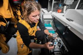
Data was collected over a six-week period in May and June 2021 during The Ocean Race Europe and its prologue. Two teams, Ambersail-2 and AkzoNobel Ocean Racing, carried scientific equipment onboard to capture samples of microplastics as they raced, while a third boat, 11th Hour Racing Team, took measurements of carbon dioxide (CO2), sea temperature, PH levels and salinity, which are key indicators of climate change.
 AkzoNobel Ocean Racing in The Ocean Race Europe | Credit: Sailing Energy/The Ocean Race
The data gathered in the race showed the Baltic Sea to have the highest levels of microplastics in Europe, with 230 particles found per cubic metre, on average double the amount found in the Mediterranean (112 particles per cubic metre) which is considered a hotspot for plastic pollution.
Dr Beck said: “The high abundance of microplastic in the Baltic Sea compared to the Mediterranean Sea is unexpected. Factors such as the time of year that the data is collected can have an impact on the distribution of microplastics. The more data we can gather, from different areas and seasons, the better we can understand the source of the plastics and where they end up.”
The ocean plays a critically important role in climate regulation. It has absorbed over 90% of man-made excess heat since the 1970s and absorbs a quarter of human made carbon CO2, helping to effectively mitigate climate change. However, this absorption causes the ocean to become more acidic, which has an adverse effect on marine life.
Measurements of dissolved CO2 captured during The Ocean Race Europe by 11th Hour Racing Team have been submitted to the Surface Ocean Carbon Dioxide Atlas (SOCAT), which provides data for the Global Carbon Budget, a yearly assessment of CO2 that informs targets and predictions for carbon reduction.
It is vital that scientists understand the levels of CO2 in the ocean to form an accurate budget and keep the world on track to stay within the Paris Agreement goal of limiting global warming to below 1.5 degrees Celsius.
The CO2 data were also analysed by EuroSea, a European Commission-funded programme that improves the ocean observing and forecasting systems. Carbon dioxide levels were found to be highest in the Mediterranean, as a consequence of warm temperatures and very little wind.
 11th Hour Racing Team in The Ocean Race Europe | Credit: Amory Ross/11th Hour Racing/The Ocean Race
Simon Weppe, science lead at The Ocean Race said: “Climate change and plastic pollution have, in mere decades, caused a drastic decline in the health of the ocean. Through The Ocean Race’s unique collaboration between sailors and ocean research organisations, we are helping to grow understanding of these dire issues.
“The more we know of the scale of these problems the better placed we are to take action to combat them; this is crucial, as the state of the seas and the fate of the planet are completely interlinked.
"It's vital that governments act on the scientific evidence to protect and restore our ocean and all that depends on it. The race for the ocean is a race we must win.”
The Ocean Race Europe scientific data collection activity was endorsed by the UN Decade of Ocean Science for Sustainable Development, a global movement to unlock the knowledge needed to reverse the cycle of decline in ocean health and create improved conditions for sustainable development of the ocean.
The Ocean Race’s innovative science programme has been developed in collaboration with 11th Hour Racing, premier partner of The Ocean Race and founding partner of the Racing with Purpose sustainability programme.
Irish Sailor & Artist Joins Women’s Expedition To Research Impact Of Ocean Plastic
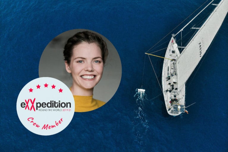
An Irish sailor and visual artist will join next month’s leg of an all-female sailing voyage that’s carrying out important research into the devastating impact of ocean plastic.
Claire McCluskey was a relative novice to sailing when in 2016 she and her partner took part in the Atlantic Rally for Cruisers (ARC), the first of two transatlantic voyages she has under her belt.
Now she’s preparing to set out to sea once again, as she has been chosen from over 10,000 applicants to join the crew of eXXpedition Round The World 2019-2020.
The pioneering all-female sailing voyage and scientific research mission is circumnavigating the globe via four ocean gyres and the Arctic.
And Claire is one of 300 women to join the crew over the voyage’s 30 legs over more than 38,000 nautical miles, studying microplastic and toxins in our oceans.
In February and March, Claire will join Leg 7 of the eXXpedition mission to sail 2,000nm from the Galapagos to Easter Island, gathering samples en route from the South Pacific Gyre — a major plastic accumulation zone.
She will be part of an interdisciplinary team which, in addition to assisting with scientific research at sea, will bring together their unique expertise to think of new ways to tackle the problem of plastic pollution.
As a visual artist, this experience will contribute to Claire’s research into our relationship with the ocean, and will inform a new body of work on her return to Ireland. She will also be writing updates and blog posts for the duration of the four-week voyage.
You can Claire’s participation in the eXXpedition voyage via her GoFundMe fundraiser — for which she is also organising a table quiz next Tuesday 4 February from 7.30pm at Bloody Mary’s on South William St in Dublin — and find out more about the Pacific islands leg HERE.
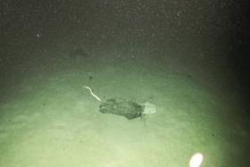
Marine scientists from University College Cork have discovered plastic at the bottom of a deep submarine canyon while investigating cold-water coral habitats.
UCC’s Marine Geology Research Group has been investigating cold-water coral habitats in the Porcupine Bank Canyon, some 320km due west of Dingle, on a research expedition led by UCC’s Dr Aaron Lim on board the Marine Institute’s RV Celtic Explorer.
The team had recovered eight novel monitoring stations, called ‘landers’, worth €450,000 and deployed between 700m and 2500m water depth by the Marine Institute’s Remotely Operated Vehicle (ROV) Holland 1 earlier this summer.
The monitoring stations record the speed, temperatures and direction of the currents around these habitats as well as trapping samples of the food, sediments and microplastic being deposited around the corals, to understand conditions and how the corals are coping with changing oceans.
The researchers found plastic in the bottom of one canyon at 2,125m water depth — as deep as ten Eiffel Towers stacked on top of one another.
The reach of human plastic waste is now confirmed as this deep, even 320km offshore.
“It’s always sad to see plastic rubbish in these otherwise pristine habitats. It’s quite incredible that our plastic waste can get this far out and so deep in the oceans,” said Professor Andy Wheeler of UCC, who has pioneered research on cold-water coral mounds offshore of Ireland over the past 20 years.
“I don’t think people think about this when that dump their rubbish. We’re also trying to see if microplastics are being fed to the corals from above. We’ve just got the samples; let’s hope we're wrong.”
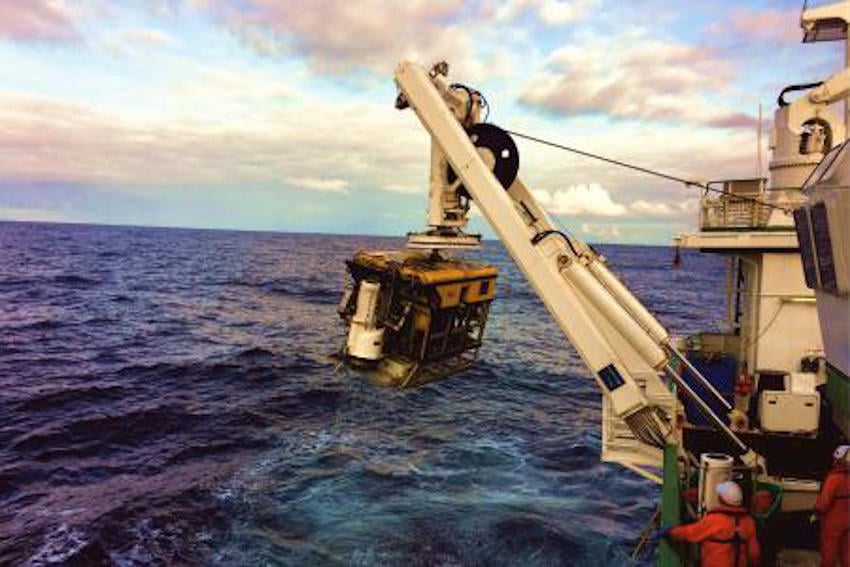 ROV Holland 1 recovering one of the monitoring stations | Photo: UCC
The Porcupine Bank Canyon is teeming with a whole range of cold-water coral habitats, just on Ireland’s doorstep, says Dr Lim.
“The environment is much more dynamic than we thought, with two of the monitoring stations knocked over by the currents; food supply for the coral is variable but the corals are doing okay.
“Some of these habitats have existed for millions of years and have grown so large they resemble hills made of coral, called coral mounds.
“This is the first time eight of these monitoring stations have been deployed and collected using the ROV Holland 1. It will provide scientists with an insight into the processes affecting these cold-water coral habitats, food sources and the impact of microplastics.”
Dr Lim said Ireland’s cold-water coral reefs are found in the cold, dark ocean at water depths of 600m to 1,000m along our continental margin.
“Not only is this expedition vital for understanding these habitats and our impact upon them, it also acts as a baseline to start monitoring how our deep-water habitats here are changing,” he added.
The team has a research agenda which will see them return to the canyon and other habitats alike for a number of years, to monitor the changes in the environment around these habitats. The monitoring stations will be brought back to UCC for detailed analyses.
This research survey is carried out with the support of the Marine Institute, funded under the Marine Research Programme 2014-2020 by the Government to support and promote the Atlantic Ocean Research Alliance, which facilitates common research and knowledge exchange for us to provide healthy, resilient oceans for our future generations.
The survey has also received funding from Science Foundation Ireland, Geological Survey Ireland and UCC.
Irish Teen’s Magnetic Solution To Ocean Microplastic Problem Nets Major Google Science Prize
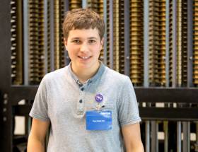
An ingenious technique of using magnetic fluids to filter microplastic from water has netted a West Cork student a major world science award, as The Irish Times reports.
Eighteen-year-old Fionn Ferreira from Ballydehob topped a group of 24 finalists from around the globe to win the 2019 Google Science Fair — an accolade that also comes with a $50,000 educational bursary.
Ferreira, who has just completed his Leaving Cert and was a regular BT Young Scientist entrant at school, experimented with ferrofluid, which adheres to plastic, to see if it would help clear water samples of microplastic.
His findings showed that at least 87% of microplastic could be removed from a given sample — and he is eager to see his research applied in a bigger setting.
The Irish Times has more on the story, and Google has further details on Fionn’s research HERE.
WM Nixon adds: Fionn Ferreira comes from a creative and talented background in Ballydehob – his mother is craft worker Anke Ekhart while his father is the highly-skilled classic boat-builder Rui Ferreira, who has breathed remarkable new life into some old craft, and is noted for building new classics to the highest standards – one of his latest creations is the Dublin Bay Water Wag No 50 Hilda for Martin & Triona Byrne of Dun Laoghaire, which some observers reckon is the best Water Wag ever built in the class’s 132 year history.
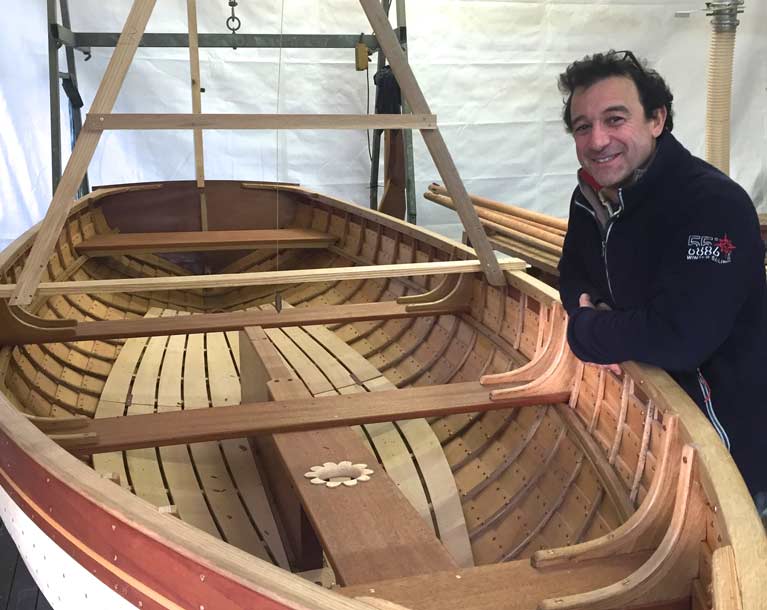 Renowned Ballydehob classic boat-builder Rui Ferreira of Ballydehob – seen here with the Dublin Bay Water Wag Hilda which he completed this year for Martin & Triona Byrne of Dun Laoghaire – is father of award-winning junior scientific inventor Fionn Ferreira. Photo: Ian Malcolm
Microplastic Consumed By Plankton May Interrupt Oceans’ Carbon-Capture Abilities, Says NUI Galway Study
Microplastic ingested by plankton may greatly impair our oceans’ natural carbon-capturing abilities, according to a new study from NUI Galway.
Marine scientists at the university’s Ryan Institute found that microscopic particles of plastic waste in the world’s oceans are interfering with the food chain that cycles CO2 from the surface to the floor, as The Irish Times reports.
The cycle involves the absorption of CO2 from the atmosphere by algae on the ocean surface via photosynthesis. This algae is a food source for zooplankton such as salps, whose faecal matter sinks to the ocean floor.
As much as half of all CO2 produced by humans over the last 200 years has been captured at the bottom of the world’s oceans in this manner, the scientists say.
However, the team have identified that when salps ingest algae along with microplastic particles, their excretions do not sink to the bottom as fast, and may be broken down closer to the surface to release more of their trapped CO2.
“It is very important to point out our study was carried out in a laboratory,” said Dr Tom Doyle of UCC, a partner in the research.
“We now need to go out into the field to further test our hypothesis by quantifying the abundance of microplastics found in salps and their faecal pellets in different areas of our oceans.”
The Irish Times has more on the story HERE.
Try Out Angling At The National Ploughing Championships This Week

#Angling - Novice anglers are invited to try their hand at fishing at the upcoming National Ploughing Championships.
Inland Fisheries Ireland will attend the three days that kick off in Screggan near Tullamore, Co Offaly from tomorrow, Tuesday 18 September, with a fun fishing simulator suitable for all the family.
The simulator will be present at IFI stand within the Department of Communications, Climate Action and the Environment’s tent at the championships.
Fisheries officers will be on hand to answer questions from members of the public around best farming practice on waterways, and how to take up angling as a novice, as well to provide information and guidance around Ireland’s fish species and the aquatic environment.
There will also be aquariums with a range of coarse and game fish species on display.
“The participation of the public in the fisheries resource is vital in ensuring it is protected and enhanced in a sustainable manner for both the recreational and economic benefits it offers to communities nationwide,” says Suzanne Campion, IFI’s head of business development.
“We are looking forward to sharing insights into the fisheries resource, and the indigenous fish species that live within it, with both the general public and the farming community.”
Also exhibiting at the National Ploughing Championships this year are Leave No Trace Ireland and the Marine Institute’s Explorers Education Programme, who aim to highlight the impact of plastics in our oceans at their stand in the the Department of Community and Rural Affairs tent.
“A truckload of plastic waste finds its way into the ocean every minute of every day, and it is estimated that by 2050 there could be more plastic by weight than fish in the ocean unless behaviours change,” explains Maura Lyons, chief executive of Leave No Trace Ireland.
“Although we are all contributing to this worldwide epidemic, recent campaigns such as Say #No to Plastic have generated an amazing amount of supporters at community levels – particularly with children and families wanting to create change.”
With the research being completed in Ireland and around the world, results of plastics making their way into the ocean are showing a significant impact on the marine environment and animals.
Unprecedented levels of microscopic plastic particles were recently detected in an oceanic survey carried out by phytoplankton, biotoxin and oceanographic scientists from the Marine Institute.
From the larger plastics to clothes fibres from our washing machines all making their way into the ocean, visitors to the Leave No Trace/Explorers Education stand will get an opportunity to learn how long it takes for single-use plastic to break down, as well as receiving tips on how to go plastic free.
Those attending will also get to see live native marine species that are typically found in rock pools around the Irish coast including dogfish, plaice and starfish in the Explorers display boat.
“It is great to see an increased interest from children, schools, communities and businesses in Ireland that have already committed to reducing single-use plastics by offering alternatives for customers,” Lyons says. “These small changes can result in big impacts, which will help encourage a change in behaviours.”
West Of Ireland Among Only Three Ocean Sites Free Of Microplastic In Volvo Ocean Race Data
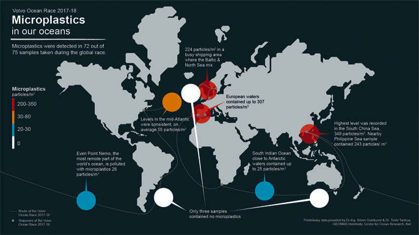
#Microplastic - The West of Ireland is one of only three sites sampled out of 75 during the Volvo Ocean Race with no trace of microplastic particles.
South of Australia and east of Argentina were the other sites found clear of microplastic in findings that give a clear mandate for positive and decisive action from national governments, international organisations, business and individuals to stop plastic polluting our seas.
The most recent data collected, before the race finale in The Hague, by scientific devices on board Team AkzoNobel and Turn the Tide on Plastic found particularly high levels of microplastics — 224 particles per cubic metre — in Skagerrak, a 150-mile strait that runs between Norway, Sweden and Denmark where the outflow from the Baltic Sea meets the Atlantic Ocean.
The highest levels of microplastic — 349 particles per cubic metre — were found in a sample taken in the South China Sea that feeds into the Kuroshio Current and the North Pacific Gyre.
The second highest, at 307 particles per cubic metre, came close from the point where the Mediterranean Sea and Atlantic Ocean meet at the Strait of Gibraltar.
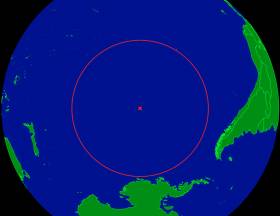
Even close to Point Nemo, the furthest place from land on Earth, where the nearest humans are on the International Space Station, between nine and 26 particles of microplastic per cubic metre were recorded.
The seawater samples were collected during the course of the 45,000-nautical-mile, eight-month race which passed six continents and 12 landmark host cities. The race began in Alicante last October, finishing in The Hague in June.
Anne-Cecile Turner, sustainability programme leader for the Volvo Ocean Race, said: “We have used a sporting event to collect groundbreaking scientific data to provide a global map of microplastics concentrations — even finding them in some of the remotest places on Earth.
“Our ambition is that the data will provide a new benchmark for our understanding of the spread of these ubiquitous particles and offer a template for future scientific methodology.
“With the continuation of the sustainability programme, we will continue our mission to inspire, engage and act as a pioneer, with the aim of restoring ocean health.”
Dr Toste Tanhua of the GEOMAR Institute for Ocean Research Kiel, funded by the Cluster of Excellence Future Ocean, analysed the preliminary microplastics data at their laboratory in Kiel, Germany.
The data has since been uploaded to a National Oceanic and Atmospheric Administration (NOAA) database where scientists are able to access it open source.
Dr Tanhua said the Volvo Ocean Race Science Programme “has contributed enormously to the understanding of microplastic contribution around the world, and has contributed to a global map of CO2 uptake by the oceans. The race has showed that the race yachts and sailors can be excellent science supporters.”
The boats also collect other oceanographic data measurements including temperature, dissolved CO2, salinity and algae content (as chlorophyll a) that gives an indication of levels of ocean health and acidification and supports quantification of the ocean’s uptake of carbon dioxide.
In parallel, 30 scientific drifter buoys deployed during the race are transmitting data that is essential for forecasting of weather and climate changes, in both the short and long term. This is being utilised by the World Meteorological Organisation and UNESCO’s Intergovernmental Oceanographic Commission.
The Volvo Ocean Race Science Programme is funded by Volvo Cars, which is donating €100 from the first 3,000 sales of the new Volvo V90 Cross Country Volvo Ocean Race edition to support the initiative.
Microplastics are often invisible to the naked eye and can take thousands of years to degrade. By collecting information on their levels, the science programme is helping scientists gain insight into the scale of plastic pollution and its impact on marine life.
To build upon the programme’s sustainability achievements, it will be embedded at the heart of the race going forward. And in the run up to the next edition, the programme will continue to organise a range of international Ocean Summits, further expand the education programme and continue to pioneer a scientific programme focussing on ocean plastic.
It will also collaborate with a range of innovative partners, including 11th Hour Racing and UN Environment, to help deliver a lasting legacy and drive real change for a healthy planet.
Since the end of the latest race, the sustainability programme convened a workshop with key global stakeholders from science, academia, the private sector and other institutions, including UN Environment and Mirpuri Foundation, to identify the gaps to fill in order to advance our understanding of these issues and to align our missions.
Fiona Ball, head of responsible business at Sky Ocean Rescue, said: “The data that Turn the Tide on Plastic collected throughout Volvo Ocean Race highlights the critical state of our oceans. By supporting the Turn the Tide on Plastic yacht, Sky Ocean Rescue aims to raise awareness and inspire everyone to make simple, everyday changes to stop our oceans from drowning in plastic. We can all play our part and turn off the plastic tap, now is the time for fundamental change to protect our planet.”
#Microplastic - The Volvo Ocean Race Science Programme has found levels of plastic in areas of the Southern Ocean never before tested.
The groundbreaking data is set to be released today (Friday 18 May) at the Volvo Ocean Race Ocean Summit, which explores the issues and solutions to the plastic crisis, at the race stopover in Newport, Rhode Island.
The findings show that close to Point Nemo, the oceanic pole on inaccessibility, there were between nine and 26 particles of microplastic per cubic metre.
As the boats sailed close to Cape Horn, off the tip of South America, measurements increased to 57 particles per cubic metre.
Levels of 45 particles per cubic metre were recorded 452km from Auckland, New Zealand, where the leg began, and only 12 particles per cubic metre were found 1000 km from the finish in stopover city Itajaí.
The difference in measurements could be explained by ocean currents carrying the microplastics great distances, scientists say.
The highest levels of microplastic found so far — 357 particles per cubic metre — were found in a sample taken in the South China Sea, east of Taiwan, an area that feeds into the Great Pacific Ocean Gyre.
Dr Sören Gutekunst of the GEOMAR Institute for Ocean Research Kiel, funded by the Cluster of Excellence Future Ocean, analysed the preliminary microplastics data at the laboratory in Kiel, Germany.
“This is the first ever data that the scientific community has been able to analyse from a relatively inaccessible part of our blue planet,” Dr Gutekunst said.
“Unfortunately, it shows how far and wide microplastics have penetrated our vast oceans and that they are now present in what, until now, many have considered to be untouched, pristine waters.”
The measurements were collected on the 7,600-nautical-mile leg — the longest in the Volvo Ocean Race, from Auckland to Itajaí — by both Turn the Tide on Plastic and Team AkzoNobel.
The boats also collect other oceanographic data measurements including temperature, CO2, salinity and algae content, which gives an indication of levels of ocean acidification.
"It shows how far and wide microplastics have penetrated our vast oceans"
“Such information is extremely valuable as it helps fill in the large gaps in our understanding of how plastic breaks down over a number of years and is spread to the ends of the earth by ocean currents,” said Anne-Cecile Turner, sustainability programme leader for the Volvo Ocean Race.
“It’s also a stark reminder of the pressing need to tackle this plastic crisis head on and governments, businesses and individuals all have a role to play in addressing the problem.”
Point Nemo is so far from land that the nearest humans are often astronauts on the International Space Station, which orbits the Earth at a maximum of 258 miles (416km). Meanwhile the nearest inhabited landmass to Point Nemo is over 1,670 miles (2,700km) away.
Jeremy Pochman, co-founder and strategic director of Vestas 11th Hour Racing and founding principal partner of the Volvo Ocean Race Sustainability Programme, said: “For so long, we have treated the oceans as an inexhaustible resource.
“The data we find here from onboard the boats show that microplastics are found in the most remote places on Earth, a clear sign that all our oceans are under great pressure.
“This is open-source data, available to the public, and easily used to highlight the dangers of single-use plastic. It is one point of engagement in the conversation about solutions toward a circular economy.”
The information comes from the Volvo Ocean Race Science Programme, which has brought together an elite scientific consortium to capture data that will contribute to a better understanding of the world’s ocean and climate.
Microplastics are often invisible to the naked eye and can take thousands of years to degrade. By collecting information on their levels, the mission is helping scientists gain insight into the scale of plastic pollution and its impact upon marine life.
Highest Microplastic Levels Found In South China Sea
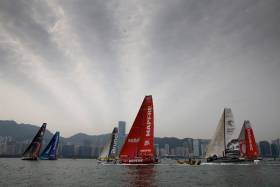
#Microplastic - The Volvo Ocean Race Science Programme has found the highest levels of microplastic in the South China Sea during Leg 6 from Hong Kong to Auckland this past spring.
Preliminary results show a whopping 360 particles of microplastic per cubic metre in the sample from the South China Sea, an area that feeds into the Great Pacific Ocean Gyre.
The Great Pacific Ocean Gyre is one of five major gyres, driven by trade and westerly winds, which collect large concentrations of plastic debris.
In total, this gyre is thought to weigh around seven million tons and is twice the size of Texas.
The previous highest levels of 307 particles per cubic metre were discovered in the area where the Mediterranean Sea and Atlantic Ocean meet.
Sailor Liz Wardley took the samples on Turn the Tide on Plastic as it travelled from Hong Kong east into the north Philippine Sea.
The high readings coincided with the boat entering the Kuroshio current, which feeds the ocean gyre.
Dr Toste Tanhua of the GEOMAR Institute for Ocean Research Kiel, funded by the Cluster of Excellence Future Ocean, analysed the preliminary microplastics data at the laboratory in Kiel, Germany.
“Microplastic particles are mostly coming from land and are passively distributed by currents that can be very local in extent,” Dr Tanhua said. “Since the race yachts are not continuously sampling for microplastic, it can easily be that concentrations are very different for locations close to each other in areas of strong currents.
“The leg 6 data indicate high concentrations of microplastics close to the Asian continent, not unexpected considering the use of single-use plastics in this region.”
The route of Leg 6 partially overlapped the track that the boat sampled during the northbound passage to Hong Kong during Leg 4, providing a second sampling opportunity in some areas.
But there was a notable difference between levels of microplastics recorded during this leg compared to Leg 4 on the approach to Hong Kong from Melbourne.
The latest sample is possibly more representative of actual levels as it was taken closer to land and further northeast than the earlier sample.
Along the route south through the Pacific and crossing the equator, average levels in the areas sampled were around 100 particles per cubic metre. These recorded levels also differed considerably from those recorded during the northbound passage of Leg 4, when just seven particles per cubic metre were measured. Again, prevailing currents in this offshore area will be a major factor affecting microplastic density.
Progressing south towards New Zealand, the concentration increased from 45, 50, 56 to 60 particles per cubic metre in the sample closest to Auckland.
The information comes from the Volvo Ocean Race Science Programme, which has brought together an elite scientific consortium to capture data that will contribute to a better understanding of the world’s ocean and climate.
Microplastics are often invisible to the naked eye and can take thousands of years to degrade. By collecting information on their levels, the mission is helping scientists gain insight into the scale of plastic pollution and its impact upon marine life.
The Volvo Ocean Race Science Programme is funded by Volvo Cars, who are donating €100 from the first 3,000 sales of the new Volvo V90 Cross Country Volvo Ocean Race edition to support the initiative.


, and Dermot O’Kane, Head of Sales, Esri Ireland. Esri Ireland is announcing that its digital mapping system is helping DURL to prevent 13 million litres of polluted wastewater from entering Dublin rivers annually, by locating misconnected household appliances that are expelling polluted water")


 Michael Murphy Schull Harbour Sailing Club (SHSC), Eric Coogan Heineken Ireland, Mark Murphy, Commodore SHSC, Jack Allen SHSC, Carmel O'Regan SHSC, Cornelious Ndlovu, Schull Harbour Hotel Operations Manager and Derval Murphy SHSC")


