Menu

Ireland's sailing, boating & maritime magazine

Inland afloat headers


Displaying items by tag: P&O (Irish Sea)

#FERRY NEWS-P&O Irish Sea's Larne-Troon freight-ferry Norcape (14,087grt) departed the Co. Antrim port last week to be broken-up at ship-breakers in Aliaga, Turkey. She originally served B+I Line as the Tipperary, but her last sailings took place on the North Channel in late November, as the ageing vessel is in her fourth decade of service, writes Jehan Ashmore.

The 125-trailer capacity ro-ro was not replaced on the single-ship operated route which closed for the winter months, though sailings will resume next March by the 92m fast-ferry Express. In the meantime freight traffic will be accommodated on the companies Larne-Cairnryan service.

Yesterday morning Norcape transitted the Strait of Gibraltar having called en-route to Falmouth several days previously. She represented the last vessel to serve in Irish waters with a direct link to B+I Line, the state-owned operator which was sold in 1992 to ICG, parent company of Irish Ferries.

When she arrives in Aliagra, this is where her former P&O fleetmate European Mariner (5,897grt) was scrapped after also serving Larne-Troon sailings until last July. Norcape entered the North Channel route replacing the smaller 53-trailer capacity vessel.

Prior to then Norcape had been in laid-over in Liverpool docks when European Endeavour replaced her in February on the Dublin-Liverpool route. To read more click HERE.

Norcape's return to the Irish Sea service in 2009, reflected her original career for P&O. She was named Puma in 1979 from the Japanese shipyard at the Mitsui Engineering & SB Co Ltd, Tamano, however she was chartered to B+I Line and renamed Tipperary. To read more and to view a deck-drawing profile, click HERE.

Her career started with a new Dublin-Fleetwood route jointly operated with P&O, who contributed with a sister, the Ibex. The P&O brand name Pandoro stood for P and O Ro, their roll-on roll-off freight division. The route's UK port switched to Liverpool in 1988 with Tipperary remaining on the route until sold to North Sea Ferries in 1989 and renamed Norcape.

Before her transfer to the North Sea, Tipperary collided with the 4,674grt bulker Sumburgh Head off the entrance to Dublin Port in 1988. Incidentally the two vessels, under different names and ownership were in Dublin Port in 2010, as previously reported (with photo) click HERE.

Published in Ferry
# CRUISE SHIPS - Dublin Port's 'draft' masterplan which was unveiled to the public today, includes a proposal to develop the first dedicated cruise terminal in the capital port. A site at North Wall Quay Extension has been chosen to handle larger vessels capable of berthing and the location would be closer to the city-centre, writes Jehan Ashmore.
With the increasing demand of the cruiseship sector to Dublin and Irish ports in general, the port recognises the need to further develop future growth prospects and the wider strategic importance to the city. This year the port handled over 85 cruise callers with 130,000 passengers visiting the capital which accrued to €50m to the local economy and €700,000 in direct revenue to the port.

In order to facilitate this growth, the draft proposes switching existing berths used by large cruiseships away from unattractive cargo-docks in Alexandra Basin's West and East and at Ocean Pier. Up to three alternative locations were examined and the port agreed that the option identified in the Dublin City Council's Area Plan of the North Quay Extension is the optimum location.

Before any such development, it would require relocating an existing roll-on roll-off terminal (No.3), which is currently in use by P&O Irish Sea for their Dublin-Liverpool service. The company operate three sailings daily on the central corridor route.

The new facility could accommodate two large cruise ships simultaneously and would be much larger than the 43,524grt The World, the luxury resort vessel operated by Residensea, which docked at the North Wall Extension in 2010 (for report click HERE).

The location is on the doorstep to the East-Link Bridge and the neighbouring O2 Arena and Point Village developed by Harry Crosbie, who called for the relocation of cruise callers to be sited upriver.

According to the draft, the closer proximity to the city-centre would provide a stronger presence and a more accessible link with the city. It would also avoid the unnecessary longer bus transfers between cruise berths and visitor attractions in the city-centre and locations in counties Wicklow and Meath.

Construction of facilities for a cruise terminal would expensive as it will involve new quay walls capable of accepting large cruise vessels but this could only be done after dredging the channel to a depth of 10.5m.

The facilities of the terminal are to incorporate a reception, tourist information and interpretive centre, a dedicated entrance for pedestrians, coaches, vehicles and traffic management measures would be implemented.

In addition the site would also require the expensive exercise in re-locating ESB underwater high-voltage cables. The initial costs suggest to develop new terminal facilities and associated works would be in the region of €30m.

Dublin Port Company, state that due to the relatively low revenues generated by cruise ships, such an investment alone could not be justified, however, they could part-fund the development but additional funding would be required from other sources.

Published in Ferry
As previously reported on Afloat.ie, Celtic Link Ferries look forward to the arrival of a new ro-pax ferry Celtic Horizon (photo), which is currently sailing on the shipping lanes off Algeria, having departed from Palermo, writes Jehan Ashmore.
Celtic Horizon is to be officially launched on the Rosslare-Cherbourg route on 24 October. At 27,552 gross tonnes, she is the largest vessel to operate the French route for CLF with space for 840 passengers, for 200 cars and 120 freight vehicles. Passenger facilities will be boosted with a greater choice of restaurants, bars and a play-zone for kids.

CLF are to charter Celtic Horizon for a five-years and the 25-knot capable vessel will takeover the existing thrice-weekly round trip sailing schedule from ro-pax Norman Voyager. Between 2 January -19 February 2012, CLF will be the only continental ferry operator running services as rivals Irish Ferries will be taking their cruiseferry Oscar Wilde for annual dry-docking. To read more click HERE.

In addition there will be no sailings between Cork-Roscoff, as operators Brittany Ferries last sailing for this year is 29 October, served by 'flagship' Pont-Aven. The 2012 season starts in late March.

Celtic Horizon is the first vessel to be named with a 'Celtic' prefix of part of their ferry operations, since the company brought European Diplomat from former route operators P&O (Irish Sea) in 2005. The freight-ferry renamed Diplomat, served Celtic Link Ferries until 2009. Since then she has been on charter in the Caribbean until this summer when she was sold to the breakers in Alang, India. To read more click HERE.

As for Celtic Horizon, she was built in 2006 and spent her last season this year as Cartour Beta while on charter to C&T's routes between Naples and Sicily, to read more click HERE. The 186m ro-pax is believed to be heading for Gibraltar while en-route to Rosslare.

During her Irish service, she will maintain Italian registry of Bari whereas her predecessor Norman Voyager changes flags from the UK to that of the French tricolour. Both vessels are similar as they share a ro-pax design which has proved popular for Italian shipbuilders Cantieri Navali Visentini.

The 2008 built Norman Voyager of 26,904grt is to revert to LD Lines operation and used on their 'Motorways of the Seas' St. Nazaire-Gijon service, though she was to enter on the Marseilles-Tunis route. Her new role on the Franco-Iberian route sees the replacement of Norman Asturias.

Published in Ferry
With the recent closure of Stena Line fast-ferry services from Dun Laoghaire and Rosslare, this leaves just four such services operating this winter between Ireland and Britain. By November only half of these services will be running on routes out of Dublin and Larne, writes Jehan Ashmore.
Currently three of these four services are employed on North Channel routes. P&O Ferries operate their fast-craft Express (1998/5,902 grt) on the one-hour route to Cairnryan which is also served by conventional ferry sisters that take two-hours. Since March the fast-ferry also joined the freight-ferry on the Troon route for the start of seasonal summer sailings which are to end on 3rd October.

The third service between Belfast-Stranraer is in the hands of rivals Stena Line which maintain the HSS Stena Voyager (1996/19,638 grt) on sailings but only to around mid-November. She will be replaced by conventional sister-ships which will be introduced on the North Channel's newest port when services switch from Stranraer to a new terminal close to Cairnryan.

Finally the fourth fast-ferry is Irish Ferries marketed 'Dublin Swift' service which runs on the Dublin-Holyhead route served by Jonathan Swift (1999/5,989 grt). The craft built by Austal in Fremantle, operates alongside the conventional cruise-ferry Ulysses.

Stena Line's decision to terminate HSS Stena Explorer sailings between Dun Laoghaire-Holyhead this day last week follows fast-ferry Stena Lynx III's end-of-season Rosslare-Fishguard sailings earlier this month.

From next year, Dun Laoghaire-Holyhead sailings are to be seasonal-only and according to Stena Line they hope to resume fast-ferry sailings in April or May though no exact date has been set. Unlike the central corridor route which was entirely dependent on HSS operations, the Rosslare-Fishguard route remains operating year-round with the conventional ferry Stena Europe.

As a result of the discontinued fast-ferries, the HSS Stena Explorer is now spending a lay-up period in the Welsh port for the winter. The smaller Stena Lynx III is also 'wintering' but in on the opposite side of the Irish Sea in Dun Laoghaire, where the vessel has done so in previous years.

The lay-up of both fast-ferries in Dun Laoghaire and Holyhead is ironic considering that neither ports' are connected by the very craft that used to share sailing rosters in recent years. In addition the wintering of these catamaran craft is the first time that this has occurred since the pioneering Stena Sea Lynx fast-ferry launched such sailings in 1993.

This first 'Lynx' provided seasonal sailings on the route with conventional car-ferry Stena Hibernia, the former St. Columba, custom-built in 1977 for Sealink /British Rail. She was given a second name under Stena ownership, the Stena Adventurer and remained on the 57 nautical-mile route until replaced in 1996 by the year-round operated HSS Stena Explorer.

Apart from cross-channel fast-ferry services, the Isle of Man is served by the Isle of Man Steam Packet Co. Ltd's routes linking the islands capital Douglas with Belfast, Dublin, Heysham and Liverpool (Birkenhead) in the winter. These routes include seasonal services which are operated by a combination of conventional tonnage using Ben-My-Chree and fast-ferry Manannan (1998/5,089grt), a former US Navy vessel, to read more click HERE. For sailing schedules, vessel type deployed on route and for fares click HERE.

Published in Ferry
With less than a week in service on the Larne-Troon port route, the ro-ro freight ferry Norcape has replaced the European Mariner which is reportedly sold to Turkish ship-breakers, writes Jehan Ashmore.
The Norcape (1979/14,087grt) entered service on 17 July and she brings an increased freight boost capacity of 125 trailer units compared to European Mariner's (1977/5,897grt) 53 trailer units. She departed Larne for the final time five days earlier, on her delivery voyage to Izmir in the eastern Mediterranean.

Prior to her arrival on the North Channel, Norcape had been laid-up in Liverpool since February 2010 after the former B+I Line vessel (MV Tipperary) was replaced by European Endeavour on the central corridor route to Dublin. As of this week the ro-pax freight vessel which has been running in a freight-only mode will now carry motorists likewise to her route fleetmates Norbank and Norbay.

With the departure of European Mariner from the Irish Sea, she follows a trio of former Stena Line freight-ferry sisters which were made redundant since the closure of the Belfast-Heysham route late last year. It is believed the sisters Stena Seafarer, Stena Leader and Stena Pioneer have been sold to Russian interests to serve in the Black Sea in connection to the 2014 Winter Olympics in Sochi.

The sisters were renamed, Stena Pioneer became Ant 1, Stena Seafarer is the Ant 2 and Stena Leader is the Anna Marine. They departed Belfast Lough in mid-June to Sevastopol in the Ukraine under the Moldovan flag and with a port of registry in Giurgiulesti.

Published in Ferry
Diplomat, the original ferry that started operations for Celtic Link Ferries in 2005 has been sold to Indian ship-breakers after serving a spell on charter in the Caribbean, writes Jehan Ashmore.
Since leaving the Rosslare-Cherbourg port route in late 2009, the Diplomat has run between Santo Domingo (Dominican Republic) and San Juan (Peurto Rico) for Marine Express. For more click HERE. The freight-ferry was built by Hyundai Heavy Industries in Ulsan, South Korea in 1978 and she was the final 'Searunner' class of 11 ordered by the Stena Rederi.

Launched as the Stena Tranporter, the career of the 16,000 tonnes has spanned over three decades in which the 151m vessel changed through several owners and subsequent vessel renamings.

It was when she served under the name Baltic Ferry, that her most notable career took place in 1982 during her wartime deployment as part of the
Falklands Islands Task Force. The 151m vessel was requisitioned by the British Ministry of Defence which saw the ship engaged in military operations when RAF Harrier Jump-Jet aircraft transferred store supplies from the deck of the ship as part of the war-effort in the South Atlantic Ocean.

In 2001 the vessel undertook ferry operations to Ireland as the European Diplomat on the Dublin-Liverpool route for the P&O (Irish Sea) route network. The following year she was transferred on the direct route to France until P&O pulled the plug on the continental service in December 2004, leaving Irish Ferries as the sole operator.

It was not until February 2005 that the route resumed service but this time under new owners Celtic Link Ferries. The O'Flaherty brothers, owners of a large fishing fleet in Kilmore Quay purchased the vessel and renamed her Diplomat. See PHOTO.

For the next four years she built up a steady customer loyalty between freight-hauliers drivers and car-only accompanying passengers who were accommodated in the ship which had a limited passenger certificate for 114 passengers. In addition she had a license to transport livestock.

Currently Celtic Link Ferries operate the ferry Norman Voyager but the 800-passenger / 200-car ro-pax vessel will only remain on the route until an October debut of a larger sistership the Cartour Beta.

The vessel is running this season between Italy and Sicily and with an added deck the 27,552 tonnes vessel has an increased capacity for passengers, cars and enhanced range of facilities. Recently the company had run a competition to name the new vessel which is to begin a five-year charter on the service between Wexford and Normandy.

Published in Ferry

It may just be another cruiseship visiting Dublin Port today, but the gleaming white painted Costa Marina started her career in complete constrast as a grey-hulled containership, writes Jehan Ashmore.

The cruiseship has some unusual hull design features indicating clues to her origins as the containership Axel Johnson (click PHOTO) notably the pronounced chine bow (horizontal-lines) still clearly visible under her name when launched in 1969 at the Oy Wärtsilä shipyard in Turku, Finland.

She was the leadship of five sisters of over 15,000 tonnes ordered by her Swedish owners, Johnson Line. The next sister completed, Annie Johnson was also converted into a cruiseship and she too serves Costa Cruises as their Costa Allegra.

Axel Johnson measured 174m in length and was fitted with two deck-mounted gantry-cranes to handle containers. Her design even catered for passengers but was limited to just four-persons compared to today near 800 passenger capacity and an increase in tonnage to 25,500. To see how she looks now click PHOTO

Her Scandinavian owners sold the vessel in 1986 though it was not until 1988 that the containership came into the ownership of her current owners Costa Cruises who converted the vessel at the Mariotti Shipyard in Genoa. Two years later the ship emerged as the Costa Marina (to see another click HERE).

She has nine decks which feature restaurants, bars, jacuzzis, pools, gym, treatment rooms, sauna, an outdoor jogging track, theatre, casino, disco and a squok club with PlayStation entertainment. Accommodation comprises for 383 cabins including 8 suites with private balcony and a crew close to 400.

Costa Cruises were founded in 1924 but they are a relative newcomer to Dublin. The vessel departs this evening from Ocean Pier bound for the Icelandic capital of Reykjavik. To view the ship's web-cam click HERE (noting to scroll right down the page).

Costa Marina and indeed larger cruiseships may in the future relocate upriver to berths much closer to the city-centre, should proposals by Dublin City Council take pace. In order to boost tourism numbers a dedicated new cruiseship terminal could be built at a site close to the O2 Arena and East-Link bridge.

The site at North Wall Quay Extension is currently in use by ferry operator P&O (Irish Sea) for their ro-ro route to Liverpool. To read more in a report in yesterday's Irish Times click HERE.

Published in Cruise Liners
Stena Line are to introduce two chartered sisterships in the Autumn to coincide with the opening of a £80m ferryport near Cairnryan, which is to replace Stranraer, as the new Scottish port for their route to Belfast, writes Jehan Ashmore.
At 30,285grt the sisterships Superfast VII and Superfast VIII will be the largest ferries to operate on the North Channel routes. The 203m long pair can take 1,200 passengers, around 660 cars or 110 freight vehicles.

Stena will lease the ferries for a three year period from Tallink, the Baltic Sea based shipping group. (Click here for photo of Superfast VIII in ice-flow waters). The charter arrangement includes an option to extend for a further year.

The distance between the new ferry terminal named the 'Loch Ryan Port' at Old House Point (which is just north of Cairnryan) is approx. 8kms apart from Stranraer taking the coastal (A77) road along the Loch that leads onto to Glasgow. At Cairnryan,  rivals P&O (Irish Sea) who along with predecessing operators have run services on the route to Larne for several decades.

With a speed of 27-knots, passage times on the new Stena Belfast-Cairnryan route will take 2 hours 15 minutes, this compares to the existing time of 2 hours 50 minutes from Stranraer by conventional ferry and 2 hours taken by the HSS fast-ferry.

As a consequence of Stena operating from Loch Ryan Port, passage times by the Superfast sisters will be reduced by 35 minutes as the Belfast terminal was also relocated in recent years. Though despite the relocated ferry terminals, the Superfast sisters scheduled 2 hours 15 minutes sailings from the new port will be slightly longer compared to the HSS Stena Voyager's 2 hour sailing time from Stranraer.

Also serving the Belfast Stranraer route are the conventional ferries, Stena Caledonia (formerly Sealink's St. David built at Harland & Wolff) and Stena Navigator, that served SeaFrance on Dover-Calais sailings as SeaFrance Manet. When the Superfast sisters replace the HSS Stena Explorer and the conventional ferries, perhaps there will be a new a role for the two vessels in replacing expensive to run fast-craft operated elsewhere.

In the meantime the Superfast pair will maintain running on Tallink's 26-hour Helsinki-Rostock until mid-August. The 2001 German will then undergo an extensive refit of passenger facilities and a new freight-only deck will be incorporated to cater for haulage operators increasing use of higher vehicles and double-deck freight units.

The 'Superfast' vessel naming theme derives from the original owners, Greek operator Superfast Ferries, which sold their Scandinavian operations to Tallink in 2006.

Published in Ferry
The ro-ro freight-ferry Norcape departed Dublin Port this evening for what is believed to be her last sailing operating under the colours of P&O (Irish Sea) and in which the 1979 built vessel originally served a career with B+I Line as the Tipperary, writes Jehan Ashmore.
Replacing the 14,087gross tonnes vessel is the 22,152grt ro-pax European Endeavour which is expected to enter service next Tuesday. The vessel built in 2000, can take 130 lorries and has a larger passenger capacity for 210 passengers compared to the existing route's 17,464grt ro-pax sisters Norbay and Norbank.

This will enable P&O to offer up to three Ro-Pax style sailings a day on the 7.5 hour route instead of the previous two-plus one ro-ro (freight-only operated) service. The Norcape could take 125 drop trailers but only had 12-passenger cabins (for freight accompanied truck-drivers).

Norcape was only re-introduced onto the Irish Sea last year but made her final departure tonight as the vessel headed into a foggy Dublin Bay.

In 1979 the Japanese built vessel was launched as the Puma for P&O but was chartered to B+I Line and renamed Tipperary. During the 1980's the vessel first operated a then new Dublin-Fleetwood route jointly operated with P&O, alongside Tipperary's Ro-Ro sister, Ibex. The P&O brand name Pandoro cleverly stood for P and O Ro, their roll-on roll-off freight division. 

TIPPERARY

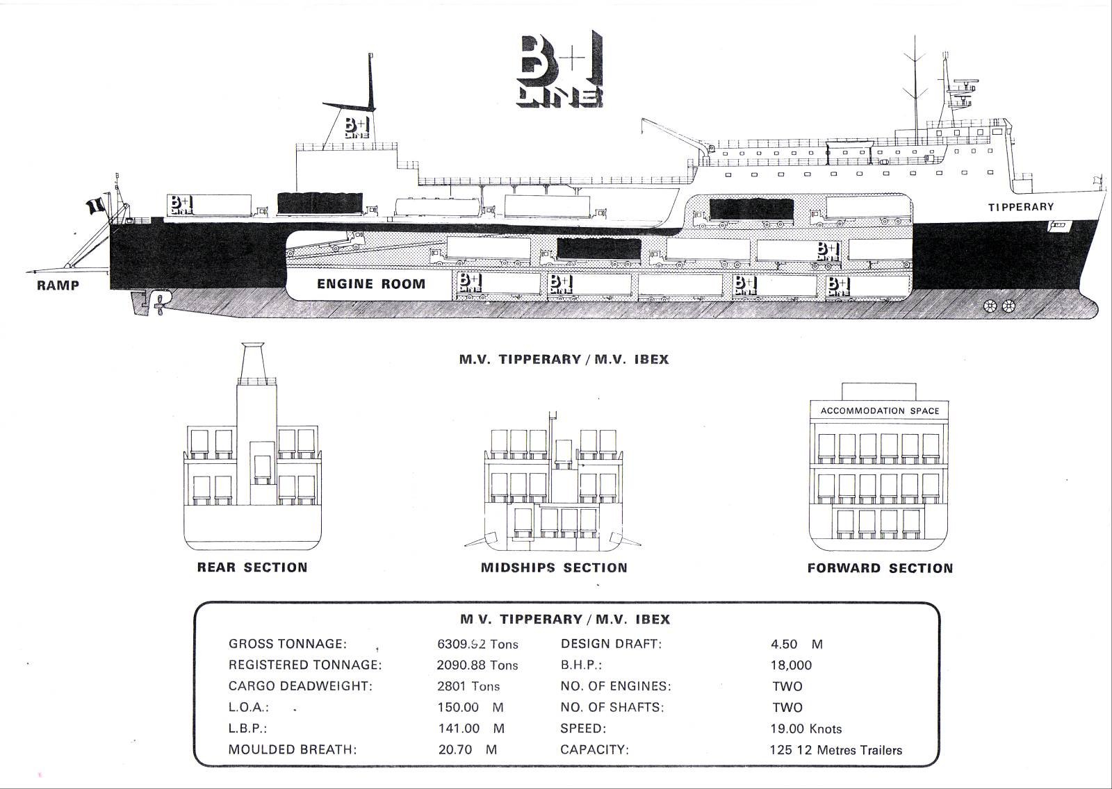
Cut-away deck profile of M.V. Tipperary and sistership of M.V. Ibex

The route's UK port switched to Liverpool in 1988 with Tipperary remaining on the route until sold to North Sea Ferries in 1989 and renamed Norcape. Prior to her transfer to the North Sea, the Tipperary collided with the 4,674grt bulker Sumburgh Head off the entrance to Dublin Port on 18 February 1988. For a report and photo taken of the two vessels which met at the port last year under different names click here.

Like the Tipperary the Sumburgh Head was built in Japan too by Hashihama Zosen KK, Imabari in 1977, yard no. 624. During her Dublin Bay incident, the vessel was owned by Christian Salvesen (Shipping) Ltd based in Edinburgh.

In 1990 she was sold to Barra Head Shipping Ltd and renamed Hood Head under the Irish flag. Three years later sold again to the KG Jebsen group and renamed Husnes.

The Panamanian flagged bulker remained with the Norwegian owner until 2003 when sold to her current owners, Wilson Shipowning AS of Bergen and renamed Wilson Tana, this time under the Maltese flag.

Published in Ferry
17th February 2011

Celtic's French Ferry Figures

Single-route ferry operator, Celtic Link Ferries transported 60,000 passengers, despite last year's challenging economic conditions, writes Jehan Ashmore.
Of that figure, some 48,000 were tourist passengers and the balance of 12,000 accounted for freight accompanied truck-drivers on the Rosslare-Cherbourg route. The thrice weekly service also handled over 50,000 vehicles between tourist and freight lorries.

Operating the route is the 2008 built ro-pax Norman Voyager, at 26,500grt, the vessel has a larger passenger capacity for 800 and additional facilities compared to the previous vessel, Diplomat. In addition the newer Italian built vessel has space for 200 cars and 120 trucks. The ro-pax has a service speed of 22.9 knots is claimed to be the fastest ship serving on the direct routes to France, taking 18-hours.

In 2005 the Wexford based company took over the route from P&O (Irish Sea) and continued to offer what was primarily a freight-only service served by the existing route vessel, the 16,776grt European Diplomat. The vessel was also sold to Celtic Link and renamed Diplomat and could only provide a limited passenger certificate for 74, which was mostly taken up by truck-drivers.

With the introduction in December 2009 of the chartered Norman Voyager from Meridian Marine Management, the Diplomat was laid-up in Waterford (click here). The 1978 built vessel was then chartered by Celtic Link to trade in the Caribbean Sea.

Published in Ferry
Page 1 of 2

General Information on using Waterways Ireland inland navigations

Safety on the Water

All users of the navigations are strongly recommended to make themselves aware of safety on the water for whatever activity they are involved in and to read the advice offered by the various governing bodies and by:

The Dept. of Transport, Ireland: www.gov.ie/transport and The Maritime and Coastguard Agency, UK, The RNLI – Water Safety Ireland for information in terms of drowning prevention and water safety.

Registration of Vessels

All vessels using the Shannon Navigation, which includes the Shannon-Erne Waterways and the Erne System must be registered with Waterways Ireland. Only open undecked boats with an engine of 15 horsepower or less on the Shannon Navigation, and vessels of 10 horsepower or less on the Erne System, are exempt. Registration is free of charge.

Craft registration should be completed online at: https://www.waterwaysireland.org/online-services/craft-registration

Permits for use of the Grand and Royal Canals and the Barrow Navigation

All vessels using the Grand and Royal Canals and the Barrow Navigation must display appropriate valid Permit(s) i.e A Combined Mooring and Passage Permit (€126) and if not intending to move every five days, an Extended Mooring Permit (€152).

Permit applications should be completed online at: https://www.waterwaysireland.org/online-services/canal-permits

Passage on the Royal and Grand Canals – Dublin Area

For boat passage through the locks east of Lock 12 into / out of Dublin on either the Royal or Grand Canals, Masters are requested to contact the Waterways Ireland Eastern Regional Office (M-F 9.30am-4.30pm) on tel: +353(0)1 868 0148 or email [email protected] prior to making passage in order to plan the necessary lock-keeping assistance arrangements.

On the Grand Canal a minimum of two days notice prior to the planned passage should be given, masters should note that with the exception of pre-arranged events, a maximum of 2 boats per day will be taken through the locks, travelling either east or west.

Movements in or out of the city will be organised by prior arrangement to take place as a single movement in one day. Boaters will be facilitated to travel the system if their passage is considered to be safe by Waterways Ireland and they have the valid permit(s) for mooring and passage.

Newcomen Lifting Bridge

On the Royal Canal two weeks’ notice of bridge passage (Newcomen Lifting Bridge) is required for the pre-set lift date, and lock assistance will then also be arranged. A minimum of 2 boats is required for a bridge lift to go ahead.

Waterways Ireland Eastern Regional Office (Tel: +353(0)1 868 0148 or [email protected] ) is the point of contact for the bridge lift.

A maximum number of boats passing will be implemented to keep to the times given above for the planned lifts (16 for the Sat / Sun lifts & 8 for the weekday lifts). Priority will be given on a first come first served basis.

On day of lift, boaters and passengers must follow guidance from Waterways Ireland staff about sequence of passage under bridge & through Lock 1, and must remain within signed and designated areas.

Events Held on the Waterways

All organised events taking place on the waterways must have the prior approval of Waterways Ireland. This is a twelve week process and application forms must be accompanied with the appropriate insurance, signed indemnity and risk assessment. The application should be completed on the Waterways Ireland events page at :

https://www.waterwaysireland.org/online-services/event-approval

Time Limits on Mooring in Public Harbours

On the Shannon Navigation and the Shannon-Erne Waterway craft may berth in public harbours for five consecutive days or a total of seven days in any one month.

On the Erne System, revised Bye Laws state that: No master or owner shall permit a vessel, boat or any floating or sunken object to remain moored at or in the vicinity of any public mooring, including mooring at any other public mooring within 3 kilometres of that location, for more than 3 consecutive days and shall not moor at that same mooring or any other public mooring within 3 kilometres of that location within the following 3 consecutive days without prior permission by an authorised official.

Winter Mooring on the Shannon Navigation and Shannon Erne Waterway

Winter mooring may be availed of by owners during the period 1 Nov to 31 Mar by prior arrangement and payment of a charge of €63.50 per craft. Craft not availing of Winter Mooring must continue to comply with the “5 Day Rule”. Winter Mooring applications should be completed online at : https://www.waterwaysireland.org/online-services/winter-moorings-booking

Owners should be aware that electricity supply and water supply to public moorings is disconnected for the winter months. This is to protect against frost damage, to reduce running costs and to minimise maintenance requirements during the winter months.

Vessel owners are advised that advance purchasing of electricity on the power bollards leading up to the disconnection date should be minimal. Electricity credit existing on the bollards will not be recoverable after the winter decommissioning date. Both services will be reinstated prior to the commencement of the next boating season.

Smart Cards

Waterways Ireland smart cards are used to operate locks on the Shannon Erne Waterway, to access the service blocks, to use the pump-outs along the navigations, to avail of electrical power at Waterways Ireland jetties.

Berthing in Public Harbours

Masters are reminded of the following:

  • Equip their vessel with mooring lines of appropriate length and strength and only secure their craft to mooring bollards and cleats provided for this purpose.
  • Ensure the available berth is suitable to the length of your vessel, do not overhang the mooring especially on finger moorings on floating pontoon moorings.
  • Ensure mooring lines, electric cables and fresh water hoses do not create a trip hazard on public jetties for others users.
  • Carry sufficient fenders to prevent damage to your own vessel, other vessels and WI property.
  • Allow sufficient space between your vessel and the vessel ahead /astern (c.1m) for fire safety purposes and /or to recover somebody from the water.
  • Do not berth more than two vessels side by side and ensure there is safe access/egress at all times between vessels and onto the harbour itself.
  • Do not berth in such a way to prevent use of harbour safety ladders, slipways or pump-outs.
  • Do not allow the bow of your vessel to overhang the walkway of a floating mooring thus creating a hazard for others with an overhanging anchor or bow fendering.
  • Animals are not allowed to be loose or stray at any time.
  • Harbour and jetty infrastructure such as railings, power pedestals, fresh water taps, electric light poles, safety bollards, ladders etc are not designed for the purpose of mooring craft , they will not bear the strain of a vessel and will be damaged.
  • At Carrybridge on the Erne System, Masters of vessels are not permitted to use stern on mooring. Masters of vessels must use the mooring fingers for mooring of vessels and for embarkation / disembarkation from vessels.

Passenger Vessel Berths

Masters of vessels should not berth on passenger vessel berths where it is indicated that an arrival is imminent. Passenger vessels plying the navigations generally only occupy the berths to embark and disembark passengers and rarely remain on the berths for extended periods or overnight.

Lock Lead-in Jetties

Lead-in jetties adjacent to the upstream and downstream gates at lock chambers are solely for the purpose of craft waiting to use the lock and should not be used for long term berthing.

Vessel Wake

Vessel wake, that is, the wave generated by the passage of the boat through the water, can sometimes be large, powerful and destructive depending on the hull shape and engine power of the vessel. This wake can be detrimental to other users of the navigation when it strikes their craft or inundates the shoreline or riverbank. Masters are requested to frequently look behind and check the effect of their wake / wash particularly when passing moored vessels, on entering harbours and approaching jetties and to be aware of people pursuing other activities such as fishing on the riverbank.

Speed Restriction

A vessel or boat shall not be navigated on the Shannon Navigation at a speed in excess of 5 kph when within 200 metres of a bridge, quay, jetty or wharf, when in a harbour or canal or when passing within 100 metres of a moored vessel or boat.

Vessels navigating the Shannon-Erne Waterway should observe the general 5 kph speed limit which applies along the waterway. This is necessary in order to prevent damage to the banks caused by excessive wash from vessels.

Vessels navigating the Erne System should observe the statutory 5kt / 6mph / 10kph speed limit areas.

A craft on the Royal and Grand canals shall not be navigated at a speed in excess of 6km per hour.

A craft on the Barrow Navigation shall not be navigated at a speed in excess of 11km per hour except as necessary for safe navigation in conditions of fast flow.

Bank Erosion

Narrow sections of all the navigations are particularly prone to bank erosion due to the large wash generated by some craft. Masters are requested to be vigilant and to slow down to a speed sufficient to maintain steerage when they observe the wash of their craft inundating the river banks.

Unusual Waterborne Activity

Unusual waterborne vessels may be encountered from time to time, such as, hovercraft or amphibious aircraft / seaplanes. Masters of such craft are reminded to apply the normal “Rule of the Road” when they meet conventional craft on the water and to allow extra room to manoeuvre in the interest of safety.

Sailing Activity

Mariners will encounter large numbers of sailing dinghies from late June to August in the vicinity of Lough Derg, Lough Ree and Lower Lough Erne. Sailing courses are marked by yellow buoys to suit weather conditions on the day. Vessels should proceed at slow speed and with due caution and observe the rules of navigation when passing these fleets, as many of the participants are junior sailors under training.

Rowing

Mariners should expect to meet canoes and vessels under oars on any part of the navigations, but more so in the vicinity of Athlone, Carrick-on-Shannon, Coleraine, Enniskillen and Limerick. Masters are reminded to proceed at slow speed and especially to reduce their wash to a minimum when passing these craft as they can be easily upset and swamped due to their very low freeboard and always be prepared to give way in any given traffic situation.

Canoeing

Canoeing is an adventure sport and participants are strongly recommended to seek the advice of the sport’s governing bodies i.e Canoeing Ireland and the Canoe Association of Northern Ireland, before venturing onto the navigations.

Persons in charge of canoes are reminded of the inherent danger to these craft associated with operating close to weirs, sluice gates, locks and other infrastructure particularly when rivers are in flood and large volumes of water are moving through the navigations due to general flood conditions or very heavy localised precipitation e.g. turbulent and broken water, stopper waves. Shooting weirs is prohibited without prior permission of Waterways Ireland.

Canoeists should check with lockkeepers prior entering a lock to ensure passage is done in a safe manner. Portage is required at all unmanned locks.

Canoe Trail Network – "Blueways"

Masters of powered craft are reminded that a canoe trail network is being developed across all navigations and to expect more organised canoeing along these trails necessitating slow speed and minimum wash when encountering canoeists, rowing boats etc

Rockingham and Drummans Island Canals – Lough Key

It is expected that work on Rockingham and Drummans Island Canals on Lough Key will be completed in 2021. Access to these canals will be for non-powered craft only, eg canoes, kayaks, rowing boats.

Fast Powerboats and Personal Watercraft (Jet Skis)

Masters of Fast Powerboats (speed greater than 17kts) and Personal Watercraft (i.e.Jet Skis) are reminded of the inherent dangers associated with high speed on the water and especially in the confines of small bays and narrow sections of the navigations. Keeping a proper look-out, making early alterations to course and /or reducing speed will avoid conflict with slower vessels using the navigation. Personal Watercraft are not permitted to be used on the canals.

Towing Waterskiers, Wakeboarders, Doughnuts etc

Masters of vessels engaged in any of these activities are reminded of the manoeuvring constraints imposed upon their vessel by the tow and of the added responsibilities that they have to the person(s) being towed. These activities should be conducted in areas which are clear of conflicting traffic. It is highly recommended that a person additional to the master be carried to act as a “look-out” to keep the tow under observation at all times.

Prohibition on Swimming

Swimming in the navigable channel, particularly at bridges, is dangerous and is prohibited due to the risk of being run over by a vessel underway in the navigation.

Age Restrictions on operating of powered craft

In the Republic of Ireland, Statutory Instrument 921 of 2005 provides the legal requirements regarding the minimum age for operating of powered craft. The Statutory Instrument contains the following requirements:

- The master or owner of a personal watercraft or a fast power craft shall take all reasonable steps to ensure that a person who has not attained the age of 16 years does not operate or control the craft

- The master or owner of a pleasure craft powered by an engine with a rating of more than 5 horse power or 3.7 kilowatts shall take all reasonable steps to ensure that a person who has not attained the age of 12 years does not operate or control the craft.

Lifejackets and Personal Flotation Devices (PFDs)

Lifejackets and PFD’s are the single most important items of personal protective equipment to be used on a vessel and should be worn especially when the vessel is being manoeuvred such as entering / departing a lock, anchoring, coming alongside or departing a jetty or quayside.

In the Republic of Ireland, Statutory Instrument 921 of 2005 provides the legal requirements regarding the wearing of Personal Flotation Devices. The Statutory Instrument contains the following requirements:

- The master or owner of a pleasure craft (other than a personal watercraft) shall ensure, that there are, at all times on board the craft, sufficient suitable personal flotation devices for each person on board.

- A person on a pleasure craft (other than a personal watercraft) of less than 7 metres length overall shall wear a suitable personal flotation device while on board an open craft or while on the deck of decked craft, other than when the craft is made fast to the shore or at anchor.

- The master or owner of a pleasure craft (other than a personal watercraft) shall take all reasonable steps to ensure that a person who has not attained the age of 16 years complies with paragraph above.

- The master or owner of a pleasure craft (other than a personal watercraft), shall take all reasonable steps to ensure that a person who has not attained the age of 16 years wears a suitable personal flotation device while on board an open craft or while on the deck of a decked craft other than when it is made fast to the shore or at anchor.

- The master or owner of a pleasure craft (other than a personal watercraft) shall take all reasonable steps to ensure that a person wears a suitable personal flotation device, at all times while – (a) being towed by the craft, (b) on board a vessel or object of any kind which is being towed by the craft.

Further information is available at: http://www.irishstatutebook.ie/eli/2005/si/921/made/en/print

Firing Range Danger Area – Lough Ree

The attention of mariners is drawn to the Irish Defence Forces Firing Range situated in the vicinity of buoys No’s 2 and 3, on Lough Ree on the Shannon Navigation. This range is used regularly for live firing exercises, throughout the year, all boats and vessels should stay clear of the area marked with yellow buoys showing a yellow "X" topmark and displaying the word "Danger".

Shannon Navigation, Portumna Swing Bridge Tolls

No attempt should be made by Masters’ of vessels to pay the bridge toll while making way through the bridge opening. Payment will only be taken by the Collector from Masters when they are secured alongside the jetties north and south of the bridge.

Navigating from Killaloe to Limerick on the Shannon Navigation

The navigation from Killaloe to Limerick involves passage through Ardnacrusha locks, the associated headrace and tailrace and the Abbey River into Limerick City. Careful passage planning is required to undertake this voyage. Considerations include: lock passage at Ardnacrusha, water flow in the navigation, airdraft under bridges on Abbey River in Limerick, state of tide in Limerick

Users are advised to contact the ESB Ardnacrusha hydroelectric power station (00353 (0)87 9970131) 48 hours in advance of commencing their journey to book passage through the locks at Ardnacrusha. It is NOT advised to undertake a voyage if more than one turbine is operating (20MW), due to the increased velocity of flow in the navigation channel, which can be dangerous. To ascertain automatically in real time how many turbines are running, users can phone +353 (0)87 6477229.

For safety reasons the ESB has advised that only powered craft with a capacity in excess of 5 knots are allowed to enter Ardnacrusha Headrace and Tailrace Canals.

Passage through Sarsfield Lock should be booked on +353-87-7972998, on the day prior to travel and it should be noted also that transit is not possible two hours either side of low water.

A Hydrographic survey in 2020 of the navigation channel revealed that the approach from Shannon Bridge to Sarsfield Lock and the Dock area has silted up. Masters of vessels and water users are advised to navigate to the Lock from Shannon bridge on a rising tide one or two hours before High Tide.

Lower Bann Navigation

The attention of all users is drawn to the “Users Code for the Lower Bann”, in particular to that section covering “Flow in the River” outlining the dangers for users both on the banks and in the navigation, associated with high flow rates when the river is in spate. Canoeists should consult and carry a copy of the “Lower Bann Canoe Trail” guide issued by the Canoe Association of Northern Ireland. Users should also contact the DfI Rivers Coleraine, who is responsible for regulating the flow rates on the river, for advisory information on the flow rates to be expected on any given day.

DfI Rivers Coleraine. Tel: 0044 28 7034 2357 Email: [email protected]

Lower Bann Navigation – Newferry – No wake zone

A No Wake Zone exists on the Lower Bann Navigation at Newferry. Masters of vessels are requested to proceed at a slow speed and create no wake while passing the jetties and slipways at Newferry.

Overhead Power Lines (OHPL) and Air draft

All Masters must be aware of the dangers associated with overhead power lines, in particular sailing vessels and workboats with cranes or large air drafts. Voyage planning is a necessity in order to identify the location of overhead lines crossing the navigation.

Overhead power line heights on the River Shannon are maintained at 12.6metres (40 feet) from Normal Summer level for that section of navigation, masters of vessels with a large air draft should proceed with caution and make additional allowances when water levels are high.

If a vessel or its equipment comes into contact with an OHPL the operator should NOT attempt to move the vessel or equipment. The conductor may still be alive or re-energise automatically. Maintain a safe distance and prevent third parties from approaching due to risk of arcing. Contact the emergency services for assistance.

Anglers are also reminded that a minimum ground distance of 30 metres should be maintained from overhead power lines when using a rod and line.

Submarine Cables and Pipes

Masters of vessels are reminded not to anchor their vessels in the vicinity of submarine cables or pipes in case they foul their anchor or damage the cables or pipes. Look to the river banks for signage indicating their presence.

Water Levels - Precautions

Low Water Levels:

When water levels fall below normal summer levels masters should be aware of:

Navigation

To reduce the risk of grounding masters should navigate on or near the centreline of the channel, avoid short cutting in dog-legged channels and navigating too close to navigation markers.

Proceeding at a slow speed will also reduce “squat” effect i.e. where the vessel tends to sit lower in the water as a consequence of higher speed.

Slipways

Reduced slipway length available under the water surface and the possibility of launching trailers dropping off the end of the concrete apron.

More slipway surface susceptible to weed growth requiring care while engaged in launching boats, from slipping and sliding on the slope. Note also that launching vehicles may not be able to get sufficient traction on the slipway once the craft is launched to get up the incline.

Bank Erosion

Very dry riverbanks are more susceptible to erosion from vessel wash.

Lock Share

Maximising on the number of vessels in a lock will ensure that the total volume of water moving downstream is decreased. Lock cycles should be used for vessels travelling each way.

High Water Levels:

When water levels rise above normal summer level masters should be aware of:

Navigation

Navigation marks will have reduced height above the water level or may disappear underwater altogether making the navigable channel difficult to discern.

In narrow sections of the navigations water levels will tend to rise more quickly than in main streams and air draft at bridges will likewise be reduced.

There will also be increased flow rates particularly in the vicinity of navigation infrastructure such as bridges, weirs, locks etc where extra care in manoeuvring vessels will be required.

Harbours and Jetties

Due care is required in harbours and at slipways when levels are at or near the same level as the harbour walkways' as the edge will be difficult to discern especially in reduced light conditions. It is advised that Personal Flotation Devices be worn if tending to craft in a harbour in these conditions.

Slipways

Slipways should only be used for the purpose of launching and recovering of water craft or other objects from the water. Before using a slipway it should be examined to ensure that the surface has sufficient traction/grip for the intended purpose such as launching a craft from a trailer using a vehicle, that there is sufficient depth of water on the slipway to float the craft off the trailer before the concrete apron ends and that the wheels of the trailer do not drop off the edge of the slipway. That life-saving appliances are available in the vicinity, that the vehicle is roadworthy and capable of coping with the weight of the trailer and boat on the incline. It is recommended that slipway operations are conducted by two persons.

Caution to be Used in Reliance upon Aids to Navigation

The aids to navigation depicted on the navigation guides comprise a system of fixed and floating aids to navigation. Prudent mariners will not rely solely on any single aid to navigation, particularly a floating aid to navigation. With respect to buoys, the buoy symbol is used to indicate the approximate position of the buoy body and the ground tackle which secures it to the lake or river bed. The approximate position is used because of the practical limitations in positioning and maintaining buoys in precise geographical locations. These limitations include, but are not limited to, prevailing atmospheric and lake/river conditions, the slope of and the material making up the lake/river bed, the fact that the buoys are moored to varying lengths of chain, and the fact that the buoy body and/or ground tackle positions are not under continuous surveillance. Due to the forces of nature, the position of the buoy body can be expected to shift inside and outside the charted symbol.

Buoys and perches are also moved out of position or pulled over by those mariners who use them to moor up to instead of anchoring. To this end, mariners should always monitor their passage by relating buoy/perch positions with the published navigation guide. Furthermore, a vessel attempting to pass close by always risks collision with a yawing buoy or with the obstruction that the buoy or beacon/perch marks.

Masters of Vessels are requested to use the most up to date Navigation guides when navigating on the Inland Waterways.

Information taken from Special Marine Notice No 1 of 2023