Menu

Ireland's sailing, boating & maritime magazine

Inland afloat headers


Displaying items by tag: Ports & Shipping news

#ShippingReview - Jehan Ashmore reviews the shipping scene from among the following stories over the last fortnight.

The International Maritime Organisation IMO reach agreement to maintain deadline of 2020 for introducing global cap of 0.5% sulphur content in marine fuels.

At the All-Island Civic Dialogue on Brexit, Taoiseach Enda Kenny has forecast “vicious” negotiations over Brexit. The forum follows the issue of Irish ports where the UK proposed to transfer frontline immigration controls to avoid enforcing a ‘hard border’ between the North and the Republic.

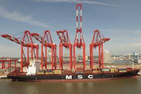
Liverpool2, a £400 million deep-water container port officially opened as an ocean gateway for the UK and connecting services to Ireland. The Port of Liverpool terminal is capable of handling ‘mega’ containerships, and has a catchment of over 35 million people, almost 58% of the UK’s population.

The European Sea Ports Organisation (ESPO) has elected Eamon O’Reilly as Chairman for the next four years. Earlier this year ESPO held their annual conference for the first time in Dublin which was hosted by the port company in which O’Reilly has been serving as Chief Executive since 2010.

Published in Ports & Shipping

#NewEPSOchairman - At the European Sea Ports Organisation (ESPO) General Assembly held in Brussels Eamon O’Reilly was unanimously elected as Chairman following a vote held yesteray. O'Reilly succeeds Santiago Garcia-Mila who chaired the organisation during the last four years.

The General Assembly also elected Annaleena Mäkilä and Bernard Mazuel as Vice-Chairs. Ms Mäkilä, who is currently Executive Director of the Finnish ports Association now starts a second term in that role. Mr Mazuel is Managing Director of the French Ports Association.

Upon his election, Mr O’ Reilly said: “I am very honoured to have been elected as Chairman of ESPO for the next two years. Over these years, ports will be challenged by the implementation of the Port Regulation and other legislative initiatives. There will also be a continuing need for ports to plan and finance major infrastructure investment at the key nodes of Europe’s transport networks. Overarching these challenges, however, is the global problem of climate change and how our industry plays its part in addressing this enormous issue.

“I would like to thank the Members of ESPO for putting their trust in me and I look forward to working with Isabelle and her excellent team as we represent the interests of Europe’s ports in our response to these challenges in the years ahead.”

Mr. O’Reilly has been serving as Chief Executive of the Dublin Port Company since 2010.

Today, ESPO has also published its Annual Report 2015-2016, which outlines the activities of the organisation over the past year. A copy of the report can be found here.

In addition, tonight will see the celebration of the 8th annual ESPO Award on Societal integration. The theme of this year is nature in ports. European Transport Commissioner Violeta Bulc will be announcing the winner at a ceremony taking place at the Palais d’Egmont in Brussels.

Published in Ports & Shipping

#PortSnapshot - Shipping movements in the Port of Cork have included in recent days a diverse range of vessels that are based and have visited the natural harbour, writes Jehan Ashmore.

Outlined below are vessels that Afloat.ie have tracked and their respective business activity.

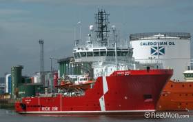
Kinsale GasField Supply Support Ship: Ocean Spey a supply tug support vessel, newly introduced at the Kinsale Energy Ltd facility (formerly Marathon Oil) is currently operating offshore. The 66m vessel is reported to be registered in Ireland and is serving the pair of gas rig platforms located approximately 50kms off the south coast of Cork. Afloat will have more to report on Ocean Spey.

The vessel which also has anchor handling capabilities was built in 2000 and has a 1,864 gross tonnage. Meanwhile the main Kinsale Gasfield standby support ship, Pearl, operated by Cork based Mainport Group, (owners subsidiary Seahorse), is currently at the lay-by berth at Cork Dockyard, Rushbrooke near Cobh.

Brittany Ferries Flagship Service: Pont-Aven, Brittany Ferries flagship of 41,700 gross tonnage made her final Cork-Roscoff end of season sailing on Saturday.

In advance of the season the cruiseferry was fitted with 'scrubbers' to reduce harmful sulphur emissions (the only ferry in Irish waters with this 'green' technology as previously explained here).

The Ireland-France route began in 1978, the same year gas was first produced from the Kinsale Head area in the Celtic Sea. The 2,400 passenger/650 car ferry is to resume service in April, 2017.

Dutch Naval Submarine: A more unusual sight to Cork Harbour has been submarine HNLMS Bruinvis of the Royal Netherlands Navy (NATO member). The non-nuclear powered 68m submarine built during the Cold War is equipped with almost 40 torpedoes missiles.

The crew having paid a visit to Cork City for a long weekend departed yesterday using its diesel electric engines. 
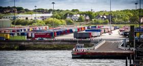
Published in Cork Harbour

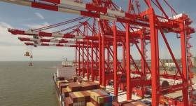
#Liverpool2Opens - Liverpool2, one of the world’s most modern shipping terminals, officially opened last Friday at the Port of Liverpool by the Secretary of State for International Trade, Rt Hon Dr Liam Fox MP.

The £400 million investment by Peel Ports, one of the UK’s biggest port operators, will provide a state-of-the-art ocean gateway for UK importers and exporters with road, rail and canal connections linking directly to the heart of the UK mainland, accessing a catchment of over 35 million people, almost 58% of the UK’s population.

The new deep water facility will complement the existing Royal Seaforth Container Terminal at the existing Port of Liverpool, with each terminal having capacity to handle around 1 million containers per annum. The Port is already the country’s biggest transatlantic port (45% market share) and the only major container port in the north or west of the UK.

Liverpool2, which is one of the UK’s largest private sector infrastructure projects, was developed in response to changing trading patterns and shipping industry trends towards the use of ‘mega’ ocean-going container ships. Liverpool2 will now be able to handle the biggest cargo vessels in the world.

Mark Whitworth, CEO of Peel Ports said: “Today marks the beginning of a new era for the Port of Liverpool. Our investment will help global shippers to transport cargo more efficiently to their end destination with lower costs, congestion and carbon emissions. Liverpool is in the right location, providing state-of-the art facilities and technology, and offers a real competitive advantage with a shorter supply chain and providing an all-water route right to the heart of the UK via the Manchester Ship Canal.

“Liverpool 2 will create a new trading gateway in the UK. We are already exploring and succeeding in creating new opportunities for UK exporters, having recently signed a significant Memorandum of Understanding (MOU) to create a strategic alliance aimed at facilitating international trade and generating new business by promoting trade routes between Liverpool and the west coast of South America via the Panama Canal.”

Secretary of State for International Trade Liam Fox said: “Exporting is vital to the economic health of our nation. This investment at Liverpool2 will boost crucial cargo capacity, create local jobs and is yet another sign that the UK is open for business with the world.

“Liverpool is ideally located to increase our trade with countries west of the UK, including the US, Canada and South America, and this new port opens up even more opportunities with new markets and export destinations for UK businesses.”

Liverpool currently has around 8% of the container market in the UK. This figure would be expected to rise to between 15% and 20%.

Gary Hodgson, Chief Operating Officer of Peel Ports, added: “Being able to compete on the scale offered by Liverpool2 is only one aspect of how we’re transforming the port. Our real driving force is a commitment to customers, whether shipping lines or cargo owners, and helping them to achieve their business vision.

“As well as investing in the infrastructure and technology, we’re providing a more integrated service to our customers, whether that’s at the quayside, through port-centric logistics facilities or our wider network of ports.”

The occasion was marked with a major event for nearly 300 customers and stakeholders, featuring pyrotechnics during the opening ceremony and a performance by Alison Moyet.

The new expanded port facility will create an estimated 5,000 jobs direct and indirect jobs, stimulate further growth in the North-west and help to rebalance the UK economy.

Key facts and figures

The terminal construction has seen a site of around 16 hectares reclaimed from the sea. There is a new 854m quay wall and land created from 5.5 million tonnes of sand and silt dredged from the Mersey. The site is large enough to accommodate the stadiums of all four major Liverpool and Manchester football clubs.

The site currently has five ‘megamax’ ship to shore (STS) transfer cranes and 12 quayside container handling cranes (known as CRMGs). Ultimately there will be another three STS cranes and 10 CRMGs. These alone have cost £100m.

The apex of the STS cranes is 92m – four metres short of the height of Westminster’s Elizabeth Tower (Big Ben clock tower). When the boom is raised, it is more than 130m high.

35 million people in the UK & Ireland live closer to Liverpool than the traditional container ports in the South of England.

58% of the UK’s population is closer to Liverpool than its competitor ports in the south.

112km radius around Liverpool has the largest volume and density of large warehousing of any UK region.

More than 28% of the UK’s large warehousing is located in that area.

The North-west has seen a number of significant investments in supply chain warehousing, including warehouses to serve Waitrose, Aldi, Poundland, B&M, Matalan, Missguided and many others.

Published in Ports & Shipping

#Soft/HardPorts - The Irish Times writes delegates at the All-Island Civic Dialogue on Brexit held in Dublin yesterday, heard that the UK are unaware of the hurt and anger towards it across EU.

Taoiseach Enda Kenny has forecast “vicious” negotiations over Brexit, reflecting a belief in Government circles that the British have underestimated the level of antagonism towards them across the European Union.

Top-level sources in Government believe there is little appreciation on the part of the UK government of the level of hostility they are likely to face once prime minister Theresa May triggers article 50 of the Lisbon Treaty.

New trading arrangements between the UK and the EU will have to be agreed by the remaining 27 member states and there are signs that at least some of those countries are determined to drive a hard bargain.

As previously reported on Afloat.ie, the issue of Irish ports and airports is where the UK proposed to transfer frontline immigration controls in measures to avoid enforcing a ‘hard border’ between the North and the Republic.

Speaking earlier this month, Northern Ireland Secretary, James Brokenshire, said that London and Dublin will work to strengthen Ireland’s external borders to prevent illegal migration to the UK.

The move would come into effect once the UK leaves the European Union.

Published in Ports & Shipping

#PortReOrder – Frank McDonald of the Irish Times writes about plans by Dublin Port to ‘soften the hard edge’ between its Port Centre and the still-developing north Docklands.

Dublin Port, for long a nearly enclosed semi-industrial estate at the eastern end of Docklands, is planning to open up to the city with an imaginative scheme to reorder the entire area around its own headquarters off East Wall Road.

Project manager Jim Kelleher, who was responsible for the outstanding Diving Bell restoration on Sir John Rogerson’s Quay, says the aim is to “soften the hard edge” between Port Centre and the still-developing north Docklands area.

Port Centre, designed by Scott Tallon Walker and completed in 1981, has been marooned behind a stone wall that extends all along the east side of the heavily trafficked East Wall Road, which is extremely hostile to pedestrians.

Standing six storeys high on a podium, the new building replaced the port’s old headquarters at the Ballast Office, on the corner of Aston Quay and Westmoreland Street, which in turn was demolished and replaced by a half-hearted “replica”.

An architectural competition in 2014 led to Darmody Architects winning the commission to create a significant public space around Port Centre, including removal of parts of the unlisted stone boundary wall dating from the 1880s.

Principal architect Tim Darmody says his scheme is “all about port-city integration”, with an impressive set of gates on East Wall Road leading to a plaza in front of the port company’s headquarters and a landscaped “garden” to the south of it.

A new boundary made from pre-rusted Corten steel panels will replace the late 19th-century stone wall at southern end of the two-acre site, with a relocated 10-tonne Stothert & Pitt crane, dating from the 1950s, rearing up above the new wall.

This dramatic installation will be “painted, illuminated, celebrated”, as Jim Kelleher says, as a totem for Dublin Port and its history, clearly visible to motorists driving north across the East Link Bridge towards the Port Tunnel and M50 motorway. To read much more of a separate but port related development proposed by Dublin City Council, click here.

Afloat.ie adds among the reasons for the proposed crane relocation is the Alexandra Basin Redevelopment (ABR) project.

There has been a conservation assessment of such structures within the ABR that includes the site where Dublin Graving Docks Ltd operated until closure earlier this year.

In addition Afloat.ie is to further examine the background of the crane in greater detail as it forms part of the capital's port maritime industrial heritage.


Published in Dublin Port

#PortLinks - Irish Sea and Isle of Man ro-ro operators using Heysham Port, in north-west England, now have a new link road, the Bay Gateway connecting the M6, bypassing congestion in Lancaster, writes Jehan Ashmore.

The Bay Gateway opened on Monday and the new road infrastructure will directly benefit the Lancashire port’s main cross Irish Sea clients, Seatruck Ferries and Stena Line. The Irish Sea's only dedicated unaccompanied freight trailer operator, Seatruck operates to ports in the Irish Republic and Northern Ireland. Stena's freight-only Heysham service concentrates solely to Belfast Port. 

Also to benefit the Isle of Man Steam Packet Company whose main year-round route serves Douglas, where seasonal-routes fast-ferry, Manannan will for a second winter lay-up at the Manx capital until at least the end of this year.

In another development at Heysham (Peel Ports Group) has announced they are to invest in a new £10m link-span bridge and fourth berth. This is to accommodate larger ro-ro vessels.

The funding will also see a new pontoon built to support offshore crew transfer vessels, a new port entrance created and various improvements to the port IT and terminal operating systems. Work on the project to expand capacity begins this month and is scheduled to be completed in October 2017.

Port director, David Huck said: “This is a transformational time for Heysham port. Our major investment to increase capacity and flexibility will further strengthen the port’s role as a logistics hub for the region, particularly for services to Ireland and the Isle of Man. We’ve also built in an element of future-proofing, giving us the ability to accommodate projected volumes for many years to come.”

Heysham Port is also the closest to several major offshore infrastructure projects, the proposed National Grid connection of Moorside nuclear power station in Cumbria and the Dong Energy Walney Extension wind-farm.

Published in Ferry

#Charter - Alpha Marine, formerly Island Shipping, based in Wicklow, has seen the return of one of its wind-farm support vessels following a survey charter in the North Sea, writes Jehan Ashmore.

The water-jet propelled Island Panther had been working in the Waddenzee, an intertidal zone of the Ems Estuary located between The Netherlands and Germany. Along this coast are the Frisian /Wadden Islands, an archipelago that lies off these countries and stretches as far as Denmark.

Island Panther which also is a crew transfer vessel, was deployed from the Dutch port of Ijmuiden to conduct the survey zone. The 17m craft operated in the ultra-shallow waters of the survey site.


Published in Ports

#GlobalSulphur - The International Maritime Organistions IMO’s Marine Environment Protection Committee (MEPC) has reached an agreement on global sulphur cap.

The IMO last week agreed in favour of maintaining the deadline of 2020 for introducing a global cap of 0.5% sulphur content in marine fuels.

Responding to the breakthrough, the European Sea Ports Organisation (ESPO) congratulated the IMO on its decision. By setting 2020 as deadline for this global 0.5% sulphur cap, the IMO timing is being aligned with the EU timing as foreseen in the current Sulphur Directive. This will mean equal rules for EU and its neighbouring countries.

European ports are also convinced of the environmental and public health benefits of this reduction target.

Commenting on th decision, ESPO’s Secretary General Isabelle Ryckbost said “It is clear that limiting the sulphur exhaust emissions can have an enormous impact on the local air quality. This decision thus means a big step forward for the maritime and port industry and the people around the ports. In fact, 90% of European ports are very close to urban areas. Moreover, by maintaining 2020, IMO shows that an ambitious greening agenda is possible at global level. We must hope that IMO will demonstrate the same level of ambition when addressing climate change” 

Published in Ports & Shipping

#ShippingReview - Jehan Ashmore reviews the shipping scene from among the following stories over the last fortnight.

Irish exports to the UK were €9.5bn in the first eight months of 2016, a fall of €300m for same period last year according to the Central Statistics Office (CSO).

Operators of a chemical and products tankers, Ardmore Shipping select the UK P&I Club as its second P&I club.

In the Seanad, Minister for Transport Shane Ross has said the transfer of Dún Laoghaire Harbour Company to the local council is ‘imminent’.

The Irish Maritime Development Office (IMDO) has made two new appointments to the organisations key management team.

Page 4 of 39

General Information on using Waterways Ireland inland navigations

Safety on the Water

All users of the navigations are strongly recommended to make themselves aware of safety on the water for whatever activity they are involved in and to read the advice offered by the various governing bodies and by:

The Dept. of Transport, Ireland: www.gov.ie/transport and The Maritime and Coastguard Agency, UK, The RNLI – Water Safety Ireland for information in terms of drowning prevention and water safety.

Registration of Vessels

All vessels using the Shannon Navigation, which includes the Shannon-Erne Waterways and the Erne System must be registered with Waterways Ireland. Only open undecked boats with an engine of 15 horsepower or less on the Shannon Navigation, and vessels of 10 horsepower or less on the Erne System, are exempt. Registration is free of charge.

Craft registration should be completed online at: https://www.waterwaysireland.org/online-services/craft-registration

Permits for use of the Grand and Royal Canals and the Barrow Navigation

All vessels using the Grand and Royal Canals and the Barrow Navigation must display appropriate valid Permit(s) i.e A Combined Mooring and Passage Permit (€126) and if not intending to move every five days, an Extended Mooring Permit (€152).

Permit applications should be completed online at: https://www.waterwaysireland.org/online-services/canal-permits

Passage on the Royal and Grand Canals – Dublin Area

For boat passage through the locks east of Lock 12 into / out of Dublin on either the Royal or Grand Canals, Masters are requested to contact the Waterways Ireland Eastern Regional Office (M-F 9.30am-4.30pm) on tel: +353(0)1 868 0148 or email [email protected] prior to making passage in order to plan the necessary lock-keeping assistance arrangements.

On the Grand Canal a minimum of two days notice prior to the planned passage should be given, masters should note that with the exception of pre-arranged events, a maximum of 2 boats per day will be taken through the locks, travelling either east or west.

Movements in or out of the city will be organised by prior arrangement to take place as a single movement in one day. Boaters will be facilitated to travel the system if their passage is considered to be safe by Waterways Ireland and they have the valid permit(s) for mooring and passage.

Newcomen Lifting Bridge

On the Royal Canal two weeks’ notice of bridge passage (Newcomen Lifting Bridge) is required for the pre-set lift date, and lock assistance will then also be arranged. A minimum of 2 boats is required for a bridge lift to go ahead.

Waterways Ireland Eastern Regional Office (Tel: +353(0)1 868 0148 or [email protected] ) is the point of contact for the bridge lift.

A maximum number of boats passing will be implemented to keep to the times given above for the planned lifts (16 for the Sat / Sun lifts & 8 for the weekday lifts). Priority will be given on a first come first served basis.

On day of lift, boaters and passengers must follow guidance from Waterways Ireland staff about sequence of passage under bridge & through Lock 1, and must remain within signed and designated areas.

Events Held on the Waterways

All organised events taking place on the waterways must have the prior approval of Waterways Ireland. This is a twelve week process and application forms must be accompanied with the appropriate insurance, signed indemnity and risk assessment. The application should be completed on the Waterways Ireland events page at :

https://www.waterwaysireland.org/online-services/event-approval

Time Limits on Mooring in Public Harbours

On the Shannon Navigation and the Shannon-Erne Waterway craft may berth in public harbours for five consecutive days or a total of seven days in any one month.

On the Erne System, revised Bye Laws state that: No master or owner shall permit a vessel, boat or any floating or sunken object to remain moored at or in the vicinity of any public mooring, including mooring at any other public mooring within 3 kilometres of that location, for more than 3 consecutive days and shall not moor at that same mooring or any other public mooring within 3 kilometres of that location within the following 3 consecutive days without prior permission by an authorised official.

Winter Mooring on the Shannon Navigation and Shannon Erne Waterway

Winter mooring may be availed of by owners during the period 1 Nov to 31 Mar by prior arrangement and payment of a charge of €63.50 per craft. Craft not availing of Winter Mooring must continue to comply with the “5 Day Rule”. Winter Mooring applications should be completed online at : https://www.waterwaysireland.org/online-services/winter-moorings-booking

Owners should be aware that electricity supply and water supply to public moorings is disconnected for the winter months. This is to protect against frost damage, to reduce running costs and to minimise maintenance requirements during the winter months.

Vessel owners are advised that advance purchasing of electricity on the power bollards leading up to the disconnection date should be minimal. Electricity credit existing on the bollards will not be recoverable after the winter decommissioning date. Both services will be reinstated prior to the commencement of the next boating season.

Smart Cards

Waterways Ireland smart cards are used to operate locks on the Shannon Erne Waterway, to access the service blocks, to use the pump-outs along the navigations, to avail of electrical power at Waterways Ireland jetties.

Berthing in Public Harbours

Masters are reminded of the following:

  • Equip their vessel with mooring lines of appropriate length and strength and only secure their craft to mooring bollards and cleats provided for this purpose.
  • Ensure the available berth is suitable to the length of your vessel, do not overhang the mooring especially on finger moorings on floating pontoon moorings.
  • Ensure mooring lines, electric cables and fresh water hoses do not create a trip hazard on public jetties for others users.
  • Carry sufficient fenders to prevent damage to your own vessel, other vessels and WI property.
  • Allow sufficient space between your vessel and the vessel ahead /astern (c.1m) for fire safety purposes and /or to recover somebody from the water.
  • Do not berth more than two vessels side by side and ensure there is safe access/egress at all times between vessels and onto the harbour itself.
  • Do not berth in such a way to prevent use of harbour safety ladders, slipways or pump-outs.
  • Do not allow the bow of your vessel to overhang the walkway of a floating mooring thus creating a hazard for others with an overhanging anchor or bow fendering.
  • Animals are not allowed to be loose or stray at any time.
  • Harbour and jetty infrastructure such as railings, power pedestals, fresh water taps, electric light poles, safety bollards, ladders etc are not designed for the purpose of mooring craft , they will not bear the strain of a vessel and will be damaged.
  • At Carrybridge on the Erne System, Masters of vessels are not permitted to use stern on mooring. Masters of vessels must use the mooring fingers for mooring of vessels and for embarkation / disembarkation from vessels.

Passenger Vessel Berths

Masters of vessels should not berth on passenger vessel berths where it is indicated that an arrival is imminent. Passenger vessels plying the navigations generally only occupy the berths to embark and disembark passengers and rarely remain on the berths for extended periods or overnight.

Lock Lead-in Jetties

Lead-in jetties adjacent to the upstream and downstream gates at lock chambers are solely for the purpose of craft waiting to use the lock and should not be used for long term berthing.

Vessel Wake

Vessel wake, that is, the wave generated by the passage of the boat through the water, can sometimes be large, powerful and destructive depending on the hull shape and engine power of the vessel. This wake can be detrimental to other users of the navigation when it strikes their craft or inundates the shoreline or riverbank. Masters are requested to frequently look behind and check the effect of their wake / wash particularly when passing moored vessels, on entering harbours and approaching jetties and to be aware of people pursuing other activities such as fishing on the riverbank.

Speed Restriction

A vessel or boat shall not be navigated on the Shannon Navigation at a speed in excess of 5 kph when within 200 metres of a bridge, quay, jetty or wharf, when in a harbour or canal or when passing within 100 metres of a moored vessel or boat.

Vessels navigating the Shannon-Erne Waterway should observe the general 5 kph speed limit which applies along the waterway. This is necessary in order to prevent damage to the banks caused by excessive wash from vessels.

Vessels navigating the Erne System should observe the statutory 5kt / 6mph / 10kph speed limit areas.

A craft on the Royal and Grand canals shall not be navigated at a speed in excess of 6km per hour.

A craft on the Barrow Navigation shall not be navigated at a speed in excess of 11km per hour except as necessary for safe navigation in conditions of fast flow.

Bank Erosion

Narrow sections of all the navigations are particularly prone to bank erosion due to the large wash generated by some craft. Masters are requested to be vigilant and to slow down to a speed sufficient to maintain steerage when they observe the wash of their craft inundating the river banks.

Unusual Waterborne Activity

Unusual waterborne vessels may be encountered from time to time, such as, hovercraft or amphibious aircraft / seaplanes. Masters of such craft are reminded to apply the normal “Rule of the Road” when they meet conventional craft on the water and to allow extra room to manoeuvre in the interest of safety.

Sailing Activity

Mariners will encounter large numbers of sailing dinghies from late June to August in the vicinity of Lough Derg, Lough Ree and Lower Lough Erne. Sailing courses are marked by yellow buoys to suit weather conditions on the day. Vessels should proceed at slow speed and with due caution and observe the rules of navigation when passing these fleets, as many of the participants are junior sailors under training.

Rowing

Mariners should expect to meet canoes and vessels under oars on any part of the navigations, but more so in the vicinity of Athlone, Carrick-on-Shannon, Coleraine, Enniskillen and Limerick. Masters are reminded to proceed at slow speed and especially to reduce their wash to a minimum when passing these craft as they can be easily upset and swamped due to their very low freeboard and always be prepared to give way in any given traffic situation.

Canoeing

Canoeing is an adventure sport and participants are strongly recommended to seek the advice of the sport’s governing bodies i.e Canoeing Ireland and the Canoe Association of Northern Ireland, before venturing onto the navigations.

Persons in charge of canoes are reminded of the inherent danger to these craft associated with operating close to weirs, sluice gates, locks and other infrastructure particularly when rivers are in flood and large volumes of water are moving through the navigations due to general flood conditions or very heavy localised precipitation e.g. turbulent and broken water, stopper waves. Shooting weirs is prohibited without prior permission of Waterways Ireland.

Canoeists should check with lockkeepers prior entering a lock to ensure passage is done in a safe manner. Portage is required at all unmanned locks.

Canoe Trail Network – "Blueways"

Masters of powered craft are reminded that a canoe trail network is being developed across all navigations and to expect more organised canoeing along these trails necessitating slow speed and minimum wash when encountering canoeists, rowing boats etc

Rockingham and Drummans Island Canals – Lough Key

It is expected that work on Rockingham and Drummans Island Canals on Lough Key will be completed in 2021. Access to these canals will be for non-powered craft only, eg canoes, kayaks, rowing boats.

Fast Powerboats and Personal Watercraft (Jet Skis)

Masters of Fast Powerboats (speed greater than 17kts) and Personal Watercraft (i.e.Jet Skis) are reminded of the inherent dangers associated with high speed on the water and especially in the confines of small bays and narrow sections of the navigations. Keeping a proper look-out, making early alterations to course and /or reducing speed will avoid conflict with slower vessels using the navigation. Personal Watercraft are not permitted to be used on the canals.

Towing Waterskiers, Wakeboarders, Doughnuts etc

Masters of vessels engaged in any of these activities are reminded of the manoeuvring constraints imposed upon their vessel by the tow and of the added responsibilities that they have to the person(s) being towed. These activities should be conducted in areas which are clear of conflicting traffic. It is highly recommended that a person additional to the master be carried to act as a “look-out” to keep the tow under observation at all times.

Prohibition on Swimming

Swimming in the navigable channel, particularly at bridges, is dangerous and is prohibited due to the risk of being run over by a vessel underway in the navigation.

Age Restrictions on operating of powered craft

In the Republic of Ireland, Statutory Instrument 921 of 2005 provides the legal requirements regarding the minimum age for operating of powered craft. The Statutory Instrument contains the following requirements:

- The master or owner of a personal watercraft or a fast power craft shall take all reasonable steps to ensure that a person who has not attained the age of 16 years does not operate or control the craft

- The master or owner of a pleasure craft powered by an engine with a rating of more than 5 horse power or 3.7 kilowatts shall take all reasonable steps to ensure that a person who has not attained the age of 12 years does not operate or control the craft.

Lifejackets and Personal Flotation Devices (PFDs)

Lifejackets and PFD’s are the single most important items of personal protective equipment to be used on a vessel and should be worn especially when the vessel is being manoeuvred such as entering / departing a lock, anchoring, coming alongside or departing a jetty or quayside.

In the Republic of Ireland, Statutory Instrument 921 of 2005 provides the legal requirements regarding the wearing of Personal Flotation Devices. The Statutory Instrument contains the following requirements:

- The master or owner of a pleasure craft (other than a personal watercraft) shall ensure, that there are, at all times on board the craft, sufficient suitable personal flotation devices for each person on board.

- A person on a pleasure craft (other than a personal watercraft) of less than 7 metres length overall shall wear a suitable personal flotation device while on board an open craft or while on the deck of decked craft, other than when the craft is made fast to the shore or at anchor.

- The master or owner of a pleasure craft (other than a personal watercraft) shall take all reasonable steps to ensure that a person who has not attained the age of 16 years complies with paragraph above.

- The master or owner of a pleasure craft (other than a personal watercraft), shall take all reasonable steps to ensure that a person who has not attained the age of 16 years wears a suitable personal flotation device while on board an open craft or while on the deck of a decked craft other than when it is made fast to the shore or at anchor.

- The master or owner of a pleasure craft (other than a personal watercraft) shall take all reasonable steps to ensure that a person wears a suitable personal flotation device, at all times while – (a) being towed by the craft, (b) on board a vessel or object of any kind which is being towed by the craft.

Further information is available at: http://www.irishstatutebook.ie/eli/2005/si/921/made/en/print

Firing Range Danger Area – Lough Ree

The attention of mariners is drawn to the Irish Defence Forces Firing Range situated in the vicinity of buoys No’s 2 and 3, on Lough Ree on the Shannon Navigation. This range is used regularly for live firing exercises, throughout the year, all boats and vessels should stay clear of the area marked with yellow buoys showing a yellow "X" topmark and displaying the word "Danger".

Shannon Navigation, Portumna Swing Bridge Tolls

No attempt should be made by Masters’ of vessels to pay the bridge toll while making way through the bridge opening. Payment will only be taken by the Collector from Masters when they are secured alongside the jetties north and south of the bridge.

Navigating from Killaloe to Limerick on the Shannon Navigation

The navigation from Killaloe to Limerick involves passage through Ardnacrusha locks, the associated headrace and tailrace and the Abbey River into Limerick City. Careful passage planning is required to undertake this voyage. Considerations include: lock passage at Ardnacrusha, water flow in the navigation, airdraft under bridges on Abbey River in Limerick, state of tide in Limerick

Users are advised to contact the ESB Ardnacrusha hydroelectric power station (00353 (0)87 9970131) 48 hours in advance of commencing their journey to book passage through the locks at Ardnacrusha. It is NOT advised to undertake a voyage if more than one turbine is operating (20MW), due to the increased velocity of flow in the navigation channel, which can be dangerous. To ascertain automatically in real time how many turbines are running, users can phone +353 (0)87 6477229.

For safety reasons the ESB has advised that only powered craft with a capacity in excess of 5 knots are allowed to enter Ardnacrusha Headrace and Tailrace Canals.

Passage through Sarsfield Lock should be booked on +353-87-7972998, on the day prior to travel and it should be noted also that transit is not possible two hours either side of low water.

A Hydrographic survey in 2020 of the navigation channel revealed that the approach from Shannon Bridge to Sarsfield Lock and the Dock area has silted up. Masters of vessels and water users are advised to navigate to the Lock from Shannon bridge on a rising tide one or two hours before High Tide.

Lower Bann Navigation

The attention of all users is drawn to the “Users Code for the Lower Bann”, in particular to that section covering “Flow in the River” outlining the dangers for users both on the banks and in the navigation, associated with high flow rates when the river is in spate. Canoeists should consult and carry a copy of the “Lower Bann Canoe Trail” guide issued by the Canoe Association of Northern Ireland. Users should also contact the DfI Rivers Coleraine, who is responsible for regulating the flow rates on the river, for advisory information on the flow rates to be expected on any given day.

DfI Rivers Coleraine. Tel: 0044 28 7034 2357 Email: [email protected]

Lower Bann Navigation – Newferry – No wake zone

A No Wake Zone exists on the Lower Bann Navigation at Newferry. Masters of vessels are requested to proceed at a slow speed and create no wake while passing the jetties and slipways at Newferry.

Overhead Power Lines (OHPL) and Air draft

All Masters must be aware of the dangers associated with overhead power lines, in particular sailing vessels and workboats with cranes or large air drafts. Voyage planning is a necessity in order to identify the location of overhead lines crossing the navigation.

Overhead power line heights on the River Shannon are maintained at 12.6metres (40 feet) from Normal Summer level for that section of navigation, masters of vessels with a large air draft should proceed with caution and make additional allowances when water levels are high.

If a vessel or its equipment comes into contact with an OHPL the operator should NOT attempt to move the vessel or equipment. The conductor may still be alive or re-energise automatically. Maintain a safe distance and prevent third parties from approaching due to risk of arcing. Contact the emergency services for assistance.

Anglers are also reminded that a minimum ground distance of 30 metres should be maintained from overhead power lines when using a rod and line.

Submarine Cables and Pipes

Masters of vessels are reminded not to anchor their vessels in the vicinity of submarine cables or pipes in case they foul their anchor or damage the cables or pipes. Look to the river banks for signage indicating their presence.

Water Levels - Precautions

Low Water Levels:

When water levels fall below normal summer levels masters should be aware of:

Navigation

To reduce the risk of grounding masters should navigate on or near the centreline of the channel, avoid short cutting in dog-legged channels and navigating too close to navigation markers.

Proceeding at a slow speed will also reduce “squat” effect i.e. where the vessel tends to sit lower in the water as a consequence of higher speed.

Slipways

Reduced slipway length available under the water surface and the possibility of launching trailers dropping off the end of the concrete apron.

More slipway surface susceptible to weed growth requiring care while engaged in launching boats, from slipping and sliding on the slope. Note also that launching vehicles may not be able to get sufficient traction on the slipway once the craft is launched to get up the incline.

Bank Erosion

Very dry riverbanks are more susceptible to erosion from vessel wash.

Lock Share

Maximising on the number of vessels in a lock will ensure that the total volume of water moving downstream is decreased. Lock cycles should be used for vessels travelling each way.

High Water Levels:

When water levels rise above normal summer level masters should be aware of:

Navigation

Navigation marks will have reduced height above the water level or may disappear underwater altogether making the navigable channel difficult to discern.

In narrow sections of the navigations water levels will tend to rise more quickly than in main streams and air draft at bridges will likewise be reduced.

There will also be increased flow rates particularly in the vicinity of navigation infrastructure such as bridges, weirs, locks etc where extra care in manoeuvring vessels will be required.

Harbours and Jetties

Due care is required in harbours and at slipways when levels are at or near the same level as the harbour walkways' as the edge will be difficult to discern especially in reduced light conditions. It is advised that Personal Flotation Devices be worn if tending to craft in a harbour in these conditions.

Slipways

Slipways should only be used for the purpose of launching and recovering of water craft or other objects from the water. Before using a slipway it should be examined to ensure that the surface has sufficient traction/grip for the intended purpose such as launching a craft from a trailer using a vehicle, that there is sufficient depth of water on the slipway to float the craft off the trailer before the concrete apron ends and that the wheels of the trailer do not drop off the edge of the slipway. That life-saving appliances are available in the vicinity, that the vehicle is roadworthy and capable of coping with the weight of the trailer and boat on the incline. It is recommended that slipway operations are conducted by two persons.

Caution to be Used in Reliance upon Aids to Navigation

The aids to navigation depicted on the navigation guides comprise a system of fixed and floating aids to navigation. Prudent mariners will not rely solely on any single aid to navigation, particularly a floating aid to navigation. With respect to buoys, the buoy symbol is used to indicate the approximate position of the buoy body and the ground tackle which secures it to the lake or river bed. The approximate position is used because of the practical limitations in positioning and maintaining buoys in precise geographical locations. These limitations include, but are not limited to, prevailing atmospheric and lake/river conditions, the slope of and the material making up the lake/river bed, the fact that the buoys are moored to varying lengths of chain, and the fact that the buoy body and/or ground tackle positions are not under continuous surveillance. Due to the forces of nature, the position of the buoy body can be expected to shift inside and outside the charted symbol.

Buoys and perches are also moved out of position or pulled over by those mariners who use them to moor up to instead of anchoring. To this end, mariners should always monitor their passage by relating buoy/perch positions with the published navigation guide. Furthermore, a vessel attempting to pass close by always risks collision with a yawing buoy or with the obstruction that the buoy or beacon/perch marks.

Masters of Vessels are requested to use the most up to date Navigation guides when navigating on the Inland Waterways.

Information taken from Special Marine Notice No 1 of 2023