Menu

Ireland's sailing, boating & maritime magazine

Inland afloat headers


Displaying items by tag: Power from the Sea

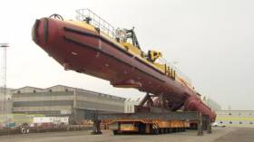
#WorldsLargest - The world's most powerful tidal energy turbine writes the BBC News was assembled at Harland and Wolff shipyard in Belfast.

One of the yard's cranes, Goliath, will lower the 520-tonne structure into Belfast Lough today, Wednesday.

Each of the its twin rotor arms produces 1 megawatt of energy - enough to power thousands of homes when connected to the electricity grid.

After trials in the lough, the turbine will be used off the Orkney Islands.

The 75-metre long structure has taken a year to put together.
It will float on the water with the rotors dropped below the surface.

Published in Belfast Lough

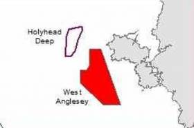
#TidalEnergy - An underwater turbine scheme off Anglesey, north Wales, will help power up to 25,000 homes, reports The Daily Post.

The scheme would create one of the most sought after tidal energy sites in the world, has received a £300,000 boost.

The cash injection is a major step forward in the process to introduce a number of tidal devices, each producing up to 30 megawatts, over a 35 sq km zone, with hopes the first turbines could enter the water in two year’s time.

The Morlais Tidal Energy Demonstration Zone, which has sparked interest from across the globe, was selected for its tidal energy resource and access to infrastructure such as Holyhead Port and potential National Grid connections to accommodate the Wylfa Newydd nuclear plant .

But in order to fund the £30m project EU bids need finalising.

Now the plans have been handed an early boost with a £300,000 donation from Magnox’s Socio-economic scheme, delivered by the Nuclear Decommissioning Authority.

For more on the scheme, click here including separate plans for 'underwater' kites.

Published in Power From the Sea

#PortWaveSub - An agreement between Marine Power Systems (MPS) following testing of key components of a pioneering wave powered renewable energy technology at Pembroke Port has been signed with the facility’s operator, the Port of Milford Haven.

The pump that is central to the concept of a pioneering WaveSub wave energy converter was tested in an onshore tidal lagoon at Pembroke Port. The pump will form part of the quarter size prototype that is now being developed by Swansea-based MPS. The WaveSub project has been part-funded by the European Regional Development Fund through the Welsh Government, with MPS receiving a £2 million grant in October 2015.

In a Memorandum of Understanding between MPS and the Port of Milford Haven, this will see deeper cooperation in WaveSub’s ongoing development. Wave energy is thought to hold great promise for delivering abundant renewable energy from the sea off the coast of Pembrokeshire and globally.

Due to the patent protected innovations of the WaveSub, it can be manufactured at commercial scale from a single facility in Wales and deployed throughout Europe.

Chief Executive of the Port of Milford Haven, Alec Don said, “Supporting companies with skills in the development of technologies and Intellectual Property is central to the Port’s strategy to promote a thriving marine renewable energy industry in the region.

“It’s great news to see Marine Power Systems go ahead with development of the WaveSub. It is just a few short months since Tidal Energy Ltd deployed their DeltaStream device, built here on the dockside, in the waters off the coast. Once again we are firmly committed to providing business support and help in kind and will be introducing MPS to some of the highly skilled companies the local supply chain can undoubtedly provide.”

Dr Gareth Stockman, co-founder and managing director of Marine Power Systems, said, “Marine Power Systems is hugely grateful to the Port of Milford Haven for its support. It has recently helped with the deployment and installation of the pump and it is great to know that they will be able to provide further assistance whilst manufacturing & deploying our ¼ scale prototype.”


Published in Power From the Sea

#PowerFromTheSea - Ireland could be central to the mainstreaming of ocean energy over the next 35 years, according to a new report from the emerging industry.

As The Irish Times reports, the Marine Renewables Industry Association (MRIA) maintains a healthy outlook for the development of wave and tidal energy projects despite revising its predictions for the next decade.

Though "technical challenges" remain in offshore renewables for both wave and wind power generation, Ireland has been marked for "generally strong" policy in the area – and has been encouraged to work with Scotland towards closing the funding gap between research and commercial application.

That view chimes with news from the Maritime Journal, which says Ireland's marine energy market could be worth €15 billion by 2050.

Singled out for its significant contributions in the sector is the SFI Research Centre, Marine Renewable Energy Ireland (MaREI) at University College Cork (UCC), which also houses the Lir National Ocean Test Facility.

That's one of a number of Irish 'innovation hubs' involved in exploring the potential benefits of ocean energy, as previously reported on Afloat.ie – and as discussed at the recent symposium of marine energy leaders in Cork.

Marine Journal has much more on the story HERE.

Published in Power From the Sea

#3DwindMaps -The world’s largest trial of scanning Light Detection and Ranging (LiDAR) technology by Carbon Trust is taking place on Dublin Bay. This is the latest Offshore Wind Accelerator (OWA) project designed to help reduce the cost of energy from offshore wind.

Over the next three months the most comprehensive test of scanning LIDAR technology will take place, where four different scanning LiDAR systems will be put through their paces, alongside three vertical profiling LiDARs for validation purposes. The project is being supported by independent renewable energy company, RES and maritime safety organisation, Commissioners of Irish Lights.

Accurate wind resource measurements are critical to wind farm development because they are used to calculate the potential energy yield from a wind farm, which dictates the terms of the project financing. This can be a significant proportion of the overall project cost, accounting for around 45 percent for an average wind farm.

Scanning LiDAR is not a new technology. Conventionally, it is used by the defence and aerospace industries to monitor for oncoming weather fronts. But it does not have a proven track record in offshore wind.

Normally wind resource is measured using large steel towers called met masts, which require a large capital investment (£10-£12m) incurred at risk before a project gets the go ahead adding significant upfront costs, which could inhibit the exploration of new sites. The OWA project aims to test how accurately scanning LiDAR technology can measure wind resource for potential wind farm sites, which could deliver significant cost savings in the early stages of wind farm development.

The OWA has been working for the past few years to support more cost effective solutions, focusing on the development and commercialisation of a number of floating LiDAR systems, to significantly reduce upfront capital expenditure. Yet measurements taken by both masts and floating LiDAR are limited in that they only provide a measurement of the wind resource at a single point in space. For an offshore wind farm covering an area of up to 200 square kilometres, this can create uncertainty on the wind speed at locations far from the measurement point. This is known as spatial variation, where measurements may not representative of the entire site. This is translated into risk incurring additional financing costs to wind farm development.

Scanning LiDAR technology has the potential to reduce the risk associated with spatial variation. These systems are capable of scanning with a usable range of between 10 to 30 kilometres, to impressive levels of detail, taking over 100 measurements per minute. This allows developers to build a much more detailed picture of a site, not only significantly reducing uncertainty of spatial variation, but also allowing developers to better plan the layouts of the turbines to best exploit the individual wind conditions at the site. Increasing confidence on spatial variation could reduce risk to minimal levels, which can save millions of pounds on a project and reduce the cost of energy from offshore wind.

A difference of only 0.2 mph in wind speed can result in significant variation of yield calculations over the lifetime of a wind farm. It is therefore critical that the industry has confidence in scanning LiDAR devices being sensitive enough to detect such small variations. The OWA trial aims to test the sensitivity of the devices to picking up these variations in wind resource.

Published in Power From the Sea

#WelshPorts – A network of five Associated British Ports (ABP) in South Wales including the Port of Swansea (see report on former ferry operator) had handled more than 12.5 million tonnes of cargo from the region in 2015.

In addition, the port’s launched an array of renewable energy projects and significant new investments.

The 12.5 million tonnes of cargo that passed through the ports included a variety of both traditional and emerging sectors. The import and export of steel remains strong at the ports with Newport holding the title of the UK’s second largest steel handling port.

Sectors that have seen the most growth include the animal feed and fertiliser industry which has seen the ports adapt to accommodate these businesses and support local agriculture. The timber sector also generated noteworthy volumes of cargo.

The Port of Swansea also showcased its versatility and skills with the handling of wind turbine components for the Pen y Cymoedd wind energy project that will continue until spring of this year. On completion, this is due to be the biggest onshore wind farm in Wales and England.

A series of renewable energy projects has seen the ports move towards further energy self-sufficiency. Heavy investment has resulted in several wind and solar projects that collectively generated 7.8 million units of electricity in 2015.

Projects include the 4.5MWp Barry solar array that was commissioned in August 2015 and officially opened by Alun Cairns MP and Jane Hutt AM. The solar project was the result of an investment of over £5 million by ABP.

Further electricity was generated by the 2.3MW wind turbine at the port of Newport, and a series of 250kW rooftop solar projects. The ports are also currently trialling the use of electric vehicles.

These projects serve to reduce the amount of carbon emissions produced by the ports with the energy generated used to power port operations. Any surplus energy is then exported to the national grid.

An additional £4 million was invested in new cargo handling equipment and operational equipment at the ports, including the purchase of a Mobile Harbour Crane and the installation of a new fertiliser bagging line at the Port of Swansea.

This growth has resulted in the permanent workforce at the ports increasing. The operations department has grown by 10% to accommodate customer demand.

As well as welcoming a wide variety of businesses through the lock gates, the ports also serve as a hub for many customers due to their strong network of transport links via road, rail, and sea.

In April 2015 Travis Perkins opened a major distribution centre at ABP Cardiff which represented an investment of £5 million by ABP. This facility resulted in the creation of 100 jobs and is a great example of what ABP’s unique logistical network of ports in South Wales can offer customers.

ABP Director South Wales, Matthew Kennerley, is pleased with the developments across the five ports over the past year.

He said: “Investments throughout 2015 have allowed us to further develop a service tailored to our customer’s needs. The ports continue to be a thriving and unique landscape where businesses can grow and generate strong trade links. We have further investments planned for 2016 that encompass a wide range of port activity.

“The result of ABP’s South Wales operations is an annual contribution of almost £1 billion to the Welsh economy. The vast assortment of businesses that use the ports also means that 15,000 Welsh jobs are supported by them along with an additional 6,000 supported in the rest of the UK.”
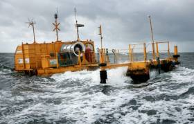
Published in Ports & Shipping

#TurbineToGo - A tidal energy turbine is to be removed from Strangford Lough, Co. Down, reports BBC News.

The SeaGen turbine was lowered into place in 2008 (see report photo) and generates electricity from tidal currents.

Two horizontal axis turbines are anchored to the seabed and are driven by the powerful currents resulting from the tide moving in and out.

Its owners Atlantis Resources (only since July, 2015) said it will be decommissioned later this year.

The company said it had been "an essential research and design platform".

Stephen Ward, the firm's director of power generation, said: "This year, we will embark on the next stage of the R&D (research and development) process and focus on decommissioning the SeaGen device.

"This operation will be the first commercial scale turbine development to be decommissioned and will help us to understand the complete life-cycle of a tidal stream development."

Published in Power From the Sea

#NewOilboat -A new floating production, storage and off-loading (FPSO) vessel, which will produce and store oil coming from Tullow Oil’ s Tweneboa-Enyenra-Ntomme (Ten) offshore oil fields, according to The Irish Times set off for Ghana last weekend.

The massive FPSO (for photo, click link to newspaper) has been under construction in Singapore since October 2013. The boat’s on-schedule departure is an important milestone for the Ten Project which is over 80 per cent complete and on track to start producing oil this July or August.

The FPSO has a nominal production capacity of 80,000 barrels of oil a day and a capacity of 1.7 million barrels. She is 350m long and can accommodate 120 people. The FPSO is expected to arrive in Ghanaian waters in March. She will be stationed above the Ten fields, around 60km from the coast of west Ghana.

Tullow has an interest of just over 47 per cent in the oilfield offshore Ghana.

Published in Power From the Sea

#MarineScience - Apple's latest investment will mean more than a jobs boost as the technology giant has also committed to marine energy prototypes at Galway Bay's 'ocean observatory'.

Yesterday (Wednesday 11 November) Apple announced an expansion of its Cork campus to increase its staff by 1,000 by mid 2017, according to RTÉ News.

But hidden in the headlines was news that the company has signed a memorandum of understanding with the Sustainable Energy Authority of Ireland (SEAI) to assist its grant recipients on marine research and development.

As renewable energy site reNews reports, Apple is providing a total of €1 million – €250,000 a year over four years starting in 2016 – to help ocean energy start-ups put their devices through their paces at the Galway Bay Ocean Energy Test Site.

Apple's vice president of environment, policy and social initiatives Lisa Jackson said the company is "excited by the potential of ocean energy to someday serve as a source of clean power for the data centre we are building in Athenry."

reNEWS has more on the story HERE.

Published in Marine Science

#Windfarm - Scotland is set to host the first floating offshore windfarm in British and Irish waters, as the Guardian reports.

Backed by Norwegian energy giant Statoil, the Hywind Scotland project will comprise five 6MW turbines interconnected by cables and anchored to the seabed, generating energy to power as many as 20,000 homes.

Construction is set to begin off mainland Scotland's easternmost point at Peterhead in the new year, and is expected to see reduced generating costs well below £100MWh.

It's also hoped that the pioneering scheme will lead to the use of more remote and deeper water sites for the windfarms of the future.

The Guardian has more on the story HERE.

Published in Power From the Sea
Page 2 of 6

General Information on using Waterways Ireland inland navigations

Safety on the Water

All users of the navigations are strongly recommended to make themselves aware of safety on the water for whatever activity they are involved in and to read the advice offered by the various governing bodies and by:

The Dept. of Transport, Ireland: www.gov.ie/transport and The Maritime and Coastguard Agency, UK, The RNLI – Water Safety Ireland for information in terms of drowning prevention and water safety.

Registration of Vessels

All vessels using the Shannon Navigation, which includes the Shannon-Erne Waterways and the Erne System must be registered with Waterways Ireland. Only open undecked boats with an engine of 15 horsepower or less on the Shannon Navigation, and vessels of 10 horsepower or less on the Erne System, are exempt. Registration is free of charge.

Craft registration should be completed online at: https://www.waterwaysireland.org/online-services/craft-registration

Permits for use of the Grand and Royal Canals and the Barrow Navigation

All vessels using the Grand and Royal Canals and the Barrow Navigation must display appropriate valid Permit(s) i.e A Combined Mooring and Passage Permit (€126) and if not intending to move every five days, an Extended Mooring Permit (€152).

Permit applications should be completed online at: https://www.waterwaysireland.org/online-services/canal-permits

Passage on the Royal and Grand Canals – Dublin Area

For boat passage through the locks east of Lock 12 into / out of Dublin on either the Royal or Grand Canals, Masters are requested to contact the Waterways Ireland Eastern Regional Office (M-F 9.30am-4.30pm) on tel: +353(0)1 868 0148 or email [email protected] prior to making passage in order to plan the necessary lock-keeping assistance arrangements.

On the Grand Canal a minimum of two days notice prior to the planned passage should be given, masters should note that with the exception of pre-arranged events, a maximum of 2 boats per day will be taken through the locks, travelling either east or west.

Movements in or out of the city will be organised by prior arrangement to take place as a single movement in one day. Boaters will be facilitated to travel the system if their passage is considered to be safe by Waterways Ireland and they have the valid permit(s) for mooring and passage.

Newcomen Lifting Bridge

On the Royal Canal two weeks’ notice of bridge passage (Newcomen Lifting Bridge) is required for the pre-set lift date, and lock assistance will then also be arranged. A minimum of 2 boats is required for a bridge lift to go ahead.

Waterways Ireland Eastern Regional Office (Tel: +353(0)1 868 0148 or [email protected] ) is the point of contact for the bridge lift.

A maximum number of boats passing will be implemented to keep to the times given above for the planned lifts (16 for the Sat / Sun lifts & 8 for the weekday lifts). Priority will be given on a first come first served basis.

On day of lift, boaters and passengers must follow guidance from Waterways Ireland staff about sequence of passage under bridge & through Lock 1, and must remain within signed and designated areas.

Events Held on the Waterways

All organised events taking place on the waterways must have the prior approval of Waterways Ireland. This is a twelve week process and application forms must be accompanied with the appropriate insurance, signed indemnity and risk assessment. The application should be completed on the Waterways Ireland events page at :

https://www.waterwaysireland.org/online-services/event-approval

Time Limits on Mooring in Public Harbours

On the Shannon Navigation and the Shannon-Erne Waterway craft may berth in public harbours for five consecutive days or a total of seven days in any one month.

On the Erne System, revised Bye Laws state that: No master or owner shall permit a vessel, boat or any floating or sunken object to remain moored at or in the vicinity of any public mooring, including mooring at any other public mooring within 3 kilometres of that location, for more than 3 consecutive days and shall not moor at that same mooring or any other public mooring within 3 kilometres of that location within the following 3 consecutive days without prior permission by an authorised official.

Winter Mooring on the Shannon Navigation and Shannon Erne Waterway

Winter mooring may be availed of by owners during the period 1 Nov to 31 Mar by prior arrangement and payment of a charge of €63.50 per craft. Craft not availing of Winter Mooring must continue to comply with the “5 Day Rule”. Winter Mooring applications should be completed online at : https://www.waterwaysireland.org/online-services/winter-moorings-booking

Owners should be aware that electricity supply and water supply to public moorings is disconnected for the winter months. This is to protect against frost damage, to reduce running costs and to minimise maintenance requirements during the winter months.

Vessel owners are advised that advance purchasing of electricity on the power bollards leading up to the disconnection date should be minimal. Electricity credit existing on the bollards will not be recoverable after the winter decommissioning date. Both services will be reinstated prior to the commencement of the next boating season.

Smart Cards

Waterways Ireland smart cards are used to operate locks on the Shannon Erne Waterway, to access the service blocks, to use the pump-outs along the navigations, to avail of electrical power at Waterways Ireland jetties.

Berthing in Public Harbours

Masters are reminded of the following:

  • Equip their vessel with mooring lines of appropriate length and strength and only secure their craft to mooring bollards and cleats provided for this purpose.
  • Ensure the available berth is suitable to the length of your vessel, do not overhang the mooring especially on finger moorings on floating pontoon moorings.
  • Ensure mooring lines, electric cables and fresh water hoses do not create a trip hazard on public jetties for others users.
  • Carry sufficient fenders to prevent damage to your own vessel, other vessels and WI property.
  • Allow sufficient space between your vessel and the vessel ahead /astern (c.1m) for fire safety purposes and /or to recover somebody from the water.
  • Do not berth more than two vessels side by side and ensure there is safe access/egress at all times between vessels and onto the harbour itself.
  • Do not berth in such a way to prevent use of harbour safety ladders, slipways or pump-outs.
  • Do not allow the bow of your vessel to overhang the walkway of a floating mooring thus creating a hazard for others with an overhanging anchor or bow fendering.
  • Animals are not allowed to be loose or stray at any time.
  • Harbour and jetty infrastructure such as railings, power pedestals, fresh water taps, electric light poles, safety bollards, ladders etc are not designed for the purpose of mooring craft , they will not bear the strain of a vessel and will be damaged.
  • At Carrybridge on the Erne System, Masters of vessels are not permitted to use stern on mooring. Masters of vessels must use the mooring fingers for mooring of vessels and for embarkation / disembarkation from vessels.

Passenger Vessel Berths

Masters of vessels should not berth on passenger vessel berths where it is indicated that an arrival is imminent. Passenger vessels plying the navigations generally only occupy the berths to embark and disembark passengers and rarely remain on the berths for extended periods or overnight.

Lock Lead-in Jetties

Lead-in jetties adjacent to the upstream and downstream gates at lock chambers are solely for the purpose of craft waiting to use the lock and should not be used for long term berthing.

Vessel Wake

Vessel wake, that is, the wave generated by the passage of the boat through the water, can sometimes be large, powerful and destructive depending on the hull shape and engine power of the vessel. This wake can be detrimental to other users of the navigation when it strikes their craft or inundates the shoreline or riverbank. Masters are requested to frequently look behind and check the effect of their wake / wash particularly when passing moored vessels, on entering harbours and approaching jetties and to be aware of people pursuing other activities such as fishing on the riverbank.

Speed Restriction

A vessel or boat shall not be navigated on the Shannon Navigation at a speed in excess of 5 kph when within 200 metres of a bridge, quay, jetty or wharf, when in a harbour or canal or when passing within 100 metres of a moored vessel or boat.

Vessels navigating the Shannon-Erne Waterway should observe the general 5 kph speed limit which applies along the waterway. This is necessary in order to prevent damage to the banks caused by excessive wash from vessels.

Vessels navigating the Erne System should observe the statutory 5kt / 6mph / 10kph speed limit areas.

A craft on the Royal and Grand canals shall not be navigated at a speed in excess of 6km per hour.

A craft on the Barrow Navigation shall not be navigated at a speed in excess of 11km per hour except as necessary for safe navigation in conditions of fast flow.

Bank Erosion

Narrow sections of all the navigations are particularly prone to bank erosion due to the large wash generated by some craft. Masters are requested to be vigilant and to slow down to a speed sufficient to maintain steerage when they observe the wash of their craft inundating the river banks.

Unusual Waterborne Activity

Unusual waterborne vessels may be encountered from time to time, such as, hovercraft or amphibious aircraft / seaplanes. Masters of such craft are reminded to apply the normal “Rule of the Road” when they meet conventional craft on the water and to allow extra room to manoeuvre in the interest of safety.

Sailing Activity

Mariners will encounter large numbers of sailing dinghies from late June to August in the vicinity of Lough Derg, Lough Ree and Lower Lough Erne. Sailing courses are marked by yellow buoys to suit weather conditions on the day. Vessels should proceed at slow speed and with due caution and observe the rules of navigation when passing these fleets, as many of the participants are junior sailors under training.

Rowing

Mariners should expect to meet canoes and vessels under oars on any part of the navigations, but more so in the vicinity of Athlone, Carrick-on-Shannon, Coleraine, Enniskillen and Limerick. Masters are reminded to proceed at slow speed and especially to reduce their wash to a minimum when passing these craft as they can be easily upset and swamped due to their very low freeboard and always be prepared to give way in any given traffic situation.

Canoeing

Canoeing is an adventure sport and participants are strongly recommended to seek the advice of the sport’s governing bodies i.e Canoeing Ireland and the Canoe Association of Northern Ireland, before venturing onto the navigations.

Persons in charge of canoes are reminded of the inherent danger to these craft associated with operating close to weirs, sluice gates, locks and other infrastructure particularly when rivers are in flood and large volumes of water are moving through the navigations due to general flood conditions or very heavy localised precipitation e.g. turbulent and broken water, stopper waves. Shooting weirs is prohibited without prior permission of Waterways Ireland.

Canoeists should check with lockkeepers prior entering a lock to ensure passage is done in a safe manner. Portage is required at all unmanned locks.

Canoe Trail Network – "Blueways"

Masters of powered craft are reminded that a canoe trail network is being developed across all navigations and to expect more organised canoeing along these trails necessitating slow speed and minimum wash when encountering canoeists, rowing boats etc

Rockingham and Drummans Island Canals – Lough Key

It is expected that work on Rockingham and Drummans Island Canals on Lough Key will be completed in 2021. Access to these canals will be for non-powered craft only, eg canoes, kayaks, rowing boats.

Fast Powerboats and Personal Watercraft (Jet Skis)

Masters of Fast Powerboats (speed greater than 17kts) and Personal Watercraft (i.e.Jet Skis) are reminded of the inherent dangers associated with high speed on the water and especially in the confines of small bays and narrow sections of the navigations. Keeping a proper look-out, making early alterations to course and /or reducing speed will avoid conflict with slower vessels using the navigation. Personal Watercraft are not permitted to be used on the canals.

Towing Waterskiers, Wakeboarders, Doughnuts etc

Masters of vessels engaged in any of these activities are reminded of the manoeuvring constraints imposed upon their vessel by the tow and of the added responsibilities that they have to the person(s) being towed. These activities should be conducted in areas which are clear of conflicting traffic. It is highly recommended that a person additional to the master be carried to act as a “look-out” to keep the tow under observation at all times.

Prohibition on Swimming

Swimming in the navigable channel, particularly at bridges, is dangerous and is prohibited due to the risk of being run over by a vessel underway in the navigation.

Age Restrictions on operating of powered craft

In the Republic of Ireland, Statutory Instrument 921 of 2005 provides the legal requirements regarding the minimum age for operating of powered craft. The Statutory Instrument contains the following requirements:

- The master or owner of a personal watercraft or a fast power craft shall take all reasonable steps to ensure that a person who has not attained the age of 16 years does not operate or control the craft

- The master or owner of a pleasure craft powered by an engine with a rating of more than 5 horse power or 3.7 kilowatts shall take all reasonable steps to ensure that a person who has not attained the age of 12 years does not operate or control the craft.

Lifejackets and Personal Flotation Devices (PFDs)

Lifejackets and PFD’s are the single most important items of personal protective equipment to be used on a vessel and should be worn especially when the vessel is being manoeuvred such as entering / departing a lock, anchoring, coming alongside or departing a jetty or quayside.

In the Republic of Ireland, Statutory Instrument 921 of 2005 provides the legal requirements regarding the wearing of Personal Flotation Devices. The Statutory Instrument contains the following requirements:

- The master or owner of a pleasure craft (other than a personal watercraft) shall ensure, that there are, at all times on board the craft, sufficient suitable personal flotation devices for each person on board.

- A person on a pleasure craft (other than a personal watercraft) of less than 7 metres length overall shall wear a suitable personal flotation device while on board an open craft or while on the deck of decked craft, other than when the craft is made fast to the shore or at anchor.

- The master or owner of a pleasure craft (other than a personal watercraft) shall take all reasonable steps to ensure that a person who has not attained the age of 16 years complies with paragraph above.

- The master or owner of a pleasure craft (other than a personal watercraft), shall take all reasonable steps to ensure that a person who has not attained the age of 16 years wears a suitable personal flotation device while on board an open craft or while on the deck of a decked craft other than when it is made fast to the shore or at anchor.

- The master or owner of a pleasure craft (other than a personal watercraft) shall take all reasonable steps to ensure that a person wears a suitable personal flotation device, at all times while – (a) being towed by the craft, (b) on board a vessel or object of any kind which is being towed by the craft.

Further information is available at: http://www.irishstatutebook.ie/eli/2005/si/921/made/en/print

Firing Range Danger Area – Lough Ree

The attention of mariners is drawn to the Irish Defence Forces Firing Range situated in the vicinity of buoys No’s 2 and 3, on Lough Ree on the Shannon Navigation. This range is used regularly for live firing exercises, throughout the year, all boats and vessels should stay clear of the area marked with yellow buoys showing a yellow "X" topmark and displaying the word "Danger".

Shannon Navigation, Portumna Swing Bridge Tolls

No attempt should be made by Masters’ of vessels to pay the bridge toll while making way through the bridge opening. Payment will only be taken by the Collector from Masters when they are secured alongside the jetties north and south of the bridge.

Navigating from Killaloe to Limerick on the Shannon Navigation

The navigation from Killaloe to Limerick involves passage through Ardnacrusha locks, the associated headrace and tailrace and the Abbey River into Limerick City. Careful passage planning is required to undertake this voyage. Considerations include: lock passage at Ardnacrusha, water flow in the navigation, airdraft under bridges on Abbey River in Limerick, state of tide in Limerick

Users are advised to contact the ESB Ardnacrusha hydroelectric power station (00353 (0)87 9970131) 48 hours in advance of commencing their journey to book passage through the locks at Ardnacrusha. It is NOT advised to undertake a voyage if more than one turbine is operating (20MW), due to the increased velocity of flow in the navigation channel, which can be dangerous. To ascertain automatically in real time how many turbines are running, users can phone +353 (0)87 6477229.

For safety reasons the ESB has advised that only powered craft with a capacity in excess of 5 knots are allowed to enter Ardnacrusha Headrace and Tailrace Canals.

Passage through Sarsfield Lock should be booked on +353-87-7972998, on the day prior to travel and it should be noted also that transit is not possible two hours either side of low water.

A Hydrographic survey in 2020 of the navigation channel revealed that the approach from Shannon Bridge to Sarsfield Lock and the Dock area has silted up. Masters of vessels and water users are advised to navigate to the Lock from Shannon bridge on a rising tide one or two hours before High Tide.

Lower Bann Navigation

The attention of all users is drawn to the “Users Code for the Lower Bann”, in particular to that section covering “Flow in the River” outlining the dangers for users both on the banks and in the navigation, associated with high flow rates when the river is in spate. Canoeists should consult and carry a copy of the “Lower Bann Canoe Trail” guide issued by the Canoe Association of Northern Ireland. Users should also contact the DfI Rivers Coleraine, who is responsible for regulating the flow rates on the river, for advisory information on the flow rates to be expected on any given day.

DfI Rivers Coleraine. Tel: 0044 28 7034 2357 Email: [email protected]

Lower Bann Navigation – Newferry – No wake zone

A No Wake Zone exists on the Lower Bann Navigation at Newferry. Masters of vessels are requested to proceed at a slow speed and create no wake while passing the jetties and slipways at Newferry.

Overhead Power Lines (OHPL) and Air draft

All Masters must be aware of the dangers associated with overhead power lines, in particular sailing vessels and workboats with cranes or large air drafts. Voyage planning is a necessity in order to identify the location of overhead lines crossing the navigation.

Overhead power line heights on the River Shannon are maintained at 12.6metres (40 feet) from Normal Summer level for that section of navigation, masters of vessels with a large air draft should proceed with caution and make additional allowances when water levels are high.

If a vessel or its equipment comes into contact with an OHPL the operator should NOT attempt to move the vessel or equipment. The conductor may still be alive or re-energise automatically. Maintain a safe distance and prevent third parties from approaching due to risk of arcing. Contact the emergency services for assistance.

Anglers are also reminded that a minimum ground distance of 30 metres should be maintained from overhead power lines when using a rod and line.

Submarine Cables and Pipes

Masters of vessels are reminded not to anchor their vessels in the vicinity of submarine cables or pipes in case they foul their anchor or damage the cables or pipes. Look to the river banks for signage indicating their presence.

Water Levels - Precautions

Low Water Levels:

When water levels fall below normal summer levels masters should be aware of:

Navigation

To reduce the risk of grounding masters should navigate on or near the centreline of the channel, avoid short cutting in dog-legged channels and navigating too close to navigation markers.

Proceeding at a slow speed will also reduce “squat” effect i.e. where the vessel tends to sit lower in the water as a consequence of higher speed.

Slipways

Reduced slipway length available under the water surface and the possibility of launching trailers dropping off the end of the concrete apron.

More slipway surface susceptible to weed growth requiring care while engaged in launching boats, from slipping and sliding on the slope. Note also that launching vehicles may not be able to get sufficient traction on the slipway once the craft is launched to get up the incline.

Bank Erosion

Very dry riverbanks are more susceptible to erosion from vessel wash.

Lock Share

Maximising on the number of vessels in a lock will ensure that the total volume of water moving downstream is decreased. Lock cycles should be used for vessels travelling each way.

High Water Levels:

When water levels rise above normal summer level masters should be aware of:

Navigation

Navigation marks will have reduced height above the water level or may disappear underwater altogether making the navigable channel difficult to discern.

In narrow sections of the navigations water levels will tend to rise more quickly than in main streams and air draft at bridges will likewise be reduced.

There will also be increased flow rates particularly in the vicinity of navigation infrastructure such as bridges, weirs, locks etc where extra care in manoeuvring vessels will be required.

Harbours and Jetties

Due care is required in harbours and at slipways when levels are at or near the same level as the harbour walkways' as the edge will be difficult to discern especially in reduced light conditions. It is advised that Personal Flotation Devices be worn if tending to craft in a harbour in these conditions.

Slipways

Slipways should only be used for the purpose of launching and recovering of water craft or other objects from the water. Before using a slipway it should be examined to ensure that the surface has sufficient traction/grip for the intended purpose such as launching a craft from a trailer using a vehicle, that there is sufficient depth of water on the slipway to float the craft off the trailer before the concrete apron ends and that the wheels of the trailer do not drop off the edge of the slipway. That life-saving appliances are available in the vicinity, that the vehicle is roadworthy and capable of coping with the weight of the trailer and boat on the incline. It is recommended that slipway operations are conducted by two persons.

Caution to be Used in Reliance upon Aids to Navigation

The aids to navigation depicted on the navigation guides comprise a system of fixed and floating aids to navigation. Prudent mariners will not rely solely on any single aid to navigation, particularly a floating aid to navigation. With respect to buoys, the buoy symbol is used to indicate the approximate position of the buoy body and the ground tackle which secures it to the lake or river bed. The approximate position is used because of the practical limitations in positioning and maintaining buoys in precise geographical locations. These limitations include, but are not limited to, prevailing atmospheric and lake/river conditions, the slope of and the material making up the lake/river bed, the fact that the buoys are moored to varying lengths of chain, and the fact that the buoy body and/or ground tackle positions are not under continuous surveillance. Due to the forces of nature, the position of the buoy body can be expected to shift inside and outside the charted symbol.

Buoys and perches are also moved out of position or pulled over by those mariners who use them to moor up to instead of anchoring. To this end, mariners should always monitor their passage by relating buoy/perch positions with the published navigation guide. Furthermore, a vessel attempting to pass close by always risks collision with a yawing buoy or with the obstruction that the buoy or beacon/perch marks.

Masters of Vessels are requested to use the most up to date Navigation guides when navigating on the Inland Waterways.

Information taken from Special Marine Notice No 1 of 2023