Menu

Ireland's sailing, boating & maritime magazine

Inland afloat headers


Displaying items by tag: RV Celtic Voyager

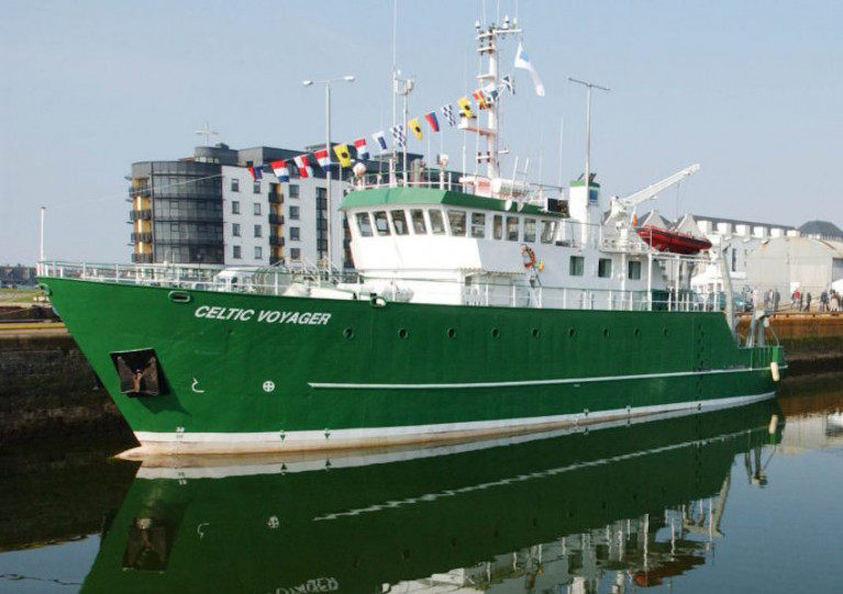
After 25 years in service with the Marine Institute, the RV Celtic Voyager is now going up for sale.

The RV Celtic Voyager came into service in 1997 as Ireland’s first custom-built multi-purpose research vessel. It has been central to the Marine Institute’s work and research, enabling Ireland as a nation to engage in high-quality marine science and to actively contribute to international research programmes.

The vessel has served the nation well over the past quarter of a century, providing marine scientists, researchers and crew members with many years of experience at sea and enabling us to deepen our ocean knowledge.

The research vessel has played an essential role in fisheries scientific research, and a vital role in seabed mapping in Irish waters as part of the INFOMAR programme.

More than 200 shipwrecks around the coast of Ireland, including the RMS Lusitania, have been mapped by the Celtic Voyager. In 2007, the survey of Galway Bay revealed for the first time a detailed seafloor and geology of the bay, confirming the location of the Galway Bay Fault.

The vessel is currently lying afloat in Howth, Co Dublin. Interested parties can contact the sole agent, Hanseatic Offshore Brokers (details below), to register interest and to arrange viewing. The closing date for registration of interest is Friday 1 September 2023.

Hanseatic Offshore Brokers GmbH
Große Bleichen 32,
20354 Hamburg, Germany
Mobile: +49 173 1 555 351
Email: [email protected]
Web: www.hanseaticoffshore.com

Published in Marine Science

The Irish Centre for Research in Applied Geosciences (iCRAG) at University College Dublin will undertake its InStor survey to acquire data for leakage monitoring for carbon capture and storage in the North Celtic Sea next month.

Supporting ongoing research at iCRAG, the survey’s aim “is to investigate and characterise the existing seabed morphologies which are related to passive and active seepage of fluids, such as pockmarks and mounds, and to provide new high-resolution geophysical datasets along with geochemical data, which will be used to create an integrated baseline geological model and form the basis for understanding the current status of complex processes in the survey area.”

Weather depending, the survey will be carried out between 19 and 26 March by the RV Celtic Voyager (callsign EIQN) which will display appropriate lights and signals. Work will be performed in accordance with safe operating practices regarding MMO procedures and cognisant of fishing gear.

Coordinates of the survey area as well as contact details are included in Marine Notice No 13 of 2022, which is attached below.

Published in News Update

The Department of Transport advises that an analogue survey consisting of multibeam, side-scan sonar and magnetometer will be carried out off the South Coast of Ireland by the Marine Institute on behalf of Providence Resources from Saturday 23 to Sunday 31 October, weather permitting.

In addition to the analogue survey, seabed samples and camera imagery will be acquired at approximately 10 stations in the survey area.

The survey will be conducted in Block 48/24 Barryroe, in the North Celtic Basin, around 45–50km from the south coast of Ireland, and will be undertaken by the RV Celtic Voyager (callsign EIQN). The vessel will be towing a side-scan sonar and magnetometer from time to time with cables of up to 300m long.

As this vessel will be restricted in its ability to manoeuvre when surveying, other vessels are requested to keep a wide berth. The vessel will display appropriate lights and signals.

For details of coordinates of the survey area, see Marine Notice No 55 of 2021 which is available to download below.

Published in News Update

The next SeaMonitor survey will be carried out by the RV Celtic Voyager in the North Channel from tomorrow, Wednesday 29 September.

This latest stage of the project aims to deploy 80 acoustic listening stations (ALSs) across the North Channel from Malin Head in Ireland to the Isle of Islay in Scotland between over four days, concluding on Saturday 2 October.

These stations will allow recording the presence of tagged marine wildlife including salmon, seals, cetaceans, basking shark and skate species, and provide evidence for conservation measures.

The SeaMonitor project is already ahead of schedule, as previously reported on Afloat.ie, with researchers from Nova Scotia in Canada carrying out expert field work using large-scale acoustic telemetry equipment.

This week’s survey operations will be carried out during daylight hours to facilitate a safe deployment of acoustic receivers on the seabed. The RV Celtic Voyager (callsign EIQN) will display appropriate lights and signals throughout.

For details on relevant locations and contact information, see Marine Notice No 54 of 2021 which can be downloaded below.

Published in Marine Science

Applications are currently being accepted for ship time in on Ireland’s national marine science research vessels in 2022 and 2023.

In addition to the RV Celtic Explorer and RV Celtic Voyager, placements will also be available on the new RV Tom Crean which is expected to be operational in mid 2022 and will replace the RV Celtic Voyager.

The ROV Holland I as well as the Marine Institute’s Slocum Glider submersibles Laochra na Mara and Aisling na Mara are also offered.

Applications must be submitted using Research Vessel Operations’ online Survey Planning System by Thursday 16 September. Contact Research Vessel Operations at [email protected] to obtain a username and password.

Each application will be reviewed and the applicant will be informed as soon as possible whether the ship time they requested is available. If the requested timing is not available, alternative dates may be offered.

The Vessel Charter Guidelines should be read carefully before submitting the ship-time application form.

Further information, technical specification and contact details for the Slocum Gliders are available on the Glider webpage.

Applicants may seek grant-aid to cover all or part of the vessel charter costs for Research Surveys or Ship-Based Training Programmes in 2022. The closing date for receipt of grant-aid applications is 5pm on Thursday 16 September.

Applicants for ship-based training are advised to consult with the Strategic Marine Alliance for Research and Training (SMART) at [email protected]. SMART aims to standardise and optimise ship-based training for undergraduate and post-graduate students and develop nationally accredited ship-based training activities for national higher education.

Applicants are advised that survey schedules can change during the year; contact Research Vessel Operations at [email protected] to check whether any survey slots remain for 2021 and/or request to be notified if any dates become available.

Published in Marine Science

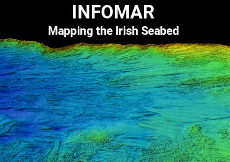
The latest Marine Notice from the Department of Transport advises that INFOMAR will undertake a hydrographic and geographic survey operation in the Celtic Sea and Atlantic Ocean for six months from this April.

The massive operation will involve research vessels from Geological Survey Ireland (Keary, Geo, Lir, Gale and Mallet) and the Marine Institute (Celtic Voyager and Celtic Explorer) in a variety of surveys — along the South-West Coast from Roaringwater Bay to Kilkee, and offshore south of Mizen Head and between Kerry Head and the Aran Islands.

All vessels will be listening on VHF Channel 16 throughout the survey, and will display appropriate lights and markers. The RVs Celtic Voyager and Celtic Explorer will also be towing a magnetometer sensor with a single cable up to 200m in length, and a moving vessel profiler cable of variable length up to 200m.

Full details of the surveys, including dates, maps and coordinates, can be found in Marine Notice No 10 of 2021, a PDF of which can be downloaded below.

Published in News Update

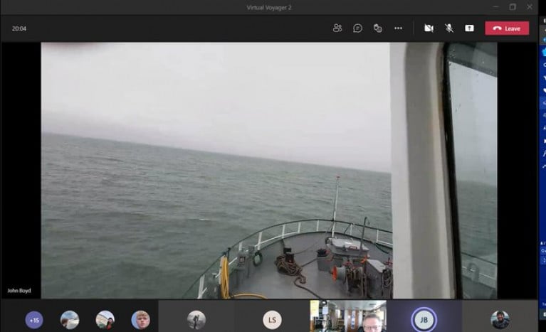
RV Celtic Voyager of the Marine Institute, Ireland's national agency for marine research, development and innovation, has been working in south Dublin Bay this week, writes Jehan Ashmore.

The 31.4m ship to be replaced next year by a Spanish newbuild, to be named the RV Tom Crean (52.8m), has since the start of this week carried out ship-based training albeit for 'land-based' marine biology students given the lock-down restrictions.

Despite that, Dr. Simon Berrow and Mr. John Boyd of the Galway-Mayo Institute of Technology (GMIT) have been 'live-streaming' from on board the RV Celtic Voyager to their students at home.

According to a tweet on the M.I. website, the work has been an excellent run down of what's involved in offshore surveys. As close as the real thing as you can get, less the swell and the rain! 

The scene was observed by Afloat as the RV Celtic Voyager was in a south Dublin Bay prior to returning to the temporary base of Dun Laoghaire Harbour this afternoon. According to Met.ie, gale force 8-9 winds forecast tonight on the Irish Sea and Storm Force 10 off Wicklow Head and further south. 

Already in port at Carlisle Pier, the UK registered, Spanish owned trawler Magan D which had been adrift that arrived at the weekend. Also berthed but since yesterday, Dublin Array's proposed wind-farm project related ship, Fugro Mercator having been busy on geophysical surveys.

The GMIT has a Marine and Freshwater Research Centre where among the specialist research staff is Dr Simon Berrow, responsible for Marine mammals, seabirds and Environmental impact. Also on board, Mr. John Boyd's specialising in fisheries, seagoing operations and maritime training.

The vessels six day (at 'sea') training programme is scheduled to end this Saturday.

While today, the M.I. other larger research vessel, RV Celtic Explorer (65.5m) is working in waters considerably further offshore in the North Atlantic Ocean.

Afloat tracked RV Celtic Explorer some 400 nautical miles offshore of the western seaboard to the ship's homeport of Galway.

The deployment of the vessel is to support an Ocean & Climate survey across south Rockall Trough with the vessel due back to its homeport in around a month's time.

Published in Marine Science

The latest Marine Notice from the Department of Transport advises that a survey to investigate the use of fibre-optic cables in site investigations will be carried out in the North Irish Sea next month.

This survey from 16-25 March is being carried out in support of ongoing research at the Irish Centre for Research in Applied Geosciences (iCRAG).

The equipment and techniques to be used include:

  • Distributed Acoustic Sensing (DAS) using fibre-optic cables: A 1000m length of fibre optic cable will be placed temporarily on the seabed in order to carry out the survey. The position of the cable will be marked using surface buoys.
  • OBS deployment: Two ocean bottom seismometers will be deployed and will remain in position until retrieval at the end of the survey.
  • Sparker seismic profiling: This will be carried out as mobile work towing a transducer a short distance behind the work vessel.

The survey will be conducted by the RV Celtic Voyager (Callsign EIQN) and Fionn Mac Cumhaill (Callsign EIDN2). The two vessels will work close by each other and the latter is assisting with marine mammal observer work.

The vessels will display appropriate lights and signals. Mariners should note that seismic surveying using DAS equipment will be performed during daylight hours.

Further details including relevant coordinates can be found in Marine Notice No 08 of 2021, a PDF of which can be downloaded below.

Published in Marine Warning

The Loughs Agency advises that it will carry out the SeaMonitor-EU Interreg Project (Survey CV21003) from Saturday 27 February to Friday 5 March.

The survey is being carried out in the North Channel in support of EU InterregVA project SeaMonitor.

A total of 108 Acoustic Listening Stations (ALS) are planned to be deployed at different locations covering a total of 63km between Malin Head in Co Donegal and Portnahaven on the Isle of Islay in western Scotland.

The first ALS on the Irish side is located 0.5 nautical miles from Inishtralhull Island at a depth of 20m. On the Scottish side, the first ALS is located 0.5nm from the shore at depths of 20-30m.

The survey will be conducted by the RV Celtic Voyager (Callsign EIQN) which will display appropriate lights and signals. Operations will be carried out during daylight hours to facilitate a safe deployment of acoustic receivers on the sea bed.

Further details including relevant coordinates can be found in Marine Notice No 07 of 2021, a PDF of which can be downloaded below.

Published in Marine Warning

The next legs of the Mobility of Sediment Waves and Sand Banks in the Irish Sea (MOVE) Survey begin tomorrow, Wednesday 23 September, according to the latest Marine Notice from the Irish Maritime Administration.

As previously reported on Afloat.ie, the survey is being carried out in support of ongoing research at the Irish Centre for Research in Applied Geosciences (iCRAG).

The latest two legs of the survey will take place from 23-28 September and from 7-19 October in the south Irish Sea.

Works will be carried out by the RV Celtic Voyager (callsign EQIN) using a variety of equipment and techniques, including ADCP, multibeam sonar and sediment sampling.

All works will be performed on a 24-hour schedule and the vessel will display appropriate lights and signals.

Details of all works entailed and the survey areas are included in Marine Notice No 43 of 2020, a PDF of which is available to download below.

Published in News Update
Page 1 of 5

General Information on using Waterways Ireland inland navigations

Safety on the Water

All users of the navigations are strongly recommended to make themselves aware of safety on the water for whatever activity they are involved in and to read the advice offered by the various governing bodies and by:

The Dept. of Transport, Ireland: www.gov.ie/transport and The Maritime and Coastguard Agency, UK, The RNLI – Water Safety Ireland for information in terms of drowning prevention and water safety.

Registration of Vessels

All vessels using the Shannon Navigation, which includes the Shannon-Erne Waterways and the Erne System must be registered with Waterways Ireland. Only open undecked boats with an engine of 15 horsepower or less on the Shannon Navigation, and vessels of 10 horsepower or less on the Erne System, are exempt. Registration is free of charge.

Craft registration should be completed online at: https://www.waterwaysireland.org/online-services/craft-registration

Permits for use of the Grand and Royal Canals and the Barrow Navigation

All vessels using the Grand and Royal Canals and the Barrow Navigation must display appropriate valid Permit(s) i.e A Combined Mooring and Passage Permit (€126) and if not intending to move every five days, an Extended Mooring Permit (€152).

Permit applications should be completed online at: https://www.waterwaysireland.org/online-services/canal-permits

Passage on the Royal and Grand Canals – Dublin Area

For boat passage through the locks east of Lock 12 into / out of Dublin on either the Royal or Grand Canals, Masters are requested to contact the Waterways Ireland Eastern Regional Office (M-F 9.30am-4.30pm) on tel: +353(0)1 868 0148 or email [email protected] prior to making passage in order to plan the necessary lock-keeping assistance arrangements.

On the Grand Canal a minimum of two days notice prior to the planned passage should be given, masters should note that with the exception of pre-arranged events, a maximum of 2 boats per day will be taken through the locks, travelling either east or west.

Movements in or out of the city will be organised by prior arrangement to take place as a single movement in one day. Boaters will be facilitated to travel the system if their passage is considered to be safe by Waterways Ireland and they have the valid permit(s) for mooring and passage.

Newcomen Lifting Bridge

On the Royal Canal two weeks’ notice of bridge passage (Newcomen Lifting Bridge) is required for the pre-set lift date, and lock assistance will then also be arranged. A minimum of 2 boats is required for a bridge lift to go ahead.

Waterways Ireland Eastern Regional Office (Tel: +353(0)1 868 0148 or [email protected] ) is the point of contact for the bridge lift.

A maximum number of boats passing will be implemented to keep to the times given above for the planned lifts (16 for the Sat / Sun lifts & 8 for the weekday lifts). Priority will be given on a first come first served basis.

On day of lift, boaters and passengers must follow guidance from Waterways Ireland staff about sequence of passage under bridge & through Lock 1, and must remain within signed and designated areas.

Events Held on the Waterways

All organised events taking place on the waterways must have the prior approval of Waterways Ireland. This is a twelve week process and application forms must be accompanied with the appropriate insurance, signed indemnity and risk assessment. The application should be completed on the Waterways Ireland events page at :

https://www.waterwaysireland.org/online-services/event-approval

Time Limits on Mooring in Public Harbours

On the Shannon Navigation and the Shannon-Erne Waterway craft may berth in public harbours for five consecutive days or a total of seven days in any one month.

On the Erne System, revised Bye Laws state that: No master or owner shall permit a vessel, boat or any floating or sunken object to remain moored at or in the vicinity of any public mooring, including mooring at any other public mooring within 3 kilometres of that location, for more than 3 consecutive days and shall not moor at that same mooring or any other public mooring within 3 kilometres of that location within the following 3 consecutive days without prior permission by an authorised official.

Winter Mooring on the Shannon Navigation and Shannon Erne Waterway

Winter mooring may be availed of by owners during the period 1 Nov to 31 Mar by prior arrangement and payment of a charge of €63.50 per craft. Craft not availing of Winter Mooring must continue to comply with the “5 Day Rule”. Winter Mooring applications should be completed online at : https://www.waterwaysireland.org/online-services/winter-moorings-booking

Owners should be aware that electricity supply and water supply to public moorings is disconnected for the winter months. This is to protect against frost damage, to reduce running costs and to minimise maintenance requirements during the winter months.

Vessel owners are advised that advance purchasing of electricity on the power bollards leading up to the disconnection date should be minimal. Electricity credit existing on the bollards will not be recoverable after the winter decommissioning date. Both services will be reinstated prior to the commencement of the next boating season.

Smart Cards

Waterways Ireland smart cards are used to operate locks on the Shannon Erne Waterway, to access the service blocks, to use the pump-outs along the navigations, to avail of electrical power at Waterways Ireland jetties.

Berthing in Public Harbours

Masters are reminded of the following:

  • Equip their vessel with mooring lines of appropriate length and strength and only secure their craft to mooring bollards and cleats provided for this purpose.
  • Ensure the available berth is suitable to the length of your vessel, do not overhang the mooring especially on finger moorings on floating pontoon moorings.
  • Ensure mooring lines, electric cables and fresh water hoses do not create a trip hazard on public jetties for others users.
  • Carry sufficient fenders to prevent damage to your own vessel, other vessels and WI property.
  • Allow sufficient space between your vessel and the vessel ahead /astern (c.1m) for fire safety purposes and /or to recover somebody from the water.
  • Do not berth more than two vessels side by side and ensure there is safe access/egress at all times between vessels and onto the harbour itself.
  • Do not berth in such a way to prevent use of harbour safety ladders, slipways or pump-outs.
  • Do not allow the bow of your vessel to overhang the walkway of a floating mooring thus creating a hazard for others with an overhanging anchor or bow fendering.
  • Animals are not allowed to be loose or stray at any time.
  • Harbour and jetty infrastructure such as railings, power pedestals, fresh water taps, electric light poles, safety bollards, ladders etc are not designed for the purpose of mooring craft , they will not bear the strain of a vessel and will be damaged.
  • At Carrybridge on the Erne System, Masters of vessels are not permitted to use stern on mooring. Masters of vessels must use the mooring fingers for mooring of vessels and for embarkation / disembarkation from vessels.

Passenger Vessel Berths

Masters of vessels should not berth on passenger vessel berths where it is indicated that an arrival is imminent. Passenger vessels plying the navigations generally only occupy the berths to embark and disembark passengers and rarely remain on the berths for extended periods or overnight.

Lock Lead-in Jetties

Lead-in jetties adjacent to the upstream and downstream gates at lock chambers are solely for the purpose of craft waiting to use the lock and should not be used for long term berthing.

Vessel Wake

Vessel wake, that is, the wave generated by the passage of the boat through the water, can sometimes be large, powerful and destructive depending on the hull shape and engine power of the vessel. This wake can be detrimental to other users of the navigation when it strikes their craft or inundates the shoreline or riverbank. Masters are requested to frequently look behind and check the effect of their wake / wash particularly when passing moored vessels, on entering harbours and approaching jetties and to be aware of people pursuing other activities such as fishing on the riverbank.

Speed Restriction

A vessel or boat shall not be navigated on the Shannon Navigation at a speed in excess of 5 kph when within 200 metres of a bridge, quay, jetty or wharf, when in a harbour or canal or when passing within 100 metres of a moored vessel or boat.

Vessels navigating the Shannon-Erne Waterway should observe the general 5 kph speed limit which applies along the waterway. This is necessary in order to prevent damage to the banks caused by excessive wash from vessels.

Vessels navigating the Erne System should observe the statutory 5kt / 6mph / 10kph speed limit areas.

A craft on the Royal and Grand canals shall not be navigated at a speed in excess of 6km per hour.

A craft on the Barrow Navigation shall not be navigated at a speed in excess of 11km per hour except as necessary for safe navigation in conditions of fast flow.

Bank Erosion

Narrow sections of all the navigations are particularly prone to bank erosion due to the large wash generated by some craft. Masters are requested to be vigilant and to slow down to a speed sufficient to maintain steerage when they observe the wash of their craft inundating the river banks.

Unusual Waterborne Activity

Unusual waterborne vessels may be encountered from time to time, such as, hovercraft or amphibious aircraft / seaplanes. Masters of such craft are reminded to apply the normal “Rule of the Road” when they meet conventional craft on the water and to allow extra room to manoeuvre in the interest of safety.

Sailing Activity

Mariners will encounter large numbers of sailing dinghies from late June to August in the vicinity of Lough Derg, Lough Ree and Lower Lough Erne. Sailing courses are marked by yellow buoys to suit weather conditions on the day. Vessels should proceed at slow speed and with due caution and observe the rules of navigation when passing these fleets, as many of the participants are junior sailors under training.

Rowing

Mariners should expect to meet canoes and vessels under oars on any part of the navigations, but more so in the vicinity of Athlone, Carrick-on-Shannon, Coleraine, Enniskillen and Limerick. Masters are reminded to proceed at slow speed and especially to reduce their wash to a minimum when passing these craft as they can be easily upset and swamped due to their very low freeboard and always be prepared to give way in any given traffic situation.

Canoeing

Canoeing is an adventure sport and participants are strongly recommended to seek the advice of the sport’s governing bodies i.e Canoeing Ireland and the Canoe Association of Northern Ireland, before venturing onto the navigations.

Persons in charge of canoes are reminded of the inherent danger to these craft associated with operating close to weirs, sluice gates, locks and other infrastructure particularly when rivers are in flood and large volumes of water are moving through the navigations due to general flood conditions or very heavy localised precipitation e.g. turbulent and broken water, stopper waves. Shooting weirs is prohibited without prior permission of Waterways Ireland.

Canoeists should check with lockkeepers prior entering a lock to ensure passage is done in a safe manner. Portage is required at all unmanned locks.

Canoe Trail Network – "Blueways"

Masters of powered craft are reminded that a canoe trail network is being developed across all navigations and to expect more organised canoeing along these trails necessitating slow speed and minimum wash when encountering canoeists, rowing boats etc

Rockingham and Drummans Island Canals – Lough Key

It is expected that work on Rockingham and Drummans Island Canals on Lough Key will be completed in 2021. Access to these canals will be for non-powered craft only, eg canoes, kayaks, rowing boats.

Fast Powerboats and Personal Watercraft (Jet Skis)

Masters of Fast Powerboats (speed greater than 17kts) and Personal Watercraft (i.e.Jet Skis) are reminded of the inherent dangers associated with high speed on the water and especially in the confines of small bays and narrow sections of the navigations. Keeping a proper look-out, making early alterations to course and /or reducing speed will avoid conflict with slower vessels using the navigation. Personal Watercraft are not permitted to be used on the canals.

Towing Waterskiers, Wakeboarders, Doughnuts etc

Masters of vessels engaged in any of these activities are reminded of the manoeuvring constraints imposed upon their vessel by the tow and of the added responsibilities that they have to the person(s) being towed. These activities should be conducted in areas which are clear of conflicting traffic. It is highly recommended that a person additional to the master be carried to act as a “look-out” to keep the tow under observation at all times.

Prohibition on Swimming

Swimming in the navigable channel, particularly at bridges, is dangerous and is prohibited due to the risk of being run over by a vessel underway in the navigation.

Age Restrictions on operating of powered craft

In the Republic of Ireland, Statutory Instrument 921 of 2005 provides the legal requirements regarding the minimum age for operating of powered craft. The Statutory Instrument contains the following requirements:

- The master or owner of a personal watercraft or a fast power craft shall take all reasonable steps to ensure that a person who has not attained the age of 16 years does not operate or control the craft

- The master or owner of a pleasure craft powered by an engine with a rating of more than 5 horse power or 3.7 kilowatts shall take all reasonable steps to ensure that a person who has not attained the age of 12 years does not operate or control the craft.

Lifejackets and Personal Flotation Devices (PFDs)

Lifejackets and PFD’s are the single most important items of personal protective equipment to be used on a vessel and should be worn especially when the vessel is being manoeuvred such as entering / departing a lock, anchoring, coming alongside or departing a jetty or quayside.

In the Republic of Ireland, Statutory Instrument 921 of 2005 provides the legal requirements regarding the wearing of Personal Flotation Devices. The Statutory Instrument contains the following requirements:

- The master or owner of a pleasure craft (other than a personal watercraft) shall ensure, that there are, at all times on board the craft, sufficient suitable personal flotation devices for each person on board.

- A person on a pleasure craft (other than a personal watercraft) of less than 7 metres length overall shall wear a suitable personal flotation device while on board an open craft or while on the deck of decked craft, other than when the craft is made fast to the shore or at anchor.

- The master or owner of a pleasure craft (other than a personal watercraft) shall take all reasonable steps to ensure that a person who has not attained the age of 16 years complies with paragraph above.

- The master or owner of a pleasure craft (other than a personal watercraft), shall take all reasonable steps to ensure that a person who has not attained the age of 16 years wears a suitable personal flotation device while on board an open craft or while on the deck of a decked craft other than when it is made fast to the shore or at anchor.

- The master or owner of a pleasure craft (other than a personal watercraft) shall take all reasonable steps to ensure that a person wears a suitable personal flotation device, at all times while – (a) being towed by the craft, (b) on board a vessel or object of any kind which is being towed by the craft.

Further information is available at: http://www.irishstatutebook.ie/eli/2005/si/921/made/en/print

Firing Range Danger Area – Lough Ree

The attention of mariners is drawn to the Irish Defence Forces Firing Range situated in the vicinity of buoys No’s 2 and 3, on Lough Ree on the Shannon Navigation. This range is used regularly for live firing exercises, throughout the year, all boats and vessels should stay clear of the area marked with yellow buoys showing a yellow "X" topmark and displaying the word "Danger".

Shannon Navigation, Portumna Swing Bridge Tolls

No attempt should be made by Masters’ of vessels to pay the bridge toll while making way through the bridge opening. Payment will only be taken by the Collector from Masters when they are secured alongside the jetties north and south of the bridge.

Navigating from Killaloe to Limerick on the Shannon Navigation

The navigation from Killaloe to Limerick involves passage through Ardnacrusha locks, the associated headrace and tailrace and the Abbey River into Limerick City. Careful passage planning is required to undertake this voyage. Considerations include: lock passage at Ardnacrusha, water flow in the navigation, airdraft under bridges on Abbey River in Limerick, state of tide in Limerick

Users are advised to contact the ESB Ardnacrusha hydroelectric power station (00353 (0)87 9970131) 48 hours in advance of commencing their journey to book passage through the locks at Ardnacrusha. It is NOT advised to undertake a voyage if more than one turbine is operating (20MW), due to the increased velocity of flow in the navigation channel, which can be dangerous. To ascertain automatically in real time how many turbines are running, users can phone +353 (0)87 6477229.

For safety reasons the ESB has advised that only powered craft with a capacity in excess of 5 knots are allowed to enter Ardnacrusha Headrace and Tailrace Canals.

Passage through Sarsfield Lock should be booked on +353-87-7972998, on the day prior to travel and it should be noted also that transit is not possible two hours either side of low water.

A Hydrographic survey in 2020 of the navigation channel revealed that the approach from Shannon Bridge to Sarsfield Lock and the Dock area has silted up. Masters of vessels and water users are advised to navigate to the Lock from Shannon bridge on a rising tide one or two hours before High Tide.

Lower Bann Navigation

The attention of all users is drawn to the “Users Code for the Lower Bann”, in particular to that section covering “Flow in the River” outlining the dangers for users both on the banks and in the navigation, associated with high flow rates when the river is in spate. Canoeists should consult and carry a copy of the “Lower Bann Canoe Trail” guide issued by the Canoe Association of Northern Ireland. Users should also contact the DfI Rivers Coleraine, who is responsible for regulating the flow rates on the river, for advisory information on the flow rates to be expected on any given day.

DfI Rivers Coleraine. Tel: 0044 28 7034 2357 Email: [email protected]

Lower Bann Navigation – Newferry – No wake zone

A No Wake Zone exists on the Lower Bann Navigation at Newferry. Masters of vessels are requested to proceed at a slow speed and create no wake while passing the jetties and slipways at Newferry.

Overhead Power Lines (OHPL) and Air draft

All Masters must be aware of the dangers associated with overhead power lines, in particular sailing vessels and workboats with cranes or large air drafts. Voyage planning is a necessity in order to identify the location of overhead lines crossing the navigation.

Overhead power line heights on the River Shannon are maintained at 12.6metres (40 feet) from Normal Summer level for that section of navigation, masters of vessels with a large air draft should proceed with caution and make additional allowances when water levels are high.

If a vessel or its equipment comes into contact with an OHPL the operator should NOT attempt to move the vessel or equipment. The conductor may still be alive or re-energise automatically. Maintain a safe distance and prevent third parties from approaching due to risk of arcing. Contact the emergency services for assistance.

Anglers are also reminded that a minimum ground distance of 30 metres should be maintained from overhead power lines when using a rod and line.

Submarine Cables and Pipes

Masters of vessels are reminded not to anchor their vessels in the vicinity of submarine cables or pipes in case they foul their anchor or damage the cables or pipes. Look to the river banks for signage indicating their presence.

Water Levels - Precautions

Low Water Levels:

When water levels fall below normal summer levels masters should be aware of:

Navigation

To reduce the risk of grounding masters should navigate on or near the centreline of the channel, avoid short cutting in dog-legged channels and navigating too close to navigation markers.

Proceeding at a slow speed will also reduce “squat” effect i.e. where the vessel tends to sit lower in the water as a consequence of higher speed.

Slipways

Reduced slipway length available under the water surface and the possibility of launching trailers dropping off the end of the concrete apron.

More slipway surface susceptible to weed growth requiring care while engaged in launching boats, from slipping and sliding on the slope. Note also that launching vehicles may not be able to get sufficient traction on the slipway once the craft is launched to get up the incline.

Bank Erosion

Very dry riverbanks are more susceptible to erosion from vessel wash.

Lock Share

Maximising on the number of vessels in a lock will ensure that the total volume of water moving downstream is decreased. Lock cycles should be used for vessels travelling each way.

High Water Levels:

When water levels rise above normal summer level masters should be aware of:

Navigation

Navigation marks will have reduced height above the water level or may disappear underwater altogether making the navigable channel difficult to discern.

In narrow sections of the navigations water levels will tend to rise more quickly than in main streams and air draft at bridges will likewise be reduced.

There will also be increased flow rates particularly in the vicinity of navigation infrastructure such as bridges, weirs, locks etc where extra care in manoeuvring vessels will be required.

Harbours and Jetties

Due care is required in harbours and at slipways when levels are at or near the same level as the harbour walkways' as the edge will be difficult to discern especially in reduced light conditions. It is advised that Personal Flotation Devices be worn if tending to craft in a harbour in these conditions.

Slipways

Slipways should only be used for the purpose of launching and recovering of water craft or other objects from the water. Before using a slipway it should be examined to ensure that the surface has sufficient traction/grip for the intended purpose such as launching a craft from a trailer using a vehicle, that there is sufficient depth of water on the slipway to float the craft off the trailer before the concrete apron ends and that the wheels of the trailer do not drop off the edge of the slipway. That life-saving appliances are available in the vicinity, that the vehicle is roadworthy and capable of coping with the weight of the trailer and boat on the incline. It is recommended that slipway operations are conducted by two persons.

Caution to be Used in Reliance upon Aids to Navigation

The aids to navigation depicted on the navigation guides comprise a system of fixed and floating aids to navigation. Prudent mariners will not rely solely on any single aid to navigation, particularly a floating aid to navigation. With respect to buoys, the buoy symbol is used to indicate the approximate position of the buoy body and the ground tackle which secures it to the lake or river bed. The approximate position is used because of the practical limitations in positioning and maintaining buoys in precise geographical locations. These limitations include, but are not limited to, prevailing atmospheric and lake/river conditions, the slope of and the material making up the lake/river bed, the fact that the buoys are moored to varying lengths of chain, and the fact that the buoy body and/or ground tackle positions are not under continuous surveillance. Due to the forces of nature, the position of the buoy body can be expected to shift inside and outside the charted symbol.

Buoys and perches are also moved out of position or pulled over by those mariners who use them to moor up to instead of anchoring. To this end, mariners should always monitor their passage by relating buoy/perch positions with the published navigation guide. Furthermore, a vessel attempting to pass close by always risks collision with a yawing buoy or with the obstruction that the buoy or beacon/perch marks.

Masters of Vessels are requested to use the most up to date Navigation guides when navigating on the Inland Waterways.

Information taken from Special Marine Notice No 1 of 2023