Menu

Ireland's sailing, boating & maritime magazine

Inland afloat headers


Displaying items by tag: River Lee

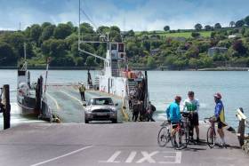
#ferries - Owners of the River Lee car ferry service in Cork harbour, the Irish Examiner reports, have told Cork County Council they don't believe it's economically viable to put on a second ferry at peak evening times.

Doyle Shipping Group (also operators of Cross River Ferries) contacted Paraic Lynch, municipal officer for the Cobh/Glanmire Municipal District Council, to tell him the news after a number of councillors petitioned the company to beef up their service from Glenbrook, on the Passage West side to Carrigaloe, on the Cobh side.

Councillors living in the Cobh area are particularly concerned about the length of time it is taking people to get across the harbour from the Glenbrook side during the evening rush-hour period.

Mr Lynch told the councillors that Doyle Shipping had contacted him to say they didn't see it as viable to operate two ferries at that time. However, he added that the company says it will continue to monitor the situation, especially when major work gets underway on the €100m upgrade of the Jack Lynch Tunnel/Dunkettle interchange later this year.

Councillors are particularly concerned about that as they believe it will drive more motorists to use the cross-river ferry to avoid delays at the northern side of the tunnel as the upgrade works get underway.

For further comments by councillors following the decision announced by the shipping group click here.

Published in Ferry

Dear Editor,

I moved to Inchigeelagh, Co Cork last October. My first Summer here is being filled with admiring all of the beautiful scenery.

I've got a bug about sailing in the local lake that just won't go away, I'm sure you understand! :)

The trouble is that I've no idea about how to go about it, where to enquire, what kind of boat I'd be allowed to take out, what size engine is allowed etc.

It's not for fishing, just to go sail in circles with the kids on a nice day and perhaps sleep on board for the night before going back home after a day or two.

Please tell me it's allowed and easy to go about?

Any help would be greatly appreciated,

Thanking You,

Con

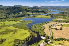
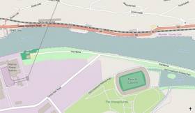
Afloat.ie replies: The lovely Lough Allua on the upper River Lee above Inchigeelagh has been enlarged by the Hydro-electric dam at Carrigadrohid to provide an impressive lake which is renowned for its angling (pike fishing especially), and it is also used by kayakers - both for the pleasures of the lake itself, and as part of the transit of the River Lee from source to sea.

However, the presence of old tree stumps hidden just below the surface – often a hazard when water-levels have been raised – may make sailing hazardous in some locations. We suggest that Con contact Eddie English of SailCork, who would know of any sailing enthusiasts in the neighbourhood – [email protected]

Published in Cork Harbour
Tagged under

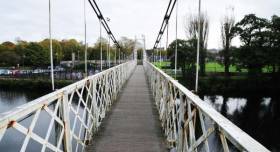
#InlandWaterways - An urgent health-and-safety audit of Shakey Bridge in Cork have been called for amid fears the iconic city structure could be one shake from collapse.

As the Irish Examiner writes, historian and city councillor Kieran McCarthy said it was shocking to see one of the city’s best-known landmarks and tourist attractions — the city’s only suspension bridge, famous for its wobble — decay to such a dangerous state.

“Urgent action is required before we have to make the sad call to close it off to the public completely,” he said. “That would be a shame.”

As talks continue over the city’s 2019 budget, he plans to ask the city council’s chief executive, Ann Doherty, to urgently identify and set aside funding to repair the bridge which was officially opened 90 years ago.

Daly’s Bridge is a 48m-span wrought-iron suspension pedestrian bridge which was built by a London-based company over the northern channel of the River Lee in 1927 to a design by former Cork City architect Stephen Farrington.

To read much more on this story including photos of the rusting bridge's lattice-work structure, click here.

Published in Inland Waterways

#portofcork - Along the River Lee is where an expected stink is to eminate in the coming days as the Port of Cork dredges the riverbed.

As the Evening Echo writes, every three years the Port of Cork carries out dredging work in the harbour and the quaysides to maintain the shipping channel. The work disturbs the riverbed, dragging up sediment and releasing gases like hydrogen sulphide. While the gases are safe, they are responsible for the eggy smell that could hang over the river in the coming days.

In 2014, Barrack Street, MacCurtain Street, Shandon, North Main Street, Patrick’s Street and Merchant’s Quay were all affected by the smell as a result of dredging. However, it was thought the lack ro rain and warm temperatures exacerbated the situation at that time.

The current dredging scheme is expected to last until the end of October but the city quays portion is planned to be completed by October 9, limiting the smell in the city centre. The Port of Cork said it is taking measures to limit the impact.

For more on the dredging by clicking here. 

Published in Dredging
Tagged under

#RiverLee - Divers have found a car submerged in the River Lee in Cork just hours after it was seen entering the water this morning (Friday 6 May).

BreakingNews.ie reports that a member of the public spotted the vehicle near the Lee Rowing Club with its boot sticking out of the water around 6am, prompting an immediate search and rescue response.

The car was subsequently located after a search of the river and divers from Haulbowline are assessing the scene, as RTÉ News reports.

In other news, a young tourist is recovering after he was swept onto rocks by an unexpected wave at Doolin in Co Clare yesterday (Thursday 5 May).

The 25-year-old American sustained multiple injuries after the wave knocked him off the shoreline at the popular beauty spot, according to BreakingNews.ie.

Published in Cork Harbour
Tagged under

#Cork - The search for a homeless man seen falling into the River Lee in Cork city ended in his arrest, as The Irish Times reports.

Valentia Coast Guard co-ordinated the search and rescue operation for the man, who was witnessed falling into the water after 7am yesterday morning (Saturday 21 March).

However the man was quickly discovered by emergency personnel on a support beneath Parnell Bridge, refusing to come out.

The Irish Times has more on the story HERE.

Published in News Update

#Drowning - Three drownings over the weekend have underlined the importance of safety on the water during the current sunny spell.

In Galway, residents of Moycullen were mourning the loss of a Lithuanian man who drowned while swimming with friends in Ballyquirke Lake on Saturday evening 8 June, according to Galway Bay FM.

And RTÉ News reports of a similar incident in Cork in the early hours of this morning 10 June, in which a 21-year-old man drowned after getting into difficulties in the River Lee near Ballincollig.

The young man is also believed to have been swimming with friends after another hot day across the country, according to The Irish Times.

Elsewhere in Cork, RTÉ News says a 17-year-old has died after drowning in the River Blackwater.

Earlier it was reported that the teen was in a serious condition after getting into difficulties while swimming with friends at a bathing spit known locally as Lisheen Bridge, and had been in the water for some time before he was recovered.

Published in Water Safety

#COBH TITANIC 100  - Following President Michael D. Higgins visit to Cobh to commemorate the centenary call of RMS Titanic to Queenstown, the town yesterday hosted a Naval Service review that included the Royal Navy's HMS Mersey.

The President as supreme commander of the Defence Forces boarded the Naval Service 'flagship' L.E. Eithne which passed the guest-ship, a River class patrol vessel which headed a line of vessels which lay at anchor of Cobh's waterfront, they were the L.E. Aoife, L.E. Aisling and L.E. Niamh

The historic event which marked the pinnacle of the Titanic 100 Cobh centenary week will continue as part of a year-round programme of events. For information visit www.titanic100.ie. On the homepage the L.E. Niamh features again, where on this occasion marine photographer Jehan Ashmore captured the vessel underway as she powered her way at high-speed through a misty Dalkey Sound.

Among the many places throughout Cobh where thousands of tourists have flocked since the Balmoral docked on Monday to retrace the liner's maiden voyage, has been the White Star Line pier.

From this pier were the last passengers to depart Queenstown on board the tenders PS Ireland and PS America to the ill-fated Titanic that struck an ice-berg. On her Irish call 123 passengers were transferred to the Titanic which lay outside Cork Harbour, while 7 passengers disembarked from the liner and headed ashore.

What remains of the pier which is not accessible to the public and is in danger of collapsing, there has been calls to raise funds to save the structure, as previously reported.

Also in attendance during yesterday's historic proceedings, was the excursion passenger tender Spirit if the Isles which is operating on her second season since starting Cork Harbour cruises last year. They run between Cork city quays and downriver along the Lee to Cobh.

In the 1980's the tender then named Ingot ran excursions from Dun Laoghaire Harbour into Dublin Bay and likewise of L.E. Niamh, she too transited Dalkey Sound as part of her sightseeing tours.

Published in Titanic

#ANGLING - An "eagle-eyed" angler in Co Cork received a free eye test after his remarkable find of a wedding ring in the water last week.

Seventy-five-year-old Pat O'Flaherty spotted the €400 gold band - complete with its red box - in the River Lee, garnering him a front-page story in the Irish Examiner and a free eye test from Specsavers.

They put me in the chair and did all the tests and told me I have 20:20 vision," he said.

The owner of the ring has yet to be traced, despite much speculation as to how it ended up in the Lee in the first place. If unclaimed, O'Flaherty intends to auction the ring for charity.

In other angling news, West Cork's Courtmacsherry Angling Centre hosted members of the Bradford Sea Angling Club in the UK last weekend.

Poor weather meant that the group was restricted to inshore fishing on the Friday and Saturday, but the Sunday saw a catch of ling up to 23lbs as well as pollack, coalfish, cod, haddock and whiting.

Published in Angling

#PORT OF CORK – Global shipping giant Maersk Line recently started their first ever direct service to Ireland with a new liner service calling to the Port of Cork and sees the return of the 'banana' trade not last seen in port since the 1970's, writes Jehan Ashmore.

The older 'banana' boats or reefers that used to serve Cork may be long gone but the Danish owned Maersk Line will be operating an impressive  pool of eight large contiainerships. They will bring leading banana brands from Central American ports to Europe  with Cork being the first port of call in Europe. The liner service starts in the Mexican port of Vera Cruz and includes calls to Costa Rica, Belize, Panama before reaching Cork.

One of the vessels Maersk Nolanville (2004/26,833grt) last week docked in Ringaskiddy Deepwater Terminal, is one of  the largest of her type to be accommodated in the port. At 700m long, a beam over 30m and drawing a draft exceeding 10m the South Korean built vessel was too large to berth at the ports Tivoli Container Terminal further upriver on the Lee.

Maersk Nolanville and her fleet-mates will operate with a weekly call to Cork on Thursdays, where quayside cranes in Ringaskiddy will handle the 2,500 (TEU) capacity vessels including around 800 refrigerated containers containing perishable tropical fruits.

Asides bananas the vessels will import other cargoes, with the containerships also calling to Tilbury in the UK and Rotterdam and with exports on the return leg of the long trans-Atlantic voyage home.

Published in Port of Cork
Page 2 of 3

General Information on using Waterways Ireland inland navigations

Safety on the Water

All users of the navigations are strongly recommended to make themselves aware of safety on the water for whatever activity they are involved in and to read the advice offered by the various governing bodies and by:

The Dept. of Transport, Ireland: www.gov.ie/transport and The Maritime and Coastguard Agency, UK, The RNLI – Water Safety Ireland for information in terms of drowning prevention and water safety.

Registration of Vessels

All vessels using the Shannon Navigation, which includes the Shannon-Erne Waterways and the Erne System must be registered with Waterways Ireland. Only open undecked boats with an engine of 15 horsepower or less on the Shannon Navigation, and vessels of 10 horsepower or less on the Erne System, are exempt. Registration is free of charge.

Craft registration should be completed online at: https://www.waterwaysireland.org/online-services/craft-registration

Permits for use of the Grand and Royal Canals and the Barrow Navigation

All vessels using the Grand and Royal Canals and the Barrow Navigation must display appropriate valid Permit(s) i.e A Combined Mooring and Passage Permit (€126) and if not intending to move every five days, an Extended Mooring Permit (€152).

Permit applications should be completed online at: https://www.waterwaysireland.org/online-services/canal-permits

Passage on the Royal and Grand Canals – Dublin Area

For boat passage through the locks east of Lock 12 into / out of Dublin on either the Royal or Grand Canals, Masters are requested to contact the Waterways Ireland Eastern Regional Office (M-F 9.30am-4.30pm) on tel: +353(0)1 868 0148 or email [email protected] prior to making passage in order to plan the necessary lock-keeping assistance arrangements.

On the Grand Canal a minimum of two days notice prior to the planned passage should be given, masters should note that with the exception of pre-arranged events, a maximum of 2 boats per day will be taken through the locks, travelling either east or west.

Movements in or out of the city will be organised by prior arrangement to take place as a single movement in one day. Boaters will be facilitated to travel the system if their passage is considered to be safe by Waterways Ireland and they have the valid permit(s) for mooring and passage.

Newcomen Lifting Bridge

On the Royal Canal two weeks’ notice of bridge passage (Newcomen Lifting Bridge) is required for the pre-set lift date, and lock assistance will then also be arranged. A minimum of 2 boats is required for a bridge lift to go ahead.

Waterways Ireland Eastern Regional Office (Tel: +353(0)1 868 0148 or [email protected] ) is the point of contact for the bridge lift.

A maximum number of boats passing will be implemented to keep to the times given above for the planned lifts (16 for the Sat / Sun lifts & 8 for the weekday lifts). Priority will be given on a first come first served basis.

On day of lift, boaters and passengers must follow guidance from Waterways Ireland staff about sequence of passage under bridge & through Lock 1, and must remain within signed and designated areas.

Events Held on the Waterways

All organised events taking place on the waterways must have the prior approval of Waterways Ireland. This is a twelve week process and application forms must be accompanied with the appropriate insurance, signed indemnity and risk assessment. The application should be completed on the Waterways Ireland events page at :

https://www.waterwaysireland.org/online-services/event-approval

Time Limits on Mooring in Public Harbours

On the Shannon Navigation and the Shannon-Erne Waterway craft may berth in public harbours for five consecutive days or a total of seven days in any one month.

On the Erne System, revised Bye Laws state that: No master or owner shall permit a vessel, boat or any floating or sunken object to remain moored at or in the vicinity of any public mooring, including mooring at any other public mooring within 3 kilometres of that location, for more than 3 consecutive days and shall not moor at that same mooring or any other public mooring within 3 kilometres of that location within the following 3 consecutive days without prior permission by an authorised official.

Winter Mooring on the Shannon Navigation and Shannon Erne Waterway

Winter mooring may be availed of by owners during the period 1 Nov to 31 Mar by prior arrangement and payment of a charge of €63.50 per craft. Craft not availing of Winter Mooring must continue to comply with the “5 Day Rule”. Winter Mooring applications should be completed online at : https://www.waterwaysireland.org/online-services/winter-moorings-booking

Owners should be aware that electricity supply and water supply to public moorings is disconnected for the winter months. This is to protect against frost damage, to reduce running costs and to minimise maintenance requirements during the winter months.

Vessel owners are advised that advance purchasing of electricity on the power bollards leading up to the disconnection date should be minimal. Electricity credit existing on the bollards will not be recoverable after the winter decommissioning date. Both services will be reinstated prior to the commencement of the next boating season.

Smart Cards

Waterways Ireland smart cards are used to operate locks on the Shannon Erne Waterway, to access the service blocks, to use the pump-outs along the navigations, to avail of electrical power at Waterways Ireland jetties.

Berthing in Public Harbours

Masters are reminded of the following:

  • Equip their vessel with mooring lines of appropriate length and strength and only secure their craft to mooring bollards and cleats provided for this purpose.
  • Ensure the available berth is suitable to the length of your vessel, do not overhang the mooring especially on finger moorings on floating pontoon moorings.
  • Ensure mooring lines, electric cables and fresh water hoses do not create a trip hazard on public jetties for others users.
  • Carry sufficient fenders to prevent damage to your own vessel, other vessels and WI property.
  • Allow sufficient space between your vessel and the vessel ahead /astern (c.1m) for fire safety purposes and /or to recover somebody from the water.
  • Do not berth more than two vessels side by side and ensure there is safe access/egress at all times between vessels and onto the harbour itself.
  • Do not berth in such a way to prevent use of harbour safety ladders, slipways or pump-outs.
  • Do not allow the bow of your vessel to overhang the walkway of a floating mooring thus creating a hazard for others with an overhanging anchor or bow fendering.
  • Animals are not allowed to be loose or stray at any time.
  • Harbour and jetty infrastructure such as railings, power pedestals, fresh water taps, electric light poles, safety bollards, ladders etc are not designed for the purpose of mooring craft , they will not bear the strain of a vessel and will be damaged.
  • At Carrybridge on the Erne System, Masters of vessels are not permitted to use stern on mooring. Masters of vessels must use the mooring fingers for mooring of vessels and for embarkation / disembarkation from vessels.

Passenger Vessel Berths

Masters of vessels should not berth on passenger vessel berths where it is indicated that an arrival is imminent. Passenger vessels plying the navigations generally only occupy the berths to embark and disembark passengers and rarely remain on the berths for extended periods or overnight.

Lock Lead-in Jetties

Lead-in jetties adjacent to the upstream and downstream gates at lock chambers are solely for the purpose of craft waiting to use the lock and should not be used for long term berthing.

Vessel Wake

Vessel wake, that is, the wave generated by the passage of the boat through the water, can sometimes be large, powerful and destructive depending on the hull shape and engine power of the vessel. This wake can be detrimental to other users of the navigation when it strikes their craft or inundates the shoreline or riverbank. Masters are requested to frequently look behind and check the effect of their wake / wash particularly when passing moored vessels, on entering harbours and approaching jetties and to be aware of people pursuing other activities such as fishing on the riverbank.

Speed Restriction

A vessel or boat shall not be navigated on the Shannon Navigation at a speed in excess of 5 kph when within 200 metres of a bridge, quay, jetty or wharf, when in a harbour or canal or when passing within 100 metres of a moored vessel or boat.

Vessels navigating the Shannon-Erne Waterway should observe the general 5 kph speed limit which applies along the waterway. This is necessary in order to prevent damage to the banks caused by excessive wash from vessels.

Vessels navigating the Erne System should observe the statutory 5kt / 6mph / 10kph speed limit areas.

A craft on the Royal and Grand canals shall not be navigated at a speed in excess of 6km per hour.

A craft on the Barrow Navigation shall not be navigated at a speed in excess of 11km per hour except as necessary for safe navigation in conditions of fast flow.

Bank Erosion

Narrow sections of all the navigations are particularly prone to bank erosion due to the large wash generated by some craft. Masters are requested to be vigilant and to slow down to a speed sufficient to maintain steerage when they observe the wash of their craft inundating the river banks.

Unusual Waterborne Activity

Unusual waterborne vessels may be encountered from time to time, such as, hovercraft or amphibious aircraft / seaplanes. Masters of such craft are reminded to apply the normal “Rule of the Road” when they meet conventional craft on the water and to allow extra room to manoeuvre in the interest of safety.

Sailing Activity

Mariners will encounter large numbers of sailing dinghies from late June to August in the vicinity of Lough Derg, Lough Ree and Lower Lough Erne. Sailing courses are marked by yellow buoys to suit weather conditions on the day. Vessels should proceed at slow speed and with due caution and observe the rules of navigation when passing these fleets, as many of the participants are junior sailors under training.

Rowing

Mariners should expect to meet canoes and vessels under oars on any part of the navigations, but more so in the vicinity of Athlone, Carrick-on-Shannon, Coleraine, Enniskillen and Limerick. Masters are reminded to proceed at slow speed and especially to reduce their wash to a minimum when passing these craft as they can be easily upset and swamped due to their very low freeboard and always be prepared to give way in any given traffic situation.

Canoeing

Canoeing is an adventure sport and participants are strongly recommended to seek the advice of the sport’s governing bodies i.e Canoeing Ireland and the Canoe Association of Northern Ireland, before venturing onto the navigations.

Persons in charge of canoes are reminded of the inherent danger to these craft associated with operating close to weirs, sluice gates, locks and other infrastructure particularly when rivers are in flood and large volumes of water are moving through the navigations due to general flood conditions or very heavy localised precipitation e.g. turbulent and broken water, stopper waves. Shooting weirs is prohibited without prior permission of Waterways Ireland.

Canoeists should check with lockkeepers prior entering a lock to ensure passage is done in a safe manner. Portage is required at all unmanned locks.

Canoe Trail Network – "Blueways"

Masters of powered craft are reminded that a canoe trail network is being developed across all navigations and to expect more organised canoeing along these trails necessitating slow speed and minimum wash when encountering canoeists, rowing boats etc

Rockingham and Drummans Island Canals – Lough Key

It is expected that work on Rockingham and Drummans Island Canals on Lough Key will be completed in 2021. Access to these canals will be for non-powered craft only, eg canoes, kayaks, rowing boats.

Fast Powerboats and Personal Watercraft (Jet Skis)

Masters of Fast Powerboats (speed greater than 17kts) and Personal Watercraft (i.e.Jet Skis) are reminded of the inherent dangers associated with high speed on the water and especially in the confines of small bays and narrow sections of the navigations. Keeping a proper look-out, making early alterations to course and /or reducing speed will avoid conflict with slower vessels using the navigation. Personal Watercraft are not permitted to be used on the canals.

Towing Waterskiers, Wakeboarders, Doughnuts etc

Masters of vessels engaged in any of these activities are reminded of the manoeuvring constraints imposed upon their vessel by the tow and of the added responsibilities that they have to the person(s) being towed. These activities should be conducted in areas which are clear of conflicting traffic. It is highly recommended that a person additional to the master be carried to act as a “look-out” to keep the tow under observation at all times.

Prohibition on Swimming

Swimming in the navigable channel, particularly at bridges, is dangerous and is prohibited due to the risk of being run over by a vessel underway in the navigation.

Age Restrictions on operating of powered craft

In the Republic of Ireland, Statutory Instrument 921 of 2005 provides the legal requirements regarding the minimum age for operating of powered craft. The Statutory Instrument contains the following requirements:

- The master or owner of a personal watercraft or a fast power craft shall take all reasonable steps to ensure that a person who has not attained the age of 16 years does not operate or control the craft

- The master or owner of a pleasure craft powered by an engine with a rating of more than 5 horse power or 3.7 kilowatts shall take all reasonable steps to ensure that a person who has not attained the age of 12 years does not operate or control the craft.

Lifejackets and Personal Flotation Devices (PFDs)

Lifejackets and PFD’s are the single most important items of personal protective equipment to be used on a vessel and should be worn especially when the vessel is being manoeuvred such as entering / departing a lock, anchoring, coming alongside or departing a jetty or quayside.

In the Republic of Ireland, Statutory Instrument 921 of 2005 provides the legal requirements regarding the wearing of Personal Flotation Devices. The Statutory Instrument contains the following requirements:

- The master or owner of a pleasure craft (other than a personal watercraft) shall ensure, that there are, at all times on board the craft, sufficient suitable personal flotation devices for each person on board.

- A person on a pleasure craft (other than a personal watercraft) of less than 7 metres length overall shall wear a suitable personal flotation device while on board an open craft or while on the deck of decked craft, other than when the craft is made fast to the shore or at anchor.

- The master or owner of a pleasure craft (other than a personal watercraft) shall take all reasonable steps to ensure that a person who has not attained the age of 16 years complies with paragraph above.

- The master or owner of a pleasure craft (other than a personal watercraft), shall take all reasonable steps to ensure that a person who has not attained the age of 16 years wears a suitable personal flotation device while on board an open craft or while on the deck of a decked craft other than when it is made fast to the shore or at anchor.

- The master or owner of a pleasure craft (other than a personal watercraft) shall take all reasonable steps to ensure that a person wears a suitable personal flotation device, at all times while – (a) being towed by the craft, (b) on board a vessel or object of any kind which is being towed by the craft.

Further information is available at: http://www.irishstatutebook.ie/eli/2005/si/921/made/en/print

Firing Range Danger Area – Lough Ree

The attention of mariners is drawn to the Irish Defence Forces Firing Range situated in the vicinity of buoys No’s 2 and 3, on Lough Ree on the Shannon Navigation. This range is used regularly for live firing exercises, throughout the year, all boats and vessels should stay clear of the area marked with yellow buoys showing a yellow "X" topmark and displaying the word "Danger".

Shannon Navigation, Portumna Swing Bridge Tolls

No attempt should be made by Masters’ of vessels to pay the bridge toll while making way through the bridge opening. Payment will only be taken by the Collector from Masters when they are secured alongside the jetties north and south of the bridge.

Navigating from Killaloe to Limerick on the Shannon Navigation

The navigation from Killaloe to Limerick involves passage through Ardnacrusha locks, the associated headrace and tailrace and the Abbey River into Limerick City. Careful passage planning is required to undertake this voyage. Considerations include: lock passage at Ardnacrusha, water flow in the navigation, airdraft under bridges on Abbey River in Limerick, state of tide in Limerick

Users are advised to contact the ESB Ardnacrusha hydroelectric power station (00353 (0)87 9970131) 48 hours in advance of commencing their journey to book passage through the locks at Ardnacrusha. It is NOT advised to undertake a voyage if more than one turbine is operating (20MW), due to the increased velocity of flow in the navigation channel, which can be dangerous. To ascertain automatically in real time how many turbines are running, users can phone +353 (0)87 6477229.

For safety reasons the ESB has advised that only powered craft with a capacity in excess of 5 knots are allowed to enter Ardnacrusha Headrace and Tailrace Canals.

Passage through Sarsfield Lock should be booked on +353-87-7972998, on the day prior to travel and it should be noted also that transit is not possible two hours either side of low water.

A Hydrographic survey in 2020 of the navigation channel revealed that the approach from Shannon Bridge to Sarsfield Lock and the Dock area has silted up. Masters of vessels and water users are advised to navigate to the Lock from Shannon bridge on a rising tide one or two hours before High Tide.

Lower Bann Navigation

The attention of all users is drawn to the “Users Code for the Lower Bann”, in particular to that section covering “Flow in the River” outlining the dangers for users both on the banks and in the navigation, associated with high flow rates when the river is in spate. Canoeists should consult and carry a copy of the “Lower Bann Canoe Trail” guide issued by the Canoe Association of Northern Ireland. Users should also contact the DfI Rivers Coleraine, who is responsible for regulating the flow rates on the river, for advisory information on the flow rates to be expected on any given day.

DfI Rivers Coleraine. Tel: 0044 28 7034 2357 Email: [email protected]

Lower Bann Navigation – Newferry – No wake zone

A No Wake Zone exists on the Lower Bann Navigation at Newferry. Masters of vessels are requested to proceed at a slow speed and create no wake while passing the jetties and slipways at Newferry.

Overhead Power Lines (OHPL) and Air draft

All Masters must be aware of the dangers associated with overhead power lines, in particular sailing vessels and workboats with cranes or large air drafts. Voyage planning is a necessity in order to identify the location of overhead lines crossing the navigation.

Overhead power line heights on the River Shannon are maintained at 12.6metres (40 feet) from Normal Summer level for that section of navigation, masters of vessels with a large air draft should proceed with caution and make additional allowances when water levels are high.

If a vessel or its equipment comes into contact with an OHPL the operator should NOT attempt to move the vessel or equipment. The conductor may still be alive or re-energise automatically. Maintain a safe distance and prevent third parties from approaching due to risk of arcing. Contact the emergency services for assistance.

Anglers are also reminded that a minimum ground distance of 30 metres should be maintained from overhead power lines when using a rod and line.

Submarine Cables and Pipes

Masters of vessels are reminded not to anchor their vessels in the vicinity of submarine cables or pipes in case they foul their anchor or damage the cables or pipes. Look to the river banks for signage indicating their presence.

Water Levels - Precautions

Low Water Levels:

When water levels fall below normal summer levels masters should be aware of:

Navigation

To reduce the risk of grounding masters should navigate on or near the centreline of the channel, avoid short cutting in dog-legged channels and navigating too close to navigation markers.

Proceeding at a slow speed will also reduce “squat” effect i.e. where the vessel tends to sit lower in the water as a consequence of higher speed.

Slipways

Reduced slipway length available under the water surface and the possibility of launching trailers dropping off the end of the concrete apron.

More slipway surface susceptible to weed growth requiring care while engaged in launching boats, from slipping and sliding on the slope. Note also that launching vehicles may not be able to get sufficient traction on the slipway once the craft is launched to get up the incline.

Bank Erosion

Very dry riverbanks are more susceptible to erosion from vessel wash.

Lock Share

Maximising on the number of vessels in a lock will ensure that the total volume of water moving downstream is decreased. Lock cycles should be used for vessels travelling each way.

High Water Levels:

When water levels rise above normal summer level masters should be aware of:

Navigation

Navigation marks will have reduced height above the water level or may disappear underwater altogether making the navigable channel difficult to discern.

In narrow sections of the navigations water levels will tend to rise more quickly than in main streams and air draft at bridges will likewise be reduced.

There will also be increased flow rates particularly in the vicinity of navigation infrastructure such as bridges, weirs, locks etc where extra care in manoeuvring vessels will be required.

Harbours and Jetties

Due care is required in harbours and at slipways when levels are at or near the same level as the harbour walkways' as the edge will be difficult to discern especially in reduced light conditions. It is advised that Personal Flotation Devices be worn if tending to craft in a harbour in these conditions.

Slipways

Slipways should only be used for the purpose of launching and recovering of water craft or other objects from the water. Before using a slipway it should be examined to ensure that the surface has sufficient traction/grip for the intended purpose such as launching a craft from a trailer using a vehicle, that there is sufficient depth of water on the slipway to float the craft off the trailer before the concrete apron ends and that the wheels of the trailer do not drop off the edge of the slipway. That life-saving appliances are available in the vicinity, that the vehicle is roadworthy and capable of coping with the weight of the trailer and boat on the incline. It is recommended that slipway operations are conducted by two persons.

Caution to be Used in Reliance upon Aids to Navigation

The aids to navigation depicted on the navigation guides comprise a system of fixed and floating aids to navigation. Prudent mariners will not rely solely on any single aid to navigation, particularly a floating aid to navigation. With respect to buoys, the buoy symbol is used to indicate the approximate position of the buoy body and the ground tackle which secures it to the lake or river bed. The approximate position is used because of the practical limitations in positioning and maintaining buoys in precise geographical locations. These limitations include, but are not limited to, prevailing atmospheric and lake/river conditions, the slope of and the material making up the lake/river bed, the fact that the buoys are moored to varying lengths of chain, and the fact that the buoy body and/or ground tackle positions are not under continuous surveillance. Due to the forces of nature, the position of the buoy body can be expected to shift inside and outside the charted symbol.

Buoys and perches are also moved out of position or pulled over by those mariners who use them to moor up to instead of anchoring. To this end, mariners should always monitor their passage by relating buoy/perch positions with the published navigation guide. Furthermore, a vessel attempting to pass close by always risks collision with a yawing buoy or with the obstruction that the buoy or beacon/perch marks.

Masters of Vessels are requested to use the most up to date Navigation guides when navigating on the Inland Waterways.

Information taken from Special Marine Notice No 1 of 2023