


Displaying items by tag: Rockall
Scotland Tried to Resolve Rockall Difficulties If it Rejoined EU - Guardian Report
The Scottish government was keen to do a deal on Rockall if it voted for independence and rejoined the EU, according to confidential documents.
As The Guardian reports, confidential letters and other heavily redacted documents about the crisis several years ago, which involved interception of Irish vessels fishing within Rockall’s 12-mile limit,indicate that the then Scottish prime minister Nicola Sturgeon tried repeatedly to resolve Rockall “difficulties”.
Ireland was seen as a key ally for Scotland within the EU, and Rockall “often topped the agenda in her meetings with the successive taoiseachs Micheál Martin and Leo Varadkar and talks involving other ministers”, the newspaper says.
The documents obtained by the newspaper after a three-year battle show the dispute erupted in September 2018 when Fiona Hyslop, then Scotland’s external affairs secretary, wrote to Minister for Foreign Affairs Simon Coveney and “appeared to accuse the Irish of reneging on an undertaking to stop its trawlers from fishing around Rockall”.
The letter recounts how both sides had an informal agreement in April 2017 to suspend enforcement action against Irish trawlers.
“I believe that the Scottish government has shown considerable patience during the preceding 18-month period,” the newspaper reports Hyslop as telling Coveney.
“[However] the continued high level of fishing by Irish vessels in the UK’s territorial sea around Rockall and the lack of progress in our bilateral conversations mean that is now time for us to take action,” she said.
“Senior sources say that if Scotland had become independent and applied to rejoin the EU, Scottish ministers were ready to negotiate access to Rockall’s waters in order to rejoin the common fisheries policy. It is understood that was made clear by Sturgeon to Irish leaders,” the newspaper reports.
Read more in The Guardian here
Ireland-Scotland Bilateral Review Advocates Marine Co-operation - But No Mention of Rockall
A newly published Ireland-Scotland bilateral review advocates economic co-operation in areas including the marine and renewable energy.
However, the issue of Rockall is not mentioned, although access flared up as an issue in early January when a Donegal vessel was boarded by a Marine Scotland patrol.
Ireland’s foreign affairs and marine ministers Simon Coveney and Charlie McConalogue have warned Irish vessels of “increased risk of enforcement action” by Scottish authorities around Rockall while “engagement continues” to find a diplomatic solution.
Ireland does not recognise Scotland’s bid to impose a 12-mile limit around the rock.
The joint review advocates co-operation in business and the economy, and between rural, island and coastal communities.
Mr Coveney, and the Scottish Cabinet Secretary for External Affairs Michael Russell say that it involved wide consultations between the two governments, and “substantial public engagement”.
 Minister Simon Coveney has warned Irish vessels of “increased risk of enforcement action” by Scottish authorities around Rockall
The document sets out a series of joint actions and 40 recommendations in business and the economy; community and diaspora; culture; academia and research; rural, coastal and island economies, as well as government and political relations.
“At the heart of the review report is a shared understanding of the importance of securing the closest possible relationships between Scotland and Ireland, as well as between the UK and Ireland, for the coming years,” the two ministers have stated.
The document notes that Ireland is Scotland’s closest international trading partner and sixth largest export market, with Scotland exporting £1.235bn in goods and services to Ireland in 2018.
It quotes 73% of questionnaire respondents who believe that rural, coastal, and island communities are very important to the Ireland-Scotland relationship.
Ireland’s ocean economy had a turnover of €6.2 billion and a direct economic contribution of €2.2 billion (1.1% of GDP) in 2018, according to latest available figures published in 2019.
Marine Scotland supports fishing & aquaculture with a turnover of around £1.7 billion including about 75,000 jobs in the marine industry and marine tourism.
Among the recommendations are regular high-level contact between Scottish and Irish ministers and continued cooperation through the British-Irish Council, an institution of the Belfast/Good Friday Agreement.
It recommends a new Ireland-Scotland Trade Taskforce, supported by the Consulate General of Ireland in Edinburgh and the Scottish Government Office in Dublin, which will work with the public and private sectors to develop and support trade relations.
It recommends a conference convened by both governments this year to address the “opportunities and challenges” of living in rural, coastal and island communities, working with the University of Highlands and Islands and Údarás na Gaeltachta.
Other recommendations envisage deeper cooperation on health issues; a new framework for cooperation on education; research and development of offshore renewable energy technologies; cultural exchanges; and co-operation in sport.
As Rockall Simmers, McConalogue's Department Accused of "Chaotic" Response to Brexit Permits
Marine minister Charlie McConalogue’s department has been criticised for its “chaotic” handling of a permit system for Irish fishing vessels to British waters after Brexit.
Only a fraction of the entire Irish fleet has been given permits to continued access to British waters – albeit with a reduced quota as a result of Brexit.
“Rockall is not the only issue - the Department of Agriculture, Food and Marine had no plan B,” Irish South and West Fish Producers’ Organisation chief executive Patrick Murphy has said.
Mr Murphy described the past week as “chaotic”, and said he was shocked at how unprepared the department was.
Mr McConalogue’s department has confirmed that only 141 vessels out of the full list of 1900 Irish vessel have been given temporary permits to date.
 Mayo prawn skipper Paddy Mulvany - concerned about the handling of a permit system to UK waters
It said that it had requested authorisation on December 31st for all 1900 Irish registered vessels to fish in the British exclusive economic zone (EEZ) between 12 and 200 nautical miles, after notification by the European Commission of the need to do so.
It said it was “actively and urgently seeking from the UK authorities, through the EU Commission, that all Irish vessels be granted authorisation to fish in UK waters”.
Mr Murphy said arrangements should have been put in place by department officials “months ago”, as preparation for a negative Brexit outcome.
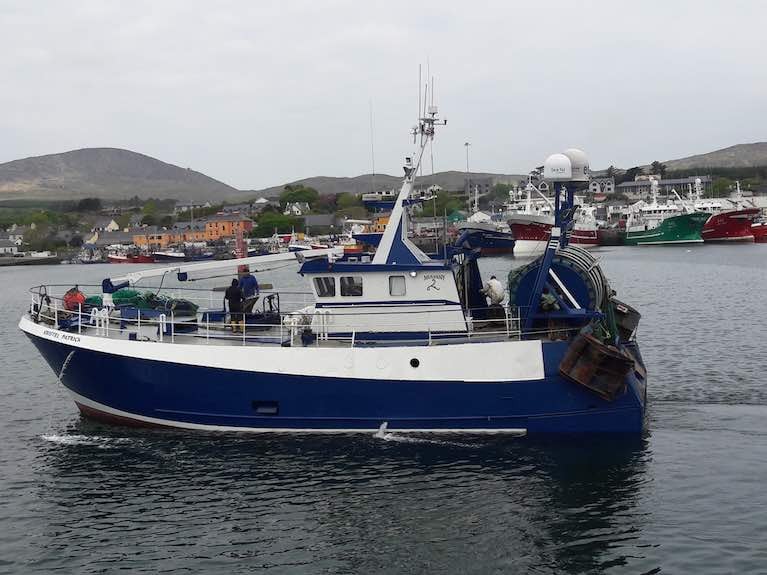
Mayo prawn skipper Paddy Mulvany, who fishes with his 20m Kristel Patrick for 40 per cent of the year in the Celtic Sea, was critical of the department’s “arbitrary” selection which did not include his vessel
He has also questioned the department’s use of the term ” priority vessel” in its response to him last week.
“What does that make the rest of us – second class?” Mulvany said.
"Unless this is sorted, anyone who wants to sell on a boat won't be able to realise its value if it does not have access to British waters," he explained.
Ireland stands to be the biggest loser in a Brexit deal which sees EU member states lose 25 per cent of catch overall, but separate administrative authorisation for continued access “should not have been left to the last minute”, Mr Murphy said.
Killybegs Fishermen’s Organisation (KFO) chief executive Sean O’Donoghue said that the department’s approach was “pragmatic”, in ensuring those vessels preparing to go to sea on January 1st had authorisation.
Mr O’Donoghue said the initial permits only last for three weeks, and expects a second list will be issue for the full year. He said he understood Britain “couldn’t handle” the full list.
Meanwhile, Mr McConalogue and Minister for Foreign Affairs Simon Coveney have said there remains an “increased risk of enforcement action being taken by Scottish fisheries control authorities against Irish vessels operating in the waters around Rockall at present”.
This follows last week’s warning by Marine Scotland to a Donegal vessel fishing within 12 nautical miles of Rockall.
Sinn Féín marine spokesman Padraig MacLochlainn said he had warned the then marine minister Michael Creed in 2019, when the issue last flared up, that a 2013 agreement between the Irish and British governments “essentially recognised British sovereignty over Rockall”.
The 2013 agreement signed by former Tánaiste Eamon Gilmore established a single maritime boundary between the Exclusive Economic Zones (EEZs) of the two countries and parts of their Continental Shelves.
“This is a shameful agreement that has never been ratified by the Dáil,” Mr MacLochlainn said.
Ireland “could have supported the governments of Iceland and Denmark in demanding shared sovereignty and fishing rights around Rockall but chose not to do so”, Mr MacLochlainn said.
There remains an increased risk of enforcement action being taken by Scottish fisheries control authorities against Irish fishing vessels operating in the waters around Rockall at present according to a joint statement by the Ministers for Foreign Affairs and Agriculture, Food and the Marine issued this evening.
The Minister for Foreign Affairs and the Minister for Agriculture, Food and the Marine met to discuss recent developments in relation to Rockall.
As Afloat reported previously, the Ministers says they are 'fully aware' of interactions between an Irish fishing vessel, and a Marine Scotland patrol vessel in recent days.
The Irish Government has been in contact with the relevant Scottish and UK authorities.
The statement says that through this engagement, the Irish Government is seeking to address the issues involved, reflecting the longstanding fisheries tradition in the area. Taking account of the new EU-UK Trade and Cooperation Agreement, this may also require contact with the European Commission.
In addressing these issues, the Minister for Foreign Affairs and the Minister for Agriculture, Food and the Marine, as well as their respective officials, are considering all options for further engagement on the issues involved and are continuing to work closely together.
While engagement continues, the government says there remains an increased risk of enforcement action being taken by Scottish fisheries control authorities against Irish vessels operating in the waters around Rockall at present.
Sinn Fein Criticises Government Handling of Rockall Agreement
Sinn Féin has criticised the Government’s handling of a seven-year-old agreement with Britain on Rockall after an Irish fishing vessel was inspected by a Scottish patrol earlier this week.
Sinn Féin fisheries and marine spokesman Pádraig MacLochlainn was reacting to a claim by the Donegal-based Northern Celt that it was told by Scottish authorities on Monday that it could not fish within 12 miles of Rockall.
Skipper Adrian McClenaghan said he had a permit to continue to fish within British waters.
Mr MacLochlainn said he had warned the then Irish marine minister Michael Creed in 2019 that a 2013 agreement between the Irish and British governments establishing a Single Maritime Boundary between the Exclusive Economic Zones (EEZs) of the two countries and parts of their Continental Shelves, “essentially recognised British sovereignty over Rockall”.
 Padraig MacLochlainn, Sinn Fein spokesman on the Marine
“This is a shameful agreement that has never been ratified by the Dáil,” Mr MacLochlainn said.
Ireland “could have supported the governments of Iceland and Denmark in demanding shared sovereignty and fishing rights around Rockall but chose not to do so”, he said.
He said that Minister for Foreign Affairs Simon Coveney and his Fine Gael party had “created this mess” and “need to sort it out”.
The 2013 agreement was signed on Ireland’s behalf by then Tánaiste and foreign affairs minister Eamon Gilmore.
The Irish government maintains that Rockall, as an uninhabited rock, does not have an EEZ under Article 121 of the UN Convention on the Law of the Sea.
However, when the issue flared up last in mid-2019, two Irish maritime lawyers disagreed.
Rockall expert Prof Clive Symmons of Trinity College, Dublin and Prof Ronán Long, who is ocean governance and law of the sea chair at the World Maritime University, both stated that rocks can generate 12-mile territorial sea limits under the same UN convention.
The Department of Foreign Affairs has said it is aware of “contact between an Irish fishing vessel and a Marine Scotland patrol vessel” and has been in contact with the Scottish and UK authorities.
A Scottish government spokesperson said: “One Irish vessel was routinely inspected outside of territorial waters around Rockall”
"The master requested clarification on the access rights granted by his licence to fish in UK waters,” it said.
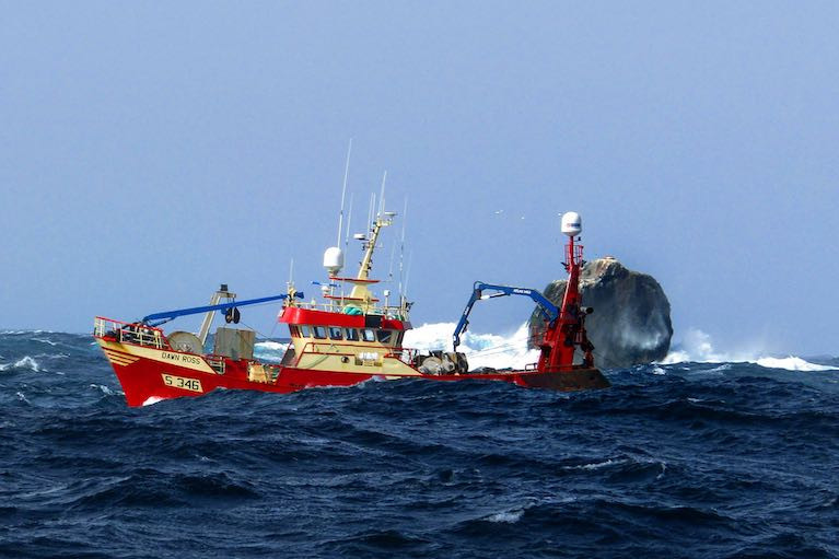
The KFO fears the renewal of tensions over Rockall may jeopardise the seasonal non-quota squid fishery for Irish vessels.
Up to 30 per cent of whitefish, including haddock, caught by Killybegs and Greencastle vessels is taken around Rockall.
Scottish Patrol Boat Prevents Donegal Trawler Fishing at Rockall

The Department of Foreign Affairs has confirmed it is in contact with UK officials after a Donegal trawler was prevented from fishing around Rockall.
RTÉ News reports on the incident yesterday (Monday 4 January) in which the Greencastle-based Northern Celt was boarded by crew from the Scottish fisheries patrol vessel Jura.
The trawler’s skipper Adrian McClenaghan said he was informed “that we could no longer fish inside the 12-mile limit of Rockall” since the end of the Brexit transition period last Thursday 31 December.
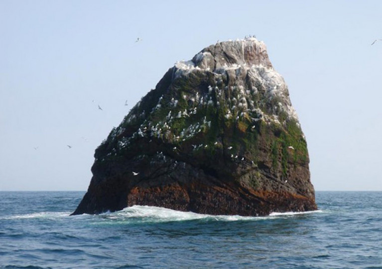
The outcrop in the North Atlantic has been disputed territory for decades. While the UK claims sovereignty, Ireland does not recognise this claim.
As previously reported on Afloat.ie, two Irish experts in maritime law have said Scotland is within its legal rights to assert a 12-mile territorial limit around Rockall as it warned it would do last year.
RTÉ News has more on the story HERE.
Rockall - Legal Experts Says Scotland Right & Ireland Wrong
Two Irish international maritime law experts have said that Scotland is within its legal rights to place a 12-mile territorial limit around Rockall writes Lorna Siggins.
Statements made by Government ministers over the past week have been “incorrect”, as Rockall is entitled to a 12-mile territorial sea, Prof Clive Symmons, Trinity College Dublin maritime law expert says.
Ireland also agreed to Rockall being included in Britain’s exclusive economic zone (EEZ) in March, 2013.
Scotland is “within its rights” to threaten enforcement, and Ireland “hasn’t a leg to stand on” within Rockall’s 12-mile limit, Prof Symmons says.
"Scotland is “within its rights” to threaten enforcement, and Ireland “hasn’t a leg to stand on” within Rockall’s 12-mile limit, Prof Symmons says"
Prof Ronán Long, who is ocean governance and law of the sea chair at the World Maritime University, concurs with Prof Symmons, and says that rocks can generate 12-mile territorial sea limits under UN Law of the Sea convention rules.
Since Scotland warned that it would enforce a 12-mile limit around Rockall from June 7th, Minister for Foreign Affairs Simon Coveney and Minister for Fisheries Michael Creed have challenged its right to do so.
Both ministers have pointed to Article 121 of the UN Convention on the Law of the Sea (UNCLOS) which states that “rocks which cannot sustain human habitation or economic life of their own shall have no EEZ or continental shelf”.
However, such rocks can still “generate territorial limits”, Prof Long and Prof Symmons say - confirming the case made last weekend by Scottish Cabinet Secretary for Rural Economy Fergus Ewing.
Prof Symmons points out that Irish and other EU vessels have been inspected by British authorities off Rockall before and there have been previous detentions.
Recorded detentions include Irish-registered vessels in 1987 and 1994, and a Cypriot-registered vessel with an Icelandic skipper, also in 1994.
Scottish Fisheries Protection Agency vessels have patrolled, inspected and boarded vessels in recent years, as Scotland is “administratively responsible” for Rockall.
Marine Scotland said it could not give figures for number of inspections of Irish vessels for “operational reasons”.
Prof Symmons, who is author of Ireland and the Law of the Sea published in 2000, says Irish governments have spent half a century “acquiescing” to various British claims to the rock, even if Ireland did not accept sovereignty.
“Sovereignty and a maritime zone are two separate issues here, and Ireland did not protest when a 12-mile limit was first placed around the rock in 1964,” Prof Symmons says.
The EU Common Fisheries Policy applies outside 12 mile territorial limits, but vessels from certain other EU states with “traditional rights” may be given access between six and 12 miles under the London Fisheries Convention.
However, Britain plans to leave the London Fisheries Convention next month, and Rockall was never specified in it anyway, Prof Symmons says.
Once Brexit takes effect, Irish and EU vessels will no longer have any rights to fish in British waters, Prof Long points out.
Fishing industry representatives have called on the Government to provide more transparency on the 2013 agreement between Ireland and Britain.
The 2013 agreement bears the names of Tánaiste Eamon Gilmore and then British ambassador to Ireland Dominick Chilcott and delineated the latitudes and longitudes of a “median line” between the EEZs, after boundaries were first agreed in 1988.
The 2013 British/Irish agreement on separate EEZs still has legal standing when applied bilaterally, Prof Symmons says.
Irish South and East Fish Producers’ Organisation chief executive Hugo Boyle confirmed that he raised the issue with Minister for Fisheries Michael Creed last Friday, when industry representatives were called into an emergency meeting and briefed on Scotland’s ultimatum.
The issue of seabed rights claimed by four countries – Ireland, Britain, Denmark (on behalf of the Faroe islands) and Iceland – is still with the UN, and is awaiting Iceland’s submission before it can be agreed.
However, Denmark has no objection to a British 12-mile limit around Rockall, Prof Symmons says.
The Department of Foreign Affairs did not respond to a series of questions on the issue.
Authorities in Ireland have rejected Scotland’s threat of “enforcement action” against Irish trawlers in the waters around Rockall, as the two states fall into a spat over fishing rights in the North Atlantic territory.
The Irish Times reports on a formal letter received yesterday from Scottish external affairs minister Fiona Hyslop, declaring Scotland’s intention to defend its interests against “illegal activity” within 12 miles of the uninhabitable islet.
Rockall, which lies 300km west of Scotland and some 430km north-west of Ireland, is claimed by the United Kingdom — but Ireland does not recognise UK sovereignty over the territory.
In their response, Marine Minister Michael Creed and Tánaiste and Foreign Affairs Minister maintained the position of the Irish Government that “the waters around Rockall form part of Union waters under the Common Fisheries Policy, to which the principle of equal access for the vessels of all EU Member States applies”.
Their statement added: “Irish vessels have operated unhindered in the Rockall zone for many decades fishing haddock, squid and other species.”
The ministers noted that the issue of access to Rockall’s fishing grounds first arouse in 2017 following the Brexit referendum.
“The Tánaiste and I have worked very closely to avoid a situation whereby Irish fishing vessels who have been and continue to fish for haddock, squid and other species in the 12-mile area around Rockall, are under the unwarranted threat of ‘enforcement action’ by the Scottish government,” Minister Creed said yesterday (Friday 7 June).
“However, following this sustained unilateral action by them, I have no option but to put our fishing industry on notice of the stated intention of the Scottish government.”
The Tánaiste said: “The longstanding position of the Irish Government is that Irish vessels are entitled to access to Rockall waters. We have never recognised UK sovereignty over Rockall and accordingly we have not recognised a territorial sea around it either.
“We have tried to work positively with the Scottish authorities and to deal with sensitive issues that flow from it in a spirit of kinship and collaboration. We very much regret that matters have reached this point and intend to do everything possible to achieve a satisfactory resolution.”
Minister Creed has met the fishing industry representatives to explain the situation and to advise them of the threat of enforcement action by the Scottish authorities.
“I am very disappointed to have had to make them aware of the risk,” he said, adding that they are “justifiably concerned at this action being taken by a fellow member states where our industries are closely connected”.
Rockall Record Gets Frank Kowalski Afloat.ie 'Sailor of the Month' Special Award for July
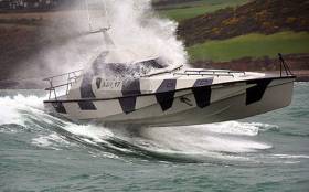
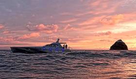
The very special powerboats of SafeHaven Marine in East Cork have multiple uses, but high speed potential in a wide variety of sea conditions is invariably top of a list of very demanding priorities among the highly-regarded company’s prestigious customers.
So when the notion of a Round Ireland and Rockall Powerboat Record first surfaced, inevitably it came from the fertile and visionary mind of SafeHaven’s Frank Kowalksi. And in July, his latest Youghal-built creation Thunder Child took on the 2000-plus kilometres challenge, going anti-clockwise and using refuelling stops at Portrush in County Antrim on the outward passage from the start/finish point of the Old Head of Kinsale, and Ballyglass on Broadhaven in Mayo on the return.
While conditions were favourable, in July’s unsettled weather there were bound to be some distinctly bumpy stages on such a long and exposed course, while many sections near land were notably tide-riven. Yet despite this, Thunder Child came back in round the Old Head of Kinsale on the evening of July 5th just 34 hours one minute and 47 seconds after departing, an average of 32 knots.
The crew of the 17m (53ft 6ins) Thunder Child who supported Frank Kowalski in this Sailor of the Month July Special Award were Ian Brownlee, Ciaran Monks, Mary Power, Peter Gurgul and Carl Randalls.
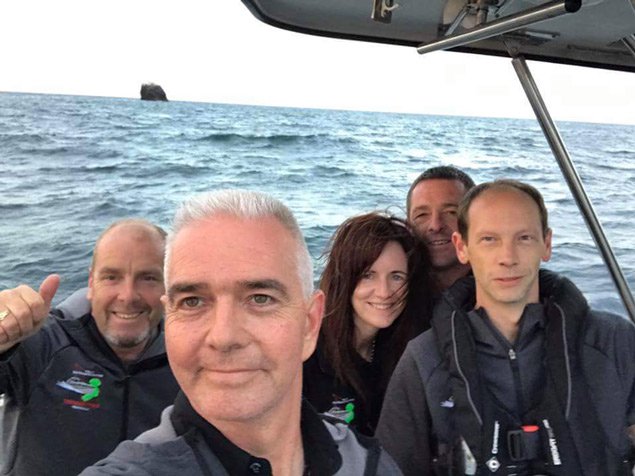 The ultimate selfie – Frank Kowalski (foreground) and the crew of Thunder Child at the small but very important ocean pinnacle of Rockall. Photo: Frank Kowalski
Home Well Before Dark for Thunderchild
Apart from two essential stops at Portrush in County Antrim and Ballyglass on Broadhaven in County Mayo to take on fuel, Safehaven Marine’s challenge for a viable record for the 2000 kilometres round Ireland and Rockall, powering on with their remarkable new speed machine Thunderchild, has seen only two other stops writes W M Nixon.
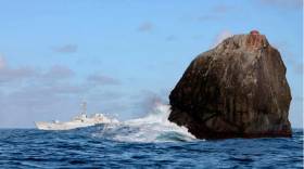
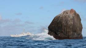
One was to get a photo of the boat at Rockall itself last night, when enough daylight was available at the edge of the short northern darkness to produce a memorable and otherworldly image. And the other, specially important to a crew so closely involved with sea safety, was a pause at Black Rock off the Mayo coast this afternoon to pay their respects to the memory of the crew of air-sea rescue helicopter R 116, tragically lost on a March night four months ago in conditions very different from the summer weather which has now settled over Ireland.
But as this calm weather has followed on an unsettled period, the seas have taken time to smooth down. It’s seldom enough that Thunderchild has been able to enjoy a top speed of 52 knots in a voyage which at one stage saw her slowed back – albeit very briefly - to 20 knots. At 1845 hours this evening (Wednesday) she is at 42 knots coming in past the Fastnet, well on track to set a good time when she completes the circuit at the Old Head of Kinsale with an average speed of better than 33 knots, and neatly on time for a proper welcome home to Cobh well before dark.
It has to be the ulltimate selfie – Frank Kowalski of Safehaven and his crewmates on Thunderchild with Rockall looking very small for a place which could be of great maritime economic significance.


, and Dermot O’Kane, Head of Sales, Esri Ireland. Esri Ireland is announcing that its digital mapping system is helping DURL to prevent 13 million litres of polluted wastewater from entering Dublin rivers annually, by locating misconnected household appliances that are expelling polluted water")


 Michael Murphy Schull Harbour Sailing Club (SHSC), Eric Coogan Heineken Ireland, Mark Murphy, Commodore SHSC, Jack Allen SHSC, Carmel O'Regan SHSC, Cornelious Ndlovu, Schull Harbour Hotel Operations Manager and Derval Murphy SHSC")


