Menu

Ireland's sailing, boating & maritime magazine

Inland afloat headers


Displaying items by tag: Sea Stack

#SeaStack - A famous sea stack off the Co Mayo coast has been climbed for the first time in more than 25 years, as Independent.ie Travel reports.

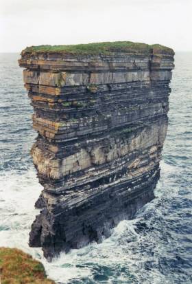
At the end of August, Iain Miller and his climbing partner Paulina Kaniszewska reached the top of Dún Briste, off Downpatrick Head, in what was the third attempt by the former to summit the 50m rock.


One of the more breathtaking spots along the Wild Atlantic Way, it's also considered a particularly dangerous climb that should only be attempted by experts.

But for Miller, the rewards for scaling the summit of a place that has seen fewer visitors on record than men on the moon were more than he could put into words.

Independent.ie Travel has more on the story HERE.

Published in Coastal Notes
16th October 2015

The Sea Stacks of Donegal

The county of Donegal at the North West tip of Ireland boasts two major Irish mountain ranges, over thousand kilometres of coastline, one hundred sea stacks and many diverse climbing locations writes Ian Miller. Donegal currently plays host to many lifetimes worth of world class rock climbing in some of the most beautiful and unspoilt Locations in Ireland. The scope for further exploration and the opportunity to discover unclimbed rock is almost unlimited, as there is an unexplored adventure waiting through every mountain pass and around every remote headland. There is a wealth different types of climbing venues found throughout Donegal from easy accessible road side venues though to huge mountain cliffs found high in the remote Donegal mountains.
What the coast line of Donegal provides for an adventurous rock climber is more rock climbing venues, routes and unclimbed rock than the rest of Ireland combined. The wealth and diversity of the climbing available along this coast line is almost unlimited from the mud stone roof at Muckross in the south of the county to the Granite slabs at Malin head, (Irelands most northerly point) in the North of the county. County Donegal boasts Irelands longest rock climb, the 750 meter long Sturrall Ridge, Irelands highest sea stack, the 150m Tormore Island and Irelands highest mountain crag in the Poison Glen. There are currently over 2800 recorded rock climbs on over 150 cliff faces scattered throughout the county. 
Where the rock climbing on Donegal’s coast line truly excels itself is in its sea stacks. There are a shade under 100 sea stacks with currently just over 150 recorded routes to their summits. The sea stacks are found along the coast of Donegal’s mainland and its western islands sit in some of the most remote, isolated and hostile coastal locations in Ireland. What these sea stacks provide is a large collection of the most adventurous, remote and atmospheric rock climbs in Ireland. 
Sea stack climbing involves accessing huge towers of rock that stick out of the sea, it is this access that makes these locations so special. A day out on a sea stack will typically require a 250 meter descent to sea level to access an isolated storm beach, where it is highly unlikely anyone has ever stood before. This is followed by an UBER committing sea passage along the bases of currently unclimbed 250 meter high sea cliffs in a totally committed and potentially unescapable locations, this will allow you to gain the bases of the sea stacks. The commitment required and the sense of primal fear that accompanies these marine journeys has to experienced to be understood.
. As always, tad of logistics and planning is the key to success and of course the adoption of perhaps less orthodox climbing equipment such as 600m of 6mm polypro, a lightweight Lidl Dingy, a single lightweight paddle, divers booties, a 20ft Cordette, a pair of Speedo’s, heavy duty dry bags, 20m of 12mm polyprop, an alpine hammer, a snow bar, a selection of pegs, a chest harness/inverted Gri-Gri combo and a big Grin! We then climb these towers of rock to arrive on pristine pinpoint summits far from anywhere in the real world. Standing on a pinpoint summit over 100m above the ocean, 500m from the nearest point of land and 20KM from the nearest main road can easily be described as a truly spiritual experience.

Donegal Sea Stacks

Since 2007 I have been exploring the sea stacks of County Donegal, and have currently climbed over 60 previously unclimbed sea stacks along the coast of the county and recorded over 150 new routes on Donegal's Sea Stacks. During these adventures we have seen and experienced firsthand the true beauty of these little known places in coastal Ireland.
donegal sea stacks map

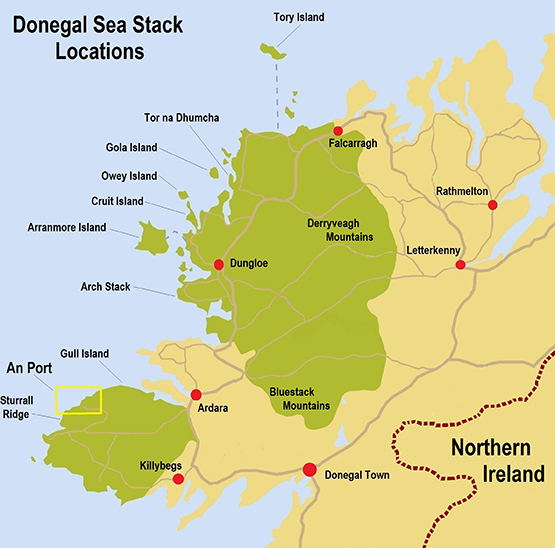
The main residence of the sea stacks is the Slievetooey coastline in the South West of the county, access to this coastline is by a narrow winding 20 km B road which takes you to the An Port road end.


An Staca sea stack

An Port is quite simply the most beautiful location in Ireland a trip to this road end is an outstanding journey in its own right, but it’s what lives either side of this road end that makes it a mind blowing location.
donegal sea stacks
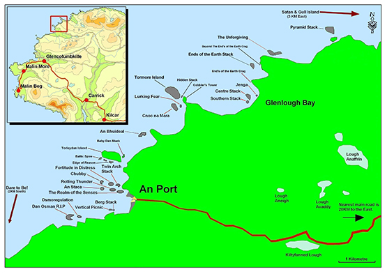
To the south of An Port lives a chain four sea stacks each with an increase in commitment and concern to reach their bases as they span further and further away from the remote storm beach launch pad facing Berg Stack. (link 4) To the South of these stacks the skyline is dominated by the Sturrall Headland, which provides an 750 meter rock climb which requires a 300 meter sea passage to reach its most sea ward tip. The rock climbing grade of this headland is given the little used XS grade as it means there is much more than rock climbing skills required for a safe ascent. Approx a third of the way up the ridge there is a 50 meter long section of climbing that will live forever in your memory! 

An Port South

Travelling North from An Port the sea cliffs and sea stacks just get bigger and bigger. After about a 600 meter cliff top walk you will be overlooking the 90 meter high Toralaydan island. (Link 6) Living on its south and North sides are a further very difficult to access sea stacks. At the sea ward tip of its south side lives the Baltic Tower a route up its sea ward face provides a very scary climb called Icon, and at a very amenable climbing grade it provides a climb on immaculate rock in a terrifying nautical location.
donegal sea stacks 3
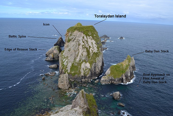
A further 500m to the North of Toralaydan Island lives An Bhuideal (The Bottle, as its north summit looks like a milk bottle when seen from the sea) an immaculate and iconic twin headed stack. There are currently three routes to its twin summits and all three are world class adventurous rock climbs. The super skinny North tower of this stack provides an unforgettable experience of three pitch climbing to its tiny and extremely exposed summit. The abseil descent from this micro summit involves a wee bit of prayer as the summit abseil anchors are a cairn of rocks and the landward face overhang alarmingly in its upper half. It is a very scary place to be! ☺
donegal sea stacks 4

donegal sea stacks 5 
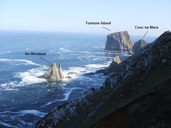
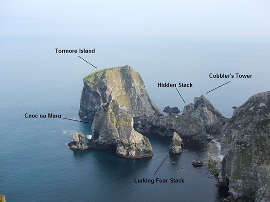
Travelling a further kilometre North along the coast from An Bhuideal takes you to a stunning cliff top viewpoint over looking Tormore Island, Irelands highest sea stack. Living in the shadow of Tormore Island is the 100 meter high Cnoc na Mara, it is difficult not to get emotional when talking about the mighty Cnoc na Mara.

Cnoc na mara Solo

Cnoc na Mara

When I first saw this 100m sea stack from the overlooking cliff tops it was the inspiration to climb every unclimbed sea stack in Donegal. It is safe to say this stack represents all that is great about adventure climbing. It's impressive soaring 150 meter long landward arete provides one of the most rewarding and adventurous rock climbs in Ireland. It is easily an equal to the mighty Old Man of Hoy off the Orkney Islands in the north of Scotland. Access is by a monsterous steep grassy descent followed by a 20 meter abseil to a storm beach at the entrance to Shambhala. As you descent this steep slope, sitting out to sea Cnoc na Mara grows with height as you descend reaching epic proportions as you get closer to the beach. Gaining the beach alone is an adventurous undertaking in its own right and is an excellent taster off what is to come. From the beach you paddle out for about 120 meter to the reach the base of the stack. The Landward arête of the stack is climbed in four pitches each pitch being much more atmospheric than the previous. The fourth pitch being the money shot as it is a 58 meter ridge traverse with 100 meters of air either side of you as you negotiate the short steep sections along this outstanding ridge traverse. 
Gaining the summit is like being reborn into a world where anything is possible, it truly is a surreal and magical place to be. The whole world falls away below and around you, as you are perched on a summit far from anything else in the real world.

Paddle around Tormore Island

Tormore Island is a gigantic leviathan, a sentinel of the deep standing guard at the nautical gates of the Slievetooey coastline. At 150 meters above sea level at its highest point above the ocean it is Ireland's highest sea stack. This huge square topped sea stack can be seen for many kilometres along the coast either side of it. It can even be clearly seen from the Dungloe/Kincaslough road some 40 Kilometres to the north. Access is a very involved and emotional affair and entails gaining the storm beach as for Cnoc na Mara, Lurking Fear and Tormore Island. From here it is a 500 meter long sea passage around the headland to the north of the storm beach and a further 250 meter paddle through the outstanding channel separating Tormore Island and Cobblers Tower on the Donegal mainland. At the northern end of the land ward face of Tormore Island there is a huge non tidal ledge just above the high water mark.
In 2008 a team of four climbers travelled by 250 horse power RiB and landed on the land ward face of the stack. Two members of the party had made several previous attempts to land on and climb the stack in the past. We were aware of the story of the man who was buried here. During our climb of the stack we searched any possible place where someone could be buried and found no possible burial site or any trace of the passage of people on the stack prior to our ascent. We found no evidence or trace of previous visitors on the summit. To get off the summit back to sea level we made four 50 meter abseils leaving behind two 240 cm slings and 5 pitons as abseil anchors.
We climbed the very obvious land ward arete at the northern end of the land ward face of the sea stack, This huge feature can be easily seen from any position along the coast overlooking the stack. The route we took to the summit was climbed in 5 long pitches following the easiest climbing we could find up this huge feature.

donegal sea stacks 6
To the North of the Tormore Island view point, the coastline falls away into Glenlough bay, a truly spectacular bay containing a further 4 sea stacks and Irelands largest raised shingle storm beach. On a day of huge north west sea motion the roar of a billions of tonnes of shingle being moved up and down the beach by the incoming seas can be deafening even from the cliff tops 200 meters above the beach.
To the north of Glenlough bay the land swings 90 degrees to face north and for a distance of 7 kilometres the sea cliffs increase to 300 meters high. At the base of these monster sea cliffs are a further four extremely inaccessible sea stacks, the 60 meters high Unforgiven Stack, the 50 meter high Pyramid Stack, the 80 meter high Satan and the 90 meter high Gull Island. Of these sea stacks Satan is the daddy, This sea stack is one of the most fearsome and dangerous stacks in Ireland. It sits off the north west face of the mighty Gull Island and presents considerable logistical and nautical access problems requiring a tad of nautical planning prior to attempting an ascent. 


The most remote place in Ireland?

Access is by walking 4KM over the Slievetooey summit from the south and descending it's northern slopes to an outstanding location on the clifftops over looking Gull Island. Descend the very steep grass to the boulder beach joining Gull Island to the mainland. There is an abseil stake in place (2009) to safeguard the initial part of the descent. Once on the boulder beach paddle 500 or so meters west along the base of Gull Island to the entrance of a surreal gothic channel separating Satan and Gull Island. This channel is outrageous and leads you to the only landing place on the stack. Land on the stack at the convergance of the channels in the centre of this gothic labyrinth.
The stack was climbed in three pitches up it's south face culminating in a superb final pitch up a steep groove and rocky ridge traverse onto the majestic and super scary summit. The stack is so named as, if you make a mess of it the beast will take your soul. 


Solo First Ascent


The Icon


Owey Island


Centre Stack

For more information click here to down load Iain Millers' free guidebook 

Published in Coastal Notes
Tagged under

General Information on using Waterways Ireland inland navigations

Safety on the Water

All users of the navigations are strongly recommended to make themselves aware of safety on the water for whatever activity they are involved in and to read the advice offered by the various governing bodies and by:

The Dept. of Transport, Ireland: www.gov.ie/transport and The Maritime and Coastguard Agency, UK, The RNLI – Water Safety Ireland for information in terms of drowning prevention and water safety.

Registration of Vessels

All vessels using the Shannon Navigation, which includes the Shannon-Erne Waterways and the Erne System must be registered with Waterways Ireland. Only open undecked boats with an engine of 15 horsepower or less on the Shannon Navigation, and vessels of 10 horsepower or less on the Erne System, are exempt. Registration is free of charge.

Craft registration should be completed online at: https://www.waterwaysireland.org/online-services/craft-registration

Permits for use of the Grand and Royal Canals and the Barrow Navigation

All vessels using the Grand and Royal Canals and the Barrow Navigation must display appropriate valid Permit(s) i.e A Combined Mooring and Passage Permit (€126) and if not intending to move every five days, an Extended Mooring Permit (€152).

Permit applications should be completed online at: https://www.waterwaysireland.org/online-services/canal-permits

Passage on the Royal and Grand Canals – Dublin Area

For boat passage through the locks east of Lock 12 into / out of Dublin on either the Royal or Grand Canals, Masters are requested to contact the Waterways Ireland Eastern Regional Office (M-F 9.30am-4.30pm) on tel: +353(0)1 868 0148 or email [email protected] prior to making passage in order to plan the necessary lock-keeping assistance arrangements.

On the Grand Canal a minimum of two days notice prior to the planned passage should be given, masters should note that with the exception of pre-arranged events, a maximum of 2 boats per day will be taken through the locks, travelling either east or west.

Movements in or out of the city will be organised by prior arrangement to take place as a single movement in one day. Boaters will be facilitated to travel the system if their passage is considered to be safe by Waterways Ireland and they have the valid permit(s) for mooring and passage.

Newcomen Lifting Bridge

On the Royal Canal two weeks’ notice of bridge passage (Newcomen Lifting Bridge) is required for the pre-set lift date, and lock assistance will then also be arranged. A minimum of 2 boats is required for a bridge lift to go ahead.

Waterways Ireland Eastern Regional Office (Tel: +353(0)1 868 0148 or [email protected] ) is the point of contact for the bridge lift.

A maximum number of boats passing will be implemented to keep to the times given above for the planned lifts (16 for the Sat / Sun lifts & 8 for the weekday lifts). Priority will be given on a first come first served basis.

On day of lift, boaters and passengers must follow guidance from Waterways Ireland staff about sequence of passage under bridge & through Lock 1, and must remain within signed and designated areas.

Events Held on the Waterways

All organised events taking place on the waterways must have the prior approval of Waterways Ireland. This is a twelve week process and application forms must be accompanied with the appropriate insurance, signed indemnity and risk assessment. The application should be completed on the Waterways Ireland events page at :

https://www.waterwaysireland.org/online-services/event-approval

Time Limits on Mooring in Public Harbours

On the Shannon Navigation and the Shannon-Erne Waterway craft may berth in public harbours for five consecutive days or a total of seven days in any one month.

On the Erne System, revised Bye Laws state that: No master or owner shall permit a vessel, boat or any floating or sunken object to remain moored at or in the vicinity of any public mooring, including mooring at any other public mooring within 3 kilometres of that location, for more than 3 consecutive days and shall not moor at that same mooring or any other public mooring within 3 kilometres of that location within the following 3 consecutive days without prior permission by an authorised official.

Winter Mooring on the Shannon Navigation and Shannon Erne Waterway

Winter mooring may be availed of by owners during the period 1 Nov to 31 Mar by prior arrangement and payment of a charge of €63.50 per craft. Craft not availing of Winter Mooring must continue to comply with the “5 Day Rule”. Winter Mooring applications should be completed online at : https://www.waterwaysireland.org/online-services/winter-moorings-booking

Owners should be aware that electricity supply and water supply to public moorings is disconnected for the winter months. This is to protect against frost damage, to reduce running costs and to minimise maintenance requirements during the winter months.

Vessel owners are advised that advance purchasing of electricity on the power bollards leading up to the disconnection date should be minimal. Electricity credit existing on the bollards will not be recoverable after the winter decommissioning date. Both services will be reinstated prior to the commencement of the next boating season.

Smart Cards

Waterways Ireland smart cards are used to operate locks on the Shannon Erne Waterway, to access the service blocks, to use the pump-outs along the navigations, to avail of electrical power at Waterways Ireland jetties.

Berthing in Public Harbours

Masters are reminded of the following:

  • Equip their vessel with mooring lines of appropriate length and strength and only secure their craft to mooring bollards and cleats provided for this purpose.
  • Ensure the available berth is suitable to the length of your vessel, do not overhang the mooring especially on finger moorings on floating pontoon moorings.
  • Ensure mooring lines, electric cables and fresh water hoses do not create a trip hazard on public jetties for others users.
  • Carry sufficient fenders to prevent damage to your own vessel, other vessels and WI property.
  • Allow sufficient space between your vessel and the vessel ahead /astern (c.1m) for fire safety purposes and /or to recover somebody from the water.
  • Do not berth more than two vessels side by side and ensure there is safe access/egress at all times between vessels and onto the harbour itself.
  • Do not berth in such a way to prevent use of harbour safety ladders, slipways or pump-outs.
  • Do not allow the bow of your vessel to overhang the walkway of a floating mooring thus creating a hazard for others with an overhanging anchor or bow fendering.
  • Animals are not allowed to be loose or stray at any time.
  • Harbour and jetty infrastructure such as railings, power pedestals, fresh water taps, electric light poles, safety bollards, ladders etc are not designed for the purpose of mooring craft , they will not bear the strain of a vessel and will be damaged.
  • At Carrybridge on the Erne System, Masters of vessels are not permitted to use stern on mooring. Masters of vessels must use the mooring fingers for mooring of vessels and for embarkation / disembarkation from vessels.

Passenger Vessel Berths

Masters of vessels should not berth on passenger vessel berths where it is indicated that an arrival is imminent. Passenger vessels plying the navigations generally only occupy the berths to embark and disembark passengers and rarely remain on the berths for extended periods or overnight.

Lock Lead-in Jetties

Lead-in jetties adjacent to the upstream and downstream gates at lock chambers are solely for the purpose of craft waiting to use the lock and should not be used for long term berthing.

Vessel Wake

Vessel wake, that is, the wave generated by the passage of the boat through the water, can sometimes be large, powerful and destructive depending on the hull shape and engine power of the vessel. This wake can be detrimental to other users of the navigation when it strikes their craft or inundates the shoreline or riverbank. Masters are requested to frequently look behind and check the effect of their wake / wash particularly when passing moored vessels, on entering harbours and approaching jetties and to be aware of people pursuing other activities such as fishing on the riverbank.

Speed Restriction

A vessel or boat shall not be navigated on the Shannon Navigation at a speed in excess of 5 kph when within 200 metres of a bridge, quay, jetty or wharf, when in a harbour or canal or when passing within 100 metres of a moored vessel or boat.

Vessels navigating the Shannon-Erne Waterway should observe the general 5 kph speed limit which applies along the waterway. This is necessary in order to prevent damage to the banks caused by excessive wash from vessels.

Vessels navigating the Erne System should observe the statutory 5kt / 6mph / 10kph speed limit areas.

A craft on the Royal and Grand canals shall not be navigated at a speed in excess of 6km per hour.

A craft on the Barrow Navigation shall not be navigated at a speed in excess of 11km per hour except as necessary for safe navigation in conditions of fast flow.

Bank Erosion

Narrow sections of all the navigations are particularly prone to bank erosion due to the large wash generated by some craft. Masters are requested to be vigilant and to slow down to a speed sufficient to maintain steerage when they observe the wash of their craft inundating the river banks.

Unusual Waterborne Activity

Unusual waterborne vessels may be encountered from time to time, such as, hovercraft or amphibious aircraft / seaplanes. Masters of such craft are reminded to apply the normal “Rule of the Road” when they meet conventional craft on the water and to allow extra room to manoeuvre in the interest of safety.

Sailing Activity

Mariners will encounter large numbers of sailing dinghies from late June to August in the vicinity of Lough Derg, Lough Ree and Lower Lough Erne. Sailing courses are marked by yellow buoys to suit weather conditions on the day. Vessels should proceed at slow speed and with due caution and observe the rules of navigation when passing these fleets, as many of the participants are junior sailors under training.

Rowing

Mariners should expect to meet canoes and vessels under oars on any part of the navigations, but more so in the vicinity of Athlone, Carrick-on-Shannon, Coleraine, Enniskillen and Limerick. Masters are reminded to proceed at slow speed and especially to reduce their wash to a minimum when passing these craft as they can be easily upset and swamped due to their very low freeboard and always be prepared to give way in any given traffic situation.

Canoeing

Canoeing is an adventure sport and participants are strongly recommended to seek the advice of the sport’s governing bodies i.e Canoeing Ireland and the Canoe Association of Northern Ireland, before venturing onto the navigations.

Persons in charge of canoes are reminded of the inherent danger to these craft associated with operating close to weirs, sluice gates, locks and other infrastructure particularly when rivers are in flood and large volumes of water are moving through the navigations due to general flood conditions or very heavy localised precipitation e.g. turbulent and broken water, stopper waves. Shooting weirs is prohibited without prior permission of Waterways Ireland.

Canoeists should check with lockkeepers prior entering a lock to ensure passage is done in a safe manner. Portage is required at all unmanned locks.

Canoe Trail Network – "Blueways"

Masters of powered craft are reminded that a canoe trail network is being developed across all navigations and to expect more organised canoeing along these trails necessitating slow speed and minimum wash when encountering canoeists, rowing boats etc

Rockingham and Drummans Island Canals – Lough Key

It is expected that work on Rockingham and Drummans Island Canals on Lough Key will be completed in 2021. Access to these canals will be for non-powered craft only, eg canoes, kayaks, rowing boats.

Fast Powerboats and Personal Watercraft (Jet Skis)

Masters of Fast Powerboats (speed greater than 17kts) and Personal Watercraft (i.e.Jet Skis) are reminded of the inherent dangers associated with high speed on the water and especially in the confines of small bays and narrow sections of the navigations. Keeping a proper look-out, making early alterations to course and /or reducing speed will avoid conflict with slower vessels using the navigation. Personal Watercraft are not permitted to be used on the canals.

Towing Waterskiers, Wakeboarders, Doughnuts etc

Masters of vessels engaged in any of these activities are reminded of the manoeuvring constraints imposed upon their vessel by the tow and of the added responsibilities that they have to the person(s) being towed. These activities should be conducted in areas which are clear of conflicting traffic. It is highly recommended that a person additional to the master be carried to act as a “look-out” to keep the tow under observation at all times.

Prohibition on Swimming

Swimming in the navigable channel, particularly at bridges, is dangerous and is prohibited due to the risk of being run over by a vessel underway in the navigation.

Age Restrictions on operating of powered craft

In the Republic of Ireland, Statutory Instrument 921 of 2005 provides the legal requirements regarding the minimum age for operating of powered craft. The Statutory Instrument contains the following requirements:

- The master or owner of a personal watercraft or a fast power craft shall take all reasonable steps to ensure that a person who has not attained the age of 16 years does not operate or control the craft

- The master or owner of a pleasure craft powered by an engine with a rating of more than 5 horse power or 3.7 kilowatts shall take all reasonable steps to ensure that a person who has not attained the age of 12 years does not operate or control the craft.

Lifejackets and Personal Flotation Devices (PFDs)

Lifejackets and PFD’s are the single most important items of personal protective equipment to be used on a vessel and should be worn especially when the vessel is being manoeuvred such as entering / departing a lock, anchoring, coming alongside or departing a jetty or quayside.

In the Republic of Ireland, Statutory Instrument 921 of 2005 provides the legal requirements regarding the wearing of Personal Flotation Devices. The Statutory Instrument contains the following requirements:

- The master or owner of a pleasure craft (other than a personal watercraft) shall ensure, that there are, at all times on board the craft, sufficient suitable personal flotation devices for each person on board.

- A person on a pleasure craft (other than a personal watercraft) of less than 7 metres length overall shall wear a suitable personal flotation device while on board an open craft or while on the deck of decked craft, other than when the craft is made fast to the shore or at anchor.

- The master or owner of a pleasure craft (other than a personal watercraft) shall take all reasonable steps to ensure that a person who has not attained the age of 16 years complies with paragraph above.

- The master or owner of a pleasure craft (other than a personal watercraft), shall take all reasonable steps to ensure that a person who has not attained the age of 16 years wears a suitable personal flotation device while on board an open craft or while on the deck of a decked craft other than when it is made fast to the shore or at anchor.

- The master or owner of a pleasure craft (other than a personal watercraft) shall take all reasonable steps to ensure that a person wears a suitable personal flotation device, at all times while – (a) being towed by the craft, (b) on board a vessel or object of any kind which is being towed by the craft.

Further information is available at: http://www.irishstatutebook.ie/eli/2005/si/921/made/en/print

Firing Range Danger Area – Lough Ree

The attention of mariners is drawn to the Irish Defence Forces Firing Range situated in the vicinity of buoys No’s 2 and 3, on Lough Ree on the Shannon Navigation. This range is used regularly for live firing exercises, throughout the year, all boats and vessels should stay clear of the area marked with yellow buoys showing a yellow "X" topmark and displaying the word "Danger".

Shannon Navigation, Portumna Swing Bridge Tolls

No attempt should be made by Masters’ of vessels to pay the bridge toll while making way through the bridge opening. Payment will only be taken by the Collector from Masters when they are secured alongside the jetties north and south of the bridge.

Navigating from Killaloe to Limerick on the Shannon Navigation

The navigation from Killaloe to Limerick involves passage through Ardnacrusha locks, the associated headrace and tailrace and the Abbey River into Limerick City. Careful passage planning is required to undertake this voyage. Considerations include: lock passage at Ardnacrusha, water flow in the navigation, airdraft under bridges on Abbey River in Limerick, state of tide in Limerick

Users are advised to contact the ESB Ardnacrusha hydroelectric power station (00353 (0)87 9970131) 48 hours in advance of commencing their journey to book passage through the locks at Ardnacrusha. It is NOT advised to undertake a voyage if more than one turbine is operating (20MW), due to the increased velocity of flow in the navigation channel, which can be dangerous. To ascertain automatically in real time how many turbines are running, users can phone +353 (0)87 6477229.

For safety reasons the ESB has advised that only powered craft with a capacity in excess of 5 knots are allowed to enter Ardnacrusha Headrace and Tailrace Canals.

Passage through Sarsfield Lock should be booked on +353-87-7972998, on the day prior to travel and it should be noted also that transit is not possible two hours either side of low water.

A Hydrographic survey in 2020 of the navigation channel revealed that the approach from Shannon Bridge to Sarsfield Lock and the Dock area has silted up. Masters of vessels and water users are advised to navigate to the Lock from Shannon bridge on a rising tide one or two hours before High Tide.

Lower Bann Navigation

The attention of all users is drawn to the “Users Code for the Lower Bann”, in particular to that section covering “Flow in the River” outlining the dangers for users both on the banks and in the navigation, associated with high flow rates when the river is in spate. Canoeists should consult and carry a copy of the “Lower Bann Canoe Trail” guide issued by the Canoe Association of Northern Ireland. Users should also contact the DfI Rivers Coleraine, who is responsible for regulating the flow rates on the river, for advisory information on the flow rates to be expected on any given day.

DfI Rivers Coleraine. Tel: 0044 28 7034 2357 Email: [email protected]

Lower Bann Navigation – Newferry – No wake zone

A No Wake Zone exists on the Lower Bann Navigation at Newferry. Masters of vessels are requested to proceed at a slow speed and create no wake while passing the jetties and slipways at Newferry.

Overhead Power Lines (OHPL) and Air draft

All Masters must be aware of the dangers associated with overhead power lines, in particular sailing vessels and workboats with cranes or large air drafts. Voyage planning is a necessity in order to identify the location of overhead lines crossing the navigation.

Overhead power line heights on the River Shannon are maintained at 12.6metres (40 feet) from Normal Summer level for that section of navigation, masters of vessels with a large air draft should proceed with caution and make additional allowances when water levels are high.

If a vessel or its equipment comes into contact with an OHPL the operator should NOT attempt to move the vessel or equipment. The conductor may still be alive or re-energise automatically. Maintain a safe distance and prevent third parties from approaching due to risk of arcing. Contact the emergency services for assistance.

Anglers are also reminded that a minimum ground distance of 30 metres should be maintained from overhead power lines when using a rod and line.

Submarine Cables and Pipes

Masters of vessels are reminded not to anchor their vessels in the vicinity of submarine cables or pipes in case they foul their anchor or damage the cables or pipes. Look to the river banks for signage indicating their presence.

Water Levels - Precautions

Low Water Levels:

When water levels fall below normal summer levels masters should be aware of:

Navigation

To reduce the risk of grounding masters should navigate on or near the centreline of the channel, avoid short cutting in dog-legged channels and navigating too close to navigation markers.

Proceeding at a slow speed will also reduce “squat” effect i.e. where the vessel tends to sit lower in the water as a consequence of higher speed.

Slipways

Reduced slipway length available under the water surface and the possibility of launching trailers dropping off the end of the concrete apron.

More slipway surface susceptible to weed growth requiring care while engaged in launching boats, from slipping and sliding on the slope. Note also that launching vehicles may not be able to get sufficient traction on the slipway once the craft is launched to get up the incline.

Bank Erosion

Very dry riverbanks are more susceptible to erosion from vessel wash.

Lock Share

Maximising on the number of vessels in a lock will ensure that the total volume of water moving downstream is decreased. Lock cycles should be used for vessels travelling each way.

High Water Levels:

When water levels rise above normal summer level masters should be aware of:

Navigation

Navigation marks will have reduced height above the water level or may disappear underwater altogether making the navigable channel difficult to discern.

In narrow sections of the navigations water levels will tend to rise more quickly than in main streams and air draft at bridges will likewise be reduced.

There will also be increased flow rates particularly in the vicinity of navigation infrastructure such as bridges, weirs, locks etc where extra care in manoeuvring vessels will be required.

Harbours and Jetties

Due care is required in harbours and at slipways when levels are at or near the same level as the harbour walkways' as the edge will be difficult to discern especially in reduced light conditions. It is advised that Personal Flotation Devices be worn if tending to craft in a harbour in these conditions.

Slipways

Slipways should only be used for the purpose of launching and recovering of water craft or other objects from the water. Before using a slipway it should be examined to ensure that the surface has sufficient traction/grip for the intended purpose such as launching a craft from a trailer using a vehicle, that there is sufficient depth of water on the slipway to float the craft off the trailer before the concrete apron ends and that the wheels of the trailer do not drop off the edge of the slipway. That life-saving appliances are available in the vicinity, that the vehicle is roadworthy and capable of coping with the weight of the trailer and boat on the incline. It is recommended that slipway operations are conducted by two persons.

Caution to be Used in Reliance upon Aids to Navigation

The aids to navigation depicted on the navigation guides comprise a system of fixed and floating aids to navigation. Prudent mariners will not rely solely on any single aid to navigation, particularly a floating aid to navigation. With respect to buoys, the buoy symbol is used to indicate the approximate position of the buoy body and the ground tackle which secures it to the lake or river bed. The approximate position is used because of the practical limitations in positioning and maintaining buoys in precise geographical locations. These limitations include, but are not limited to, prevailing atmospheric and lake/river conditions, the slope of and the material making up the lake/river bed, the fact that the buoys are moored to varying lengths of chain, and the fact that the buoy body and/or ground tackle positions are not under continuous surveillance. Due to the forces of nature, the position of the buoy body can be expected to shift inside and outside the charted symbol.

Buoys and perches are also moved out of position or pulled over by those mariners who use them to moor up to instead of anchoring. To this end, mariners should always monitor their passage by relating buoy/perch positions with the published navigation guide. Furthermore, a vessel attempting to pass close by always risks collision with a yawing buoy or with the obstruction that the buoy or beacon/perch marks.

Masters of Vessels are requested to use the most up to date Navigation guides when navigating on the Inland Waterways.

Information taken from Special Marine Notice No 1 of 2023