Menu

Ireland's sailing, boating & maritime magazine

Inland afloat headers


Displaying items by tag: SeaMonitor

The Loughs Agency welcomed an international delegation of almost 100 marine scientists, academics and political representatives to Derry for the much-anticipated SeaMonitor-STRAITS Conference, which took place at the city’s Guildhall on Thursday 23 and Friday 24 February.

The two-day event, which was compered by biologist and comedian Simon Watt, provided an opportunity for the consortium working on the Loughs Agency-led SeaMonitor project to present their findings and highlight the benefits of tracking aquatic life in our seas and rivers.

It’s hoped that the data collated will be utilised to help inform policy and management decisions, with the protection of vulnerable marine species a priority throughout the process. The species targeted included salmon, seals, basking sharks, cetaceans and skate.

The SeaMonitor project has received €4.7m of funding from the European Union’s INTERREG VA Programme, managed by the Special EU Programmes Body (SEUPB). Match-funding for this project has been provided by the Department for Agriculture, Environment and Rural Affairs in Northern Ireland and the Department of Housing, Planning and Local Government in Ireland.

Ross McGill shows Richard Hill, Joint Secretary of the North South Ministerial Council, the Loughs Agency’s Marine MachineRoss McGill shows Richard Hill, Joint Secretary of the North South Ministerial Council, the Loughs Agency’s Marine Machine

Over 1,000 animals were tagged throughout the life of SeaMonitor, while the receivers picked up over 4.5 million detections of a variety of species.

SeaMonitor also made waves in science circles for its innovation and ambition, with Europe’s largest fish counter deployed in the North Channel between Malin Head and Islay as part of the project. This particular counter measures comes in at over 60km and 100 receivers in length, demonstrating the scale of this important work.

Loughs Agency has collaborated with the European Tracking Network (ETN) throughout this process, with similar counters deployed in the Danish Straits, the Strait of Gibraltar and the Strait of Bosphorus and Dardanelles.

Sharon McMahon, Loughs Agency CEO addresses the conferenceSharon McMahon, Loughs Agency CEO addresses the conference

Day two of the conference focused on STRAITS, a new project that has received EU funding to the tune of €3.5 million as part of the Horizon 2030 initiative.

In collaboration with partners from ETN, this four-year project will run until the end of 2026 and will essentially act as the successor to SeaMonitor, ensuring that the landmark counter in the North Channel is redeployed and integrated with the other major counters around Europe.

A range of dignitaries attended the conference, including the Mayor of Derry City and Strabane District Council, Cllr Sandra Duffy; Gina McIntyre, CEO of the Special EU Programmes Body (SEUPB); and Mark Hanniffy and Richard Hill, Joint Secretaries of the North South Ministerial Council — all of whom conducted speeches expressing their admiration for the collaborative approach taken throughout the duration of the project.

The consortium working on SeaMonitor comprised the Loughs Agency, Atlantic Technological University, University College Cork, the University of California Davis, the Agri-Food and Biosciences Institute, Queen’s University Belfast, Ocean Tracking Network (Dalhousie University), Marine Institute and the University of Glasgow. All members of the working group were in attendance at the Guildhall.

Published in Marine Science
Tagged under

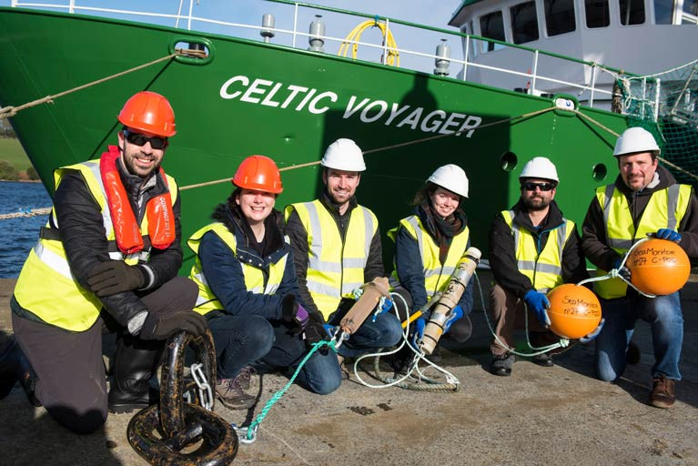
The next SeaMonitor survey will be carried out by the RV Celtic Voyager in the North Channel from tomorrow, Wednesday 29 September.

This latest stage of the project aims to deploy 80 acoustic listening stations (ALSs) across the North Channel from Malin Head in Ireland to the Isle of Islay in Scotland between over four days, concluding on Saturday 2 October.

These stations will allow recording the presence of tagged marine wildlife including salmon, seals, cetaceans, basking shark and skate species, and provide evidence for conservation measures.

The SeaMonitor project is already ahead of schedule, as previously reported on Afloat.ie, with researchers from Nova Scotia in Canada carrying out expert field work using large-scale acoustic telemetry equipment.

This week’s survey operations will be carried out during daylight hours to facilitate a safe deployment of acoustic receivers on the seabed. The RV Celtic Voyager (callsign EIQN) will display appropriate lights and signals throughout.

For details on relevant locations and contact information, see Marine Notice No 54 of 2021 which can be downloaded below.

Published in Marine Science

Field personnel from the Ocean Tracking Network (OTN) based at Dalhousie University in Nova Scotia are currently in the North West working with the team servicing critical animal tracking infrastructure in support of the SeaMonitor project.

Led by the Loughs Agency and supported by eight leading marine research institutions, SeaMonitor is delivering Europe’s largest fish monitoring array using advanced, large-scale technology, as previously reported on Afloat.ie.

The project aims to track the movements of some of the ocean’s most vulnerable species including Atlantic salmon, flapper skate, basking sharks, seals and cetaceans.

Data collected by researchers will be used to help inform marine policy and management frameworks and support conservation measures.

OTN field personnel Cassandra Hartery and Caitlin Bate have been carrying out expert field work coordinated alongside Diego del Villar, senior scientific officer for the SeaMonitor project at the Loughs Agency, using large-scale acoustic telemetry equipment.

“OTN has once again come up trumps for the agency and the SeaMonitor project by lending their expertise to help our team with the retrieval and redeployment of Europe’s largest array,” said Loughs Agency chief executive Sharon McMahon.

“The ocean is a massive, dynamic and challenging environment to work in. Our priority is to get the equipment safely out of the water and I am delighted at the excellent progress to deliver such significant and innovative marine research data that will ultimately help protect some of our most important and vulnerable marine species.

“The agency’s specialist team together with project partners are continuing to work hard to ensure project objectives are delivered whilst following COVID-19 protocols and the amazing work undertaken recently puts us well ahead of schedule.”

Funding for the SeaMonitor project has been provided under the environment objective of the European Union’s INTERREG VA Programme, which is managed by the Special EU Programmes Body (SEUPB), to the tune of €4.7m.

Match-funding for this project has been provided by the Department for Agriculture, Environment and Rural Affairs (DAERA) in Northern Ireland and the Department of Housing, Planning and Local Government in Ireland.

Key support and expertise was also provided by DEARA whose vessel, The Queen of Ulster, was used to take the project scientists out for the retrievals last week. Other vital field work was carried out at Loughs Agency headquarters in Derry and in Lough Foyle.

For more information about the project visit the Lough Agency’s SeaMonitor portal or follow the project on Twitter at @SeaMonitor1.

Published in Marine Science
Tagged under

The ability to track free-swimming salmon juveniles has been extended hundreds of kilometres into the open ocean using advanced robotic technology.

As part of the EU INTERREG VA-funded SeaMonitor project, Dr Ross O'Neill of the Marine Institute and Kieran Adlum, P&O Maritime, tested a remotely operated ocean glider along the steeply sloping area of the shelf edge some 130km north-west of the Scottish Hebrides.

The torpedo-shaped device, equipped with an acoustic tag detector, was deployed from the RV Celtic Explorer on 16 April during the 2021 Irish Anglerfish and Megrim Survey.

This is the first time such active tracking technology has been applied to Atlantic salmon in Europe.

During its two-month mission, the glider successfully detected four individual juvenile salmon smolts measuring only 15-19cm, nearly 600km from their home rivers in Ireland, Northern Ireland and Scotland.

These fish had been tagged between four and six weeks previously with electronic acoustic transmitting tags along with hundreds of other juvenile salmon as part of the SeaMonitor project as well as the West Coast Tracking Project, a partnership between the Atlantic Salmon Trust, Fisheries Management Scotland and Marine Scotland, EU INTERREG VA-funded COMPASS project and Agri-Food Biosciences Institute (AFBI) research initiatives.

One of the main aims of these projects is to investigate the persistent low marine survival of Atlantic salmon in the early stages of their oceanic migration to feeding grounds in the North Atlantic.

The four fish originated from the River Burrishoole in Co Mayo, the River Bann in Northern Ireland and the rivers Clyde and Awe in Scotland.

Up to now, most tracking studies had been limited to estuarine or coastal areas due to technology limitations and the need for stationary receivers.

Map showing SeaMonitor Atlantic salmon smolt detection and release locations

According to Dr Niall Ó Maoiléidigh of the Marine Institute and principal investigator for the SeaMonitor project: “The detection of these fish confirms the importance of the shelf edge in this amazing journey, as the faster currents associated with the steep slopes most likely act as an aquatic transport system facilitating the northward migration of these tiny fish through a very harsh environment.”

Prof Colin Adams of the University of Glasgow and principal investigator for the SeaMonitor Project added: “This study shows that tracking salmon over considerable distances at sea can be achieved which is crucial for research into highly migratory marine species especially where mortality may be occurring far from the shore.”

Dr Ciaran Kelly, director of fisheries ecosystems and advisory services at the Marine Institute, said: “The use of the glider to track the movements of even very small fish has been clearly demonstrated and this will encourage the use of autonomous underwater vehicles to improve information on many marine species of animals which may be endangered or threatened without interfering with their natural migrations.”

The SeaMonitor project is “breaking the boundaries of research into the marine migration journey of the iconic Atlantic salmon”, said Loughs Agency chief executive Sharon McMahon.

“This innovative research will help to identify migratory routes and factors influencing salmon survival at sea, providing data to inform future research and decision making.”

The glider is part of the SeaMonitor integrated cross-jurisdiction major network of acoustic receivers, robotic underwater vehicles, satellite tracking and passive acoustic receivers in European waters and its use will be extended to track cetaceans, basking shark and skates as well as to collect physical oceanographic data.

When combined, the data will enable a holistic view of the regions mobile marine species and will prove invaluable to the regions managers, as well as establishing an integrated network of marine receivers for future applications and extended monitoring.

Match-funding for the project has been provided by Northern Ireland’s Department of Agriculture, Environment & Rural Affairs (DAERA) and the Department of Housing, Local Government and Heritage in Ireland.

For more information about the project visit the Lough Agency’s SeaMonitor portal or follow the project on Twitter at @SeaMonitor1.

Published in Marine Science

Important research that will help advance the management of our seas around Ireland, Western Scotland and Northern Ireland has not totally ceased during the coronavirus pandemic.

The SeaMonitor project, which is led by the Loughs Agency and supported by another eight leading marine science research institutions, was able to deploy some of its innovative species tracking technology to better understand and protect vulnerable marine life in our oceans.

Since April, following work on a tracking array at sea from the RV Celtic Voyager, scientists from across the partnership have managed to safely tag and release over 250 fish from five rivers in Ireland, Northern Ireland and Scotland with trackers.

The technology behind them, called acoustic telemetry, involves deploying a series of listening stations from Malin Head to the island of Islay in Scotland that will record transmissions from a variety of marine species tagged by the project’s scientists.

The data, which is due to be downloaded from the receivers in the autumn, will be used to support the conservation of a variety of vulnerable species such as salmon, basking sharks, skate, dolphins, whales and seals.

Funding for the SeaMonitor project to the tune of €4.7m has been provided under the environment objective of the European Union’s INTERREG VA Programme, which is managed by the Special EU Programmes Body (SEUPB).

Match-funding for this project has been provided by the Department for Agriculture, Environment and Rural Affairs in Northern Ireland and the Department of Housing, Planning and Local Government in Ireland.

Welcoming the deployment, Gina McIntyre, chief of the Special EU Programmes Body, said: “I’m delighted to see such significant achievements for the SeaMonitor project given the significant challenges faced by all involved.

“This is a much-needed step forward for the conservation of a number of vulnerable species within our shared oceans. It only serves to highlight the benefits that are created through strong, mutually beneficial cross-border partnerships in the management of marine protected areas and species. Well done to all involved for advancing our understanding of our seas.”

For more information about the project visit the Lough Agency’s SeaMonitor portal or follow the project on Twitter at @SeaMonitor1.

Published in Marine Science

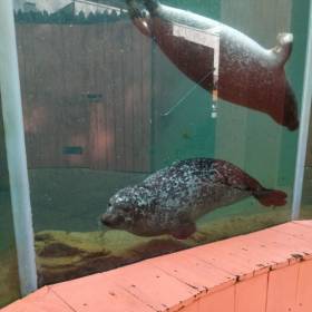
Two juvenile seals named Ariel and Merida after the Disney princesses are part of a novel marine research project using the latest technology to record and understand harbour seals’ behaviour.

In a first for Northern Ireland, the Exploris Aquarium in Portaferry, Co Down has teamed up with University College Cork as part of the EU-funded, Loughs Agency-led SeaMonitor project to tag the female rehabilitated seals prior to their release from Knockinelder Beach in Co Down yesterday (Sunday 17 November).

Although seal pups have been rehabilitated and released by Exploris since 1989, this is the first time they have been tracked following release to give scientists a better understanding of how they fair post-release.

‘Although seal pups have been rehabilitated by Exploris since 1989, this is the first time they have been tracked following release’

Dr Mark Jessop, lead scientist from UCC, said: “We use state-of-the-art tags glued to the seals’ fur which drop off naturally during the seal’s annual moult, but until then provide information on where the seals are going as well as their dive behaviour.

“This gives us unique insights into post-rehabilitation survival and how juvenile seals learn to forage successfully in the wild.”

It is hoped that the data will be used to inform better management and protection for harbour seals.

The release of the two seals marks the first this season from Exploris Aquarium, NI’s only seal rehabilitation facility — with more releases to come.

“On average we take in about two dozen seals every year,” said Exploris curator, Peter Williams. “Seals are a protected species here in the UK and Europe so at Exploris we take in seal pups from all over the Northern Irish coast that have succumb to illness or have been affected by human interference and as a result abandoned by their mothers.”

Loughs Agency chief executive Sharon McMahon added: “This is an especially exciting time as the seals are the first species to be monitored since the project launched earlier this year.

“The agency is proud to be leading the way alongside expert colleagues from statutory and academic institutions and a range of stakeholders that will ultimately produce dynamic management plans for some of our most important and vulnerable species.”

‘These achievements ensure the safeguarding of our shared marine environment’

Discussing the importance of this work, Gina McIntyre, CEO of the Special EU Programmes Body, said: “I’m delighted to hear about the progress of this pioneering EU INTERREG cross-border project, which has seen a tremendous amount of development in such a short space of time.

“These achievements ensure the safeguarding of our shared marine environment and continue the necessary conservation work to protect priority species and habitats just like Ariel and Merida.

“The significant progress so far can be attributed to the strong cross-border partnership, combined with innovative marine technology. The expertise and determination of SeaMonitor’s project partners is helping push the boundaries of marine research in the seas not only around Northern Ireland, but in Ireland and Western Scotland.”

The work is part of SeaMonitor — a unique marine research project, the first of its kind in Europe, studying the seas around Ireland, Western Scotland and Northern Ireland.

The project is led by the Loughs Agency and supported by another eight leading marine research institutions, using innovative marine species tracking technology to better understand and protect vulnerable marine life in our oceans.

Published in Marine Wildlife

General Information on using Waterways Ireland inland navigations

Safety on the Water

All users of the navigations are strongly recommended to make themselves aware of safety on the water for whatever activity they are involved in and to read the advice offered by the various governing bodies and by:

The Dept. of Transport, Ireland: www.gov.ie/transport and The Maritime and Coastguard Agency, UK, The RNLI – Water Safety Ireland for information in terms of drowning prevention and water safety.

Registration of Vessels

All vessels using the Shannon Navigation, which includes the Shannon-Erne Waterways and the Erne System must be registered with Waterways Ireland. Only open undecked boats with an engine of 15 horsepower or less on the Shannon Navigation, and vessels of 10 horsepower or less on the Erne System, are exempt. Registration is free of charge.

Craft registration should be completed online at: https://www.waterwaysireland.org/online-services/craft-registration

Permits for use of the Grand and Royal Canals and the Barrow Navigation

All vessels using the Grand and Royal Canals and the Barrow Navigation must display appropriate valid Permit(s) i.e A Combined Mooring and Passage Permit (€126) and if not intending to move every five days, an Extended Mooring Permit (€152).

Permit applications should be completed online at: https://www.waterwaysireland.org/online-services/canal-permits

Passage on the Royal and Grand Canals – Dublin Area

For boat passage through the locks east of Lock 12 into / out of Dublin on either the Royal or Grand Canals, Masters are requested to contact the Waterways Ireland Eastern Regional Office (M-F 9.30am-4.30pm) on tel: +353(0)1 868 0148 or email [email protected] prior to making passage in order to plan the necessary lock-keeping assistance arrangements.

On the Grand Canal a minimum of two days notice prior to the planned passage should be given, masters should note that with the exception of pre-arranged events, a maximum of 2 boats per day will be taken through the locks, travelling either east or west.

Movements in or out of the city will be organised by prior arrangement to take place as a single movement in one day. Boaters will be facilitated to travel the system if their passage is considered to be safe by Waterways Ireland and they have the valid permit(s) for mooring and passage.

Newcomen Lifting Bridge

On the Royal Canal two weeks’ notice of bridge passage (Newcomen Lifting Bridge) is required for the pre-set lift date, and lock assistance will then also be arranged. A minimum of 2 boats is required for a bridge lift to go ahead.

Waterways Ireland Eastern Regional Office (Tel: +353(0)1 868 0148 or [email protected] ) is the point of contact for the bridge lift.

A maximum number of boats passing will be implemented to keep to the times given above for the planned lifts (16 for the Sat / Sun lifts & 8 for the weekday lifts). Priority will be given on a first come first served basis.

On day of lift, boaters and passengers must follow guidance from Waterways Ireland staff about sequence of passage under bridge & through Lock 1, and must remain within signed and designated areas.

Events Held on the Waterways

All organised events taking place on the waterways must have the prior approval of Waterways Ireland. This is a twelve week process and application forms must be accompanied with the appropriate insurance, signed indemnity and risk assessment. The application should be completed on the Waterways Ireland events page at :

https://www.waterwaysireland.org/online-services/event-approval

Time Limits on Mooring in Public Harbours

On the Shannon Navigation and the Shannon-Erne Waterway craft may berth in public harbours for five consecutive days or a total of seven days in any one month.

On the Erne System, revised Bye Laws state that: No master or owner shall permit a vessel, boat or any floating or sunken object to remain moored at or in the vicinity of any public mooring, including mooring at any other public mooring within 3 kilometres of that location, for more than 3 consecutive days and shall not moor at that same mooring or any other public mooring within 3 kilometres of that location within the following 3 consecutive days without prior permission by an authorised official.

Winter Mooring on the Shannon Navigation and Shannon Erne Waterway

Winter mooring may be availed of by owners during the period 1 Nov to 31 Mar by prior arrangement and payment of a charge of €63.50 per craft. Craft not availing of Winter Mooring must continue to comply with the “5 Day Rule”. Winter Mooring applications should be completed online at : https://www.waterwaysireland.org/online-services/winter-moorings-booking

Owners should be aware that electricity supply and water supply to public moorings is disconnected for the winter months. This is to protect against frost damage, to reduce running costs and to minimise maintenance requirements during the winter months.

Vessel owners are advised that advance purchasing of electricity on the power bollards leading up to the disconnection date should be minimal. Electricity credit existing on the bollards will not be recoverable after the winter decommissioning date. Both services will be reinstated prior to the commencement of the next boating season.

Smart Cards

Waterways Ireland smart cards are used to operate locks on the Shannon Erne Waterway, to access the service blocks, to use the pump-outs along the navigations, to avail of electrical power at Waterways Ireland jetties.

Berthing in Public Harbours

Masters are reminded of the following:

  • Equip their vessel with mooring lines of appropriate length and strength and only secure their craft to mooring bollards and cleats provided for this purpose.
  • Ensure the available berth is suitable to the length of your vessel, do not overhang the mooring especially on finger moorings on floating pontoon moorings.
  • Ensure mooring lines, electric cables and fresh water hoses do not create a trip hazard on public jetties for others users.
  • Carry sufficient fenders to prevent damage to your own vessel, other vessels and WI property.
  • Allow sufficient space between your vessel and the vessel ahead /astern (c.1m) for fire safety purposes and /or to recover somebody from the water.
  • Do not berth more than two vessels side by side and ensure there is safe access/egress at all times between vessels and onto the harbour itself.
  • Do not berth in such a way to prevent use of harbour safety ladders, slipways or pump-outs.
  • Do not allow the bow of your vessel to overhang the walkway of a floating mooring thus creating a hazard for others with an overhanging anchor or bow fendering.
  • Animals are not allowed to be loose or stray at any time.
  • Harbour and jetty infrastructure such as railings, power pedestals, fresh water taps, electric light poles, safety bollards, ladders etc are not designed for the purpose of mooring craft , they will not bear the strain of a vessel and will be damaged.
  • At Carrybridge on the Erne System, Masters of vessels are not permitted to use stern on mooring. Masters of vessels must use the mooring fingers for mooring of vessels and for embarkation / disembarkation from vessels.

Passenger Vessel Berths

Masters of vessels should not berth on passenger vessel berths where it is indicated that an arrival is imminent. Passenger vessels plying the navigations generally only occupy the berths to embark and disembark passengers and rarely remain on the berths for extended periods or overnight.

Lock Lead-in Jetties

Lead-in jetties adjacent to the upstream and downstream gates at lock chambers are solely for the purpose of craft waiting to use the lock and should not be used for long term berthing.

Vessel Wake

Vessel wake, that is, the wave generated by the passage of the boat through the water, can sometimes be large, powerful and destructive depending on the hull shape and engine power of the vessel. This wake can be detrimental to other users of the navigation when it strikes their craft or inundates the shoreline or riverbank. Masters are requested to frequently look behind and check the effect of their wake / wash particularly when passing moored vessels, on entering harbours and approaching jetties and to be aware of people pursuing other activities such as fishing on the riverbank.

Speed Restriction

A vessel or boat shall not be navigated on the Shannon Navigation at a speed in excess of 5 kph when within 200 metres of a bridge, quay, jetty or wharf, when in a harbour or canal or when passing within 100 metres of a moored vessel or boat.

Vessels navigating the Shannon-Erne Waterway should observe the general 5 kph speed limit which applies along the waterway. This is necessary in order to prevent damage to the banks caused by excessive wash from vessels.

Vessels navigating the Erne System should observe the statutory 5kt / 6mph / 10kph speed limit areas.

A craft on the Royal and Grand canals shall not be navigated at a speed in excess of 6km per hour.

A craft on the Barrow Navigation shall not be navigated at a speed in excess of 11km per hour except as necessary for safe navigation in conditions of fast flow.

Bank Erosion

Narrow sections of all the navigations are particularly prone to bank erosion due to the large wash generated by some craft. Masters are requested to be vigilant and to slow down to a speed sufficient to maintain steerage when they observe the wash of their craft inundating the river banks.

Unusual Waterborne Activity

Unusual waterborne vessels may be encountered from time to time, such as, hovercraft or amphibious aircraft / seaplanes. Masters of such craft are reminded to apply the normal “Rule of the Road” when they meet conventional craft on the water and to allow extra room to manoeuvre in the interest of safety.

Sailing Activity

Mariners will encounter large numbers of sailing dinghies from late June to August in the vicinity of Lough Derg, Lough Ree and Lower Lough Erne. Sailing courses are marked by yellow buoys to suit weather conditions on the day. Vessels should proceed at slow speed and with due caution and observe the rules of navigation when passing these fleets, as many of the participants are junior sailors under training.

Rowing

Mariners should expect to meet canoes and vessels under oars on any part of the navigations, but more so in the vicinity of Athlone, Carrick-on-Shannon, Coleraine, Enniskillen and Limerick. Masters are reminded to proceed at slow speed and especially to reduce their wash to a minimum when passing these craft as they can be easily upset and swamped due to their very low freeboard and always be prepared to give way in any given traffic situation.

Canoeing

Canoeing is an adventure sport and participants are strongly recommended to seek the advice of the sport’s governing bodies i.e Canoeing Ireland and the Canoe Association of Northern Ireland, before venturing onto the navigations.

Persons in charge of canoes are reminded of the inherent danger to these craft associated with operating close to weirs, sluice gates, locks and other infrastructure particularly when rivers are in flood and large volumes of water are moving through the navigations due to general flood conditions or very heavy localised precipitation e.g. turbulent and broken water, stopper waves. Shooting weirs is prohibited without prior permission of Waterways Ireland.

Canoeists should check with lockkeepers prior entering a lock to ensure passage is done in a safe manner. Portage is required at all unmanned locks.

Canoe Trail Network – "Blueways"

Masters of powered craft are reminded that a canoe trail network is being developed across all navigations and to expect more organised canoeing along these trails necessitating slow speed and minimum wash when encountering canoeists, rowing boats etc

Rockingham and Drummans Island Canals – Lough Key

It is expected that work on Rockingham and Drummans Island Canals on Lough Key will be completed in 2021. Access to these canals will be for non-powered craft only, eg canoes, kayaks, rowing boats.

Fast Powerboats and Personal Watercraft (Jet Skis)

Masters of Fast Powerboats (speed greater than 17kts) and Personal Watercraft (i.e.Jet Skis) are reminded of the inherent dangers associated with high speed on the water and especially in the confines of small bays and narrow sections of the navigations. Keeping a proper look-out, making early alterations to course and /or reducing speed will avoid conflict with slower vessels using the navigation. Personal Watercraft are not permitted to be used on the canals.

Towing Waterskiers, Wakeboarders, Doughnuts etc

Masters of vessels engaged in any of these activities are reminded of the manoeuvring constraints imposed upon their vessel by the tow and of the added responsibilities that they have to the person(s) being towed. These activities should be conducted in areas which are clear of conflicting traffic. It is highly recommended that a person additional to the master be carried to act as a “look-out” to keep the tow under observation at all times.

Prohibition on Swimming

Swimming in the navigable channel, particularly at bridges, is dangerous and is prohibited due to the risk of being run over by a vessel underway in the navigation.

Age Restrictions on operating of powered craft

In the Republic of Ireland, Statutory Instrument 921 of 2005 provides the legal requirements regarding the minimum age for operating of powered craft. The Statutory Instrument contains the following requirements:

- The master or owner of a personal watercraft or a fast power craft shall take all reasonable steps to ensure that a person who has not attained the age of 16 years does not operate or control the craft

- The master or owner of a pleasure craft powered by an engine with a rating of more than 5 horse power or 3.7 kilowatts shall take all reasonable steps to ensure that a person who has not attained the age of 12 years does not operate or control the craft.

Lifejackets and Personal Flotation Devices (PFDs)

Lifejackets and PFD’s are the single most important items of personal protective equipment to be used on a vessel and should be worn especially when the vessel is being manoeuvred such as entering / departing a lock, anchoring, coming alongside or departing a jetty or quayside.

In the Republic of Ireland, Statutory Instrument 921 of 2005 provides the legal requirements regarding the wearing of Personal Flotation Devices. The Statutory Instrument contains the following requirements:

- The master or owner of a pleasure craft (other than a personal watercraft) shall ensure, that there are, at all times on board the craft, sufficient suitable personal flotation devices for each person on board.

- A person on a pleasure craft (other than a personal watercraft) of less than 7 metres length overall shall wear a suitable personal flotation device while on board an open craft or while on the deck of decked craft, other than when the craft is made fast to the shore or at anchor.

- The master or owner of a pleasure craft (other than a personal watercraft) shall take all reasonable steps to ensure that a person who has not attained the age of 16 years complies with paragraph above.

- The master or owner of a pleasure craft (other than a personal watercraft), shall take all reasonable steps to ensure that a person who has not attained the age of 16 years wears a suitable personal flotation device while on board an open craft or while on the deck of a decked craft other than when it is made fast to the shore or at anchor.

- The master or owner of a pleasure craft (other than a personal watercraft) shall take all reasonable steps to ensure that a person wears a suitable personal flotation device, at all times while – (a) being towed by the craft, (b) on board a vessel or object of any kind which is being towed by the craft.

Further information is available at: http://www.irishstatutebook.ie/eli/2005/si/921/made/en/print

Firing Range Danger Area – Lough Ree

The attention of mariners is drawn to the Irish Defence Forces Firing Range situated in the vicinity of buoys No’s 2 and 3, on Lough Ree on the Shannon Navigation. This range is used regularly for live firing exercises, throughout the year, all boats and vessels should stay clear of the area marked with yellow buoys showing a yellow "X" topmark and displaying the word "Danger".

Shannon Navigation, Portumna Swing Bridge Tolls

No attempt should be made by Masters’ of vessels to pay the bridge toll while making way through the bridge opening. Payment will only be taken by the Collector from Masters when they are secured alongside the jetties north and south of the bridge.

Navigating from Killaloe to Limerick on the Shannon Navigation

The navigation from Killaloe to Limerick involves passage through Ardnacrusha locks, the associated headrace and tailrace and the Abbey River into Limerick City. Careful passage planning is required to undertake this voyage. Considerations include: lock passage at Ardnacrusha, water flow in the navigation, airdraft under bridges on Abbey River in Limerick, state of tide in Limerick

Users are advised to contact the ESB Ardnacrusha hydroelectric power station (00353 (0)87 9970131) 48 hours in advance of commencing their journey to book passage through the locks at Ardnacrusha. It is NOT advised to undertake a voyage if more than one turbine is operating (20MW), due to the increased velocity of flow in the navigation channel, which can be dangerous. To ascertain automatically in real time how many turbines are running, users can phone +353 (0)87 6477229.

For safety reasons the ESB has advised that only powered craft with a capacity in excess of 5 knots are allowed to enter Ardnacrusha Headrace and Tailrace Canals.

Passage through Sarsfield Lock should be booked on +353-87-7972998, on the day prior to travel and it should be noted also that transit is not possible two hours either side of low water.

A Hydrographic survey in 2020 of the navigation channel revealed that the approach from Shannon Bridge to Sarsfield Lock and the Dock area has silted up. Masters of vessels and water users are advised to navigate to the Lock from Shannon bridge on a rising tide one or two hours before High Tide.

Lower Bann Navigation

The attention of all users is drawn to the “Users Code for the Lower Bann”, in particular to that section covering “Flow in the River” outlining the dangers for users both on the banks and in the navigation, associated with high flow rates when the river is in spate. Canoeists should consult and carry a copy of the “Lower Bann Canoe Trail” guide issued by the Canoe Association of Northern Ireland. Users should also contact the DfI Rivers Coleraine, who is responsible for regulating the flow rates on the river, for advisory information on the flow rates to be expected on any given day.

DfI Rivers Coleraine. Tel: 0044 28 7034 2357 Email: [email protected]

Lower Bann Navigation – Newferry – No wake zone

A No Wake Zone exists on the Lower Bann Navigation at Newferry. Masters of vessels are requested to proceed at a slow speed and create no wake while passing the jetties and slipways at Newferry.

Overhead Power Lines (OHPL) and Air draft

All Masters must be aware of the dangers associated with overhead power lines, in particular sailing vessels and workboats with cranes or large air drafts. Voyage planning is a necessity in order to identify the location of overhead lines crossing the navigation.

Overhead power line heights on the River Shannon are maintained at 12.6metres (40 feet) from Normal Summer level for that section of navigation, masters of vessels with a large air draft should proceed with caution and make additional allowances when water levels are high.

If a vessel or its equipment comes into contact with an OHPL the operator should NOT attempt to move the vessel or equipment. The conductor may still be alive or re-energise automatically. Maintain a safe distance and prevent third parties from approaching due to risk of arcing. Contact the emergency services for assistance.

Anglers are also reminded that a minimum ground distance of 30 metres should be maintained from overhead power lines when using a rod and line.

Submarine Cables and Pipes

Masters of vessels are reminded not to anchor their vessels in the vicinity of submarine cables or pipes in case they foul their anchor or damage the cables or pipes. Look to the river banks for signage indicating their presence.

Water Levels - Precautions

Low Water Levels:

When water levels fall below normal summer levels masters should be aware of:

Navigation

To reduce the risk of grounding masters should navigate on or near the centreline of the channel, avoid short cutting in dog-legged channels and navigating too close to navigation markers.

Proceeding at a slow speed will also reduce “squat” effect i.e. where the vessel tends to sit lower in the water as a consequence of higher speed.

Slipways

Reduced slipway length available under the water surface and the possibility of launching trailers dropping off the end of the concrete apron.

More slipway surface susceptible to weed growth requiring care while engaged in launching boats, from slipping and sliding on the slope. Note also that launching vehicles may not be able to get sufficient traction on the slipway once the craft is launched to get up the incline.

Bank Erosion

Very dry riverbanks are more susceptible to erosion from vessel wash.

Lock Share

Maximising on the number of vessels in a lock will ensure that the total volume of water moving downstream is decreased. Lock cycles should be used for vessels travelling each way.

High Water Levels:

When water levels rise above normal summer level masters should be aware of:

Navigation

Navigation marks will have reduced height above the water level or may disappear underwater altogether making the navigable channel difficult to discern.

In narrow sections of the navigations water levels will tend to rise more quickly than in main streams and air draft at bridges will likewise be reduced.

There will also be increased flow rates particularly in the vicinity of navigation infrastructure such as bridges, weirs, locks etc where extra care in manoeuvring vessels will be required.

Harbours and Jetties

Due care is required in harbours and at slipways when levels are at or near the same level as the harbour walkways' as the edge will be difficult to discern especially in reduced light conditions. It is advised that Personal Flotation Devices be worn if tending to craft in a harbour in these conditions.

Slipways

Slipways should only be used for the purpose of launching and recovering of water craft or other objects from the water. Before using a slipway it should be examined to ensure that the surface has sufficient traction/grip for the intended purpose such as launching a craft from a trailer using a vehicle, that there is sufficient depth of water on the slipway to float the craft off the trailer before the concrete apron ends and that the wheels of the trailer do not drop off the edge of the slipway. That life-saving appliances are available in the vicinity, that the vehicle is roadworthy and capable of coping with the weight of the trailer and boat on the incline. It is recommended that slipway operations are conducted by two persons.

Caution to be Used in Reliance upon Aids to Navigation

The aids to navigation depicted on the navigation guides comprise a system of fixed and floating aids to navigation. Prudent mariners will not rely solely on any single aid to navigation, particularly a floating aid to navigation. With respect to buoys, the buoy symbol is used to indicate the approximate position of the buoy body and the ground tackle which secures it to the lake or river bed. The approximate position is used because of the practical limitations in positioning and maintaining buoys in precise geographical locations. These limitations include, but are not limited to, prevailing atmospheric and lake/river conditions, the slope of and the material making up the lake/river bed, the fact that the buoys are moored to varying lengths of chain, and the fact that the buoy body and/or ground tackle positions are not under continuous surveillance. Due to the forces of nature, the position of the buoy body can be expected to shift inside and outside the charted symbol.

Buoys and perches are also moved out of position or pulled over by those mariners who use them to moor up to instead of anchoring. To this end, mariners should always monitor their passage by relating buoy/perch positions with the published navigation guide. Furthermore, a vessel attempting to pass close by always risks collision with a yawing buoy or with the obstruction that the buoy or beacon/perch marks.

Masters of Vessels are requested to use the most up to date Navigation guides when navigating on the Inland Waterways.

Information taken from Special Marine Notice No 1 of 2023