Menu

Ireland's sailing, boating & maritime magazine

Inland afloat headers


Displaying items by tag: Seabirds

The Minister for Housing, Local Government and Heritage has issued a direction regarding activities requiring prior ministerial approval within the site of the proposed special protection area (SPA) for seabirds in the North-West Irish Sea.

As reported earlier this year on Afloat.ie, the proposed new SPA will cover over 230,000 hectares extending out from Dublin Bay to as far north as Dunany Point in Co Louth, and will increase Ireland’s percentage of marine waters protected under the EU Birds and Habitats directive to over nine per cent.

The list of Activities Requiring Consent relating to the SPA includes the following:

  • Reclamation, including infilling.
  • Blasting, drilling, dredging or otherwise removing or disturbing fossils, rock, minerals, mud, sand, gravel or other sediment.
  • Introduction, or re-introduction, of plants or animals not found in the area. (Consent is not required for the planting of crops on established reseeded grassland or cultivated land.)
  • Undertaking scientific research involving the collection and removal of biological material.
  • Any activity intended to disturb birds, including by mechanical, air, gas, wind-powered or audible means.
  • Developing or consenting to the development or operation of commercial recreational/visitor facilities or organised recreational activities.
  • Undertaking active acoustic surveys in the marine environment.

Observations in relation to the classification of the site may be submitted by interested parties and must be supported by scientifically based ornithological criteria.

Any objections to the classification of the site as a SPA or the Ministerial Direction may be lodged with the National Parks and Wildlife service.

The closing date for receipt of any observations or objections is 19 February 2024 and further details are included in Marine Notice No 80 of 2023, attache below.

Published in Marine Wildlife
Tagged under

BirdWatch Ireland has said it is “shocked” at the spread of a highly virulent strain of avian flu in seabird colonies in Britain, and says Ireland needs to develop a response plan urgently.

No cases of highly pathogenic avian influenza (HPAI) have been positively identified in seabirds in the Republic of Ireland yet, but cases have been confirmed in several locations in Northern Ireland, it says.

The NGO is calling on the government to convene key stakeholders “urgently” with a view to developing and implementing a response plan to the growing threat of the spread in Ireland.

“We are witnessing the potential decimation of seabird populations on a scale that has not been seen before in our lifetimes. We are as a result gravely concerned for seabird colonies in Ireland,”Birdwatch Ireland says.

“We believe that it is only a matter of time before a wild bird is tested positive by Department of Agriculture, Food and Marine veterinary staff, but casual sightings indicate that the disease is probably present in our wild birds already,” it says.

“HPAI has the potential to spread rapidly in breeding seabird colonies, as seabirds gather in high numbers and in close proximity to lay eggs and rear chicks on Irish cliffs, headlands and islands,”it says.

Birdwatch Ireland stresses the international importance of Irish colonies, with Rockabill Island off the coast of Skerries in north County Dublin holding up to 80% of Europe’s breeding Roseate Terns.

The Kilcoole, County Wicklow Little Tern colony holds 40% of Ireland’s Little Tern population, it says, while Manx Shearwater occurs on just a handful of colonies.

Sites off the south-east such as Great Saltee island hold internationally important breeding seabird populations, including the gannet, which has been impacted particularly severely, it says.

It says that given that 23 of Ireland’s 24 breeding seabirds are already red or amber listed birds of conservation concern, with global threats to the puffin and kittiwake, the government here must act very quickly and take the HPAI threat seriously.

Birdwatch Ireland senior seabird conservation officer Dr Stephen Newton described the situation as “frightening”.

“There are three or four species where virtually the whole of the Irish, or sometimes the whole of the European, population nest at just one or two sites. Our big fear is that these could be wiped out completely,” Dr Newton says.

BirdWatch Ireland says that with the agreement of the National Parks and Wildlife Service it is ceasing research and monitoring activities at seabird colonies, where staff and volunteers would be in very close proximity to wild birds, except in exceptional circumstances.

“ This will help reduce disturbance and minimise the risk of spreading the disease,”it says.

“Our seabirds are the life and soul of the coastline in the summer. The Irish Government has a responsibility to protect them as much as possible from this deadly disease,”it says.

“HPAI originated in intensively manged poultry flocks and then infected wild birds. Putting in place measures which may help to minimise the spread in Ireland is essential to prevent further biodiversity loss, but also to protect poultry flocks which could be re-infected from the disease circulating in the wild bird population,”it says.

It advises anyone who sees a dead or distressed wild bird to report it to the Department of Agriculture, Fisheries and the Marine at https://aviancheck.apps.rhos.agriculture.gov.ie/report.

Published in Marine Wildlife
6th September 2017

Sailors & Seabirds

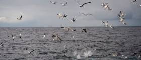
Seabirds and sailors have a long history together. They are reputed to have guided lost sailors to land, led fishermen to catch fish and the sight of them has encouraged many a despairing sailor to realise that land is nearby. From the time a small bird, obviously tired, came out of nowhere to land on NCB Ireland when I was crewing aboard in the then Whitbread Round the World Race, I have been fascinated by how birds fly huge distances over the oceans. That bird stayed for over a day and we were anxious to feed and give it water. Then, sometime in the early dawn it left, heading for I know not where. The legendary Albatross is perhaps the most well-known bird of the seas. Whenever I am sailing in Cork Harbour and see birds dive out of the sky, plunging into and below the water to catch fish, I watch fascinated. When seagulls were being accused of attacking humans in their search for food, it was tme a sign of food lacking at sea as they came inland.

Birdwatch Ireland is the organisation which protects Ireland's birds and their habitats. Fintan Kelly, Policy Officer at Birdwatch, told me this week on the podcast below that one of the most troubling indications of the state of the broader marine environment comes from research carried out on the behaviour of seabirds, because they are excellent indicators of what is happening at and in the sea.

As I said at the outset, seabirds and humans have a long history together, but many species of seabirds are threatened by human activities, which all of us sailors should be concerned about. So I urge you to listen to what Fintan Kelly has to say. You might just think a lot more about the next birds you encounter at sea.

Listen to him on the podcast below where you can also hear how Lifeguards prevented 16,316 marine accidents and keep up with the pace of life on the offshore islands which is quite hectic.

Tom MacSweeney presents This Island Nation maritime programme

Published in Tom MacSweeney
Tagged under

#MaritimeFestivals - The inaugural Cliffs of Moher Seabirds Festival will take place from 9 to 14 May at the famous Clare coastal attraction and in other locations around the Burren and Cliffs of Moher Geopark.

Over 60,000 seabirds can be seen at the Cliffs of Moher during the breeding season, including puffins, guillemots, razorbills, kittiwake and fulmar nesting a different levels of the cliffs.

The cliffs are a Special Protected Area for seabirds and are also home to other bird species such as peregrine falcons, choughs and ravens.

There is nowhere else on the mainland of Ireland where you can so easily see such a host of nesting seabirds from accessible viewing points on the grounds of the Cliffs of Moher Visitor Experience or from the boat of the Cliffs of Moher cruises from Doolin.

The Cliffs of Moher Seabirds Festival aims to celebrate the presence of "our feathered fishy friends" with a programme of family-friendly activities including 'seabird bingo', guided birdwatching and flight demonstrations.

More details can be found HERE on the latest addition to Ireland's maritime festivals.

Published in Maritime Festivals

#MarineWildlife - If you've ever wanted to get closer to Ireland's marine wildlife, a new series of weekend excursions in West Cork may be just the ticket.

The Southern Star reports on the 'Discover Wildlife Weekends' being run from Rosscarbery by local company Ireland's Wildlife starting this April, where those taking part will be led by expert guides to explore the coastal region and have the best opportunities to spot the many species of whales and dolphins that visit our shores.

Weather permitting, the weekends will also involve some offshore whale watching in the company of 'whale watch supremo' Colin Barnes and the Irish Whale and Dolphin Group's (IWDG) sightings co-ordinator Pádraig Whooley.

And birdwatching will also be a feature, as West Cork is a hotspot for our feathered friends - from merlins and peregrine falcons to coastal waders and more exotic fowl that skirt our coasts on their spring migrations.

The Southern Star has much more on the story HERE.

Meanwhile, marine sector stakeholders have expressed their concerns over the designation of six new offshore marine areas by the National Parks and Wildlife Service.

As previously reported on Afloat.ie, the six sites at Blackwater Bank in Wexford, the West Connacht coast, Hempton's Turbot Bank in Donegal, the Porcupine Bank Canyon off Kerry, the South-East Rockall Bank, and the stretch from Rockabill to Dalkey Island off Dublin have been proposed for designation as Special Areas of Conservation (SACs) to protect marine habitats and species listed on the 1992 EU Habitats Directive.

But at a recent meeting at the Irish Farm Centre in Dublin, a coalition of fish farmers, fishermen and marine energy stakeholders have hit out at what they characterise as "the appalling handling of inshore designations since the 1990s by the State", which they claim "has resulted in hundreds of job losses and a flight of serious investment" from Ireland's coastal areas.

“Our experience of the Irish Government’s application of the EU Habitats Directive has been a saga of mismanagement, foot dragging and buck-passing which has left over 500 fish farming licences in limbo for over 10 years and a backlog of red tape and bureaucracy which could see producers waiting until 2020 and beyond for simple renewals which are vital to underpin their businesses," said IFA aquaculture executive Richie Flynn.

"These new offshore SACs will have the same effect of preventing any fishing, marine energy or aquaculture being carried out in these areas if left in the hands of the same agencies to manage."

Published in Marine Wildlife

#MARINE WILDLIFE - The Gorey Guardian reports that the bodies of two grey seals were found washed up last week on Booley Bay beach, near Fethard-on-Sea in Co Wexford.

The two seal pups were found in an emaciated and malnourished state by a beach walker on 27 November.

According to Irish Whale and Dolphin Group chair Kevin MacCormick, dead seal strandings are not unusual at this time of year, particularly after stormy weather, and grey seals have an especially high mortality rate.

Tramua wounds and blood found on the seals were put down to predation by seabirds.

Published in Marine Wildlife
Wildlife on Rathlin Island could be under threat if oil-drilling licences are awarded in the area, the Belfast Telegraph reports.
The north Antrim coast has been earmarked as a site for potential oil exploration in the latest round of British Government licensing, despite the area being designated as both a Special Protection Area and a Special Area of Conservation.
Environmental experts have warned of the devastating effect that oil drilling could have on marine wildlife on Rathlin Island and the nearby coastline.
"We've seen off the coast of Aberdeenshire that no matter how careful the drilling, there is always the risk of a spill," said Claire Ferry of the RSPB.
"In this case the spill happened far away from any vulnerable wildlife colonies, but just imagine the impact if that oil was washing onto a globally important seabird colony."
The Belfast Telegraph has more on the story HERE.

Wildlife on Rathlin Island could be under threat if oil-drilling licences are awarded in the area, the Belfast Telegraph reports.

The north Antrim coast has been earmarked as a site for potential oil exploration in the latest round of British Government licensing, despite the area being designated as both a Special Protection Area and a Special Area of Conservation.

Environmental experts have warned of the devastating effect that oil drilling could have on marine wildlife on Rathlin Island and the nearby coastline.

"We've seen off the coast of Aberdeenshire that no matter how careful the drilling, there is always the risk of a spill," said Claire Ferry of the RSPB.

"In this case the spill happened far away from any vulnerable wildlife colonies, but just imagine the impact if that oil was washing onto a globally important seabird colony."

The Belfast Telegraph has more on the story HERE.

Published in Marine Wildlife
The public will have greater access to see shipping activity in the Port of Dublin, when a new boat-based tour of the country's busiest port starts tomorrow, writes Jehan Ashmore.
Titled the River Liffey & Port Tour, the 45-minute excursion is a partnership between Sea Safari Tours and the Dublin Port Company. Tours will operate from the pontoon where the M.V. Cill Airne floating river-restaurant and bar venue is berthed at the North Wall Quay. Cill Airne was built in the Liffey Dockyard nearly fifty years ago, where she forms part of the tours audio commentary covering the history and the present day.

In addition to cruising this stretch of the River Liffey alongside the 'Docklands' quarter, the tour RIB boat will pass downriver through the East-Link toll bridge where visitors will get closer views of the variety of vessels and calling cruise liners from other ports throughout the world.

There will be five daily tours beginning at 10.00am, 12.00pm, 2.00pm, 4.00pm and 6.00pm.Tickets cost €15.00 for adults, €12.50 for students and the charge for senior citizens and children is €10.00.

In addition Sea Safari operate a 'River Liffey' only tour, a Dublin Bay 'North' and 'South' tours which visit Howth Head, Baily Lighthouse, Ireland's Eye and to Dalkey Island and Killiney Bay, where both bay tours provide a chance to spot local marine wildlife of seals, porpoises and sea birds.

Published in Dublin Port
A new EU-funded project is tracking the movements of seabirds along the Atlantic coastlines of Ireland, the UK, France, Spain and Portugal.
The Future of the Atlantic Marine Environment (FAME) project aims to pinpoint areas that are important for Europe's seabirds. This knowledge may assist in the selection of marine conservation areas to protect declining species.
According to Surfbirds News, the researchers are taping tiny GPS trackers to the backs of seabirds, allowing the scientists to accurately pinpoint their movements between the birds' nesting colonies and the areas of sea they use to find food.
"Up to know we've known very little about the movements of these birds when they venture out to sea to find food," said seabird scientist Dr Ellie Owen. "But now, just when these birds need our help, we're on the cusp of filling this information void with vitally-important data."
Surfbird News has more on the story HERE.

A new EU-funded project is tracking the movements of seabirds along the Atlantic coastlines of Ireland, the UK, France, Spain and Portugal.

The Future of the Atlantic Marine Environment (FAME) project aims to pinpoint areas that are important for Europe's seabirds. This knowledge may assist in the selection of marine conservation areas to protect declining species.

According to Surfbirds News, the researchers are taping tiny GPS trackers to the backs of seabirds, allowing the scientists to accurately pinpoint their movements between the birds' nesting colonies and the areas of sea they use to find food.

"Up to now we've known very little about the movements of these birds when they venture out to sea to find food," said seabird scientist Dr Ellie Owen. "But now, just when these birds need our help, we're on the cusp of filling this information void with vitally-important data."

Surfbirds News has more on the story HERE.

Published in Marine Wildlife

Fastnet Line which runs the Cork-Swansea port route on the Celtic Sea, is assisting the charity MarineLife to monitor cetaceans, writes Jehan Ashmore.

The work of MarineLife is to survey the population trends and track the movements of dolphins, whales, porpoises and other wildlife. The research is undertaken onboard Fastnet Line's Julia (1981/21,699grt) and access to the ferry is provided free-of-charge to the wildlife-based charity.

During the months of July and August the ferry's schedule will allow for further opportunities to conduct daylight sightings of marine-life which is to be posted on MarineLife and Fastnet Line websites.

Adrian Shephard, Chairman of MarineLife Trustees, said: "The route from Swansea to Cork crosses a range of marine habitats and we hope it will generate many sightings of cetaceans and seabirds, including two important species we monitor, the white-beaked dolphin and the balearic shearwater".

In addition monitors recently observed fin whales, the second largest whale on the planet. Such sightings provide vital information and this will contribute to a better understanding of the distribution of cetaceans and other marine life in the Celtic Sea. To read more www.marine-life.org.uk

The first of four summertime surveys is to take place on 10 July. Overall the research by MarineLife is part of a larger project which also involves the use of other ferries operating in the Irish Sea and those serving on UK continental routes.

The 1,500 passenger / 325 car-carrying Julia sails year-round six times a week between September to June and from next month and during August the vessel will provide eight sailings per week. For fares and sailings schedules contact www.fastnetline.com

Published in Marine Science

General Information on using Waterways Ireland inland navigations

Safety on the Water

All users of the navigations are strongly recommended to make themselves aware of safety on the water for whatever activity they are involved in and to read the advice offered by the various governing bodies and by:

The Dept. of Transport, Ireland: www.gov.ie/transport and The Maritime and Coastguard Agency, UK, The RNLI – Water Safety Ireland for information in terms of drowning prevention and water safety.

Registration of Vessels

All vessels using the Shannon Navigation, which includes the Shannon-Erne Waterways and the Erne System must be registered with Waterways Ireland. Only open undecked boats with an engine of 15 horsepower or less on the Shannon Navigation, and vessels of 10 horsepower or less on the Erne System, are exempt. Registration is free of charge.

Craft registration should be completed online at: https://www.waterwaysireland.org/online-services/craft-registration

Permits for use of the Grand and Royal Canals and the Barrow Navigation

All vessels using the Grand and Royal Canals and the Barrow Navigation must display appropriate valid Permit(s) i.e A Combined Mooring and Passage Permit (€126) and if not intending to move every five days, an Extended Mooring Permit (€152).

Permit applications should be completed online at: https://www.waterwaysireland.org/online-services/canal-permits

Passage on the Royal and Grand Canals – Dublin Area

For boat passage through the locks east of Lock 12 into / out of Dublin on either the Royal or Grand Canals, Masters are requested to contact the Waterways Ireland Eastern Regional Office (M-F 9.30am-4.30pm) on tel: +353(0)1 868 0148 or email [email protected] prior to making passage in order to plan the necessary lock-keeping assistance arrangements.

On the Grand Canal a minimum of two days notice prior to the planned passage should be given, masters should note that with the exception of pre-arranged events, a maximum of 2 boats per day will be taken through the locks, travelling either east or west.

Movements in or out of the city will be organised by prior arrangement to take place as a single movement in one day. Boaters will be facilitated to travel the system if their passage is considered to be safe by Waterways Ireland and they have the valid permit(s) for mooring and passage.

Newcomen Lifting Bridge

On the Royal Canal two weeks’ notice of bridge passage (Newcomen Lifting Bridge) is required for the pre-set lift date, and lock assistance will then also be arranged. A minimum of 2 boats is required for a bridge lift to go ahead.

Waterways Ireland Eastern Regional Office (Tel: +353(0)1 868 0148 or [email protected] ) is the point of contact for the bridge lift.

A maximum number of boats passing will be implemented to keep to the times given above for the planned lifts (16 for the Sat / Sun lifts & 8 for the weekday lifts). Priority will be given on a first come first served basis.

On day of lift, boaters and passengers must follow guidance from Waterways Ireland staff about sequence of passage under bridge & through Lock 1, and must remain within signed and designated areas.

Events Held on the Waterways

All organised events taking place on the waterways must have the prior approval of Waterways Ireland. This is a twelve week process and application forms must be accompanied with the appropriate insurance, signed indemnity and risk assessment. The application should be completed on the Waterways Ireland events page at :

https://www.waterwaysireland.org/online-services/event-approval

Time Limits on Mooring in Public Harbours

On the Shannon Navigation and the Shannon-Erne Waterway craft may berth in public harbours for five consecutive days or a total of seven days in any one month.

On the Erne System, revised Bye Laws state that: No master or owner shall permit a vessel, boat or any floating or sunken object to remain moored at or in the vicinity of any public mooring, including mooring at any other public mooring within 3 kilometres of that location, for more than 3 consecutive days and shall not moor at that same mooring or any other public mooring within 3 kilometres of that location within the following 3 consecutive days without prior permission by an authorised official.

Winter Mooring on the Shannon Navigation and Shannon Erne Waterway

Winter mooring may be availed of by owners during the period 1 Nov to 31 Mar by prior arrangement and payment of a charge of €63.50 per craft. Craft not availing of Winter Mooring must continue to comply with the “5 Day Rule”. Winter Mooring applications should be completed online at : https://www.waterwaysireland.org/online-services/winter-moorings-booking

Owners should be aware that electricity supply and water supply to public moorings is disconnected for the winter months. This is to protect against frost damage, to reduce running costs and to minimise maintenance requirements during the winter months.

Vessel owners are advised that advance purchasing of electricity on the power bollards leading up to the disconnection date should be minimal. Electricity credit existing on the bollards will not be recoverable after the winter decommissioning date. Both services will be reinstated prior to the commencement of the next boating season.

Smart Cards

Waterways Ireland smart cards are used to operate locks on the Shannon Erne Waterway, to access the service blocks, to use the pump-outs along the navigations, to avail of electrical power at Waterways Ireland jetties.

Berthing in Public Harbours

Masters are reminded of the following:

  • Equip their vessel with mooring lines of appropriate length and strength and only secure their craft to mooring bollards and cleats provided for this purpose.
  • Ensure the available berth is suitable to the length of your vessel, do not overhang the mooring especially on finger moorings on floating pontoon moorings.
  • Ensure mooring lines, electric cables and fresh water hoses do not create a trip hazard on public jetties for others users.
  • Carry sufficient fenders to prevent damage to your own vessel, other vessels and WI property.
  • Allow sufficient space between your vessel and the vessel ahead /astern (c.1m) for fire safety purposes and /or to recover somebody from the water.
  • Do not berth more than two vessels side by side and ensure there is safe access/egress at all times between vessels and onto the harbour itself.
  • Do not berth in such a way to prevent use of harbour safety ladders, slipways or pump-outs.
  • Do not allow the bow of your vessel to overhang the walkway of a floating mooring thus creating a hazard for others with an overhanging anchor or bow fendering.
  • Animals are not allowed to be loose or stray at any time.
  • Harbour and jetty infrastructure such as railings, power pedestals, fresh water taps, electric light poles, safety bollards, ladders etc are not designed for the purpose of mooring craft , they will not bear the strain of a vessel and will be damaged.
  • At Carrybridge on the Erne System, Masters of vessels are not permitted to use stern on mooring. Masters of vessels must use the mooring fingers for mooring of vessels and for embarkation / disembarkation from vessels.

Passenger Vessel Berths

Masters of vessels should not berth on passenger vessel berths where it is indicated that an arrival is imminent. Passenger vessels plying the navigations generally only occupy the berths to embark and disembark passengers and rarely remain on the berths for extended periods or overnight.

Lock Lead-in Jetties

Lead-in jetties adjacent to the upstream and downstream gates at lock chambers are solely for the purpose of craft waiting to use the lock and should not be used for long term berthing.

Vessel Wake

Vessel wake, that is, the wave generated by the passage of the boat through the water, can sometimes be large, powerful and destructive depending on the hull shape and engine power of the vessel. This wake can be detrimental to other users of the navigation when it strikes their craft or inundates the shoreline or riverbank. Masters are requested to frequently look behind and check the effect of their wake / wash particularly when passing moored vessels, on entering harbours and approaching jetties and to be aware of people pursuing other activities such as fishing on the riverbank.

Speed Restriction

A vessel or boat shall not be navigated on the Shannon Navigation at a speed in excess of 5 kph when within 200 metres of a bridge, quay, jetty or wharf, when in a harbour or canal or when passing within 100 metres of a moored vessel or boat.

Vessels navigating the Shannon-Erne Waterway should observe the general 5 kph speed limit which applies along the waterway. This is necessary in order to prevent damage to the banks caused by excessive wash from vessels.

Vessels navigating the Erne System should observe the statutory 5kt / 6mph / 10kph speed limit areas.

A craft on the Royal and Grand canals shall not be navigated at a speed in excess of 6km per hour.

A craft on the Barrow Navigation shall not be navigated at a speed in excess of 11km per hour except as necessary for safe navigation in conditions of fast flow.

Bank Erosion

Narrow sections of all the navigations are particularly prone to bank erosion due to the large wash generated by some craft. Masters are requested to be vigilant and to slow down to a speed sufficient to maintain steerage when they observe the wash of their craft inundating the river banks.

Unusual Waterborne Activity

Unusual waterborne vessels may be encountered from time to time, such as, hovercraft or amphibious aircraft / seaplanes. Masters of such craft are reminded to apply the normal “Rule of the Road” when they meet conventional craft on the water and to allow extra room to manoeuvre in the interest of safety.

Sailing Activity

Mariners will encounter large numbers of sailing dinghies from late June to August in the vicinity of Lough Derg, Lough Ree and Lower Lough Erne. Sailing courses are marked by yellow buoys to suit weather conditions on the day. Vessels should proceed at slow speed and with due caution and observe the rules of navigation when passing these fleets, as many of the participants are junior sailors under training.

Rowing

Mariners should expect to meet canoes and vessels under oars on any part of the navigations, but more so in the vicinity of Athlone, Carrick-on-Shannon, Coleraine, Enniskillen and Limerick. Masters are reminded to proceed at slow speed and especially to reduce their wash to a minimum when passing these craft as they can be easily upset and swamped due to their very low freeboard and always be prepared to give way in any given traffic situation.

Canoeing

Canoeing is an adventure sport and participants are strongly recommended to seek the advice of the sport’s governing bodies i.e Canoeing Ireland and the Canoe Association of Northern Ireland, before venturing onto the navigations.

Persons in charge of canoes are reminded of the inherent danger to these craft associated with operating close to weirs, sluice gates, locks and other infrastructure particularly when rivers are in flood and large volumes of water are moving through the navigations due to general flood conditions or very heavy localised precipitation e.g. turbulent and broken water, stopper waves. Shooting weirs is prohibited without prior permission of Waterways Ireland.

Canoeists should check with lockkeepers prior entering a lock to ensure passage is done in a safe manner. Portage is required at all unmanned locks.

Canoe Trail Network – "Blueways"

Masters of powered craft are reminded that a canoe trail network is being developed across all navigations and to expect more organised canoeing along these trails necessitating slow speed and minimum wash when encountering canoeists, rowing boats etc

Rockingham and Drummans Island Canals – Lough Key

It is expected that work on Rockingham and Drummans Island Canals on Lough Key will be completed in 2021. Access to these canals will be for non-powered craft only, eg canoes, kayaks, rowing boats.

Fast Powerboats and Personal Watercraft (Jet Skis)

Masters of Fast Powerboats (speed greater than 17kts) and Personal Watercraft (i.e.Jet Skis) are reminded of the inherent dangers associated with high speed on the water and especially in the confines of small bays and narrow sections of the navigations. Keeping a proper look-out, making early alterations to course and /or reducing speed will avoid conflict with slower vessels using the navigation. Personal Watercraft are not permitted to be used on the canals.

Towing Waterskiers, Wakeboarders, Doughnuts etc

Masters of vessels engaged in any of these activities are reminded of the manoeuvring constraints imposed upon their vessel by the tow and of the added responsibilities that they have to the person(s) being towed. These activities should be conducted in areas which are clear of conflicting traffic. It is highly recommended that a person additional to the master be carried to act as a “look-out” to keep the tow under observation at all times.

Prohibition on Swimming

Swimming in the navigable channel, particularly at bridges, is dangerous and is prohibited due to the risk of being run over by a vessel underway in the navigation.

Age Restrictions on operating of powered craft

In the Republic of Ireland, Statutory Instrument 921 of 2005 provides the legal requirements regarding the minimum age for operating of powered craft. The Statutory Instrument contains the following requirements:

- The master or owner of a personal watercraft or a fast power craft shall take all reasonable steps to ensure that a person who has not attained the age of 16 years does not operate or control the craft

- The master or owner of a pleasure craft powered by an engine with a rating of more than 5 horse power or 3.7 kilowatts shall take all reasonable steps to ensure that a person who has not attained the age of 12 years does not operate or control the craft.

Lifejackets and Personal Flotation Devices (PFDs)

Lifejackets and PFD’s are the single most important items of personal protective equipment to be used on a vessel and should be worn especially when the vessel is being manoeuvred such as entering / departing a lock, anchoring, coming alongside or departing a jetty or quayside.

In the Republic of Ireland, Statutory Instrument 921 of 2005 provides the legal requirements regarding the wearing of Personal Flotation Devices. The Statutory Instrument contains the following requirements:

- The master or owner of a pleasure craft (other than a personal watercraft) shall ensure, that there are, at all times on board the craft, sufficient suitable personal flotation devices for each person on board.

- A person on a pleasure craft (other than a personal watercraft) of less than 7 metres length overall shall wear a suitable personal flotation device while on board an open craft or while on the deck of decked craft, other than when the craft is made fast to the shore or at anchor.

- The master or owner of a pleasure craft (other than a personal watercraft) shall take all reasonable steps to ensure that a person who has not attained the age of 16 years complies with paragraph above.

- The master or owner of a pleasure craft (other than a personal watercraft), shall take all reasonable steps to ensure that a person who has not attained the age of 16 years wears a suitable personal flotation device while on board an open craft or while on the deck of a decked craft other than when it is made fast to the shore or at anchor.

- The master or owner of a pleasure craft (other than a personal watercraft) shall take all reasonable steps to ensure that a person wears a suitable personal flotation device, at all times while – (a) being towed by the craft, (b) on board a vessel or object of any kind which is being towed by the craft.

Further information is available at: http://www.irishstatutebook.ie/eli/2005/si/921/made/en/print

Firing Range Danger Area – Lough Ree

The attention of mariners is drawn to the Irish Defence Forces Firing Range situated in the vicinity of buoys No’s 2 and 3, on Lough Ree on the Shannon Navigation. This range is used regularly for live firing exercises, throughout the year, all boats and vessels should stay clear of the area marked with yellow buoys showing a yellow "X" topmark and displaying the word "Danger".

Shannon Navigation, Portumna Swing Bridge Tolls

No attempt should be made by Masters’ of vessels to pay the bridge toll while making way through the bridge opening. Payment will only be taken by the Collector from Masters when they are secured alongside the jetties north and south of the bridge.

Navigating from Killaloe to Limerick on the Shannon Navigation

The navigation from Killaloe to Limerick involves passage through Ardnacrusha locks, the associated headrace and tailrace and the Abbey River into Limerick City. Careful passage planning is required to undertake this voyage. Considerations include: lock passage at Ardnacrusha, water flow in the navigation, airdraft under bridges on Abbey River in Limerick, state of tide in Limerick

Users are advised to contact the ESB Ardnacrusha hydroelectric power station (00353 (0)87 9970131) 48 hours in advance of commencing their journey to book passage through the locks at Ardnacrusha. It is NOT advised to undertake a voyage if more than one turbine is operating (20MW), due to the increased velocity of flow in the navigation channel, which can be dangerous. To ascertain automatically in real time how many turbines are running, users can phone +353 (0)87 6477229.

For safety reasons the ESB has advised that only powered craft with a capacity in excess of 5 knots are allowed to enter Ardnacrusha Headrace and Tailrace Canals.

Passage through Sarsfield Lock should be booked on +353-87-7972998, on the day prior to travel and it should be noted also that transit is not possible two hours either side of low water.

A Hydrographic survey in 2020 of the navigation channel revealed that the approach from Shannon Bridge to Sarsfield Lock and the Dock area has silted up. Masters of vessels and water users are advised to navigate to the Lock from Shannon bridge on a rising tide one or two hours before High Tide.

Lower Bann Navigation

The attention of all users is drawn to the “Users Code for the Lower Bann”, in particular to that section covering “Flow in the River” outlining the dangers for users both on the banks and in the navigation, associated with high flow rates when the river is in spate. Canoeists should consult and carry a copy of the “Lower Bann Canoe Trail” guide issued by the Canoe Association of Northern Ireland. Users should also contact the DfI Rivers Coleraine, who is responsible for regulating the flow rates on the river, for advisory information on the flow rates to be expected on any given day.

DfI Rivers Coleraine. Tel: 0044 28 7034 2357 Email: [email protected]

Lower Bann Navigation – Newferry – No wake zone

A No Wake Zone exists on the Lower Bann Navigation at Newferry. Masters of vessels are requested to proceed at a slow speed and create no wake while passing the jetties and slipways at Newferry.

Overhead Power Lines (OHPL) and Air draft

All Masters must be aware of the dangers associated with overhead power lines, in particular sailing vessels and workboats with cranes or large air drafts. Voyage planning is a necessity in order to identify the location of overhead lines crossing the navigation.

Overhead power line heights on the River Shannon are maintained at 12.6metres (40 feet) from Normal Summer level for that section of navigation, masters of vessels with a large air draft should proceed with caution and make additional allowances when water levels are high.

If a vessel or its equipment comes into contact with an OHPL the operator should NOT attempt to move the vessel or equipment. The conductor may still be alive or re-energise automatically. Maintain a safe distance and prevent third parties from approaching due to risk of arcing. Contact the emergency services for assistance.

Anglers are also reminded that a minimum ground distance of 30 metres should be maintained from overhead power lines when using a rod and line.

Submarine Cables and Pipes

Masters of vessels are reminded not to anchor their vessels in the vicinity of submarine cables or pipes in case they foul their anchor or damage the cables or pipes. Look to the river banks for signage indicating their presence.

Water Levels - Precautions

Low Water Levels:

When water levels fall below normal summer levels masters should be aware of:

Navigation

To reduce the risk of grounding masters should navigate on or near the centreline of the channel, avoid short cutting in dog-legged channels and navigating too close to navigation markers.

Proceeding at a slow speed will also reduce “squat” effect i.e. where the vessel tends to sit lower in the water as a consequence of higher speed.

Slipways

Reduced slipway length available under the water surface and the possibility of launching trailers dropping off the end of the concrete apron.

More slipway surface susceptible to weed growth requiring care while engaged in launching boats, from slipping and sliding on the slope. Note also that launching vehicles may not be able to get sufficient traction on the slipway once the craft is launched to get up the incline.

Bank Erosion

Very dry riverbanks are more susceptible to erosion from vessel wash.

Lock Share

Maximising on the number of vessels in a lock will ensure that the total volume of water moving downstream is decreased. Lock cycles should be used for vessels travelling each way.

High Water Levels:

When water levels rise above normal summer level masters should be aware of:

Navigation

Navigation marks will have reduced height above the water level or may disappear underwater altogether making the navigable channel difficult to discern.

In narrow sections of the navigations water levels will tend to rise more quickly than in main streams and air draft at bridges will likewise be reduced.

There will also be increased flow rates particularly in the vicinity of navigation infrastructure such as bridges, weirs, locks etc where extra care in manoeuvring vessels will be required.

Harbours and Jetties

Due care is required in harbours and at slipways when levels are at or near the same level as the harbour walkways' as the edge will be difficult to discern especially in reduced light conditions. It is advised that Personal Flotation Devices be worn if tending to craft in a harbour in these conditions.

Slipways

Slipways should only be used for the purpose of launching and recovering of water craft or other objects from the water. Before using a slipway it should be examined to ensure that the surface has sufficient traction/grip for the intended purpose such as launching a craft from a trailer using a vehicle, that there is sufficient depth of water on the slipway to float the craft off the trailer before the concrete apron ends and that the wheels of the trailer do not drop off the edge of the slipway. That life-saving appliances are available in the vicinity, that the vehicle is roadworthy and capable of coping with the weight of the trailer and boat on the incline. It is recommended that slipway operations are conducted by two persons.

Caution to be Used in Reliance upon Aids to Navigation

The aids to navigation depicted on the navigation guides comprise a system of fixed and floating aids to navigation. Prudent mariners will not rely solely on any single aid to navigation, particularly a floating aid to navigation. With respect to buoys, the buoy symbol is used to indicate the approximate position of the buoy body and the ground tackle which secures it to the lake or river bed. The approximate position is used because of the practical limitations in positioning and maintaining buoys in precise geographical locations. These limitations include, but are not limited to, prevailing atmospheric and lake/river conditions, the slope of and the material making up the lake/river bed, the fact that the buoys are moored to varying lengths of chain, and the fact that the buoy body and/or ground tackle positions are not under continuous surveillance. Due to the forces of nature, the position of the buoy body can be expected to shift inside and outside the charted symbol.

Buoys and perches are also moved out of position or pulled over by those mariners who use them to moor up to instead of anchoring. To this end, mariners should always monitor their passage by relating buoy/perch positions with the published navigation guide. Furthermore, a vessel attempting to pass close by always risks collision with a yawing buoy or with the obstruction that the buoy or beacon/perch marks.

Masters of Vessels are requested to use the most up to date Navigation guides when navigating on the Inland Waterways.

Information taken from Special Marine Notice No 1 of 2023