Menu

Ireland's sailing, boating & maritime magazine

Inland afloat headers


Displaying items by tag: Shannon Blueway

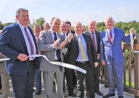
The third phase of the Shannon Blueway has been opened by Michael Ring, Minister for Rural and Community Development, in the company of Waterways Ireland’s acting chief executive John McDonagh and Leitrim County Council Cathaoirleach Enda McGloin.

The project has created a new path along the shores of Lough Allen linking four tourism businesses to the lock at Blackrock and Drumshanbo town and increasing access for walkers, cyclists and horseriders.

This involved the upgrade of 1km of an existing pathway along the Lough Allen canal between Acres Cove Marina and Drumshanbo Lock at Blackrock, and the installation of a new controlled pedestrian crossing on the R208, the only road crossing on this section.

Car parking for 13 vehicles has also been created, with a new entrance to Drumshanbo Lock at Blackrock and the newly developed Blueway.

The new section of Blueway path runs north from this point along the shores of Lough Allen, and includes a pedestrian bridge across the Millrace River connecting the town with a range of existing amenities.

Funding for the project was obtained by a partnership of Waterways Ireland and Leitrim County Council under the Outdoor Recreational Infrastructure Scheme through the Department of Rural and Community Development.

A total of €340,000 of Outdoor Recreational Infrastructure funding has been match-funded with €86,000 by Waterways Ireland.

Minister Ring said: “I am delighted to launch Phase 3 of the Shannon Blueway here in Leitrim. This will build on the success of Phases 1 and 2 of this project which were supported by my Department and which have brought 100,000 new visitors to this rural area, creating opportunities for business growth, new businesses and jobs.

“Phase 3 links a further four existing business to the Blueway and will be instrumental in increasing the time and money people spend in this area. This has been a wonderful collaborative effort between my Department, Waterways Ireland and Leitrim County Council.”

John McDonagh added: “Blueways are an excellent way of linking the waterways and paths we manage with tourism businesses and recreation clubs providing opportunities for people to experience the outdoors, nature and adventure.”

Waterways Ireland says the Shannon Blueway has proved to be a catalyst for ongoing rural development, social inclusion and job creation, and had so far led to the establishment of eight water-based recreational businesses.

In 2018 alone, 100,000 visitors used the Blueway facilities at Acres Lake, which are utilised for numerous sporting and charitable events, as a community resource and public asset.

The opening in Leitrim comes in the same week as the launch of a new development guide and accreditation scheme for Blueway development on the island of Ireland.

This initiative sees a number of State agencies working in partnership on an all-island basis to see the development of Blueway sites in the Republic of Ireland and Northern Ireland over the coming years.

More information on Blueway development is available HERE.

Published in Inland Waterways

#InlandWaters - The floating boardwalk at Acres Lake in Co Leitrim — a first for Ireland — is now open, completing the final leg of the Shannon Blueway.

Afloat.ie previously reported on the project in Drumshanbo when current Rural Development Minister Michael Ring visited the site to meet with Waterways Ireland staff last December, in his previous capacity as Minister of State for Regional Economic Development.

The 600m Blueway Boardwalk between Drumshanbo and Carrick-on-Shannon completes a 14km section of the blueway and connects it to a near 200km network of paths for walkers and cyclists across the waterways of Leitrim, Roscommon, Longford and Cavan.

Minister Ring described the €500,000 project as “an excellent investment” when he attended its opening yesterday (Tuesday 5 September).

A further €1.1 million has been allocated for a new walking and cycleway from Carrick-on-Shannon to Leitrim village and between Acres Lake and the Lough Allen Hotel, according to The Irish Times.

Published in Inland Waterways

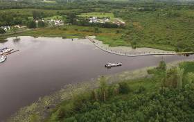
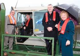
Minister Ring T.D. has awarded €500,000 to Waterways Ireland for the completion of the Shannon Blueway between Leitrim Village and Drumshanbo town. The project will include an iconic boardwalk around the southern side of Acres Lake. The attractive new walkway will be constructed partly on land and a significant section will be designed to float over the water. This work will complete a 14–km section of the Blueway, bringing it into the Blueway network which is now nearing 200km in length running across Leitrim, Roscommon, Longford and Cavan.

The Shannon Blueway is a new recreation and tourism concept that has been developed by Waterways Ireland and a number of key partners including Leitrim, Roscommon and Longford County Councils, the National Trails Office and Canoeing Ireland.

The Blueway is a series of quality multi-leisure activity trails both on and off water that offers a wider and deeper experience through associated activities and attractions. There are now 8 activity providers operating on the Blueway and accommodation & hospitality sector in the wider geographical area developing interesting and exciting packages for families and friends to experience. (www.bluewaysireland.org)

The first section of Blueway (funded by the Rural Recreation Grant Aid) opened in October 2014 and has achieved huge success and recognition to date. It comprises 3 looped walks and 16km of canoe trails connecting Carrick-on Shannon to Drumshanbo. It has already received two awards and has attracted over 100,000 visitors since opening.

The grant approved by Minister Ring T.D., will provide a critical connection in the walking and cycling element of the Blueway. The iconic boardwalk provides linkage for the existing 14km of looped walks to the facilities and services at Acres Lake and Drumshanbo town another key element of Blueway infrastructure.

Waterways Ireland and Leitrim County Council, manage and operate a fully serviced community and boating resource at Acres lake which includes a marina, car-parking, toilets and showers, outdoor swimming pool, tennis courts, angling facilities and the Sliabh an Iairann Visitor Centre. By connecting these facilities to the existing looped walk and cycle path the area can be utilised as a trail head and will anchor and integrate the Blueway in the town of Drumshanbo and the wider Roscommon and Leitrim hinterland

The project will involve the construction of a path from the current terminus near Drumhauver Bridge to the edge of Acres Lake; the procurement and installation of the floating walkway, and the construction of a new path linking the walkway to the services at Acres Lake. It is anticipated geotechnical works and preliminary site works will commence by the end of November 2016. Waterways Ireland is in the process of procuring the floating walkway. The scheme is expected to be completed by May 2017 in time for the main boating and tourist season.

Published in Inland Waterways

#InlandWaters - Quayside enhancements at Lanesborough-Ballyleague are part of a new project to develop facilities along the award-winning Shannon Blueway.

The Flagship REDZ project was submitted by Leitrim County Council on behalf of the Upper Shannon ​Erne Future Economy (USEFE) project partners, which include Bord Na Mona, ESB and Cavan, Leitrim, Longford and Roscommon Local Authorities in conjunction with Waterways Ireland.

The aim of this project is to develop the Shannon Blueway to support the wider economic development of the towns and villages along the Shannon and Erne Waterways.

The blueway is a developing a multi-activity trail running alongside the water which links walking, cycling, canoeing, paddle boarding, angling and cruising with local amenities.

​Twenty-two towns and villages in the Upper Shannon-Erne region are inter-connected by the Shannon and linked canals, providing what Waterways Ireland describes as "a unique opportunity to develop the blueway concept".

​As part of the objectives of the REDZ Flagship project for the Shannon Blueway, the quayside improvements at Lanesborough-Ballyleague will be joined by an extension of the looped walks from Drumleague to Drumhauver, a multi-leisure section of the blueway from Carrick-on-Shannon to Drumshanbo.

Click HERE to view a Facebook gallery​​ dedicated to the quayside improvements in Lanesborough-Ballyleague.

Published in Inland Waterways

#InlandWaters - The Shannon Blueway initiative received its second major award of the year at a star-studded event in Limerick's Thomond Park recently.

The European Sports Tourism Innovation Award was presented by Ireland's 6 Nations winning captain Paul O'Connell and Keith Wood of W2 Consulting to the Shannon Blueway partners Leitrim Tourism and Waterways Ireland at the prestigious European Sports Tourism Summit Awards on 14 May last.

Launched in October 2014, the Shannon Blueway is the first of its kind in Ireland where a myriad of recreational activities have been developed and bundled together as a single or multiple visitor experience and tourism proposition.

Waterways Ireland has developed and built a canoe trail from Drumshanbo through Battlebridge and Leitrim village to Carrick-on-Shannon. It has also developed a series of looped walks adjacent to the Lough Allen Canal, with plans to expand those walks to Drumshanbo and Carrick on Shannon.

At the same time, Waterways Ireland is also developing a canoe trail from Leitrim village along the 63km of the Shannon Erne Waterway with a walking and cycling trail also at an advanced stage of planning.

The wider Shannon Blueway, of which the Drumshanbo to Carrick-on-Shannon section is part, is at the heart of access to 100km of paddling area, six looped walks (three of which are on the canal towpath), two long-distance walks and three heritage trails. The blueway will ultimately provide access to 14 towns and services with each access point and town within an hours' paddling time. 

The Shannon Blueway is being delivered by Waterways Ireland in partnership of the Irish Sports Council, Canoeing Ireland, Leitrim County Council, Leitrim Tourism and Fáilte Ireland.

Chief executive Dawn Livingstone confirmed that partnership was the key to delivering the Shannon Blueway.

"Waterways Ireland has invested significantly in creating world beating facilities and services on the Shannon Navigation and is delighted to see this initiative recognised with the European Sports Tourism Innovation award.

"Through our partnership with the National Trails Office, Canoeing Ireland, Leitrim Tourism and Leitrim County Council an outstanding multi-activity product has been built in the Shannon Blueway which is now being packaged by clubs and communities for their recreational activities and companies and organisations for domestic and international tourists. Partnership is key to delivering the future of the Shannon Blueway further into Leitrim and into Roscommon, Longford and Cavan."

Frank Curran, CEO of Leitrim County Council, said that the Shannon Blueway "represents an excellent product that has been developed through collaboration between Waterways Ireland and Leitrim County Council to facilitate the development of this signature tourism offering for Co Leitrim and the region."

The European Sports Tourism Innovation Award is the second prize this year for the inland waterways initiative, after taking the Best Tourism Initiative category of the 2015 Community and Council Awards in January.

Published in Inland Waterways

#InlandWaters - The Shannon Blueway has won the Best Tourism Initiative category of the 2015 Community and Council Awards presented by LAMA in association with IPB.

Waterways Ireland – which have led the development of the Shannon Blueway – attended the ceremony represented by Norma Herron, with Leitrim County Council cathoirleach Paddy O'Rourke and chief executive Frank Curran.

The Shannon Blueway is a multi-activity trail running alongside water, linking walking, cycling, canoeing, paddle-boarding, angling and cruising with local towns and villages.

Launched in October 2014, thousands of walkers, paddlers and cyclists have already enjoyed this first section of the trail from Drumshanbo to Carrick-on-Shannon, including 16.5km of canoe trail and 10km of approved walking route.

And the route is already growing, with new sections to be opened later this year on the Camlin River.

The Shannon Blueway is being delivered in partnership with the National Trails Office, Canoeing Union, Leitrim County Council and Leitrim Tourism and is being marketed under the Blueways Ireland banner on the web, Facebook and Twitter.

Published in Inland Waterways

General Information on using Waterways Ireland inland navigations

Safety on the Water

All users of the navigations are strongly recommended to make themselves aware of safety on the water for whatever activity they are involved in and to read the advice offered by the various governing bodies and by:

The Dept. of Transport, Ireland: www.gov.ie/transport and The Maritime and Coastguard Agency, UK, The RNLI – Water Safety Ireland for information in terms of drowning prevention and water safety.

Registration of Vessels

All vessels using the Shannon Navigation, which includes the Shannon-Erne Waterways and the Erne System must be registered with Waterways Ireland. Only open undecked boats with an engine of 15 horsepower or less on the Shannon Navigation, and vessels of 10 horsepower or less on the Erne System, are exempt. Registration is free of charge.

Craft registration should be completed online at: https://www.waterwaysireland.org/online-services/craft-registration

Permits for use of the Grand and Royal Canals and the Barrow Navigation

All vessels using the Grand and Royal Canals and the Barrow Navigation must display appropriate valid Permit(s) i.e A Combined Mooring and Passage Permit (€126) and if not intending to move every five days, an Extended Mooring Permit (€152).

Permit applications should be completed online at: https://www.waterwaysireland.org/online-services/canal-permits

Passage on the Royal and Grand Canals – Dublin Area

For boat passage through the locks east of Lock 12 into / out of Dublin on either the Royal or Grand Canals, Masters are requested to contact the Waterways Ireland Eastern Regional Office (M-F 9.30am-4.30pm) on tel: +353(0)1 868 0148 or email [email protected] prior to making passage in order to plan the necessary lock-keeping assistance arrangements.

On the Grand Canal a minimum of two days notice prior to the planned passage should be given, masters should note that with the exception of pre-arranged events, a maximum of 2 boats per day will be taken through the locks, travelling either east or west.

Movements in or out of the city will be organised by prior arrangement to take place as a single movement in one day. Boaters will be facilitated to travel the system if their passage is considered to be safe by Waterways Ireland and they have the valid permit(s) for mooring and passage.

Newcomen Lifting Bridge

On the Royal Canal two weeks’ notice of bridge passage (Newcomen Lifting Bridge) is required for the pre-set lift date, and lock assistance will then also be arranged. A minimum of 2 boats is required for a bridge lift to go ahead.

Waterways Ireland Eastern Regional Office (Tel: +353(0)1 868 0148 or [email protected] ) is the point of contact for the bridge lift.

A maximum number of boats passing will be implemented to keep to the times given above for the planned lifts (16 for the Sat / Sun lifts & 8 for the weekday lifts). Priority will be given on a first come first served basis.

On day of lift, boaters and passengers must follow guidance from Waterways Ireland staff about sequence of passage under bridge & through Lock 1, and must remain within signed and designated areas.

Events Held on the Waterways

All organised events taking place on the waterways must have the prior approval of Waterways Ireland. This is a twelve week process and application forms must be accompanied with the appropriate insurance, signed indemnity and risk assessment. The application should be completed on the Waterways Ireland events page at :

https://www.waterwaysireland.org/online-services/event-approval

Time Limits on Mooring in Public Harbours

On the Shannon Navigation and the Shannon-Erne Waterway craft may berth in public harbours for five consecutive days or a total of seven days in any one month.

On the Erne System, revised Bye Laws state that: No master or owner shall permit a vessel, boat or any floating or sunken object to remain moored at or in the vicinity of any public mooring, including mooring at any other public mooring within 3 kilometres of that location, for more than 3 consecutive days and shall not moor at that same mooring or any other public mooring within 3 kilometres of that location within the following 3 consecutive days without prior permission by an authorised official.

Winter Mooring on the Shannon Navigation and Shannon Erne Waterway

Winter mooring may be availed of by owners during the period 1 Nov to 31 Mar by prior arrangement and payment of a charge of €63.50 per craft. Craft not availing of Winter Mooring must continue to comply with the “5 Day Rule”. Winter Mooring applications should be completed online at : https://www.waterwaysireland.org/online-services/winter-moorings-booking

Owners should be aware that electricity supply and water supply to public moorings is disconnected for the winter months. This is to protect against frost damage, to reduce running costs and to minimise maintenance requirements during the winter months.

Vessel owners are advised that advance purchasing of electricity on the power bollards leading up to the disconnection date should be minimal. Electricity credit existing on the bollards will not be recoverable after the winter decommissioning date. Both services will be reinstated prior to the commencement of the next boating season.

Smart Cards

Waterways Ireland smart cards are used to operate locks on the Shannon Erne Waterway, to access the service blocks, to use the pump-outs along the navigations, to avail of electrical power at Waterways Ireland jetties.

Berthing in Public Harbours

Masters are reminded of the following:

  • Equip their vessel with mooring lines of appropriate length and strength and only secure their craft to mooring bollards and cleats provided for this purpose.
  • Ensure the available berth is suitable to the length of your vessel, do not overhang the mooring especially on finger moorings on floating pontoon moorings.
  • Ensure mooring lines, electric cables and fresh water hoses do not create a trip hazard on public jetties for others users.
  • Carry sufficient fenders to prevent damage to your own vessel, other vessels and WI property.
  • Allow sufficient space between your vessel and the vessel ahead /astern (c.1m) for fire safety purposes and /or to recover somebody from the water.
  • Do not berth more than two vessels side by side and ensure there is safe access/egress at all times between vessels and onto the harbour itself.
  • Do not berth in such a way to prevent use of harbour safety ladders, slipways or pump-outs.
  • Do not allow the bow of your vessel to overhang the walkway of a floating mooring thus creating a hazard for others with an overhanging anchor or bow fendering.
  • Animals are not allowed to be loose or stray at any time.
  • Harbour and jetty infrastructure such as railings, power pedestals, fresh water taps, electric light poles, safety bollards, ladders etc are not designed for the purpose of mooring craft , they will not bear the strain of a vessel and will be damaged.
  • At Carrybridge on the Erne System, Masters of vessels are not permitted to use stern on mooring. Masters of vessels must use the mooring fingers for mooring of vessels and for embarkation / disembarkation from vessels.

Passenger Vessel Berths

Masters of vessels should not berth on passenger vessel berths where it is indicated that an arrival is imminent. Passenger vessels plying the navigations generally only occupy the berths to embark and disembark passengers and rarely remain on the berths for extended periods or overnight.

Lock Lead-in Jetties

Lead-in jetties adjacent to the upstream and downstream gates at lock chambers are solely for the purpose of craft waiting to use the lock and should not be used for long term berthing.

Vessel Wake

Vessel wake, that is, the wave generated by the passage of the boat through the water, can sometimes be large, powerful and destructive depending on the hull shape and engine power of the vessel. This wake can be detrimental to other users of the navigation when it strikes their craft or inundates the shoreline or riverbank. Masters are requested to frequently look behind and check the effect of their wake / wash particularly when passing moored vessels, on entering harbours and approaching jetties and to be aware of people pursuing other activities such as fishing on the riverbank.

Speed Restriction

A vessel or boat shall not be navigated on the Shannon Navigation at a speed in excess of 5 kph when within 200 metres of a bridge, quay, jetty or wharf, when in a harbour or canal or when passing within 100 metres of a moored vessel or boat.

Vessels navigating the Shannon-Erne Waterway should observe the general 5 kph speed limit which applies along the waterway. This is necessary in order to prevent damage to the banks caused by excessive wash from vessels.

Vessels navigating the Erne System should observe the statutory 5kt / 6mph / 10kph speed limit areas.

A craft on the Royal and Grand canals shall not be navigated at a speed in excess of 6km per hour.

A craft on the Barrow Navigation shall not be navigated at a speed in excess of 11km per hour except as necessary for safe navigation in conditions of fast flow.

Bank Erosion

Narrow sections of all the navigations are particularly prone to bank erosion due to the large wash generated by some craft. Masters are requested to be vigilant and to slow down to a speed sufficient to maintain steerage when they observe the wash of their craft inundating the river banks.

Unusual Waterborne Activity

Unusual waterborne vessels may be encountered from time to time, such as, hovercraft or amphibious aircraft / seaplanes. Masters of such craft are reminded to apply the normal “Rule of the Road” when they meet conventional craft on the water and to allow extra room to manoeuvre in the interest of safety.

Sailing Activity

Mariners will encounter large numbers of sailing dinghies from late June to August in the vicinity of Lough Derg, Lough Ree and Lower Lough Erne. Sailing courses are marked by yellow buoys to suit weather conditions on the day. Vessels should proceed at slow speed and with due caution and observe the rules of navigation when passing these fleets, as many of the participants are junior sailors under training.

Rowing

Mariners should expect to meet canoes and vessels under oars on any part of the navigations, but more so in the vicinity of Athlone, Carrick-on-Shannon, Coleraine, Enniskillen and Limerick. Masters are reminded to proceed at slow speed and especially to reduce their wash to a minimum when passing these craft as they can be easily upset and swamped due to their very low freeboard and always be prepared to give way in any given traffic situation.

Canoeing

Canoeing is an adventure sport and participants are strongly recommended to seek the advice of the sport’s governing bodies i.e Canoeing Ireland and the Canoe Association of Northern Ireland, before venturing onto the navigations.

Persons in charge of canoes are reminded of the inherent danger to these craft associated with operating close to weirs, sluice gates, locks and other infrastructure particularly when rivers are in flood and large volumes of water are moving through the navigations due to general flood conditions or very heavy localised precipitation e.g. turbulent and broken water, stopper waves. Shooting weirs is prohibited without prior permission of Waterways Ireland.

Canoeists should check with lockkeepers prior entering a lock to ensure passage is done in a safe manner. Portage is required at all unmanned locks.

Canoe Trail Network – "Blueways"

Masters of powered craft are reminded that a canoe trail network is being developed across all navigations and to expect more organised canoeing along these trails necessitating slow speed and minimum wash when encountering canoeists, rowing boats etc

Rockingham and Drummans Island Canals – Lough Key

It is expected that work on Rockingham and Drummans Island Canals on Lough Key will be completed in 2021. Access to these canals will be for non-powered craft only, eg canoes, kayaks, rowing boats.

Fast Powerboats and Personal Watercraft (Jet Skis)

Masters of Fast Powerboats (speed greater than 17kts) and Personal Watercraft (i.e.Jet Skis) are reminded of the inherent dangers associated with high speed on the water and especially in the confines of small bays and narrow sections of the navigations. Keeping a proper look-out, making early alterations to course and /or reducing speed will avoid conflict with slower vessels using the navigation. Personal Watercraft are not permitted to be used on the canals.

Towing Waterskiers, Wakeboarders, Doughnuts etc

Masters of vessels engaged in any of these activities are reminded of the manoeuvring constraints imposed upon their vessel by the tow and of the added responsibilities that they have to the person(s) being towed. These activities should be conducted in areas which are clear of conflicting traffic. It is highly recommended that a person additional to the master be carried to act as a “look-out” to keep the tow under observation at all times.

Prohibition on Swimming

Swimming in the navigable channel, particularly at bridges, is dangerous and is prohibited due to the risk of being run over by a vessel underway in the navigation.

Age Restrictions on operating of powered craft

In the Republic of Ireland, Statutory Instrument 921 of 2005 provides the legal requirements regarding the minimum age for operating of powered craft. The Statutory Instrument contains the following requirements:

- The master or owner of a personal watercraft or a fast power craft shall take all reasonable steps to ensure that a person who has not attained the age of 16 years does not operate or control the craft

- The master or owner of a pleasure craft powered by an engine with a rating of more than 5 horse power or 3.7 kilowatts shall take all reasonable steps to ensure that a person who has not attained the age of 12 years does not operate or control the craft.

Lifejackets and Personal Flotation Devices (PFDs)

Lifejackets and PFD’s are the single most important items of personal protective equipment to be used on a vessel and should be worn especially when the vessel is being manoeuvred such as entering / departing a lock, anchoring, coming alongside or departing a jetty or quayside.

In the Republic of Ireland, Statutory Instrument 921 of 2005 provides the legal requirements regarding the wearing of Personal Flotation Devices. The Statutory Instrument contains the following requirements:

- The master or owner of a pleasure craft (other than a personal watercraft) shall ensure, that there are, at all times on board the craft, sufficient suitable personal flotation devices for each person on board.

- A person on a pleasure craft (other than a personal watercraft) of less than 7 metres length overall shall wear a suitable personal flotation device while on board an open craft or while on the deck of decked craft, other than when the craft is made fast to the shore or at anchor.

- The master or owner of a pleasure craft (other than a personal watercraft) shall take all reasonable steps to ensure that a person who has not attained the age of 16 years complies with paragraph above.

- The master or owner of a pleasure craft (other than a personal watercraft), shall take all reasonable steps to ensure that a person who has not attained the age of 16 years wears a suitable personal flotation device while on board an open craft or while on the deck of a decked craft other than when it is made fast to the shore or at anchor.

- The master or owner of a pleasure craft (other than a personal watercraft) shall take all reasonable steps to ensure that a person wears a suitable personal flotation device, at all times while – (a) being towed by the craft, (b) on board a vessel or object of any kind which is being towed by the craft.

Further information is available at: http://www.irishstatutebook.ie/eli/2005/si/921/made/en/print

Firing Range Danger Area – Lough Ree

The attention of mariners is drawn to the Irish Defence Forces Firing Range situated in the vicinity of buoys No’s 2 and 3, on Lough Ree on the Shannon Navigation. This range is used regularly for live firing exercises, throughout the year, all boats and vessels should stay clear of the area marked with yellow buoys showing a yellow "X" topmark and displaying the word "Danger".

Shannon Navigation, Portumna Swing Bridge Tolls

No attempt should be made by Masters’ of vessels to pay the bridge toll while making way through the bridge opening. Payment will only be taken by the Collector from Masters when they are secured alongside the jetties north and south of the bridge.

Navigating from Killaloe to Limerick on the Shannon Navigation

The navigation from Killaloe to Limerick involves passage through Ardnacrusha locks, the associated headrace and tailrace and the Abbey River into Limerick City. Careful passage planning is required to undertake this voyage. Considerations include: lock passage at Ardnacrusha, water flow in the navigation, airdraft under bridges on Abbey River in Limerick, state of tide in Limerick

Users are advised to contact the ESB Ardnacrusha hydroelectric power station (00353 (0)87 9970131) 48 hours in advance of commencing their journey to book passage through the locks at Ardnacrusha. It is NOT advised to undertake a voyage if more than one turbine is operating (20MW), due to the increased velocity of flow in the navigation channel, which can be dangerous. To ascertain automatically in real time how many turbines are running, users can phone +353 (0)87 6477229.

For safety reasons the ESB has advised that only powered craft with a capacity in excess of 5 knots are allowed to enter Ardnacrusha Headrace and Tailrace Canals.

Passage through Sarsfield Lock should be booked on +353-87-7972998, on the day prior to travel and it should be noted also that transit is not possible two hours either side of low water.

A Hydrographic survey in 2020 of the navigation channel revealed that the approach from Shannon Bridge to Sarsfield Lock and the Dock area has silted up. Masters of vessels and water users are advised to navigate to the Lock from Shannon bridge on a rising tide one or two hours before High Tide.

Lower Bann Navigation

The attention of all users is drawn to the “Users Code for the Lower Bann”, in particular to that section covering “Flow in the River” outlining the dangers for users both on the banks and in the navigation, associated with high flow rates when the river is in spate. Canoeists should consult and carry a copy of the “Lower Bann Canoe Trail” guide issued by the Canoe Association of Northern Ireland. Users should also contact the DfI Rivers Coleraine, who is responsible for regulating the flow rates on the river, for advisory information on the flow rates to be expected on any given day.

DfI Rivers Coleraine. Tel: 0044 28 7034 2357 Email: [email protected]

Lower Bann Navigation – Newferry – No wake zone

A No Wake Zone exists on the Lower Bann Navigation at Newferry. Masters of vessels are requested to proceed at a slow speed and create no wake while passing the jetties and slipways at Newferry.

Overhead Power Lines (OHPL) and Air draft

All Masters must be aware of the dangers associated with overhead power lines, in particular sailing vessels and workboats with cranes or large air drafts. Voyage planning is a necessity in order to identify the location of overhead lines crossing the navigation.

Overhead power line heights on the River Shannon are maintained at 12.6metres (40 feet) from Normal Summer level for that section of navigation, masters of vessels with a large air draft should proceed with caution and make additional allowances when water levels are high.

If a vessel or its equipment comes into contact with an OHPL the operator should NOT attempt to move the vessel or equipment. The conductor may still be alive or re-energise automatically. Maintain a safe distance and prevent third parties from approaching due to risk of arcing. Contact the emergency services for assistance.

Anglers are also reminded that a minimum ground distance of 30 metres should be maintained from overhead power lines when using a rod and line.

Submarine Cables and Pipes

Masters of vessels are reminded not to anchor their vessels in the vicinity of submarine cables or pipes in case they foul their anchor or damage the cables or pipes. Look to the river banks for signage indicating their presence.

Water Levels - Precautions

Low Water Levels:

When water levels fall below normal summer levels masters should be aware of:

Navigation

To reduce the risk of grounding masters should navigate on or near the centreline of the channel, avoid short cutting in dog-legged channels and navigating too close to navigation markers.

Proceeding at a slow speed will also reduce “squat” effect i.e. where the vessel tends to sit lower in the water as a consequence of higher speed.

Slipways

Reduced slipway length available under the water surface and the possibility of launching trailers dropping off the end of the concrete apron.

More slipway surface susceptible to weed growth requiring care while engaged in launching boats, from slipping and sliding on the slope. Note also that launching vehicles may not be able to get sufficient traction on the slipway once the craft is launched to get up the incline.

Bank Erosion

Very dry riverbanks are more susceptible to erosion from vessel wash.

Lock Share

Maximising on the number of vessels in a lock will ensure that the total volume of water moving downstream is decreased. Lock cycles should be used for vessels travelling each way.

High Water Levels:

When water levels rise above normal summer level masters should be aware of:

Navigation

Navigation marks will have reduced height above the water level or may disappear underwater altogether making the navigable channel difficult to discern.

In narrow sections of the navigations water levels will tend to rise more quickly than in main streams and air draft at bridges will likewise be reduced.

There will also be increased flow rates particularly in the vicinity of navigation infrastructure such as bridges, weirs, locks etc where extra care in manoeuvring vessels will be required.

Harbours and Jetties

Due care is required in harbours and at slipways when levels are at or near the same level as the harbour walkways' as the edge will be difficult to discern especially in reduced light conditions. It is advised that Personal Flotation Devices be worn if tending to craft in a harbour in these conditions.

Slipways

Slipways should only be used for the purpose of launching and recovering of water craft or other objects from the water. Before using a slipway it should be examined to ensure that the surface has sufficient traction/grip for the intended purpose such as launching a craft from a trailer using a vehicle, that there is sufficient depth of water on the slipway to float the craft off the trailer before the concrete apron ends and that the wheels of the trailer do not drop off the edge of the slipway. That life-saving appliances are available in the vicinity, that the vehicle is roadworthy and capable of coping with the weight of the trailer and boat on the incline. It is recommended that slipway operations are conducted by two persons.

Caution to be Used in Reliance upon Aids to Navigation

The aids to navigation depicted on the navigation guides comprise a system of fixed and floating aids to navigation. Prudent mariners will not rely solely on any single aid to navigation, particularly a floating aid to navigation. With respect to buoys, the buoy symbol is used to indicate the approximate position of the buoy body and the ground tackle which secures it to the lake or river bed. The approximate position is used because of the practical limitations in positioning and maintaining buoys in precise geographical locations. These limitations include, but are not limited to, prevailing atmospheric and lake/river conditions, the slope of and the material making up the lake/river bed, the fact that the buoys are moored to varying lengths of chain, and the fact that the buoy body and/or ground tackle positions are not under continuous surveillance. Due to the forces of nature, the position of the buoy body can be expected to shift inside and outside the charted symbol.

Buoys and perches are also moved out of position or pulled over by those mariners who use them to moor up to instead of anchoring. To this end, mariners should always monitor their passage by relating buoy/perch positions with the published navigation guide. Furthermore, a vessel attempting to pass close by always risks collision with a yawing buoy or with the obstruction that the buoy or beacon/perch marks.

Masters of Vessels are requested to use the most up to date Navigation guides when navigating on the Inland Waterways.

Information taken from Special Marine Notice No 1 of 2023