


Displaying items by tag: Skerries
Strengthen Fingal's Freedom for the Good of Irish Sailing
#fingal – The Government's recent move to create a framework for the direct election of a new all-powerful Mayor for Dublin was expected to be a shoo-in. The new Super-Mayor's authority would incorporate the current four local councils of Dun Laoghaire-Rathdown, South Dublin, Dublin City, and Fingal, each one of which had to vote in favour. But Fingal's councillors voted firmly against it, despite emphatic support of the proposal by the councillors in the other three areas. As a Fingallion by adoption, W M Nixon strongly supports this independent move by a largely rural and coastal region which has a longer shoreline than all the other Dublin areas put together, and is clearly not a naturally integral part of the city.
Fingal is the Ukraine of Leinster, and the glowering monster of Dublin is the Russia within Ireland, intent on the conquest of its smaller freedom-seeking neighbour. Vigorous, all-powerful, intensely urban, and distinctly impressed with itself, Dublin is certain that the further its bounds are spread, the better it will be for all its citizens. And the more citizens it can claim, then the better for Dublin.
But Fingal is different. For sure, it can seem a bit sleepy and rural by comparison with central Dublin, but that's the way we like it. It's a place of odd little ports and much fishing, a region of offshore islands, rocky coasts and many beaches on one side, and the profound heart of the fertile country on the other. A place where – as you move north within it - you might make a living in many ways at once, taking in growing vegetables, raising animals, running a dairy herd, and keeping a lobster boat down at the local quay, while perhaps having a horse or two as well. And if you feel like more shore sport, the golfing options are truly world class.
As for the sailing and all other forms of recreational boating, Fingal is not just a place of remarkable variety – it's a universe. With five islands – six if you count Rockabill – its 88 kilometre coastline is one for sport, relaxation and exploration. Sea angling is well up the agenda, and it's a kayakers' paradise, while Irish speed records in sailboarding and kite-surfing have been established in the natural sand-girt canal which forms for much of the tidal cycle in the outer Baldoyle estuary immediately west of Howth.
Apart from fishing boats – and inshore they're usually only the smaller ones – it has no commercial traffic. And though there are tidal streams, in southern Fingal's main racing area between Ireland's Eye and Lambay, they're not excessively strong, and run in a reasonably clear-defined way, while the flukey winds which so often bedevil Dublin Bay away to the south are much less of a problem in sailing off Fingal, where the winds blow free.
The range of boat and sailing clubs of Fingal matches the variety of its coast. The most southerly is Sutton Dinghy Club, rare among Ireland's yacht clubs in being south-facing. It may be focused on sailing in Dublin Bay, but scratch any SDC sailor, and you'll find a Fingallion. Round the corner of the Baily – not a headland to be trifled with - Howth has two clubs, the yacht club with its own marina, and Cumann na Bhad Binn Eadair (the Howth Sailing & Boat Club) in the northeast corner of the harbour, while Howth Sea Angling Club with its large premises on the West Pier is one of the tops in the country.
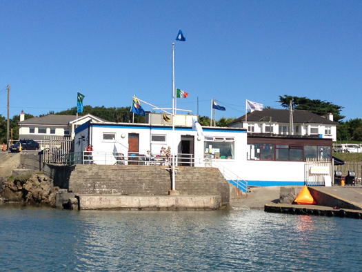
The sunny south. Sutton Dinghy Club is Fingal's most southerly sailing club, and is also rare in Ireland through being south facing.
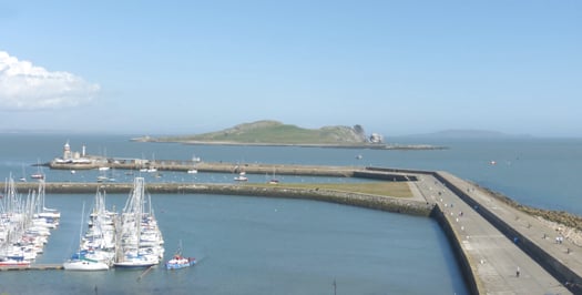
Islands of Fingal seen across the eastern part of Howth marina, with Ireland's Eye in the foreground, and Lambay beyond. Photo: W M Nixon
As for the waters they share, their most immediate neighbour is the steep island of Ireland's Eye with its pleasant southwest-facing beach, the island itself a remarkable wild nesting site, particularly when you remember that it's close beside an intensely urban setting. When a discerning visitor described Ireland's Eye as "an astonishing and perfect miniature St Kilda", he wasn't exaggerating.
Across in Malahide, where we find Fingal's other marina, Malahide YC - which recently celebrated its Golden Jubilee and currently has Graham Smith as its first second-generation Commodore – is in the curious position of having two clubhouses. One is a charming and hospitable place among trees within easy stroll of the marina, while the other is west of the long railway embankment which retains the extensive inner waters of Broadmeadow. This makes the waters into a marvellous recreational amenity and boating and sailing nursery, so not surprisingly it is home to active sailing schools. And it is also the base of Malahide YC "west", a dinghy sailing club on the Broadmeadow shore at Yellow Walls, while further west of it again is yet another club, the more recently formed Swords Sailing & Boating Club.
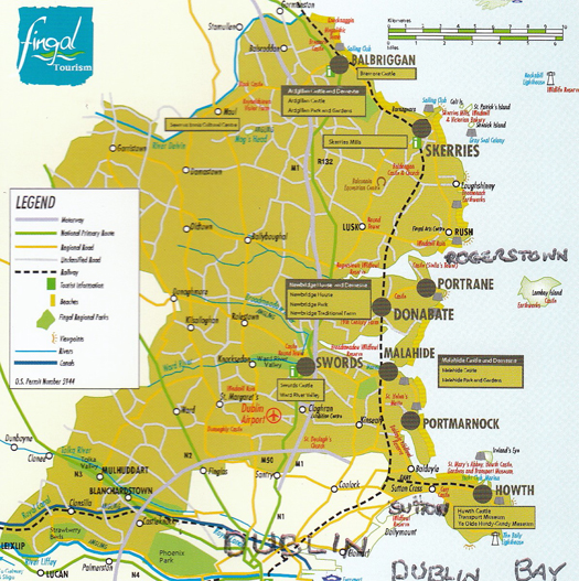
The map of modern Fingal shows how the southwest corner of the present region seems remote from the largely coastal and rural nature of much of the rest of the county. And it also confirms the surprise (to many) that the Phoenix Park is in Fingal.
North from Malahide, and you're into "Fingal profonde", its deeply rural nature occasionally emphasised by the sea nearby. The long Rogerstown Estuary, the next inlet after Malahide, sometimes found itself providing the northern boundary of The Pale, and as recently as the early 1800s the river at Rogerstown and the tiny port of Rush were a veritable nest of smugglers, privateers and occasionally pirates, with buccaneering captains of myth and legend such as Luke Ryan and James Mathews proving to have been real people who were pillars of society when back home in their secretive little communities after their lengthy business forays to God know where.
Muddy situation. Low water in the Rogerstown Estuary. The hill in the distance on the left is new – for years, it was the largest dump in Ireland, the Balleally Landfill. But now it is well on its way to rehabilitation as an enhancement of the landscape. Photo: W M Nixon
The Rogerstown Estuary went through an unpleasant period when its inner waters were dominated by the nearby presence of the biggest waste dump in Dublin, Balleally Landfill. It rose and rose, but now it's closed, and is in process of being revived to some sort of natural state. The result is that the vista westward from Rogerstown is much improved by a pleasant and completely new hill which so enhances the view at sunset that shrewd locals have built themselves a row of fine new houses facing west, along the quirkily named Spout Lane which runs inland from the estuary.
Whatever about the legality-pushing privateer skippers who used Rogerstown Estuary as their base in days of yore, these days it's home to the quay and storehouse which serves the ferry to Lambay, which is Fingal's only inhabited island when there are no bird wardens resident on Rockabill, and it's also the setting for another south-facing club, Rush SC. It is spiritual home these days to the historic 17ft Mermaid Class (they still occasionally build new ones in an old mill nearby), but despite the very strong tidal streams where the estuary narrows as it meets the sea, RSC also has a large cruiser fleet whose moorings are so tide-rode that unless there's a boat on the buoy, it tends to disappear under water in the final urge of the flood. This can make things distinctly interesting for strangers arriving in and hoping to borrow a mooring while avoiding getting fouled in those moorings already submerged. Not surprisingly, with their boat sizes becoming larger like everywhere else, Rush SC find that their bigger cruisers use Malahide Marina.
To seaward of Rogerstown, with the little port of Rush just round the corner, the view is dominated by Lambay. A fine big island with is own little "miniature Dun Laoghaire" to provide a harbour on its west side, it has a notable Lutyens house set among the trees. But for many years now Lambay has been a major Nature Reserve, so landing is banned, though anchorage is available in its three or four bays provided you don't interfere with the wildlife along the shore. This makes it off bounds to kayakers who might hope for a leg stretch on land, though it's still well worth paddling round close inshore.
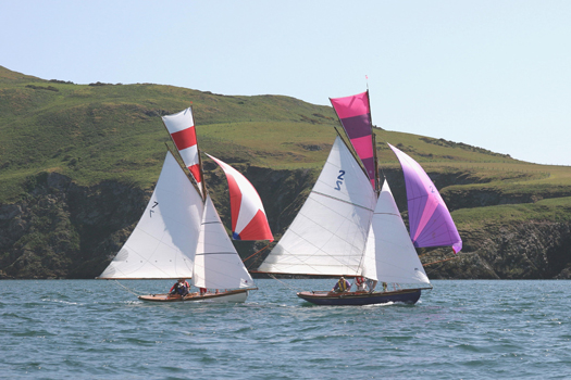
Racing round Lambay. Close competition between the Howth 17s Aura (left) and Pauline, which have been racing annually round Lambay since 1904. Photo: John Deane
Along the Fingal mainland coast, the next inlet after Rush is Loughshinny, a lovely natural harbour with a quay to further improve the bay's shelter. There's a very active little fishing fleet, while the shoreside architecture is, how shall we say, decidedly eclectic and individualistic? Go there and you'll see what I mean.
Six miles offshore, Rockabill marks the northeast limits of Fingal. It's a fine big double-rock, with a substantial lighthouse and characterful keepers' houses attached. But as it's now automated, the only time Rockabill is inhabited is for the four summer months when a bird warden or two take up residence to monitor the rocky island's most distinguished summer residents, Europe's largest breeding colony of roseate terns.
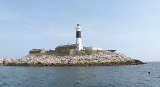
Rockabill, where the shy roseate terns feel at home. Photo: W M Nixon
In Fingal we tend to take these pretty but noisy summer visitors for granted, but the word is that south of Dublin Bay the tern buffs are so incensed by Rockabill having a clear run that they're tried to start a rival colony of roseate terns on the Muglins, and built a row of tern houses (one good tern deserves another) to facilitate their residence. The potential nest sites may not have survived the past severe winter. But in any case, one wonders if they had planning permission from Dun Laoghaire/Rathdown council for this development? Persons suggesting that such a development would almost certainly be terned down will not be given any attention whatsoever.
Skerries and Balbriggan are the two main sea towns of north Fingal, and they're as different as can be, the difference being emphasised by historic rivalry. It's said that back in the government harbour-building days of the late 19th Century a grant was made available to assist local landowners to make significant improvements to one of the harbours, and this meant war.
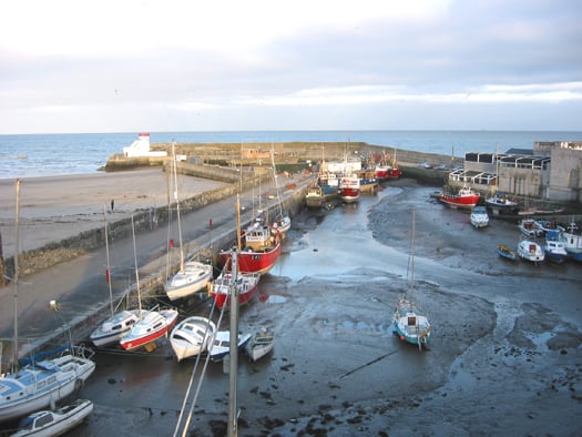
Balbriggan may very definitely dry out, but it provides a secure home port for both trawlers and other boats prepared to settle on the mud and sand. Photo: W M Nixon
So eventually the grant was split with half going to improve Balbriggan, and the other half to Skerries, with neither being a total success. If you seek total shelter in either today, you have to be prepared to dry out, while the anchorage off Skerries is also subject to a large tidal whorl which means that when the ebb is running in a strong onshore wind, the moorings are doubly rough and diabolically uncomfortable. And every so often after an exceptional nor'easter, we have another litany of boats driven ashore and Skerries yacht insurance going even further through the roof.
It's a situation which needs proper attention from an administration which is genuinely interested in the port. And the proper development of the harbour at Skerries, while retaining the little old place's special character, is surely something which could be much better done by Fingal Council rather than some remote Mayor of Dublin for whom Skerries will be the outermost periphery, a place seldom visited, if at all.
We've seen it all before. Time was when Fingal was simply the North County, little noticed in the centres of power which were basically Dublin City and Dublin County, their head offices in the heart of the city. But then in 2001 the new four-council setup was created, and the old name of Fingal – never forgotten by those who cherished the area – was revived. A very fine new user-friendly County Hall – it has even been praised by Frank McDonald of The Irish Times – was built in the re-born county town of Swords. Out on the new boundaries meanwhile, the signs went up saying "Welcome to Fingal County". But we old Fingallion fogeys pointed out that as Fingal means "Territory of the Fair Strangers" (i.e the Norsemen rather than the Danes), it was superfluous to be describing it as "the county of the territory", so these days it's just Fingal, and we're happy with that.
Here in Howth, we sort of slipped into acceptance of the new setup. Once upon a time, from 1917 to 1943, Howth had its own Urban District Council. It says much for the place's remoteness from the world that the HUDC was established in the midst of one global war, and quietly wound up in the midst of another. In 1943, Commissioners had to be imposed on the tiny fiefdom to offset the fact that some local interests thought the HUDC existed entirely for their own personal benefit. So at various times since, Howth was run either by Dublin County Council, or even by Dublin City Corporation. We were assured that this latter setup was all to our benefit, as the powers-that-be in City Hall had a soft spot for Howth, sure wasn't it the place where the mammy went every Thursday evening to buy the family's fish, and wouldn't she want to see it looking well?
Maybe so, but when it came to doing something more useful with the harbour, Howth Yacht Club – having re-constituted itself in 1968 from an amalgamation of Howth Sailing Club (founded 1895) and Howth Motor Yacht Club (founded 1934) - found itself dealing with a bewildering variety of government departments as the lowly interests of fishing and its ports seemed to be shifted whenever possible by civil servants who reckoned that banging the drum on behalf of fisheries in particular, and maritime interests in general, was not a shrewd career move for anyone planning a steady progress up the very landbound Irish public service ladder to the sunlit uplands of a long and prosperous retirement.
So if at times absolutely nothing seemed to be happening in a harbour which was painfully inadequate for expanding boating and fishing needs, it was partly because the club officers and fishermen's leaders could find it difficult to discern just who in authority could or would make the decisive call. In those days it turned out to be somewhere in the hidden recesses of the Office of Public Works. Suddenly, in 1979, a plan for the major re-development of the harbour was promulgated at official level, with a radical rationalisation planned for its future use. The western part, it was proposed, would become totally fisheries, while the eastern part was to be given over to recreational boating, all of it involving major civil engineering and harbour works projects.
Looking at the successful harbour today, it all seems perfectly reasonable and sensible. But back in 1979 when HYC were presented with a time-limited take-it-or-leave-it choice, the way ahead was not at all clear. Friendships were sundered and family feuds emerged from the heated progress towards accepting the offer that the club agree to vacate its premises on the West Pier - a clubhouse which it had renovated and extended only ten years earlier – and commit itself to the installation, at members' cost, of a marina in the eastern harbour with the obligation to build a completely new clubhouse there.
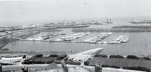
Today's Howth Harbour didn't happen overnight. This is how it was from 1982 until the new clubhouse was completed in 1987. Photo: W M Nixon
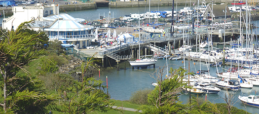
Multiple activities under way at Howth YC this week. The club's setup may seem only natural now, but it was quite a struggle to get there. Photo: W M Nixon
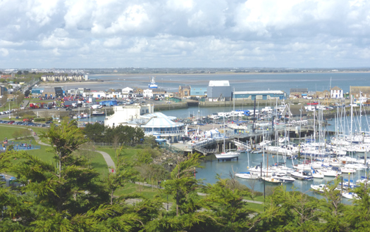
Howth's vibrant mix of a working fishing port and busy sailing centre has provided the ideal setting for the development of a successful visitor and seafood destination. Photo: W M Nixon
It's all history now, but it was done. And done so well by those involved that today it's simply taken for granted. Arguably, it's a compliment to those who created the Howth YC setup, that newer members should seldom wonder how it all came to happen, it just seems so right and natural. And as for those running the club, they in turn have to build on past achievements in dealing with an ever-changing administrative environment in which the changeover to being part of Fingal was only one of several evolutions.
Yet the recent attempt to abolish Fingal was a wake-up call. In Howth we may have wandered into it, but in just a dozen years, a dormant Fingal identity has come quietly but strongly awake. In Howth village it's natural enough, as our backs are turned to Dublin and we look to the rest of Fingal. But even on the south side of the hill, where fine houses face across Dublin Bay and you'd expect a sense of identity with households in similarly choice locations for all that they look north out of Dun Laoghaire, you find that the attraction of visiting the southside has the exotic appeal of going foreign, while those of us more humbly placed in the village, if visiting remote places like Rathmines or Terenure, find it positively unnerving to think of all the houses between us and the sea.
Then too, while Fingal Council has been establishing itself in our hearts and minds, it has been a good time for Howth Harbour. Good fences have been making good neighbours, and though marine administration in government has been kicked from pillar to post, an underlying Department of Fisheries recognition that their harbours cannot be only about fishing has led to a re-think on the use of buildings about the harbour, with Howth becoming an extraordinary nexus of good seafood restaurants, such that on a summer evening, despite the presence of a traditional fish and chip shop, the seafood aroma is of a proper fishing port in Brittany or Galicia. In fact, rents from the hospitality and sailing and marine industries in Howth have now reached such a level that fish landing fees – formerly the bedrock of the harbour economy – only contribute about 10% of the overall income.
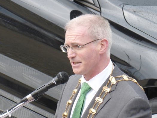
The man from County Hall. Fingal Mayor Kieran Dennison is comfortable with his county's busy sailing activities, and the sailors are comfortable with him. He is seen here officially opening the J/24 Worlds at Howth in August 2013. Photo: W M Nixon
As for how we've been getting on with our new masters in County Hall up in Swords, the news is good. Most recently, we've been having direct contact with the current Mayor of Fingal, Kieran Dennison, who hit just the right note when he officially opened the J/24 Worlds in Howth in August 2013. Following that, he was back at the annual Commodore's Lunch in HYC in the dark days of November when a review of the past season lightens the onset of winter, and he was able to tell us that thanks to contacts made at the Worlds, his invitation to visit the America's Cup in San Francisco in September was made even more enjoyable. Those of us who reckoned the only way to visit the 34th America's Cup was on the television screen were reassured by the thought that if somebody was going to represent us in the San Francisco bear-pit, then our Mayor, our very own Mayor of Fingal, was just the man for the job.
So we very much want to keep Fingal in existence and in robust good health, but we appreciate that its current boundaries might be creating a bit of a Ukraine-versus-Russia situation. In particular, the southwest of the county could well be Fingal's Crimea and Donetsk regions. There, relatively new settlements of ethnic Dubs in places like Clonsilla, Castleknock, Blanchardstown could become such a source of trouble that it might be better to transfer them peacefully to administration by either Dublin city or South Dublin before there is unnecessary bloodshed.
The situation arises because, when the boundaries were being drawn, southwest Fingal was set out all the way down to the Liffey. The Fingallion instinct would be to see the border drawn along the Tolka, in other words the M3. But there could be trouble because of the discovery – always something of a surprise – that the Phoenix Park is in Fingal. I could see that when some people find our Fingal includes the Park, they'll want to fight for it, particularly as, in the southeast of the county, the excellent St Anne's Park in Raheny was somehow allowed to slip into Dublin City.
One thing which is definitely not for transfer is the Airport. It is naturally, utterly and totally part of Fingal. For sure, it contributes a fifth of the county's annual income from business rates, making Fingal the economically healthiest Irish county. But we in Fingal have to live with the airport very much in our midst. If Dublin really wants to take over the airport, then a first condition before negotiations even begin would be that all flight paths are to be re-routed directly over Dun Laoghaire and Dalkey. A few weeks of that would soon soften their cough.
Whatever, the recent kerfuffle about Fingal rejecting involvement in administration by an all-powerful Mayor of Dublin has been a powerful stimulant to thinking about how our own county might best be run. Everyone will have their own pet local projects, and most of us will reckon that decision-making in Swords, rather than in some vast and impenetrable office in the middle of Dublin, will be the best way to bring it about. For those of us who go afloat, the fact that Fingal Council shows that it cherishes its long and varied sea coast, rather than preferring to ignore it, is very encouraging. And the fact that this prospering county has some financial muscle all of its own gives us hope that we can build on what the past has taught us, and spread improved facilities to every port. Should that happen, it will in turn benefit Irish sailing and boating generally to a greater extent than would restricted development under one closely-controlled central administration headed by some southside megalomaniac.
Skerries Lifeboat Rescues 3 From Grounded Fishing Vessel
#RNLI - Skerries RNLI rescued three men last night (Thursday 24 April) after their 30-foot fishing vessel ran aground on rocks north of Balbriggan harbour in extremely poor visibility.
The volunteer crew launched their inshore lifeboat shortly after 9pm with Rob Morgan as helm and crew members Emma Wilson, Stephen Crowley and Laura Boylan also on board.
The Dublin Coast Guard requested the lifeboat to launch after receiving of reports that a vessel had struck rocks north of Balbriggan harbour. The lifeboat proceeded directly to the area indicated.
Conditions on the night were calm with a force one southerly wind, though there was a thick sea fog in the area at the time and visibility was reduced to 1-2 metres.
Clogherhead RNLI's all-weather lifeboat also launched at 10pm after Skerries RNLI requested their assistance, given the possibility that a long and difficult search may have been necessary. Coastguard helicopter Rescue 116 and the Skerries coastguard ground unit were also tasked.
Communication with the vessel in distress was established through another fishing vessel. Along with the information relayed from the vessel, the volunteer crew used the radar and direction finder on board their Atlantic 85 inshore lifeboat to pinpoint the casualties location.
The three men were taken on board the lifeboat where they were assessed and did not require any medical attention.
Clogherhead RNLI, Skerries coastguard and Rescue 116 were all stood down as Skerries RNLI returned the three men to the lifeboat station, where they were reunited with waiting family members.
Speaking after the call-out, Skerries RNLI helm Rob Morgan said: "Visibility was extremely poor out there this evening. The volunteers training really paid off, particularly with the radar and VHF direction-finding equipment. Thankfully we found them in time and it was a good result."
'Safety Sunday' With Lifeboat Launches In Wicklow And Skerries

#RNLI - Wicklow RNLI went to the assistance of three fishermen whose 36ft fishing boat suffered engine failure near Wicklow Head yesterday afternoon (Sunday 24 November).
The alarm was raised after the crew were unable to start the engine and were concerned about the possibility of their boat being swept ashore.
The Wicklow RNLI all-weather lifeboat launched at 2.30pm under the command of coxswain Ciaran Doyle, followed a few minutes later by the inshore lifeboat.
The drifting fishing vessel was located 10 minutes later about half a mile east of Brides Head. Weather conditions at the time had the wind at a northerly Force 3, with a slight sea state and good visibility.
A towline was quickly established and the stricken vessel was towed back to Wicklow by the lifeboat before 3pm with no further incident.
Much earlier in the day, the Skerries RNLI volunteer crew were tasked to investigate reports of a person in the water in Balbriggan Harbour in the small hours of the morning.
The crew were paged at 12:30am and the lifeboat was launched shortly after with helms Joe May, Conor Walsh and David Knight and crew member Peter Kennedy on board.
There was a Force 3 to 4 northwesterly wind blowing at the time and the sea state was moderate.
The lifeboat proceeded directly to Balbriggan Harbour where it was quickly determined that the person had been taken from the water and was receiving first aid treatment by members of Dublin Fire Brigade and the HSE ambulance service.
The lifeboat then proceeded to carry out a thorough search of the harbour to ensure that there was nobody else in the water before returning to station.
Speaking afterwards, helm Joe May said: "Our volunteer crew are on call 24 hours a day, 365 days of the year. The pager can go off at any time but we are always ready to respond."
Skerries Lifeboat Joins Flare Search Off Gormanston

#RNLI - Skerries RNLI joined Clogherhead RNLI and Irish Coast Guard helicopter Rescue 116 in a search off Gormanston on Tuesday night (10 September) after reported sightings of distress flares in the area.
The volunteer crew launched their newly dedicated inshore lifeboat Louis Simson shortly after 8.30pm with Conor Walsh as helm and crew members Peter Kennedy, Stephen Crowley and Laura Boylan also on board.
Dublin Coast Guard requested the lifeboat to launch after receiving a number of reports of distress flares in the vicinity of the Gormanston area. Clogherhead RNLI and Rescue 116 were also tasked, with the former being assigned the role of on-scene coordinator for the search. Conditions on the night were calm with a force 1 to 2 North by North West wind.
Working together, the two lifeboats and the helicopter conducted an extensive search of the area. Just after 9.30pm, Dublin Coast Guard declared that they were satisfied the area had been searched thoroughly ,and with nothing found all units were stood down to return to base.
Speaking after the call-out, Skerries helm Walsh said: "Working together with Clogherhead lifeboat and the coastguard helicopter we were able to cover a large search area quickly.
"Distress flares are an important piece of safety equipment and are a very effective way of calling for help. Thankfully on this occasion no lives were in danger."
This is the second time in less than a month that Skerries RNLI responded to reports of distress flares, after launching to similar reports of flares north of Balbriggan on 14 August.
New Skerries Lifeboat Dedicated In Special Ceremony

#RNLI - Skerries RNLI officially named its new Atlantic 85 lifeboat Louis Simson at a special ceremony held today (Saturday 7 September), as reported yesterday on Afloat.ie.
David Delamer, a member of the Irish Council of the RNLI, accepted the lifeboat and her launching carriage on behalf of the RNLI before handing her over into the care of Skerries Lifeboat Station.
He paid tribute to the donor, Charlotte Simson, who had generously funded the lifeboat through a gift left in her will. The legacy was 75 years old.
Simson, who hailed from Salem in India, funded the lifeboat which has been on service in Skerries since February, in memory of her husband Louis, from London.
"Mrs Simson made provision in her will for a trust fund that would provide various relatives with a modest income for life," Delamer explained. "She arranged that once the trust fund had come to an end, the remaining money should fund an RNLI lifeboat to be named in memory of her beloved husband. Now three quarters of a century on, Mrs Simson’s wish will be granted."
Leo Cody, a founding member of the Skerries RNLI inshore lifeboat station and a former deputy launching authority, then officially named the lifeboat during the ceremony.
The new state-of-the-art Atlantic 85 lifeboat was introduced into the RNLI fleet in 2005. The lifeboat is 8.4 metres in length and weighs 1.8 tonnes. Improvements on its predecessor include a faster top speed of 35 knots, radar, provision for a fourth crew member and more space for survivors.
Since the new lifeboat went on service in Skerries, there have been 24 call-outs and 49 people have been brought to safety.
Niall McGrotty, Skerries RNLI lifeboat operations manager, said the naming ceremony and service of dedication was a special occasion in the history of the Skerries lifeboat station, adding that the volunteer crew was grateful to Simson for her generous legacy which had funded the lifeboat.
He added that the RNLI could not operate its lifeboats without the dedication of volunteer lifeboat crew.
"The crew in Skerries give 100% at all times. Their commitment and ongoing attendance for training both here and at the lifeboat college means that they are highly proficient in the operation of their lifeboat.
"Further testament of the dedication of the crew is their knowledge that they may risk their own lives in the service of others. There is nothing greater that a person could offer and they deserve nothing less than the best lifeboat, equipment and training that money can buy."
McGrotty went on to pay tribute to the vital support provided by the volunteers who support the crew.
"The lifeboat crew and I are only one part of this station. I must mention our operation team, supporters and fundraisers who volunteer their time and efforts and do so much for Skerries RNLI. These are people of all ages who give what time and money they can."
A crowd of well-wishers turned up to see the lifeboat officially named, with a bottle of champagne poured over the side of the boat before it launched at the end of the ceremony.
Among the guests were Des Frazer, president of the Skerries RNLI Lifeboat Management Group, who welcomed guests and opened proceedings; Leo Cody, who back in 1967 was appointed the honorary secretary of the Skerries fundraising branch and is a former deputy launching authority; and Brian Carty, a former crew member, deputy launching authority and chairman, who delivered the vote of thanks.
Father Richard Hyland, Reverend Anthony Kelly and Reverend David Nixon lead the Service of Dedication.
Diver Stung In Face By Jellyfish Off Skerries
#Jellyfish - In less welcome jellyfish news, the Irish Independent reports that a female diver was airlifted to hospital after being stung in the face by a jellyfish off Skerries at the weekend.
The injured woman had been diving yesterday morning (1 September) in shallow waters off the North Co Dublin town with a party of five, three of whom raised the alarm when they lost sight of the other two.
Skerries RNLI were requested to launch by the Dublin Coast Guard, and after a short time searching they located the missing divers on the shore at a local swimming spot called the Springers.
The lifeboat crew found one of the women was in need of urgent medical assistance, suffering from severe hypothermia and jellyfish stings to the face.
Medical transfer to Our Lady of Lourdes Hospital in Drogheda was decided as the best option, and the casualty was soon airlifted from nearby Red Island on board the Irish Coast Guard helicopter Rescue 116.
Speaking after the call-out, Skerries RNLI volunteer lifeboat press officer Gerry Canning said: "This was a perfect example of how well our volunteers and all the other emergency services work together to ensure that casualties get the best possible care and in the quickest possible time."
Skerries RNLI Launches To Flare Sighting Off Balbriggan

#RNLI - Skerries RNLI carried out a search of an area north of Balbriggan on Wednesday night (14 August) after a vessel in the area reported sighting a distress flare.
The volunteer crew launched their inshore lifeboat shortly after 9.30pm with Philip Ferguson as helm and crew members Adam Scott, Stephen Crowley and AJ Hughes on board.
Dublin Coast Guard requested the lifeboat to launch to investigate a report of a distress flare north of Balbriggan Harbour in North Co Dublin.
The lifeboat proceeded directly to the area indicated by the coastguard and conducted an extensive search. Clogherhead RNLI were also tasked and carried out a search further north, while the Skerries Coast Guard unit carried out a search of the coastline in the area.
Just after 10.30pm, the Dublin Coast Guard declared that they were satisfied that a thorough search had been carried out, and with nothing found all units were stood down to return to base.
Speaking after the call-out, Philip Ferguson said: "Conditions were very good on scene and while it was quite a dark night, visibility was reasonably good which helped our search.
"Our volunteer crew are always ready to launch to any sign that somebody is in difficulty at sea and we are happy that on this occasion no lives were in danger."
Skerries Oil Spill Prompts Beach Closure
#OilSpill - An oil spill at Skerries Harbour in North Co Dublin has prompted the closure of Skerries North Beach as a precaution.
RTÉ News reports that the spill is a minor incident, and that Fingal County Council is monitoring the situation in Skerries and area beaches.
Skerries North Beach, while popular with locals, is not among the designated bathing areas listed by region by Irish Water Safety HERE.
Skerries Lifeboat Rescues Colt Island Kayakers

#RNLI - Skerries RNLI rescued a group of teenagers who got into difficulty while kayaking on Sunday evening (30 June).
The volunteer crew launched their inshore lifeboat shortly after 6pm to reports of a group of kayakers on Colt Island who were unable to return to shore due to the deteriorating weather conditions.
Skerries RNLI lifeboat operations manager Niall McGrotty paged the crew after receiving information from a retired crew member that there was a group of kayakers stranded on Colt Island.
The lifeboat was helmed by Joe May and had crew members Philip Ferguson, David Knight and Adam Scott on board. Weather conditions at the time were a force five to six northerly wind and choppy seas.
Arriving on scene three minutes after launching, the lifeboat found 11 teenage boys with five kayaks sheltering on Colt Island, as they were unable to return to shore against the increasing wind and waves.
All 11 boys were taken on board the lifeboat and the five kayaks were taken in tow. The lifeboat towed the kayaks back to the slipway at the station where the volunteer shore crew recovered them. The lifeboat then brought the teenagers safely back to the harbour.
Speaking after the call-out, Skerries RNLI helm Joe May said: "The boys did the right thing in staying together, staying on the island and raising the alarm. If they had tried to make it back to shore we could have been dealing with a much more serious situation.
"Our volunteer crew are always ready to respond to any emergency and we were happy to bring everyone safely home."
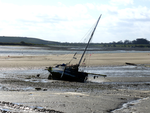
Skerries RNLI Assists Lone Sailor On Grounded Yacht

#RNLI - Skerries RNLI launched shortly before 7pm yesterday evening (Thursday 27 June) to assist an 11m yacht with one person on board that had run aground north of Rush Harbour.
The Dublin branch of the Irish Coast Guard requested Skerries RNLI to launch after two members of the public, who had been out kayaking, reported that the yacht was in difficulty.
Weather conditions at the time were a force one to two wind with calm seas.
The lifeboat, helmed by Willie Boylan with crew members Conor Walsh, Karl Duff and Peter Kennedy on board, was on scene in less than 10 minutes. However, by that time the yacht was completely aground above the tide line.
Two volunteer crew members were put ashore to assess the casualty vessel. There was only one person on board and he was not in any immediate danger. There also appeared to be no significant damage to the hull of the boat.
The crew members laid out an anchor from the vessel to ensure that it did not drift onto the nearby rocks when it began to float again. Irish Coast Guard helicopter Rescue 116 was also on scene briefly to ensure that no assistance was required.
With the tide still falling, the decision was taken for the lifeboat to return later after the tide had turned to ensure that the yacht floated safely and to assist in helping it safely back to a harbour.
At 10.20pm the volunteer crew launched the lifeboat again to attend to the yacht, this time with Conor Walsh at the helm and Karl Duff, Eoin Grimes and Emma Wilson as crew, bringing a salvage pump with them.
One of the crew was put ashore to check on the casualty again and to secure a tow line to the boat. As the tide rose, the lifeboat kept the tension on the tow to prevent the yacht being pushed further on to the rocks.
At 11.45pm the yacht was refloated and guided back to Skerries Harbour with the lifeboat leading the way to help navigate around the islands safely in the dark.
Speaking after, Skerries RNLI lifeboat operations manager Niall McGrotty said: "There didn’t appear to be much damage and the conditions were calm. However, it was a large boat with a lot of equipment on board, so there were some concerns around whether it would refloat successfully. Thankfully, it did and everyone made it home safe and sound."


, and Dermot O’Kane, Head of Sales, Esri Ireland. Esri Ireland is announcing that its digital mapping system is helping DURL to prevent 13 million litres of polluted wastewater from entering Dublin rivers annually, by locating misconnected household appliances that are expelling polluted water")


 Michael Murphy Schull Harbour Sailing Club (SHSC), Eric Coogan Heineken Ireland, Mark Murphy, Commodore SHSC, Jack Allen SHSC, Carmel O'Regan SHSC, Cornelious Ndlovu, Schull Harbour Hotel Operations Manager and Derval Murphy SHSC")


