


Displaying items by tag: This island nation
Preserving The Naomh Éanna, GPS Failure, & Buying An Island?

#IslandNation - Readers of this blog have been kind in welcoming me back to the airwaves, for which I am grateful. Community radio on which I now broadcast is quite a big operation about which I did not know a lot until I met the people who run Community Radio Youghal, CRY104FM, in the seaside town on the East Coast of County Cork. At their invitation I returned to the airwaves, broadcasting THIS ISLAND NATION every month and with more development now ahead, thanks to the positive response of listeners.
Every week 2,000 radio volunteers around the country engage with 307,000 listeners, broadcasting from 22 fully licensed stations, in addition to which there are a number of stations at different stages of development. Community radio is a rapidly growing broadcasting sector and a force for community development, identity and expression.
A community radio station is not focussed solely on broadcast schedules, which are subject to the diktats of commercial interests for advertising purpose. So it has a stronger focus on the values and interests of the community to which it broadcasts and can provide a wider variety of broadcasting. It appears to me that it can offer what is missing from mainstream media, newspapers, radio and television - and that is a regular forum for maritime news, information, comment and opinion, related directly to communities. The mainstream media, with a few exceptions, does not give sufficient regular, informed, balanced coverage of the marine sphere.
Transmission of THIS ISLAND NATION as a monthly radio programme about the sea, with the well-known signature tune ‘Sailing By', began earlier this year and interest has grown. ‘Sailing By’ was dropped by RTE as the signature tune for the programme Seascapes, which I had developed and broadcast there for over 20 years.
NEAR FM 90.3 community radio for Dublin North East and Raidió Corca Baiscinn 94.8 FM in County Clare also broadcast THIS ISLAND NATION, as does Afloat.ie on this website. I am hopeful that more community stations around the country will join in broadcasting the programme, for which the plan now, in response to growing interest, is to increase transmission from monthly to fortnightly from next month. CRAOL is the national representative body for the community radio movement.
With modern technology it is quite easy to listen to radio stations broadcasting from anywhere around the country. The app Tune In Radio, which can be downloaded from the Google Play store, is great for listening to radio anywhere. Download it and you have access to all radio stations on Adroid smartphones, tablets, laptops and desktops. That includes, of course, those which broadcast THIS ISLAND NATION.
PRESERVING THE NAOMH ÉANNA
After what has been a long battle against what seemed to be the complete disinterest of Government and State agencies in maritime heritage, Sam Field Corbett tells me that his Irish Ship & Barge Fabrication Company has acquired the heritage ship Naomh Éanna – “effectively securing the vessel for the next three months,” he says. “During this period IS&BF will complete the in-depth survey required to calculate the cost of repairing the hull and machinery to compliment the calculations for her refit as a boutique hostel, restaurant, cafe and museum.”
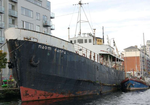
The Naomh Éanna was built by the Liffey Dockyard and launched in the late 1950s. Until 1988, it served as the Galway-Aran Islands ferry and had been operated by CIE. The vessel was purchased by the Irish Nautical Trust and moored at Grand Canal Dock in 1989 after it was decided that it could no longer operate as a passenger-carrying vessel.
Waterways Ireland, owners of the Grand Canal Dock, had determined to scrap the ship, maintaining that its condition was unsafe. WI had little interest in listening to proposals for preserving the ship. There was a debate about it in the Dáil which was told that the underwater archaeological unit of the Department of the Environment did not consider that the Naomh Éanna should be protected and disregarded the fact that it was “an example of the shipbuilding techniques used in the Liffey Docks in the 1950s”. That type of history, according to the Department, did not “justify the expense that would be involved in its preservation”.
Closed minds towards maritime heritage continue to dominate official circles but Sam Corbett refused to give up. Those supporting him had to fight against the attitude of officialdom which sought to exclude several of those who could be considered ‘stakeholders’ from meetings about the future of the ship, according to those who had an open mind the future of the vessel.
Sam Corbett tells me that “the final part of the negotiations” lies with NAMA “who seem close to issuing the three-month lease on the site which will allow surveyors to access the ship and determine her condition.
“Difficulties regarding a €50,000 bond in favour of Waterways Ireland should they be expected to step in and remove (scrap) the ship should IS&BF efforts to secure funding fail, may be close to being resolved. IS&BF presented Nama with an undertaking by a recycling company experienced in specialist breaking and NAMA are considering this option. We hope to have a decision shortly.
"IS&BF are intent on approaching a number of venture capitalists to invest in the project which is presented as a viable business. How the business plan is received by potential investors will ultimately decide the ship’s fate. We have chosen to approach potential investors who have an interest in supporting Irish heritage and jobs.
“This was the original proposition since we became aware the ship was going to be scrapped many months ago. It has been a long process. Without support it would not have been possible. Indeed, it would have surely been scrapped if it had not been for the direct intervention of TDs Kevin Humphreys, Sean Kyne, Joan Collins, Eamonn O Cuiv, Senator David Norris and Councillors Mary Freehill and Dermot Lacey among others.
"Many challenges lie ahead. However, it’s a great accomplishment to have got this far. The money donated by our supporters will be used to conduct the survey as planned and the reimbursement of this money to the RNLI has been included in the project costings. We hope to be able to invite all our supporters to visit the ship when she is being restored and look forward to meeting everyone then.”
Sam Corbett Field is the man who led the restoration of the former Cork Harbour liner tender MV Cill Áirne which could also have been destined for destruction but is now a floating restaurant on the Liffey in the Dublin Docklands near the IFSC. He is also involved in the operation of barges like the Riasc on the Dublin canals. He is not a man who gives up!
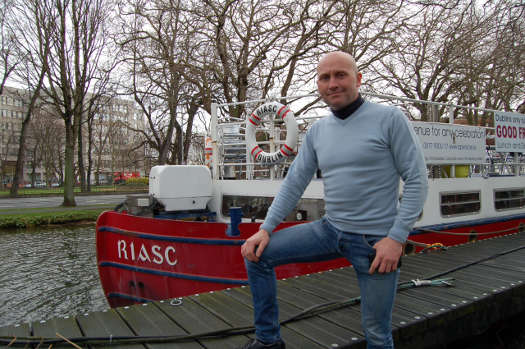
Sam Corbett Field by the Riasc on the Grand Canal
GPS FAILURE
It did not get a lot of public media attention at the time, though it was well-known in maritime circles, when the satellites in the Russian GLONASS GPS system failed for 11 hours last April. It was an unprecedented total disruption of a fully-operational satellite positioning service. As a result, the Russian GPS system was completely unusable to all worldwide GLONASS receivers.
The extent of the disruption has become clear following information released by the General Lighthouse Authorities of the UK and Ireland. GLA readings from their GLONASS receiver in Harwich showed location errors of over 30 nautical miles off the UK coastline.

Apparently the problem occurred because of what were described as “bad ephemerides” being uploaded to satellites. Navigation messages from every satellite requires ephemeris data which is used by the satellite to check its orbital position and information about the time and status of the entire constellation. This data is then processed by user/receivers on the ground to compute their precise position. Less than a fortnight after the first failure, a second malfunction occurred temporarily knocking-out nine GLONASS satellites.
There are, according to information, quite a lot of GLONASS users, including some mobile phone systems. The GLA said that what happened “is a timely reminder that alternatives to satellite navigation are essential”.
The GLA themselves are supporting eLoran as an alternative to GPS for the UK and Ireland. This system transmits long-range position, navigation and timing signals from a ground-based radio network. Its primary use is for ships and others in the maritime sector, but it could provide a back-up for GPS, GLONASS and GALILEO (the long-awaited European system) when it arrives. But eLoran is still proving a hard sell to gain acceptance, according to those in the business.
A Royal Academy of Engineering report in 2011 declared that the UK was becoming dangerously over-reliant on Global Navigation Satellite Systems. Use of space-borne positioning and timing data is now widespread, in everything from freight movement to synchronisation of computer networks. The academy found that “too few of these applications have alternatives should the primary sat-nav signals go down”.
There is a detailed article about the failure of the GLONASS system and the implications for GPS in the September edition of Seaways, the international journal of The Nautical Institute.
BUYING AN ISLAND
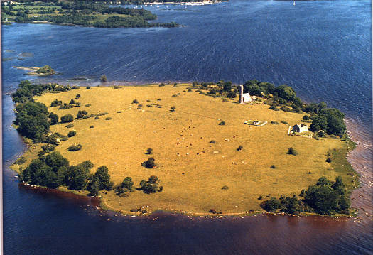
There are a lot of interesting things happening along the Shannon, the latest of which is the decision of Clare County Council to buy Holy Island on Lough Derg, which is the largest lake on the River Shannon. The island has links back to Brian Boru. Called also the 'Jewel of the Lough', it is an important historical and ecclesiastical site, covering 50 acres of which four are in the ownership of the Office of Public Works. There are monastic ruins, including a 24m-high round tower, an oratory and church buildings. The island is still used as a burial ground. It is not far from the village of Mountshannon.
DRIFT NETS ABOLITION
The European Fisheries Commission wants to prohibit the use of any kind of drift nets for fishing in all EU waters from January of next year. It would also be made illegal to keep drift nets aboard fishing vessels. It is an all-embracing ban, typical of EU bureaucracy which does not give sufficient consideration before action to the socio-economic effects on, for example, coastal fishing communities, against whom its effects could be discriminatory.
While a ban on the abuse of these nets by big fishing boats from major fishing nations has had some positive effects on salmon stocks and protection of marine mammals, the EU and Irish Governments are ignoring the need, which is clear, for a comprehensive, long-term plan to be devised, with the involvement of local people, for the future of sustainable coastal fishing communities.
As an example of the disregard for coastal communities, the Government has still not responded to the Report of the Oireachtas Committee on Fisheries published last December that called for a Dáil debate and specific attention to be given by Government Departments to the socio-economic problems of Ireland’s coastal and island communities.
WHAT HAPPENS TO A SHIP?
Rarely does the general media report afterwards what happened to a ship aboard which a disaster has occurred. One such vessel was the MV MSC Flaminia, a German-owned container ship which caught fire on 14 July 2012, forcing the crew to abandon ship in the middle of the Atlantic Ocean. Three seafarers were killed.
Due to the damage and the cargo she was carrying, no country would give her ‘safe haven’ after the fire was put out. Eventually, nearly two months later, the German government had to respond to the requests of salvage crews and allowed the damaged vessel to be towed into Wilhelmshaven in Germany on 9 September.
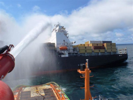
The MV MSC Flaminia on fire in the mid Atlantic
In March 2013 she departed Wilhelmshaven for the Daewoo shipyard at Mangalia in Romania, where repairs were carried out. They were completed this July and the Flaminia, a post-Panamax container ship with a capacity of 6,750 TEUs and deadweight tonnage of 85,823 tons, 980 feet long and 130 feet wide, drawing 48 feet when fully laden, has returned to service. The repair work on the badly-damaged vessel included conversion into a modern eco-ship to reduce fuel consumption.
Email: [email protected]
Twitter: @TomMacSweeney
#islandnation – Entering Kinsale Harbour, east of the Bulman Buoy, is a prominent 200-foot cliff rising sharply above the sea. It is known as Hangman Point and was the location of a gibbet, a warning to everyone not to engage in piracy. Displayed there in 1675 was the head of one of six Irishmen who had murdered the Master and three crew aboard what was described as "a very rich ship," the St.Peter of Hamburg which had been bound for France. This gang sailed the vessel to the West Coast of Ireland where they were captured by the authorities led by Robert Southwell, Vice Admiral of Munster. Convicted and executed, their heads were displayed at different points along the coast, including one at Hangman Point.
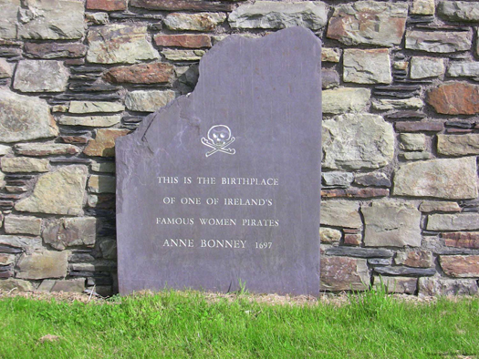
The next time I am rounding the Bulman heading for Kinsale I'll take more note of Hangman Point about which I hadn't known a lot, though I did know of the roadside reminder out towards the Old Head of Kinsale of the female pirate Anne Bonney, another story of piracy from the locality. She was actually Anne Cormac, described as "a vivacious girl" who lived with her father, William, in a fine house on the edge of Bullen's Bay which was a haven for piracy on the south coast not far from Kinsale, providing a place to land stolen goods and get water and provisions.
She shared the maritime activities of the area, but her father was actually a successful Cork lawyer who emigrated from that area to the Carolinas in America where the doughty daughter was drawn to the sea, despite the best efforts of her father to steer her in other directions. This led her to falling for the charms of pirate and buccaneer 'Calico' Jack Rackham who was terrorising the coast of Bermuda.
Anne took to the life of piracy, engaged in it by boarding ships and capturing and looting them and was regarded as a tough fighter. Despite pregnancies, she had her children fostered to continue her cutlass-bearing life. Captured eventually, both 'Calico' and Anne were sentenced to hang. Because she was again pregnant she was reprieved and her last words to 'Calico' before he faced the hangman, according to legend were: "If you had fought like a man, you would not now be hanged like a dog!"
I am not sure I would particularly like such a female type aboard, but out towards the Old Head of Kinsale there is a roadside plaque reminding passersby of Anne Bonney.
The story is told by John Thullier, well-known in the maritime world and in sailing after a lifetime involvement with boats. He is the retired Director of Kinsale Further Education College and steeped in the maritime tradition of the town. The College evolved from projects designed to introduce the maritime environment to students and providing training in marine skills.
He has compiled the history of Kinsale Harbour and told me how, on walks around the seafront of the town with his grandfather who was a good boat builder timber needed would be spotted, with it all explained to him as a youngster about what a boat needed to be sturdy. John recalled to me how Sundays were the day of leisure, so the men would go sailing and, "in soft hat and with shirt and tie!" Those were times when there was a different approach to sailing clothing!
"Kinsale Harbour – A History," published by The Collins Press, was launched this week at Kinsale Yacht Club. In it John Thullier charts the history of a town now known best for its tourism and food, but which he says must retain its focus of being a port and a maritime location.
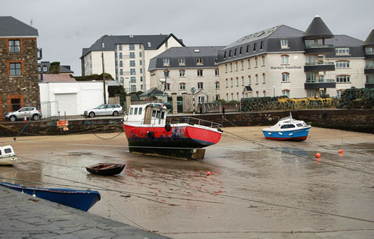
Nestling on the River Bandon as it sweeps to the sea, Kinsale emerged as a settlement in the 6th century and has seen many changes.
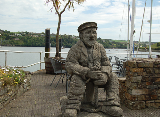
"Really there are three harbours here, the inner, the middle and the outer and Kinsale has changed over the years as it evolved to meet the many challenges," he said as we chatted overlooking the harbour from the front of the Trident Hotel where the statue of a fisherman, resting and thinking, reminds patrons that this too was once a big fishing port and still retains fishing boat activity.
"The harbour has always provided a safe anchorage and prospered during the golden age of sail, victualling shops bound for the American colonies, the West Indies and trading with English and Continental ports. Many people will remember it for the Battle of Kinsale, but there is much more to the town and the maritime tradition is its main reason for existence. There was a Naval base to restrict threats of foreign invasion, there were pirates and smugglers, it was a shipping port, it evolved when the size of ships changed, it was a big fishing industry centre, that changed too as the industry and stocks moved. It still retains some fishing and it became a sea angling centre which gave it a new life.
Now it is still very active in the marine, as a sailing centre. There have been difficult times here in Kinsale, but the way a town like this survives is to focus on what it has best, that is the maritime role, its maritime resources and facilities."
Even where we sat talking about Kinsale, where the Trident Hotel stands, he told me was once a dockyard.
"My mother's family was involved in the fishing industry, on my father's side the family were boatbuilders, owners and members of various boards and public bodies engaged in the affairs of the harbour.
"The story of Kinsale is the history of its connection with the sea. Everything about Kinsale is of the sea and so it should remain," says John Thullier, whose book about this major sailing location is well worth reading.
And if you want to know what happened to Anne the pirate, John Thullier says:
"No precise information is available about her after Rackham's hanging. There are reports that she abandoned piracy, was reconciled with her father, remarried and had eight more children."
I like a happy ending!
Twitter: @TomMacSweeney
Rivers That Flow Through Our Cities Should Be Utilised

#thisislandnation – We don't make enough use of the rivers which flow through our cities. These ribbons of life to our major urban centres pass through the heart of the cities where the pressure of traffic and pedestrians shows more interest in the speed with which they can be crossed, often seeming to regard them as unwelcome blocks which require bridges, rather than appreciate that underneath those bridges is a system of transport and leisure which is neglected and often used by citizens for dumping of their waste.
There are some moves to utilise them more efficiently. On the Liffey there is a sightseeing tourist vessel and Poolbeg maintains its sailing presence close to the shipping sector. In Cork a voluntary organisation, Meitheal Mara, has promoted boating on the many different strands into which the city forces the Lee to pass through. Cork's city-based shipping operations have been diminished by the port which wants to end them altogether and move commercial shipping to Ringaskiddy where its public presence will be more limited and removed from the public eye. Waterford has based a marina in the city centre, but shunted its shipping to Belview where it is practically unseen by the public, so that the contribution of shipping to the economy is not perceived as strongly as it should be. Galway is a restricted tidal port, but a new one is planned and close enough to be seen by citizens. Dublin maintains port operations close to the city.
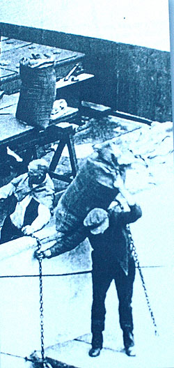
Dublin Port docker from the North Lotts book
There was a time when the ports and the rivers throbbed with life. In Dublin Guinness barges traversed the Liffey and there were real characters on the docks in all of our cities. Life could be tough as a dock labourer, but there was a great pride in the communities which lived around the ports and recognised the importance of shipping.
The East Wall has always been a proud Dublin community with seafaring a vital part of its tradition. On my programme THIS ISLAND NATION I played a song from a CD which was presented to me. 'Songs from the North Lotts' by Paul O'Brien capture a time in East Wall which deserves to be remembered. The East Wall Residents' Association which has been in existence for some fifty years, "maintaining and promoting the rare and wonderful community that it is an always has been," led the production of the book of the songs, dedicated to the people of East Wall and North Wall.
The song I played was "Taking the Boat," about which Paul O'Brien wrote in a book accompanying his CDs in 2009: "When I was growing up Dublin people didn't emigrate, they 'took the boat'. Single or married, it didn't matter. I don't personally know of any Dublin family that has not been touched by emigration."
There was a great response to the song, which you can hear on the Afloat website by CLICKING HERE. It was so good that in the June edition of the monthly programme, I will be playing another ballad from the collection – "Me Handsome Stevedore."
Tune in to hear it – next Wednesday night, June 4 at 7.30 pm on Youghal Radio – Community Radio Youghal 104FM or on their website www.cry104fm.com or if you are in the Dublin area, tune in to NearFM 90.3 on Friday night, June 6 at 6 p.m. This is another station joining the "family of the sea."
There was an interesting comment on the May edition of the programme by Jim O'Donovan, Director of Environment and Recreation with Cork City Council, who compared the better environmental condition of the River Lee to the Liffey, particularly around Heuston Station, about which he was quite critical.
Click HERE to listen to him on the Afloat podcast of the programme.
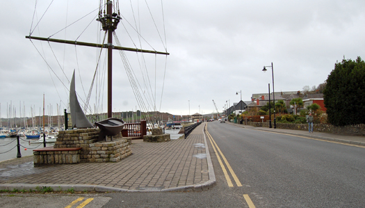
MARINE COMMUNITY GROWING
Waiting for the tide at Youghal in County Cork
Community radio stations around the country are showing great interest in the marine sphere and counteracting neglect by national and local commercial radio. I met many of these voluntary broadcasters at the annual meeting of their national organisation, CRAOL, over the past weekend in Youghal. They have produced and broadcast programmes on a wide variety of marine topics. THIS ISLAND NATION, was amongst the winners in the annual CRAOL national awards, chosen by the broadcasters themselves. I am pleased that the description "this island nation" is heard being more widely used in general conversation, by the media, in politics and in business. Awareness of the marine sphere is growing.
WHELKS, BIRDS AND FISHING
I didn't know a lot about the Irish sea snail which is worth around €4m. a year in exports until I talked to Liam Kennedy from the Sea Fisheries Protection Authority who wants fishermen to protect them. I will be broadcasting that interview in the June edition of THIS ISLAND NATION radio next week, as well as an exclusive interview with the Head of the SFPA, Susan Steele. She tells me that she wants to see "a thriving fishing industry and thriving fishing communities," but warns that those who "lose the run of themselves" and engage in illegal fishing will be dealt with speedily and effectively because they damage the future of the fishing industry. I will also be talking to Birdwatch Ireland about the arrival, for the first time, of one of the world's rarest sea birds off the Irish coast.
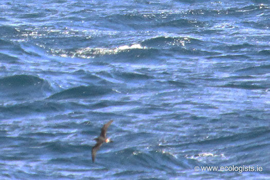
This is the Bermuda Petrel, an endangered species, of which there are only 108 breeding pairs known to exist.
WOMAN WITH CONFIDENCE
"We've never sailed in Cork before, but we're quite confident anyway." That's the view of the top woman match racing sailor, 32-year-old Camilla Ulrikkeholm from Denmark, who will be at the home of sailing, the Royal Cork YC in Crosshaven, for the ISAF Women's Match Racing World Championships will be staged there next week.
Camilla Ulrikkeholm from Denmark
The event will start on Tuesday and continue until Sunday, sailed in the ISA J80s fleet. "We've done a lot of research about the venue, we know the boat very well and we're definitely as tuned together as a crew should be. We'll just handle it the same way we usually do - arrive early to spend a day finding out all the practical details, then do some practising and get to know the boat and work our way into the regatta by using the first matches to learn about the local conditions."
That's confidence !
SHIPPING RECOVERY UNLIKELY
The Chief Executive of A.P.Moeller-Maersk Company has indicated that there will not be a sustainable recovery in the shipping industry in the short term. Nils Andersen is quoted as saying that "there is lingering overcapacity" which may remain until 2017. The Irish Maritime Development Organisation in its Weekly Market Review says that "the idle containership fleet" has gone below two per cent of the overall fleet for the first time since last September, but the global tanker market is experiencing low rates with the crude sector suffering particularly and providing only very low earnings for owners. The European Short Sea Bulk market is also experiencing a downward trend which has been developing since April.
BALTIMORE MARITIME COURSES
Baltimore Maritime Centre was formed in December 2013 by a nucleus of members of Les Glénans, following the closure of the Glenans sail training base in the village. It has acquired six of that organisation's keel boats and will start sailing courses this Summer in conjunction with Heir Island Sailing Schull and Baltimore Yacht Charters.
Twitter: @TomMacSweeney and @Afloatmagazine
Staying Out of the EU was Norway's Best Decision
#islandnation – In THIS ISLAND NATION this week .. How Norway preserves, protects and respects maritime tradition and its marine industries
STAYING OUT OF THE EU WAS THE BEST DECISION
I am in Norway this week where I have been looking at Europe's most diversified maritime nation. One of the most regular comments I have heard is that the country's best decision was to stay out of the European Union and maintain control over its own marine resources, from shipping to oil to fishing.
And of course they are of the Viking tradition and Ireland was well-known to those Vikings as a destination in past historic times when they raided our shores! Nowadays there is a growing Irish presence in Norway and even a GAA presence in Oslo.
Norway's overall maritime economy – an expanding cluster of industries linked to shipping, offshore oil and gas and the fishing and aquaculture industry encompasses a wide variety of products and services. It has gained worldwide respect for its shipping expertise, equipment and ability to exploit new market niches.
There is also huge respect for its maritime history, with the traditions maintained and achievements of individuals honoured presented in museums which are located at many places around the country. The shipbuilding industry comprises internationally competitive, technically-advanced small and medium-sized shipyards, focussing on ship repair and the construction of specialised vessels including ro-ros, chemical tankers, advanced fishing vessels, reefers, offshore supply ships, high-speed catamarans, cable-laying ships and seismic exploration vessels.
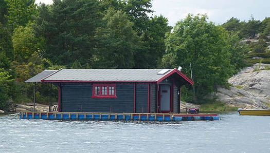
The latest thing in Norway, floating cabins that can be towed around
While Irish government Ministers defend what have been challenged by trade unions and other commentators as terms which favour exploration companies making finds in Irish waters to the disadvantage of the Irish people, revenues from Norwegian oil and gas activity are, amongst other benefits in taxation derived for the nation's economy, invested in a government pension fund, so that the country's petroleum wealth will benefit future generations. This fund makes long-term investments throughout the world. Called the "oil fund" its operations are well-known to the general public. "Openness and ethical considerations are cornerstones in the fund's investment strategy," government sources told me:
"Only the yield is used. The State is not allowed to use more of the oil revenues than the fund's anticipated real rate of return over time. As a result, short-term changes in oil and gas prices have little impact on budget policy."
SAILING IS BEAUTIFUL BUT DIFFERENT
Sailing the fjords of Norway is a delight. At islands dotted along the coastal areas there are mooring points driven into the rocks to which a boat can be tied and, with constant depth, there is no fear of grounding while moored. It does take a different type of mindset though, to what we Irish are used to, in sailing the boat towards the rocks! Travelling between towns and villages by boat is a regular means of transport. Most people seem to own a boat of some size.
FISHING IS THE BACKBONE
The fisheries industry is the backbone of coastal Norway. Fisheries, aquaculture and fish processing provide employment for more than 30,000 people. The annual export value of fish and fish products is around NOK 30 billion, (about €5 billion Euro) making this one of Norway's largest export sectors. "It is therefore of crucial importance to Norway to ensure sound management of living marine resources," I was told.
The fishing industry, free of the EU's restrictions, provides smoked and cured salmon, cod, monkfish and halibut. Herring and shellfish are also very popular and, unlike the controls of the EU which have sought to prevent the buying of fish straight from the boats in Irish fishing ports, in Norway you can get a bag of shrimps fresh from the fisherman's boat and enjoy it with an ice-cold beer on the quayside!
Most of the Norwegian fish catch is taken in the Norwegian Exclusive Economic Zone (EEZ) waters, covering about 2 million kilometres. There are agreements with Russia and the EU about fishing but, as with the mackerel dispute, the country strongly protects its own resources and has made this clear to the EU whose failed Common Fisheries Policy is considered a disaster that has damaged fishing within the European Union.
Seals are hunted and stocks in the East Ice are managed by the Norwegian-Russian Fisheries Commission. The North Atlantic Marine Mammal Commission (NAMMCO) is a forum for co-operation on the conservation, management and study of marine mammals in general. Minke whale harvesting is managed unilaterally by Norway and disagreement continues about this, though it seemed to me that whale meat is not as popular as it used to be.
"The over-riding goal of Norwegian management of living marine resources is to ensure their sustainable use, to ensure that the harvest is adapted to the capacity of the stocks to renew themselves. Traditionally, fish stocks have been managed in a single-species perspective. However, one species may have a considerable impact on a number of other species: for example, both cod and Norwegian spring-spawning herring feed extensively on capelin in the Barents Sea and whales and seals make heavy inroads into stocks of various fish species and organisms on which they feed. Temperature and other environmental factors also influence the migration and development of different stocks."
The ecosystem approach is increasingly being applied to fisheries management, taking into account how harvesting affects fish stocks, but also how the fisheries affect the marine environment in general, and the consequences of changes in the marine environment for living marine resources.
The fishing industry and the fisheries authorities co-operate in the formulation of the regulatory regime. However, the Minister of Fisheries takes the final decisions on management measures. Fisheries legislation is enforced both at sea and when the fish is landed. At sea, the Coast Guard is responsible for inspecting fishing vessels and their catches. Foreign vessels that are fishing in waters under Norwegian jurisdiction are also inspected.
Email your comments on maritime matters to : [email protected]
Follow Tom for more maritime news and comment on Twitter: @TomMacSweeney


, and Dermot O’Kane, Head of Sales, Esri Ireland. Esri Ireland is announcing that its digital mapping system is helping DURL to prevent 13 million litres of polluted wastewater from entering Dublin rivers annually, by locating misconnected household appliances that are expelling polluted water")


