Menu

Ireland's sailing, boating & maritime magazine

Inland afloat headers


Displaying items by tag: Titanic

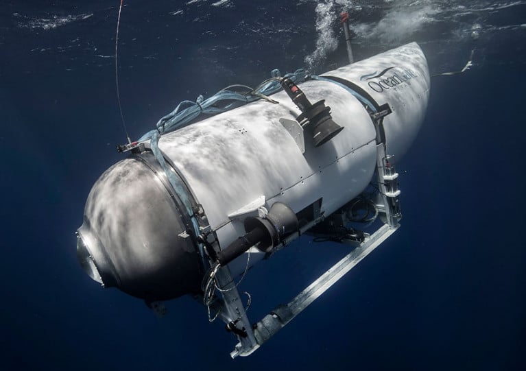
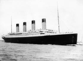
For the first time in 15 years, paying guests will soon be taken nearly four kilometres beneath the ocean’s surface to visit the wreck of the RMS Titanic.

According to Bloomberg, a company called OceanGate Expeditions will launch its dive expeditions and research missions next May using a privately owned five-person mini-submarine.

And already more than 30 eager explorers have signed up at $125,000 (€105,260) apiece for the privilege of getting close to the remains of the ill-fated, Belfast-built ocean liner, which struck and iceberg in the North Atlantic in 1912 just days after her last port of call in Cobh.

While the planned deepwater voyages are for profit, the company insists that research is at their heart, and paying guests will take on the role of citizen scientists as they assist in a technical survey of the wreck site.

Bloomberg has much more on the story HERE.

Published in Titanic
Tagged under

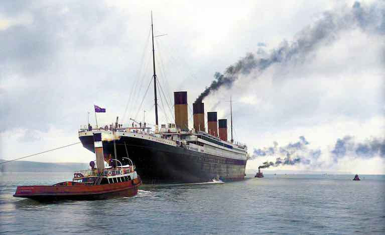
Old Ireland in Colour celebrates the rich history of Ireland and the Irish through the colour restoration of stunning images of all walks of Irish life, and the Irish abroad, throughout the nineteenth and twentieth centuries. From the chaos of the Civil War to the simple beauty of the islands, the book also includes retouched photos of RMS Titanic leaving Belfast Port. Each image has been exquisitely transformed and every page is bursting with life.

Old Ireland in Colour started in 2019 when John Breslin developed an interest in historic photo colourisation, enhancement and restoration through personal genealogical research. He began to
colourise old family photos – photos of his grandparents from Fanore in Co. Clare and Glenties in Co. Donegal. Using a combination of cutting-edge artificial intelligence technology and his own historical research, John moved from family photographs to photographs of Galway and Connemara, and then on to others taken across the island of Ireland in the nineteenth and twentieth centuries.

On board the TitanicOn board the Titanic

A first class cabin interior on the TitanicA first-class cabin interior on the Titanic

After a few months, the Old Ireland in Colour project was born. For this beautiful book, John has meticulously colourised a varied and fascinating selection of images, with breath-taking attention to detail and authenticity. With photographs from all four provinces, and accompanied by fascinating captions by historian Sarah-Anne Buckley, Old Ireland in Colour revitalises scenes we thought we knew, and brings our past back to life before our eyes.

The front cover of the Old Ireland in Colour book that is out nowThe front cover of the Old Ireland in Colour book that is out now

John Breslin is a Professor at NUI Galway, where he has taught engineering, computer science and entrepreneurship over a twenty-year period. Dr Sarah-Anne Buckley is a lecturer in History at NUI Galway and President of the Women’s History Association of Ireland. She is co-founder of the Irish Centre for the Histories of Labour and Class.

Published in Book Review
Tagged under

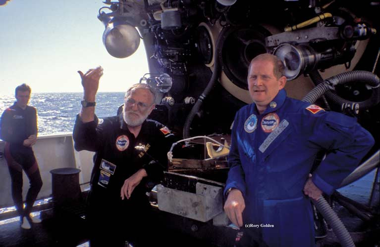
Irish deep-sea diver Rory Golden is providing expertise to a new expedition to the Titanic which aims to recover the Marconi radio from the wreck, The Sunday Times reports.

The wireless Marconi telegraph was instrumental in saving more than 705 passengers from freezing Atlantic waters when the ship sank after striking an iceberg off Newfoundland in April 1912 with the loss of almost 1500 lives.

As Afloat reported previously, the ambitious project to retrieve the most famous marine radio in the world from 2.5 miles down in the Atlantic has finally secured legal approval.

The new expedition planned by RMS Titanic Inc, the salvor-in-possession, will be led by Dr David Gallo and French former naval officer Paul Henri Nargeolet.

Dublin-based Golden, who was the first Irish diver to visit the wreck site in almost 4,000 metres of water, has been engaged as a consultant to the company which has recovered over 5,500 artefacts in eight previous expeditions.

The former managing director of Virgin Records Ireland was dive safety operations manager for the Operation Titanic 2000 project which recovered 800 items - including the main ship’s wheel which he spotted. He returned in 2005 for a second dive, which was recorded in a BBC documentary.

In March 2013 he was a member of the team sponsored by Amazon.com founder Jeff Bezos which salvaged five Apollo F-1 rocket engines from 4200 metres in the North Atlantic, including one from Apollo 11 which launched a man to the moon in 1969.

Golden’s participation is one of several Irish connections to the new diving expedition which is expected to cost at least 10 million US dollars.

A Mayo community’s support for the new venture also helped to secure recently approved US Admiralty Court permission for it.

A letter to the US Admiralty Court from Addergoole Titanic Society director Toss Gibbons, secretary Mary Rowland and public relations officer Frank Gibbons urged that it would “give its blessing” to RMS Titanic Inc to undertake the expedition. The society remembers 11 of the ship’s fatalities from the Mayo village of Laherdane and surrounding area.

“We spent a lot of time in Ireland, in Belfast and with the folks in Addergoole to put a plan together which would satisfy the court,” RMS Titanic Inc president Bretton Hunchak said.

The recovery of the Marconi telegraph is crucial to understanding “the story of all of the survivors”, Hunchak explained.

The Marconi Telegraph room as seen from the top of the Titanic Photo: Rory GoldenThe Marconi Telegraph room as seen from the top of the Titanic Photo: Rory Golden

“Ultimately, the Marconi radio system remains an unsung hero, responsible for countless generations of families that exist only because the radio cried out on behalf of their ancestors,” he said.

“ For that reason, we must recover this incredible piece of history, to rescue the radio that saved 705 lives from being taken from the world that fateful night."

The hatch to the Marconi Room Photo: Rory GoldenThe hatch to the Marconi Room Photo: Rory Golden

Hunchak said the original plan for the expedition was within a weather window between June and August of this year, and that might still take place.

“Obviously, with the Covid-19 pandemic, we have questions now and will make a decision on timing very shortly,” he said.

“The Marconi telegraph is recognisable, from our underwater photography, but if we recover it there will be considerable conservation required before we can take it around the world as part of our exhibition of artefacts,” he said.

Golden said the project was “fraught with a lot of unknown and known variables, such as the condition of the roof area, the wreck itself, currents, visibility” and other factors, but has “a very good chance of succeeding”.

The wreck of the Titanic was discovered by Dr Robert Ballard and Jean Louis Michel in a joint US/ French expedition on September 1st, 1985, some 963 miles northeast of New York and 453 miles southeast of the Newfoundland coastline.

More on the Sunday Times report here

Published in Titanic
Tagged under

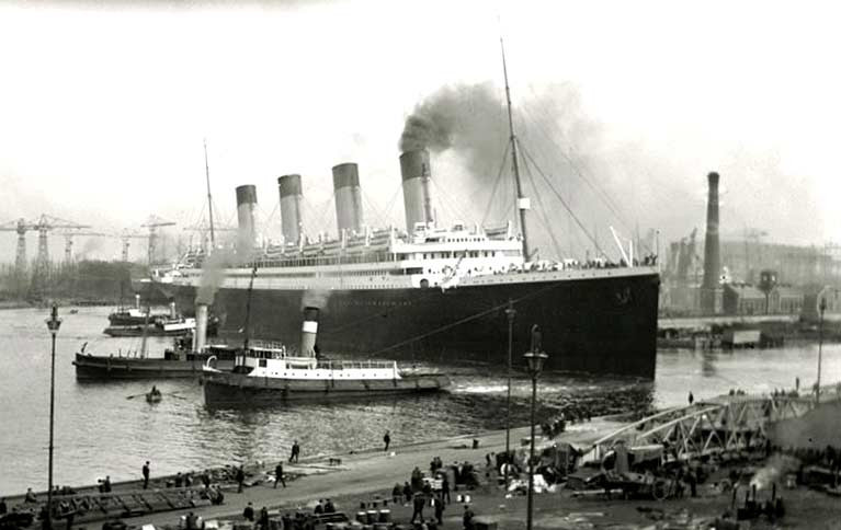
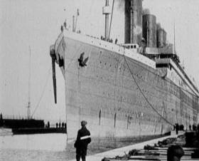
An ambitious project to retrieve the most famous marine radio in the world from 2.5 miles down in the Atlantic has finally secured legal approval. The saving of the Marconi radio which sent out the distress signals from the sinking Titanic after she'd struck a North Atlantic iceberg en route to New York on 14th April 1912 has finally been given approval in a US court. And if the project is successful, it will be a very tangible reminder of a special link between Belfast and Dublin.

The Titanic was built in Belfast in a massive seven-year project between 1907 and 1912, and towards its conclusion, her legendary “Radio Shack” was installed with the latest in marine radios from the Marconi company. The company was founded and its best ideas provided by Gugliemo Marconi, whose father was Italian, but whose mother was Annie Jameson of the long-established Dublin whiskey-distilling company, a family renewed for their long and successful association with sailing.

This had been underlined in 1904 when the young Marconi’s new invention was used to transmit sailing results for the first time ever from an event afloat to national newspaper, the event being the regatta of Royal St George Yacht Club in Dublin Bay. The Jameson family had been closely associated with the club since at least the 1840s, and possibly since its formation in 1838.

The Guardian has the story of the proposed radio retrieval here

Guglielmo MarconiMake mine a Jameson……radio pioneer Gugliemo Marconi definitely had the look of one of the more serious Jamesons, which is not surprising as his mother Annie was of the famous Dublin whiskey-distilling family

Published in Titanic
Tagged under

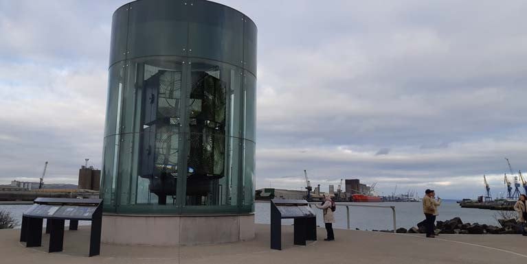
At the end of the 500 metre Titanic Walkway which connects the Titanic and Olympic Slipways to the Alexandra Dock in Belfast’s Titanic Quarter, proudly sits The Great Light, a curved glass interpretive structure designed to resemble a lighthouse lantern room. The lens inside began life atop the lighthouse on Tory Island and in the 1920s replaced the Mew Island light on one of the three Copeland Islands off the North Down Coast. It’s journey to the Walkway was by helicopter, the ILV Granuaile and a store in Dun Laoghaire.

The Copelands lie on the south side of the North Channel, and posed a great danger to shipping, especially when trade in and out of Belfast Harbour increased. Over three hundred years ago the first Lighthouse was built on Lighthouse Island but as Mew Island was more difficult to see, especially at night, a new one was built there in 1884.

In the 1920s the Mew Island light was reported to be flashing irregularly so in 1928 it was replaced with eight of the lens panels from the Hyper - Radial Optic on Tory and it is this light which has earned a place in the world-famous Titanic Quarter.

The Great Light, at seven feet tall, is one of the largest optics of its kind in the world and weighs 10 tonnes. This irreplaceable heritage object is hugely significant to Belfast’s economic, maritime and industrial past.

By the 21st century, advanced light technology meant the lighthouse’s huge lens was no longer needed and in 2014 they were replaced by solar panels, a LED light, a radar beacon and AIS.

Recognising the Light’s historical importance, the Titanic Foundation charity was awarded funding for saving, restoring and displaying the optic, and with the help of many organisations including the Commissioners of Irish Lights who contributed and restored the optics, Belfast Harbour who donated the site and the Titanic Quarter who provided the Walkway, the Great Light can now be viewed by the public.

During sixteen weeks work in 2015, many parts were helicoptered to the Granuaile, the heaviest parts were towed under a buoy to the ship and the Irish Lights vessel took all the optic’s parts to Dun Laoghaire. Finally, the site was opened in November 2018 and with free public access, it tells the story of lighthouses, their technological development, the keeper and their role in the maritime and industrial history of Belfast and Ulster.

Tagged under

Deputy Lord Mayor of Belfast, Councillor Peter McReynolds, has attended an event today to welcome the Belfast Buoys to their new home in Titanic Quarter, where they will remain on permanent display.

The buoys were given to Belfast City Council by the Commissioners of Irish Lights in 1983 and originally located in the Cathedral Gardens, which became affectionately known as 'Buoy Park'.

Regeneration of the area around Ulster University and the development of Titanic Quarter prompted plans for the buoys to find a new home near Abercorn Basin, as part of the Department for Communities’ Streets Ahead Project.

In January 2019, the landmarks were taken to the Irish Lights headquarters in DunLaoghaire for restoration. The distinctive buoys - which celebrate the city's maritime heritage – took up residence on the quays just as the Tall Ships arrived for the Belfast Titanic Maritime Festival.

Each buoy weighs around 3 tonnes and is made of thick steel plates riveted together. They are hollow structures, filled with air to allow them to float, and they would have been secured in place by mooring chains, attached to a cast iron sinker sitting on the seabed.

Deputy Lord Mayor of Belfast, Councillor Peter McReynolds, said: “It is wonderful to visit the Belfast Buoys and to see these iconic symbols of Belfast at their new home. Given their proximity to the water, in such a popular area for locals and tourists, their move to Titanic Quarter is very fitting.

“Belfast City Council, along with our city partners, is committed to increasing the value of tourism by £500 million by 2021 as part of the Belfast Agenda, the community plan for the city. Capitalising on our rich maritime heritage is an important part of the mix, and relocating the buoys to the Maritime Mile will assist by adding to the area’s growing appeal to visitors.”

James Eyre, Commercial Director of Titanic Quarter Ltd, said: “We are delighted that these iconic landmarks have been relocated to Titanic Quarter and we are very grateful for the support and dedication from our partners; Titanic Foundation, Belfast City Council, Department for Communities, Belfast Harbour and Commissioners of Irish Lights, for delivering such a fantastic project. Known for its rich maritime heritage, Titanic Quarter attracts 1 million visitors annually and has acquired the status of a premier global destination for leisure and business tourism. We look forward to welcoming more visitors to the Buoys over the summer months.”

Kerrie Sweeney, Chief Executive of Titanic Foundation, added: “We would like to thank the Commissioners of Irish Lights who have restored the buoys and repainted them in their traditional navigational colours. The three buoys are estimated to be around 80 years old, and would have been used by mariners to find a safe channel to and from port. Similar buoys would have been used in Belfast Harbour, marking the edges of the narrow Victoria Channel. The Buoys are an amazing addition to the Maritime Mile and it’s a fantastic opportunity for everyone to explore the city’s rich maritime heritage.”

Mark O’Donnell from the Department for Communities said: “The Department is delighted to assist in the relocation of the Belfast Buoys from their old location in Cathedral Gardens to their new home in the Titanic Quarter. The new installation will complement the other unique attractions that are part of the Maritime Mile whilst also allowing for the redevelopment of Cathedral Gardens into an exciting new civic space.”

Published in Titanic
Tagged under

Collective shame about the Titanic’s sinking, accounts by survivors, Belfast shipyard Harland and Wolff’s role, and fears by some local politicians some decades later of a “Dublin-based developer” coming to “rape and pillage” are among themes explored in a documentary due to be broadcast on TG4 television next week.

Extensive archive footage and interviews with renowned Titanic experts form the basis for City of a Thousand Launches (italics), which was made five years ago and focuses on Northern Ireland’s links with one of the worst maritime disasters of the early 20th century – described as the “9/11” of 1912.

Over 1500 people died and over 700 were rescued when the Belfast-built passenger liner sank after hitting an iceberg off the Newfoundland coast on April 14th-15th, 1912, while en route from Southampton to New York.

British Queen Elizabeth, former US secretary of state Hillary Clinton and the diver who discovered the wreck of the ship, Dr Robert Ballard, number among over five million people from 145 countries who have visited the award-winning Titanic Belfast visitors’ centre. However, for decades, Belfast people did not talk about the ship, and it was James Cameron’s epic 1997 film which is said to have shifted attitudes.

Dr. Ballard DiscovererDr Robert Ballard – the diver who discovered the wreck of the ship

“They thought that it was their fault,” Dr Ballard says, while Rev Chris Bennett, an avowed “Titanorack”, articulates the shame felt about the shipyard’s connection.

The documentary charts how after the Harland and Wolff shipyard, once employer of over 30,000, was sold for redevelopment and how there was a fear among some city councillors “ about a Dublin-based developer coming up to Belfast to…rape and pillage”.

US architect Eric Kuhne’s design for the “Titanic quarter” waterfront area, and the concept of a world class visitor centre, reflected the city’s changed attitude towards the ship, but the documentary explores the struggle to realise the vision and the risk taken by Donegal developer Pat Doherty to start building with no official contracts in place.

“ That was it, this sucker was getting built…and it was getting built with a vengeance!” Kuhne recalls.

Titanic Belfast - City of a Thousand Launches will be broadcast on TG4 on April 10th at 9.30pm.

Published in Titanic
Tagged under

#Titanic - For decades it was believed that the ill-fated Titanic was sunk by an iceberg on its maiden transatlantic voyage.

Indeed, the dramatic collision and its aftermath has long been etched on the Irish consciousness, and was the centrepiece of 1997’s Oscar-winning epic.

But now experts have claimed that the iceberg was only the final straw of a calamitous journey whose fate was sealed by an unnoticed fire in its hull some three weeks before, as Independent.ie reports.

Previously only theorised by experts on the ocean liner and its demise in 1912, the fire’s status as the primary cause of the Titanic’s demise has now been all but confirmed after new analysis of photographs of the vessel before it left the Harland & Wolff shipyard in Belfast.

These appear to show scorch marks on the hull close to the spot where it was later breached by contact with the iceberg — lending credence to the idea that the ship was already fatally weakened by the incredible heat of a fire inside.

Journalist Senan Molony, who fronted a Channel 4 documentary on his findings on New Year’s Day, also makes the bold claim that the White Star Line covered up the fire incident even before the Titanic launched from Southampton.

“Nobody has investigated these marks before,” said Molony. “It totally changes the narrative.”

Independent.ie has much more on the story HERE.

Published in Titanic
Tagged under

#TitanicBrexit - Belfast’s Titanic Quarter, which is home to Northern Ireland’s and Europe's most popular tourist attraction, has reported losses for last year of £333,111 (€383,329), newly filed accounts show.

Titanic Island Limited, which controls the group of companies working in the quarter, said pretax losses narrowed from £1.16 million in 2014. The group previously reported a £68,000 loss for 2014, down from £33.9 million in 2013. It said the previous year’s results had been restated due to a transition to the FRS 102 reporting standard.

Turnover totalled £10.9 million for 2015 with operating profit rising from £1.96 million to £2.49 million.

For more on the potential of the Brexit impact to one of the world’s largest urban-waterfront regeneration projects, the Irish Times has a report by clicking here.

Published in Titanic

#Britannic - A new book promises to answer what really happened to a sister ship of the Titanic that met a similar fate, as the Belfast Telegraph reports.

Mystery of the Last Olympian tells the story of the Britannic, which sank in the Aegean Sea following a explosion on 21 November 1916 while drafted as a hospital ship during the First World War.

All but 30 of its 1,065 passengers and crew were rescued after the incident, which saw the ship go under twice as fast as the ill-dated Titanic more than four years earlier.

And the facts of the Britannic's demise have been a mystery ever since, with claims that the vessel struck a German mine dismissed by others who believe a U-boat torpedo was to blame.

Co-author Richie Kohler, the only person to dive both the Titanic and Britannic wrecks, also set out to discover if structural changes to the latter vessel would indicate that Harland & Wolff and the White Star line "had reason to believe the Titanic had broken apart on the surface - a claim refuted at the time."

The Belfast Telegraph has more on the story HERE.

Published in Titanic
Tagged under
Page 2 of 8

General Information on using Waterways Ireland inland navigations

Safety on the Water

All users of the navigations are strongly recommended to make themselves aware of safety on the water for whatever activity they are involved in and to read the advice offered by the various governing bodies and by:

The Dept. of Transport, Ireland: www.gov.ie/transport and The Maritime and Coastguard Agency, UK, The RNLI – Water Safety Ireland for information in terms of drowning prevention and water safety.

Registration of Vessels

All vessels using the Shannon Navigation, which includes the Shannon-Erne Waterways and the Erne System must be registered with Waterways Ireland. Only open undecked boats with an engine of 15 horsepower or less on the Shannon Navigation, and vessels of 10 horsepower or less on the Erne System, are exempt. Registration is free of charge.

Craft registration should be completed online at: https://www.waterwaysireland.org/online-services/craft-registration

Permits for use of the Grand and Royal Canals and the Barrow Navigation

All vessels using the Grand and Royal Canals and the Barrow Navigation must display appropriate valid Permit(s) i.e A Combined Mooring and Passage Permit (€126) and if not intending to move every five days, an Extended Mooring Permit (€152).

Permit applications should be completed online at: https://www.waterwaysireland.org/online-services/canal-permits

Passage on the Royal and Grand Canals – Dublin Area

For boat passage through the locks east of Lock 12 into / out of Dublin on either the Royal or Grand Canals, Masters are requested to contact the Waterways Ireland Eastern Regional Office (M-F 9.30am-4.30pm) on tel: +353(0)1 868 0148 or email [email protected] prior to making passage in order to plan the necessary lock-keeping assistance arrangements.

On the Grand Canal a minimum of two days notice prior to the planned passage should be given, masters should note that with the exception of pre-arranged events, a maximum of 2 boats per day will be taken through the locks, travelling either east or west.

Movements in or out of the city will be organised by prior arrangement to take place as a single movement in one day. Boaters will be facilitated to travel the system if their passage is considered to be safe by Waterways Ireland and they have the valid permit(s) for mooring and passage.

Newcomen Lifting Bridge

On the Royal Canal two weeks’ notice of bridge passage (Newcomen Lifting Bridge) is required for the pre-set lift date, and lock assistance will then also be arranged. A minimum of 2 boats is required for a bridge lift to go ahead.

Waterways Ireland Eastern Regional Office (Tel: +353(0)1 868 0148 or [email protected] ) is the point of contact for the bridge lift.

A maximum number of boats passing will be implemented to keep to the times given above for the planned lifts (16 for the Sat / Sun lifts & 8 for the weekday lifts). Priority will be given on a first come first served basis.

On day of lift, boaters and passengers must follow guidance from Waterways Ireland staff about sequence of passage under bridge & through Lock 1, and must remain within signed and designated areas.

Events Held on the Waterways

All organised events taking place on the waterways must have the prior approval of Waterways Ireland. This is a twelve week process and application forms must be accompanied with the appropriate insurance, signed indemnity and risk assessment. The application should be completed on the Waterways Ireland events page at :

https://www.waterwaysireland.org/online-services/event-approval

Time Limits on Mooring in Public Harbours

On the Shannon Navigation and the Shannon-Erne Waterway craft may berth in public harbours for five consecutive days or a total of seven days in any one month.

On the Erne System, revised Bye Laws state that: No master or owner shall permit a vessel, boat or any floating or sunken object to remain moored at or in the vicinity of any public mooring, including mooring at any other public mooring within 3 kilometres of that location, for more than 3 consecutive days and shall not moor at that same mooring or any other public mooring within 3 kilometres of that location within the following 3 consecutive days without prior permission by an authorised official.

Winter Mooring on the Shannon Navigation and Shannon Erne Waterway

Winter mooring may be availed of by owners during the period 1 Nov to 31 Mar by prior arrangement and payment of a charge of €63.50 per craft. Craft not availing of Winter Mooring must continue to comply with the “5 Day Rule”. Winter Mooring applications should be completed online at : https://www.waterwaysireland.org/online-services/winter-moorings-booking

Owners should be aware that electricity supply and water supply to public moorings is disconnected for the winter months. This is to protect against frost damage, to reduce running costs and to minimise maintenance requirements during the winter months.

Vessel owners are advised that advance purchasing of electricity on the power bollards leading up to the disconnection date should be minimal. Electricity credit existing on the bollards will not be recoverable after the winter decommissioning date. Both services will be reinstated prior to the commencement of the next boating season.

Smart Cards

Waterways Ireland smart cards are used to operate locks on the Shannon Erne Waterway, to access the service blocks, to use the pump-outs along the navigations, to avail of electrical power at Waterways Ireland jetties.

Berthing in Public Harbours

Masters are reminded of the following:

  • Equip their vessel with mooring lines of appropriate length and strength and only secure their craft to mooring bollards and cleats provided for this purpose.
  • Ensure the available berth is suitable to the length of your vessel, do not overhang the mooring especially on finger moorings on floating pontoon moorings.
  • Ensure mooring lines, electric cables and fresh water hoses do not create a trip hazard on public jetties for others users.
  • Carry sufficient fenders to prevent damage to your own vessel, other vessels and WI property.
  • Allow sufficient space between your vessel and the vessel ahead /astern (c.1m) for fire safety purposes and /or to recover somebody from the water.
  • Do not berth more than two vessels side by side and ensure there is safe access/egress at all times between vessels and onto the harbour itself.
  • Do not berth in such a way to prevent use of harbour safety ladders, slipways or pump-outs.
  • Do not allow the bow of your vessel to overhang the walkway of a floating mooring thus creating a hazard for others with an overhanging anchor or bow fendering.
  • Animals are not allowed to be loose or stray at any time.
  • Harbour and jetty infrastructure such as railings, power pedestals, fresh water taps, electric light poles, safety bollards, ladders etc are not designed for the purpose of mooring craft , they will not bear the strain of a vessel and will be damaged.
  • At Carrybridge on the Erne System, Masters of vessels are not permitted to use stern on mooring. Masters of vessels must use the mooring fingers for mooring of vessels and for embarkation / disembarkation from vessels.

Passenger Vessel Berths

Masters of vessels should not berth on passenger vessel berths where it is indicated that an arrival is imminent. Passenger vessels plying the navigations generally only occupy the berths to embark and disembark passengers and rarely remain on the berths for extended periods or overnight.

Lock Lead-in Jetties

Lead-in jetties adjacent to the upstream and downstream gates at lock chambers are solely for the purpose of craft waiting to use the lock and should not be used for long term berthing.

Vessel Wake

Vessel wake, that is, the wave generated by the passage of the boat through the water, can sometimes be large, powerful and destructive depending on the hull shape and engine power of the vessel. This wake can be detrimental to other users of the navigation when it strikes their craft or inundates the shoreline or riverbank. Masters are requested to frequently look behind and check the effect of their wake / wash particularly when passing moored vessels, on entering harbours and approaching jetties and to be aware of people pursuing other activities such as fishing on the riverbank.

Speed Restriction

A vessel or boat shall not be navigated on the Shannon Navigation at a speed in excess of 5 kph when within 200 metres of a bridge, quay, jetty or wharf, when in a harbour or canal or when passing within 100 metres of a moored vessel or boat.

Vessels navigating the Shannon-Erne Waterway should observe the general 5 kph speed limit which applies along the waterway. This is necessary in order to prevent damage to the banks caused by excessive wash from vessels.

Vessels navigating the Erne System should observe the statutory 5kt / 6mph / 10kph speed limit areas.

A craft on the Royal and Grand canals shall not be navigated at a speed in excess of 6km per hour.

A craft on the Barrow Navigation shall not be navigated at a speed in excess of 11km per hour except as necessary for safe navigation in conditions of fast flow.

Bank Erosion

Narrow sections of all the navigations are particularly prone to bank erosion due to the large wash generated by some craft. Masters are requested to be vigilant and to slow down to a speed sufficient to maintain steerage when they observe the wash of their craft inundating the river banks.

Unusual Waterborne Activity

Unusual waterborne vessels may be encountered from time to time, such as, hovercraft or amphibious aircraft / seaplanes. Masters of such craft are reminded to apply the normal “Rule of the Road” when they meet conventional craft on the water and to allow extra room to manoeuvre in the interest of safety.

Sailing Activity

Mariners will encounter large numbers of sailing dinghies from late June to August in the vicinity of Lough Derg, Lough Ree and Lower Lough Erne. Sailing courses are marked by yellow buoys to suit weather conditions on the day. Vessels should proceed at slow speed and with due caution and observe the rules of navigation when passing these fleets, as many of the participants are junior sailors under training.

Rowing

Mariners should expect to meet canoes and vessels under oars on any part of the navigations, but more so in the vicinity of Athlone, Carrick-on-Shannon, Coleraine, Enniskillen and Limerick. Masters are reminded to proceed at slow speed and especially to reduce their wash to a minimum when passing these craft as they can be easily upset and swamped due to their very low freeboard and always be prepared to give way in any given traffic situation.

Canoeing

Canoeing is an adventure sport and participants are strongly recommended to seek the advice of the sport’s governing bodies i.e Canoeing Ireland and the Canoe Association of Northern Ireland, before venturing onto the navigations.

Persons in charge of canoes are reminded of the inherent danger to these craft associated with operating close to weirs, sluice gates, locks and other infrastructure particularly when rivers are in flood and large volumes of water are moving through the navigations due to general flood conditions or very heavy localised precipitation e.g. turbulent and broken water, stopper waves. Shooting weirs is prohibited without prior permission of Waterways Ireland.

Canoeists should check with lockkeepers prior entering a lock to ensure passage is done in a safe manner. Portage is required at all unmanned locks.

Canoe Trail Network – "Blueways"

Masters of powered craft are reminded that a canoe trail network is being developed across all navigations and to expect more organised canoeing along these trails necessitating slow speed and minimum wash when encountering canoeists, rowing boats etc

Rockingham and Drummans Island Canals – Lough Key

It is expected that work on Rockingham and Drummans Island Canals on Lough Key will be completed in 2021. Access to these canals will be for non-powered craft only, eg canoes, kayaks, rowing boats.

Fast Powerboats and Personal Watercraft (Jet Skis)

Masters of Fast Powerboats (speed greater than 17kts) and Personal Watercraft (i.e.Jet Skis) are reminded of the inherent dangers associated with high speed on the water and especially in the confines of small bays and narrow sections of the navigations. Keeping a proper look-out, making early alterations to course and /or reducing speed will avoid conflict with slower vessels using the navigation. Personal Watercraft are not permitted to be used on the canals.

Towing Waterskiers, Wakeboarders, Doughnuts etc

Masters of vessels engaged in any of these activities are reminded of the manoeuvring constraints imposed upon their vessel by the tow and of the added responsibilities that they have to the person(s) being towed. These activities should be conducted in areas which are clear of conflicting traffic. It is highly recommended that a person additional to the master be carried to act as a “look-out” to keep the tow under observation at all times.

Prohibition on Swimming

Swimming in the navigable channel, particularly at bridges, is dangerous and is prohibited due to the risk of being run over by a vessel underway in the navigation.

Age Restrictions on operating of powered craft

In the Republic of Ireland, Statutory Instrument 921 of 2005 provides the legal requirements regarding the minimum age for operating of powered craft. The Statutory Instrument contains the following requirements:

- The master or owner of a personal watercraft or a fast power craft shall take all reasonable steps to ensure that a person who has not attained the age of 16 years does not operate or control the craft

- The master or owner of a pleasure craft powered by an engine with a rating of more than 5 horse power or 3.7 kilowatts shall take all reasonable steps to ensure that a person who has not attained the age of 12 years does not operate or control the craft.

Lifejackets and Personal Flotation Devices (PFDs)

Lifejackets and PFD’s are the single most important items of personal protective equipment to be used on a vessel and should be worn especially when the vessel is being manoeuvred such as entering / departing a lock, anchoring, coming alongside or departing a jetty or quayside.

In the Republic of Ireland, Statutory Instrument 921 of 2005 provides the legal requirements regarding the wearing of Personal Flotation Devices. The Statutory Instrument contains the following requirements:

- The master or owner of a pleasure craft (other than a personal watercraft) shall ensure, that there are, at all times on board the craft, sufficient suitable personal flotation devices for each person on board.

- A person on a pleasure craft (other than a personal watercraft) of less than 7 metres length overall shall wear a suitable personal flotation device while on board an open craft or while on the deck of decked craft, other than when the craft is made fast to the shore or at anchor.

- The master or owner of a pleasure craft (other than a personal watercraft) shall take all reasonable steps to ensure that a person who has not attained the age of 16 years complies with paragraph above.

- The master or owner of a pleasure craft (other than a personal watercraft), shall take all reasonable steps to ensure that a person who has not attained the age of 16 years wears a suitable personal flotation device while on board an open craft or while on the deck of a decked craft other than when it is made fast to the shore or at anchor.

- The master or owner of a pleasure craft (other than a personal watercraft) shall take all reasonable steps to ensure that a person wears a suitable personal flotation device, at all times while – (a) being towed by the craft, (b) on board a vessel or object of any kind which is being towed by the craft.

Further information is available at: http://www.irishstatutebook.ie/eli/2005/si/921/made/en/print

Firing Range Danger Area – Lough Ree

The attention of mariners is drawn to the Irish Defence Forces Firing Range situated in the vicinity of buoys No’s 2 and 3, on Lough Ree on the Shannon Navigation. This range is used regularly for live firing exercises, throughout the year, all boats and vessels should stay clear of the area marked with yellow buoys showing a yellow "X" topmark and displaying the word "Danger".

Shannon Navigation, Portumna Swing Bridge Tolls

No attempt should be made by Masters’ of vessels to pay the bridge toll while making way through the bridge opening. Payment will only be taken by the Collector from Masters when they are secured alongside the jetties north and south of the bridge.

Navigating from Killaloe to Limerick on the Shannon Navigation

The navigation from Killaloe to Limerick involves passage through Ardnacrusha locks, the associated headrace and tailrace and the Abbey River into Limerick City. Careful passage planning is required to undertake this voyage. Considerations include: lock passage at Ardnacrusha, water flow in the navigation, airdraft under bridges on Abbey River in Limerick, state of tide in Limerick

Users are advised to contact the ESB Ardnacrusha hydroelectric power station (00353 (0)87 9970131) 48 hours in advance of commencing their journey to book passage through the locks at Ardnacrusha. It is NOT advised to undertake a voyage if more than one turbine is operating (20MW), due to the increased velocity of flow in the navigation channel, which can be dangerous. To ascertain automatically in real time how many turbines are running, users can phone +353 (0)87 6477229.

For safety reasons the ESB has advised that only powered craft with a capacity in excess of 5 knots are allowed to enter Ardnacrusha Headrace and Tailrace Canals.

Passage through Sarsfield Lock should be booked on +353-87-7972998, on the day prior to travel and it should be noted also that transit is not possible two hours either side of low water.

A Hydrographic survey in 2020 of the navigation channel revealed that the approach from Shannon Bridge to Sarsfield Lock and the Dock area has silted up. Masters of vessels and water users are advised to navigate to the Lock from Shannon bridge on a rising tide one or two hours before High Tide.

Lower Bann Navigation

The attention of all users is drawn to the “Users Code for the Lower Bann”, in particular to that section covering “Flow in the River” outlining the dangers for users both on the banks and in the navigation, associated with high flow rates when the river is in spate. Canoeists should consult and carry a copy of the “Lower Bann Canoe Trail” guide issued by the Canoe Association of Northern Ireland. Users should also contact the DfI Rivers Coleraine, who is responsible for regulating the flow rates on the river, for advisory information on the flow rates to be expected on any given day.

DfI Rivers Coleraine. Tel: 0044 28 7034 2357 Email: [email protected]

Lower Bann Navigation – Newferry – No wake zone

A No Wake Zone exists on the Lower Bann Navigation at Newferry. Masters of vessels are requested to proceed at a slow speed and create no wake while passing the jetties and slipways at Newferry.

Overhead Power Lines (OHPL) and Air draft

All Masters must be aware of the dangers associated with overhead power lines, in particular sailing vessels and workboats with cranes or large air drafts. Voyage planning is a necessity in order to identify the location of overhead lines crossing the navigation.

Overhead power line heights on the River Shannon are maintained at 12.6metres (40 feet) from Normal Summer level for that section of navigation, masters of vessels with a large air draft should proceed with caution and make additional allowances when water levels are high.

If a vessel or its equipment comes into contact with an OHPL the operator should NOT attempt to move the vessel or equipment. The conductor may still be alive or re-energise automatically. Maintain a safe distance and prevent third parties from approaching due to risk of arcing. Contact the emergency services for assistance.

Anglers are also reminded that a minimum ground distance of 30 metres should be maintained from overhead power lines when using a rod and line.

Submarine Cables and Pipes

Masters of vessels are reminded not to anchor their vessels in the vicinity of submarine cables or pipes in case they foul their anchor or damage the cables or pipes. Look to the river banks for signage indicating their presence.

Water Levels - Precautions

Low Water Levels:

When water levels fall below normal summer levels masters should be aware of:

Navigation

To reduce the risk of grounding masters should navigate on or near the centreline of the channel, avoid short cutting in dog-legged channels and navigating too close to navigation markers.

Proceeding at a slow speed will also reduce “squat” effect i.e. where the vessel tends to sit lower in the water as a consequence of higher speed.

Slipways

Reduced slipway length available under the water surface and the possibility of launching trailers dropping off the end of the concrete apron.

More slipway surface susceptible to weed growth requiring care while engaged in launching boats, from slipping and sliding on the slope. Note also that launching vehicles may not be able to get sufficient traction on the slipway once the craft is launched to get up the incline.

Bank Erosion

Very dry riverbanks are more susceptible to erosion from vessel wash.

Lock Share

Maximising on the number of vessels in a lock will ensure that the total volume of water moving downstream is decreased. Lock cycles should be used for vessels travelling each way.

High Water Levels:

When water levels rise above normal summer level masters should be aware of:

Navigation

Navigation marks will have reduced height above the water level or may disappear underwater altogether making the navigable channel difficult to discern.

In narrow sections of the navigations water levels will tend to rise more quickly than in main streams and air draft at bridges will likewise be reduced.

There will also be increased flow rates particularly in the vicinity of navigation infrastructure such as bridges, weirs, locks etc where extra care in manoeuvring vessels will be required.

Harbours and Jetties

Due care is required in harbours and at slipways when levels are at or near the same level as the harbour walkways' as the edge will be difficult to discern especially in reduced light conditions. It is advised that Personal Flotation Devices be worn if tending to craft in a harbour in these conditions.

Slipways

Slipways should only be used for the purpose of launching and recovering of water craft or other objects from the water. Before using a slipway it should be examined to ensure that the surface has sufficient traction/grip for the intended purpose such as launching a craft from a trailer using a vehicle, that there is sufficient depth of water on the slipway to float the craft off the trailer before the concrete apron ends and that the wheels of the trailer do not drop off the edge of the slipway. That life-saving appliances are available in the vicinity, that the vehicle is roadworthy and capable of coping with the weight of the trailer and boat on the incline. It is recommended that slipway operations are conducted by two persons.

Caution to be Used in Reliance upon Aids to Navigation

The aids to navigation depicted on the navigation guides comprise a system of fixed and floating aids to navigation. Prudent mariners will not rely solely on any single aid to navigation, particularly a floating aid to navigation. With respect to buoys, the buoy symbol is used to indicate the approximate position of the buoy body and the ground tackle which secures it to the lake or river bed. The approximate position is used because of the practical limitations in positioning and maintaining buoys in precise geographical locations. These limitations include, but are not limited to, prevailing atmospheric and lake/river conditions, the slope of and the material making up the lake/river bed, the fact that the buoys are moored to varying lengths of chain, and the fact that the buoy body and/or ground tackle positions are not under continuous surveillance. Due to the forces of nature, the position of the buoy body can be expected to shift inside and outside the charted symbol.

Buoys and perches are also moved out of position or pulled over by those mariners who use them to moor up to instead of anchoring. To this end, mariners should always monitor their passage by relating buoy/perch positions with the published navigation guide. Furthermore, a vessel attempting to pass close by always risks collision with a yawing buoy or with the obstruction that the buoy or beacon/perch marks.

Masters of Vessels are requested to use the most up to date Navigation guides when navigating on the Inland Waterways.

Information taken from Special Marine Notice No 1 of 2023