


Displaying items by tag: VOR
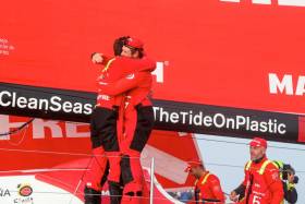
#VOR - The Spanish team MAPFRE stunned the Volvo Ocean Race fleet on Tuesday morning (8 May) by stealing a win in Leg 8 with a shocking come-from-behind victory into Newport, Rhode Island.
Twenty-four hours before, with just 300 miles to go, MAPFRE was in fifth place.
But as Tuesday morning dawned, and with the fleet ghosting towards the finish line in extremely light and shifty winds, Xabi Fernández’s team was among the leading quartet, battling in slow motion with Team Brunel, Dongfeng Race Team and Vestas 11th Hour Racing.
And even when the leaders were just 500 metres from the finish line, MAPFRE was still trailing Team Brunel as the pair emerged from the fog within sight of the spectators at the Fort Adams Race Village.
On approach to the final turning mark, MAPFRE picked up a zephyr of wind to sneak past Brunel and claim what just moments earlier would have been seen as a very improbable leg win.
“This is unbelievable,” skipper Xabi Fernández admitted moments after crossing the finish line. “I can’t be happier. We were always hoping to come back a little bit but to be honest we were not expecting to win this leg, so we’re super happy.
“Our hopes were always that there would be a compression so we could catch someone… Last night has been crazy how much everything has closed up and everyone on board did an amazing job.”
Bouwe Bekking’s Team Brunel, who had been leading for most of the past week after the equator crossing, took a well-deserved second-place finish.
Dongfeng Race Team, who had been ahead of the fleet on the approach to the east coast overnight Monday night, suffered the cruellest fate over the final miles.
Every break seemed to go against Charles Caudrelier’s team and after being in position to claim the leg win, they had to settle for fourth place, with Vestas 11th Hour Racing storming past Caudrelier’s crew in the final mile of the leg.
“This leg has had its ups and downs,” said Charlie Enright, the skipper of Vesta 11th Hour Racing. “We didn’t start great but we feel like we sailed pretty well for the middle two-thirds of the leg … Then with some positive input from some local knowledge, we end up back on the podium which is great.”
Newport is a homecoming for Enright and Nick Dana on Vestas 11th Hour Racing as well as Mark Towill, who did his college sailing nearby.
“It’s awesome here,” Enright said. “It’s 0600 local time here and the amount of boats out is absurd. The amount of effort put in by Sail Newport and the stopover here is amazing.”
The final hours were painful for the exhausted sailors but extraordinary to watch. With the wind nearly shutting down overnight on the approach to Newport, the fleet found itself pushed around by the tide and currents near shore, at times even drifting backwards, away from the finish line.
This meant there was a high degree of uncertainty. Positions were never secure until the finish line was breached by MAPFRE. No one suffered more in the final miles than Dongfeng’s Caudrelier.
“We’re very disappointed,” he said. “We were dreaming about a victory here … But it makes me angry and I will be better on the next one. I am already focussed on the future and I promise Dongfeng will do a fantastic job on the next one.”
The shocking win by MAPFRE has a huge impact on the overall race leaderboard where MAPFRE has regained the lead from Dongfeng, and now sits three points clear at the head of the table. Brunel retains the third podium position.
The light winds near the finish resulted in a massive compression in the fleet, all the way back to Sun Hung Kai/Scallywag, who were trailing the leaders by over 130 miles just one day ago.
But as MAPFRE crossed the finish line on Tuesday morning, David Witt’s team was less than 20 miles behind, and as of 1pm Irish time/12pm UTC has just eight miles to cover.
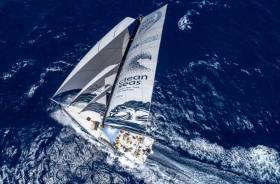
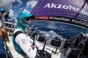
Meanwhile, Turn the Tide on Plastic — with Annalise Murphy representing Ireland on deck — were barely ahead of Team AkzoNobel just over a nautical mile from the finish line.
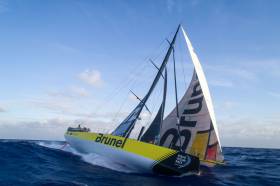
#VOR - Team Brunel were on the brink of Leg 8 victory today (Monday 7 May) as they led the seven-strong Volvo Ocean Race fleet towards Newport, Rhode Island with a 14-mile advantage.
The Dutch crew, skippered by esteemed round-the-world yachtsman Bouwe Bekking, were speeding up after making it through a light wind patch lying 200 miles from the finish line ahead of their rivals.
At 0700 UTC, their lead had been reduced to just seven miles, pressed hard by Franco-Chinese outfit Dongfeng Race Team, but six hours later the new breeze had allowed them to double that.
Brunel had just 182.2 miles to go at the 1300 UTC position update, having led the fleet on the 5,600-mile leg from Itajai, Brazil since exiting the Doldrums a week ago.
If Brunel were to hang on, it would be their second consecutive stage win having taken the top spot in Leg 7.
However, despite Brunel’s lead, helmsman Kyle Langford is predicting a photo finish.
“There’s going to be plenty of action on deck and not a lot of sleep,” he said. “It’s going to be all on for the last 24 hours.”
Across the fleet, the crews were today preparing for one last big push.
“We now have 30 hours of hard work, strong winds, light winds, big transitions and lots of sail changes,” said Dongfeng skipper Charles Caudrelier.
“All the team is in inshore mode and on standby. We have to keep this second place or pass Team Brunel, but ahead of us we face a very tricky situation and there are lots of options and maybe a re-start in light air in 12 hours’ time.
“We need maximum concentration. There is maximum stress on board but we are happy to arrive in this fantastic place for a stopover.”
Having climbed through the fleet over the past few days, at 1300 UTC MAPFRE had overhauled Dee Caffari’s Turn the Tide on Plastic in the rankings to move into third.
It’s a cruel blow for Turn the Tide on Plastic crew, among them Annalise Murphy, who have pushed for the top spot all leg and led at times. But skipper Dee Caffari said she wouldn’t stop fighting until the finish.
“It’s disappointing but there are still opportunities,” she said. “The wind is starting to fill, and it’s not over yet.”
The Volvo Ocean Race tracker will remain live until the end of the leg, showing race fans the exact positions of the fleet as they battle for Leg 8 glory. The latest ETA for the leading boats is 6am to 10am UTC/7am to 11am Irish time tomorrow morning, Tuesday 8 May.
Leg 8 Position Report, Monday 7 May (Day 16) at 4.30pm Irish time/3.30pm UTC:
- Team Brunel - DTF 164.4 nautical miles
- Dongfeng Race Team +12.2 nautical miles
- MAPFRE +12.7
- Turn The Tide on Plastic +22.7
- Vestas 11th Hour Racing +24.0
- Team AkzoNobel +58.0
- Sun Hung Kai/Scallywag +81.5
#VOR - The Volvo Ocean Race teams were preparing to gybe today (Sunday 6 May) and begin the final run into the Leg 8 finish in Newport, Rhode Island.
Team Brunel continue to hold the lead although Bouwe Bekking’s team have an advantage of less than nine miles on second-placed Dongfeng Race Team.
What’s more, the top five boats are only 38 miles apart after 14 days at sea, and with just over 500 miles of race track still remaining.
The positions are so close, as the fleet draws level with Bermuda, that it would be a bold call to make as to which team will arrive in Newport first.
Currently predictions are for top six teams to arrive within six hours of one another, between 1am and 7am Irish time on Tuesday (8pm to 2am on Monday night local time in Newport).
Speeds were down to the mid teens as the fleet feels the effect of the Bermuda High, an 800-mile-wide anticyclone to their east.
As the crews skirt the western boundary of the high, they will gybe and be able to point their bows towards Newport for the sprint to the finish.
“The ‘bleeding’ compared to Dongfeng has stopped,” Bekking wrote. “The closest they got to us was 2.6 miles, we could read the sign writing on their sails.
“We had the plan not to match their angles. They sailed higher and faster, plus had better breeze. All the forecasts we had said that being west would be the way to go in the long run.
“Also that way we kept basic sailing rule number one in place - stay in between the finish and your opponent. Slowly but surely it started paying off and we started edging out and they are now just over eight miles dead upwind (behind) of us.
“I am sure they are kicking themselves, as 24 hours ago they were more west than us. We matched last night two gybes against them, just to keep it simple and not to let them off the hook.”
Despite effectively being level with Team Brunel, Vestas 11th Hour Racing are further east, closer to the high – and that could have implications over the remaining hours and days of Leg 8.
“For the briefest of moments it looked like we have been able to get to the top of the leader board, in fact it was tantalisingly close at one point,” Vestas 11th Hour Racing’s navigator Simon Fisher said.
“However, the reality is although we have got close to Brunel and Dongfeng in terms of distance to finish they are currently placed a little more safely on the outside of us as we approach the Bermuda High.
“With that said though if we can hang on to them for the next 18 to 24 hours it could all be to play for once we gybe onto port and approach Newport.”
Once on the road to Newport, the fleet will have to contend with a cold front harbouring winds of more than 35 knots, before facing a tricky transition into north-easterly breeze.
It means the Leg 8 podium could well be decided in the final 24 hours – and every moment up until that point could have its consequences.
“The truth is that in the next 36 hours there is still a lot to come,” said Xabi Fernández, skipper of fifth-placed MAPFRE. “We have a low pressure coming with plenty of wind downwind where we will need to push all we’ve got, and then we have to cross a front to get to NE winds which will be challenging and pretty cold I’m sure.”
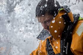
 Annalise Murphy having slightly different hair wash on board Turn the Tide on Plastic yesterday, Saturday 5 May (Photo: James Blake/Volvo Ocean Race)
With fourth-placed Turn the Tide on Plastic — including Annalise Murphy on deck — around nine miles directly west of MAPFRE, Fernandez said his crew would aim to repeat their success in Leg 6 into Auckland when they overhauled their rivals in the final few miles.
“We still remember how much we had to push to get them in Auckland and I’m sure this time is going to be even more difficult but that is our goal right now,” Fernández added.
The race tracker remains live for what is looking like will be a thrilling finish to Leg 8. Be sure to follow it for all the latest positioning.
Leg 8 Position Report, Sunday 6 May (Day 15) at 2.04pm Irish time/1.04pm UTC:
- Team Brunel - DTF 539.7 nautical miles
- Dongfeng Race Team +8.2 nautical miles
- Vestas 11th Hour Racing +27.2
- Turn The Tide on Plastic +33.7
- MAPFRE +38.3
- Team AkzoNobel +61.5
- Sun Hung Kai/Scallywag +133.5
#VOR - Less than 1,000 miles separate the leading Volvo Ocean Race boats from the finish line in Newport, Rhode Island, as Leg 8 heads towards an action-packed conclusion.
Charles Caudrelier’s Dongfeng Race Team, the overall race leader, has spent the past 24 hours grinding down leg leader Team Brunel and as of Saturday afternoon, is nearly in position to make a pass.
On Friday at noon UTC, Brunel had a 12-mile lead over Dongfeng. Twenty-four hours later, the advantage is less than three miles, with the red boat in sight and sailing directly behind Bouwe Bekking, making up distance slowly but surely.
With the leaders now having less than 1,000 miles to sail to the finish line in Newport, Rhode Island approximately three days away, the gains couldn’t come at a better time for Caudrelier’s Chinese-flagged Dongfeng.
“We would prefer to be ahead… but it’s not too bad. We’ve come back very close now. It’s nothing. We’re happy about the position, it could be much worse,” Caudrelier said.
“For the moment we are faster but we think they are getting slightly less wind ahead. There is plenty to do coming up. A decision on a gybe, the peeling (sail maneuverers, so it will not be only about speed. I also think Vestas might come out very close to us.”
As Caudrelier says, the two leaders aren’t having it all their own way. Nearly 30 miles directly to the east, Vestas 11th Hour Racing is making a move as well. The team has leverage for the upcoming wind shift and gybe and is hoping to sneak around the front of the two leading boats to lead into skipper Charlie Enright’s home port of Newport, Rhode Island.
“All of the action in this leg is going to happen quite quickly at the end,” said Simon Fisher, the navigator on Vestas 11th hour Racing. “We’ve got a big high pressure coming up and as we approach it we’re going lifted and lifted and lifted and the wind is going to get lighter and then we’ll have to pick our moment to gybe and head out the high pressure.
“Right now we’re trying to weigh up being the first boat to the shift, bow forward versus trying to stay in more wind by getting to the west. Our main competition is further west, so they’ll be in better pressure but we might get the shift first. So we have to do some good work to get in that position to gybe and come out ahead.
“After that there will be another front to negotiate and a high pressure coming off New England so it’s all happening the last couple of days. It’s going to be full of action.”
Overall, there has been compression in the fleet, with each of the trailing boats making up miles over the past 24 hours.
Turn the Tide on Plastic remain in fourth place, 27 miles back of the leader, while Team AkzoNobel and MAPFRE continue their private match race a further 20 miles back.
Sun Hung Kai/Scallywag have been the biggest gainer over the past 24 hours, but remain 165 miles in arrears.
Leg 8 Position Report, Saturday 5 May (Day 14) at 2.20pm Irish time/1.20pm UTC:
- Team Brunel - DTF 933.9 nautical miles
- Dongfeng Race Team +2.8 nautical miles
- Vestas 11th Hour Racing +7.2
- Turn The Tide on Plastic +28.6
- MAPFRE +47.0
- Team AkzoNobel +49.4
- Sun Hung Kai/Scallywag +164.6
#VOR - Bouwe Bekking’s Team Brunel continues to lead the Volvo Ocean Race fleet towards the Leg 8 finish in Newport, Rhode Island as the teams enter the final 1,500 miles.
Bekking’s Dutch-flagged crew jumped into the top spot on Tuesday 1 May after exiting the Doldrums and have so far defended their position despite spirited attacks from their rivals.
Twelve days into the 5,600-mile sprint from Itajaí in Brazil, the quick sailing through the trade winds was continuing on Friday (4 May) — although lighter winds lie in wait further down the track, meaning Brunel’s lead of seven miles is far from secure.
Bekking said his crew were making the most of the ideal conditions while they last.
“We are pushing to the max we can do,” the veteran Volvo Ocean Race sailor said. “We know we are sailing into less pressure so the boats behind us will keep gaining, annoying but a fact we have to live with.
“Capey, our navigator, is relaxed in his own way, but can see and feel that it is game on. He makes I don't know how many simulations for all the routes possible from here to Newport and we are discussing this together with Pete (Burling) as well.
“Two very important factors are the high pressure system east of Bermuda and the Gulf Stream which runs from Florida into a north east direction towards Europe.
“The current can run up to five to six knots. Unfortunately it is not one straight stream, it has big eddies, so if you do it wrong you can have five knots against you while another boat has five knots with them. But we are confident!”
Around 25 miles south east of Brunel, Dee Caffari’s Turn the Tide on Plastic — with Ireland’s own Annalise Murphy on board — slipped out of the podium spots after hitting a patch of lighter wind.
As the seven teams drew level with Puerto Rico, Vestas 11th Hour Racing were able to skirt round the outside of them into third.
“Three disappointing position reports in a row is frustrating and could get you down,” Caffari said. “However, we will fight harder, we just need to let these rain clouds know…
“During the early hours of this morning the rain clouds carried some squally action and huge shifts. One minute we were in 28 knots of wind heading towards the Caribbean and then the next moment we were lifted, towards the centre of the high pressure, in 14 knots of wind.
“We can only sail in the conditions that we have and we are working hard but it seems everyone else’s clouds are more user friendly allowing them to keep gaining on us and we are slipping back.
“If it is not the up and down and shifts of the wind then it is this Sargassum weed. Rudders no longer having smooth water flow lose grip and the boat spinning out is not fast.
“We have two more days of this express highway and then the breeze will start to decrease before we gybe and sail on port. We then face a lot of action and sail changes between us and the finish from that gybe point.”
Out to the east of the leaders, MAPFRE and Team AkzoNobel are in a dead heat for fifth place, about 45 miles off the lead.
Meanwhile, seventh-placed Team Sun Hung Kai/Scallywag clawed back miles on the leaders as they posted the best 24-hour distance run of the fleet, notching up 513 miles.
Scallywag crew member Pete Cumming, racing in his first Volvo Ocean Race leg, said the crew had not lost hope of catching their rivals despite a 181-mile deficit on Brunel.
“We still believe it’s going to be close at the finish,” he said. “There’s going to be a transition close to the finish and our routing has us coming in a few hours behind the leaders.”
Leg 8 Position Report, Friday 4 May (Day 13) at 3.18pm Irish time/2.18pm UTC:
- Team Brunel - DTF 1,400.6 nautical miles
- Dongfeng Race Team +7.2 nautical miles
- Vestas 11th Hour Racing +12.5
- Turn The Tide on Plastic +21.2
- MAPFRE +45.0
- Team AkzoNobel +45.2
- Sun Hung Kai/Scallywag +178.2
#VOR - The Volvo Ocean Race teams were enjoying full-speed trade wind sailing on Wednesday (2 May) as they knocked off the miles to the Leg 8 finish in Newport, Rhode Island.
Stage leaders Team Brunel continue to set the pace as they blast along at more than 22 knots, matching the wind for speed, and holding a narrow 15-mile jump on second-placed Dongfeng Race Team.
The top trio, which also includes Turn the Tide on Plastic with Annalise Murphy on deck, were less than 30 miles apart as the battle for Leg 8 supremacy continued on the 10th day at sea.
Just over 2,300 miles remain between the leaders and the finish line.
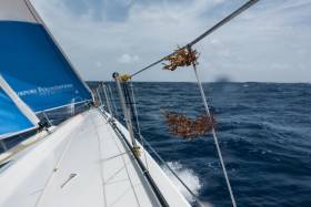
Despite fast sailing, however, the crews were facing a common enemy intent on slowing them down: huge drifts of Atlantic seaweed.
The Sargassum weed is named after the Sargasso Sea, the region of the North Atlantic directly off the coast of the United States and stretching down to the Caribbean.
Sargassum has been creating problems for sailors since the days of Christopher Columbus and now, more than 500 years later, it continues to cause havoc for the Volvo Ocean Race fleet.
A clump of seaweed stuck on a dagger board, keel or rudder, can slow a team down by several knots, as well as affecting the control the helmsman has over the boat.
“We are speeding along with lots of water everywhere and in the water washing down the deck is an abundance of sargassum weed,” said Turn the Tide on Plastic skipper Dee Caffari.
“The boat looks more like a garden now with green shrubbery everywhere. Then you feel that you are no longer in control of the leeward rudder driving the boat and yet you try and turn the wheel.
“A couple of short sharp pulses to leeward normally can gain control again, but it does no good. You feel the vibrations growing and the noise of cavitation round the rudder builds.
“Without water flow there is no steerage and the boat wants to round up to weather. Again you pulse the wheel to leeward and look out behind the boat to see a huge rooster tail confirming what you thought, the amount of weed stuck around the rudder is having a huge effect.
“The boat still wants to go fast but it feels like it is sailing in treacle as it slows down despite the wind and waves. Eventually you fight the pull and get the boat turned downwind. She heels to weather and the rudder gets the chance to free itself of weed, the rooster tail disappears and the cavitation stops.
“You are back in control and up to course sending it again. Oh the joy of sailing through this area of weed!”
Xabi Fernandez’s MAPFRE crew were equally scornful of the weed as they try to climb up the rankings from fifth place, some 75 miles behind the leaders.
“It is quite annoying because you can see how the boat speed decreases, and sometimes you even lose the steering of the boat because the rudder is full of seaweed and it does not allow you to sail the boat normally,” Pablo Arrarte said.
MAPFRE were also temporarily slowed when one of their steering cables broke, but quick work from boat captain Antonio ‘Neti’ Cuervas-Mons saw them back up to full capacity within 30 minutes.
Team Sun Hung Kai/Scallywag might be 200 miles behind Team Brunel but they were today suffering the same fate with the Sargassum weed.
“There’s seaweed all over the place, and it smells,” said crewman Alex Gough, “although we’re not sure if it’s the seaweed or Nipper [Ben Piggott]!”
Leg 8 Position Report, Wednesday 2 May (Day 11) at 1.54pm Irish time/2.54pm UTC:
- Team Brunel - DTF 2,301.9 nautical miles
- Dongfeng Race Team +19.7 nautical miles
- Turn The Tide on Plastic +30.0
- Vestas 11th Hour Racing +48.1
- MAPFRE +76.7
- Team AkzoNobel +98.3
- Sun Hung Kai/Scallywag +213.3
Highest Microplastic Levels Found In South China Sea
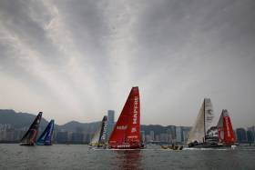
#Microplastic - The Volvo Ocean Race Science Programme has found the highest levels of microplastic in the South China Sea during Leg 6 from Hong Kong to Auckland this past spring.
Preliminary results show a whopping 360 particles of microplastic per cubic metre in the sample from the South China Sea, an area that feeds into the Great Pacific Ocean Gyre.
The Great Pacific Ocean Gyre is one of five major gyres, driven by trade and westerly winds, which collect large concentrations of plastic debris.
In total, this gyre is thought to weigh around seven million tons and is twice the size of Texas.
The previous highest levels of 307 particles per cubic metre were discovered in the area where the Mediterranean Sea and Atlantic Ocean meet.
Sailor Liz Wardley took the samples on Turn the Tide on Plastic as it travelled from Hong Kong east into the north Philippine Sea.
The high readings coincided with the boat entering the Kuroshio current, which feeds the ocean gyre.
Dr Toste Tanhua of the GEOMAR Institute for Ocean Research Kiel, funded by the Cluster of Excellence Future Ocean, analysed the preliminary microplastics data at the laboratory in Kiel, Germany.
“Microplastic particles are mostly coming from land and are passively distributed by currents that can be very local in extent,” Dr Tanhua said. “Since the race yachts are not continuously sampling for microplastic, it can easily be that concentrations are very different for locations close to each other in areas of strong currents.
“The leg 6 data indicate high concentrations of microplastics close to the Asian continent, not unexpected considering the use of single-use plastics in this region.”
The route of Leg 6 partially overlapped the track that the boat sampled during the northbound passage to Hong Kong during Leg 4, providing a second sampling opportunity in some areas.
But there was a notable difference between levels of microplastics recorded during this leg compared to Leg 4 on the approach to Hong Kong from Melbourne.
The latest sample is possibly more representative of actual levels as it was taken closer to land and further northeast than the earlier sample.
Along the route south through the Pacific and crossing the equator, average levels in the areas sampled were around 100 particles per cubic metre. These recorded levels also differed considerably from those recorded during the northbound passage of Leg 4, when just seven particles per cubic metre were measured. Again, prevailing currents in this offshore area will be a major factor affecting microplastic density.
Progressing south towards New Zealand, the concentration increased from 45, 50, 56 to 60 particles per cubic metre in the sample closest to Auckland.
The information comes from the Volvo Ocean Race Science Programme, which has brought together an elite scientific consortium to capture data that will contribute to a better understanding of the world’s ocean and climate.
Microplastics are often invisible to the naked eye and can take thousands of years to degrade. By collecting information on their levels, the mission is helping scientists gain insight into the scale of plastic pollution and its impact upon marine life.
The Volvo Ocean Race Science Programme is funded by Volvo Cars, who are donating €100 from the first 3,000 sales of the new Volvo V90 Cross Country Volvo Ocean Race edition to support the initiative.
Turn The Tide Fights For Lead In Volvo Ocean Race Leg 8
#VOR - Four teams are within four miles of the lead as Leg 8 of the Volvo Ocean Race enters its second week on Sunday morning.
As at 1.40pm Irish time/12.40am UTC on Sunday morning, Turn the Tide on Plastic had lost a hard fight all morning long to fend off the attack of Vestas 11th Hour Racing.
Just behind that pair, Dongfeng Race Team and Team Brunel have also been gybing back and forth along the northeast coast of Brazil to take advantage of favourable current over the past 18 hours.
“We have Vestas just off our stern, Dongfeng is up to windward, abeam of us and Brunel is just off our hip,” said Bianca Cook from Turn the Tide on Plastic this morning, shortly before letting their lead slip. “We’ve had a few clouds that haven’t really gone in our favour and so they’ve started to creep up on us…
“We’re concentrating on our performance, tweaking everything all the time, but for sure the pressure is on when these boats are just behind you. But it’s nice to have the lead and we’re confident in our ability to beat these guys to the finish.”
Now free of the Brazilian coast line, the teams will be looking to choose their lane into the doldrums, some 250 miles to the north — although with the fleet this far west, this is forecast to be the easiest of the four crossings in this race.
And while the pressure to perform remains, this weather is probably giving the sailors the most comfortable conditions of the race.
“Life is good on board, and dry on deck and after the first night without squalls the team is well rested and in good spirits,” wrote Simon Fisher from on board Vestas 11th Hour Racing. “We can make out Turn the Tide ahead and Dongfeng behind giving us both motivation to chase and to not get caught.”
Further back, Team AkzoNobel, MAPFRE and Sun Hung Kai/Scallywag will be looking at the doldrums for an opportunity to close the gap.
Team AkzoNobel, the closest at just 13 miles behind, is already forging a different path, sailing directly north, but fully 25 miles to the east of the leading quartet.
You can follow the progress of the fleet on the race tracker, now testing in live mode for the remainder of the Leg 8.
Leg 8 Position Report, Sunday 29 April (Day 8) at 1.20pm Irish time/2.20pm UTC:
- Vestas 11th Hour Racing - DTF 3,384.6 nautical miles
- Turn The Tide on Plastic +1.0 nautical miles
- Dongfeng Race Team +3.0
- Team Brunel +3.0
- Team AkzoNobel +7.3
- MAPFRE +26.8
- Sun Hung Kai/Scallywag +60.0
Annalise Murphy & Company Convert Easterly Position Into Northerly Advantage In Volvo Ocean Race
#VOR - Dee Caffari’s Turn the Tide on Plastic saw their strategy pay off on Friday (27 April) as they regained the lead in Leg 8 of the Volvo Ocean Race.
Caffari’s crew – including Ireland's own Annalise Murphy – set themselves up as the most easterly boat as the seven-strong fleet climb up the coast of Brazil, bound for the finish in Newport, USA some 4,000 miles away.
Caffari and Turn the Tide on Plastic navigator Nico Lunven gambled that being furthest east would yield results, with better breeze giving them a boost on their rivals.
And as Leg 8 approached its sixth day, their tactics seemed to have paid off as they edged out a lead of more than 11 miles on former leg leaders Vestas 11th Hour Racing.
Despite their gains, it has been anything but plain sailing for Turn the Tide on Plastic as they try to dodge the huge South Atlantic clouds threatening to slow their progress north.
“We have reached the point where we can ease the sheets and sail faster, however the clouds have a different idea,” Caffari said.
“Last night we spent about eight hours under a cloud with the pressure changing all the time, the wind direction shifting all the time and it constantly raining.
“Endless sail changes relied on the crew being up for most of it and so there was very little sleep to be had. Even now we have cleared the monster clouds we have constant clouds rolling through.
“Some big some small, all with a wind pressure change, all with a slight wind shift and some with some precipitation. We have made a sail plan choice that allows us to make good progress when we are in real wind and able to adjust to the changes when we are facing yet another cloud.
“We now just need to keep trying to go fast in the right direction. Not always easy when yet another cloud is trying to make you wait for the others to overtake.”
Challenges aside, the mood onboard Turn the Tide on Plastic remains high.
“We’re leading right now which is fantastic,” Italian crew member Francesca Clapcich said. “We’re sailing a really solid leg – we just have to keep doing what we’re doing for another two weeks!”
The frontrunners aren’t the only ones suffering in the unstable weather brought about by the cloud activity.
With winds rocketing from less than 10 knots to 30 in a matter of minutes the chasing pack are just as susceptible to being caught out.
“There’s a lot of hot air where we are, and a lot of energy being created,” said Rob Greenhalgh, helmsman on sixth-placed MAPFRE. “These clouds pop up all over the place and they’re massive.
“Hopefully we’re through the worst of it now. The forecast for the next 48 hours is for lifting breeze and slightly faster angles.”
At 1300 UTC, MAPFRE were trailing Turn the Tide on Plastic by 48 miles but were the fastest boat in the fleet, making 16.2 knots.
“We’re in not too bad a shape but Turn the Tide are pushing forward and will continue to do so,” Greenhalgh added. “Hopefully things then change a bit and we can start getting back into them.”
Sun Hung Kai/Scallywag were today paying the price for being the most westerly boat, slipping to almost 50 miles behind the frontrunners.
The race tracker is currently live and will remain so for another 24 hours, allowing race fans to live out the battle for Leg 8 in real time.
Leg 8 Position Report, Friday 27 April (Day 6) at 4.20pm Irish time/3.20pm UTC:
- Turn The Tide on Plastic - DTF 4,003.7 nautical miles
- Vestas 11th Hour Racing +11.1 nautical miles
- Dongfeng Race Team +21.6
- Team Brunel +29.3
- Team AkzoNobel +30.5
- MAPFRE +49.8
- Sun Hung Kai/Scallywag +56.7
Volvo Ocean Race Fleet Locked In & Heading North Off Brazil
#VOR - The Volvo Ocean Race teams were practically neck and neck in Leg 8 on Thursday (26 April) with the seven crews jostling for position as they close in on the trade winds.
Over the past 48 hours, each team has thrown their cards on the table, lining up west to east and committing to the routing they think will best fire them towards the steady, favourable breeze the trade winds offer.
Sun Hung Kai/Scallywag plumped for the most westerly position, setting themselves up around 120 miles off the Brazilian coastline.
Forty miles further out to sea, and on the same parallel, Turn the Tide on Plastic were the most easterly boat, pinning their hopes on being the first to pick up the new breeze when it arrives in the next 24 hours.
Splitting the difference, and with the narrowest of advantage just slightly north of their rivals, Vestas 11th Hour Racing had usurped Annalise Murphy and her cremates on Turn the Tide from the top spot at the 1300 UTC position update.
Turn the Tide skipper Dee Caffari said she was willing to lose out temporarily in favour of a better position for the new breeze.
“Yesterday was all about making short term losses to make long term gains,” she said. “That is what I was telling the team as we pushed out to the east while it was easy to gain miles in that direction.
“Today we are dealing with a sequence of rain clouds as best we can. Some have a shift in them and some carry just an increase in pressure. We hope the latter are only for us so we can accelerate on our competitors while in the cloud. Fingers crossed for some lady luck in the clouds we encounter on this leg.
“We believe, with the exception of random cloud activity, that this is us on starboard for a very long time.”
Simeon Tienpont’s Team AkzoNobel was one of the teams that managed to benefit from a cloud, overtaking Team Brunel and Scallywag overnight.
“The big difference is how you manage the clouds,” AkzoNobel’s Chris Nicholson said. “We made a huge gain on Vestas and MAPFRE then lost it all in a cloud. In a straight line and with the same breeze there’s not much difference between the teams - the deciding factor is getting through the clouds.”
Meanwhile on Team Brunel, thoughts are already turning to the impending crossing of the Equator for the fourth time in this edition.
Maritime tradition dictates that those who haven’t crossed the Equator before must make an offering to King Neptune.
Brunel’s only inductee on this leg is Australian Olympic silver medallist Nina Curtis – and the crew are already enjoying the anticipation.
“Nina is get a bit worried about King Neptune’s visit, even though it is still days away,” Brunel skipper Bouwe Bekking said. “The guys love to wind her up. We will make sure she doesn’t lose all her hair…”
The next 24 hours are so crucial to the outcome of the leg that the race tracker has gone live, giving race fans real-time information about the position of the boats.
Leg 8 Position Report, Thursday 26 April (Day 5) at 4.13pm Irish time/3.13pm UTC:
- Vestas 11th Hour Racing - DTF 4,290.7 nautical miles
- Turn The Tide on Plastic +0.65 nautical miles
- Dongfeng Race Team +2.85
- MAPFRE +4.59
- Team AkzoNobel +6.29
- Team Brunel +10.29
- Sun Hung Kai/Scallywag +14.07


, and Dermot O’Kane, Head of Sales, Esri Ireland. Esri Ireland is announcing that its digital mapping system is helping DURL to prevent 13 million litres of polluted wastewater from entering Dublin rivers annually, by locating misconnected household appliances that are expelling polluted water")


